A blue line follows a river channel. A drainage basin includes the land feeding that channel, often far beyond its banks and across several states. Reading the two together explains why the Missouri and Ohio belong to a larger Mississippi network, while neighboring rivers can lead to different seas or no sea at all.
Major U.S. rivers form connected drainage systems, including the Mississippi and its tributaries, the Columbia–Snake system, and the Colorado and Rio Grande basins. The maps below show selected river channels and 18 broad USGS hydrologic regions in the contiguous United States. A hydrologic region is not always one complete natural river basin.
Find your route: Use the numbered river key, distinguish regions from basins, follow the Mississippi network, or explore inland drainage.
1. Major U.S. rivers map and key
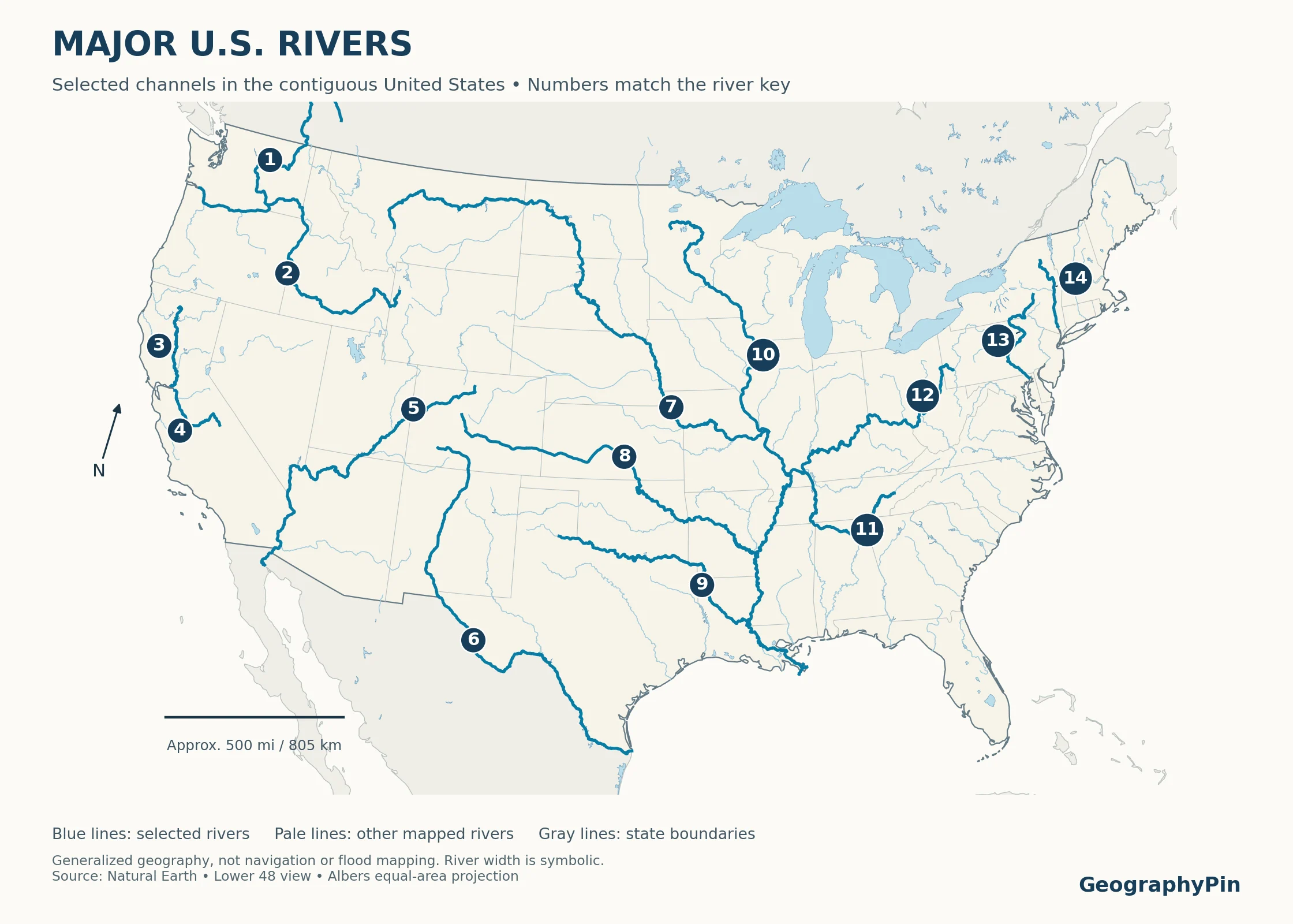
The first map is a selected-river map of the lower 48 states, not a ranking of the longest rivers or a complete inventory. Its 14 highlighted rivers provide recognizable routes through the major western, central and northeastern drainage systems. Alaska, Hawaii and U.S. territories are outside this map’s scope.
Enlarge map · Download printable map (PDF)
The numbered river key
“Downstream connection” describes the geographic route, not a guarantee that all water reaches the ocean in every season. Reservoir storage, diversions, evaporation and drought can interrupt or greatly reduce downstream flow.
| Map number and river | Where to look | Downstream connection |
|---|---|---|
| 1 · Columbia | Pacific Northwest | Pacific Ocean |
| 2 · Snake | Interior Northwest | Columbia River → Pacific Ocean |
| 3 · Sacramento | Northern California | Sacramento–San Joaquin Delta → San Francisco Bay |
| 4 · San Joaquin | Central California | Sacramento–San Joaquin Delta → San Francisco Bay |
| 5 · Colorado | Southwestern United States | Gulf of California; flow to the sea is heavily affected by water use |
| 6 · Rio Grande | Colorado, New Mexico and the Texas–Mexico border | Gulf of Mexico |
| 7 · Missouri | Northern and central interior | Mississippi River |
| 8 · Arkansas | Central and southern interior | Mississippi River |
| 9 · Red River of the South | Southern Plains and Louisiana | Atchafalaya River |
| 10 · Mississippi | Central United States | Gulf of Mexico |
| 11 · Tennessee | Southeastern interior | Ohio River → Mississippi River |
| 12 · Ohio | Eastern interior | Mississippi River |
| 13 · Susquehanna | Northeastern United States | Chesapeake Bay → Atlantic Ocean |
| 14 · Hudson | New York | New York Harbor → Atlantic Ocean |
The Red River shown here is the Red River of the South, not the separate Red River of the North.
2. Drainage basins and the USGS region map
A drainage basin, also called a watershed or catchment, is the area contributing drainage to a chosen outlet. That outlet might be a river mouth, a lake, or a monitoring station farther upstream. A tributary therefore has its own basin nested inside the larger basin of the river it joins.
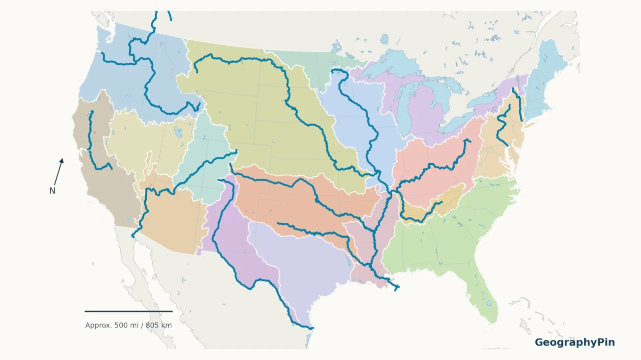
The second map uses actual boundaries from the USGS Watershed Boundary Dataset. The colors distinguish two-digit Hydrologic Unit Code regions, usually shortened to HUC2 regions. These are broad, organized units useful for national-scale water mapping.
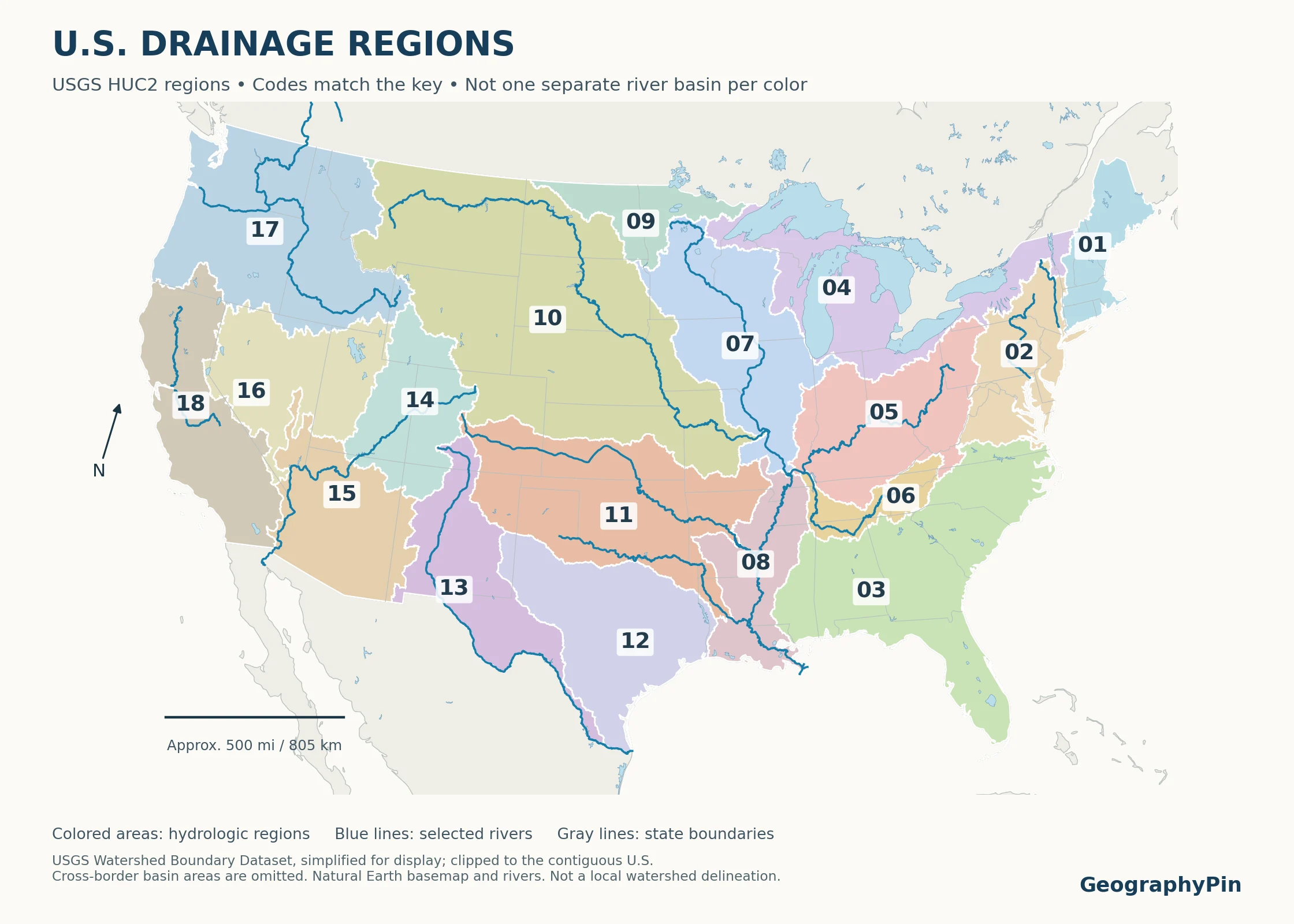
Enlarge map · Download printable map (PDF)
| HUC2 code | Region name |
|---|---|
| 01 | New England |
| 02 | Mid-Atlantic |
| 03 | South Atlantic-Gulf |
| 04 | Great Lakes |
| 05 | Ohio |
| 06 | Tennessee |
| 07 | Upper Mississippi |
| 08 | Lower Mississippi |
| 09 | Souris-Red-Rainy |
| 10 | Missouri |
| 11 | Arkansas-White-Red |
| 12 | Texas-Gulf |
| 13 | Rio Grande |
| 14 | Upper Colorado |
| 15 | Lower Colorado |
| 16 | Great Basin |
| 17 | Pacific Northwest |
| 18 | California |
Why a region is not always a basin
Some regions divide a connected river system. For example, Upper Colorado and Lower Colorado are separate mapping regions within the Colorado River system. Other regions group several independent coastal rivers. Texas-Gulf is not the name of a single river, and the California region is not solely the Sacramento–San Joaquin basin.
USGS explicitly notes that hydrologic units can include administrative divisions, modified drainage and breaks in connected systems. Even the Lower Mississippi region includes some nearby coastal drainage. Adding broad regional polygons together is therefore not automatically an exact delineation of a named river’s basin.
3. How the major river systems connect
The Mississippi network
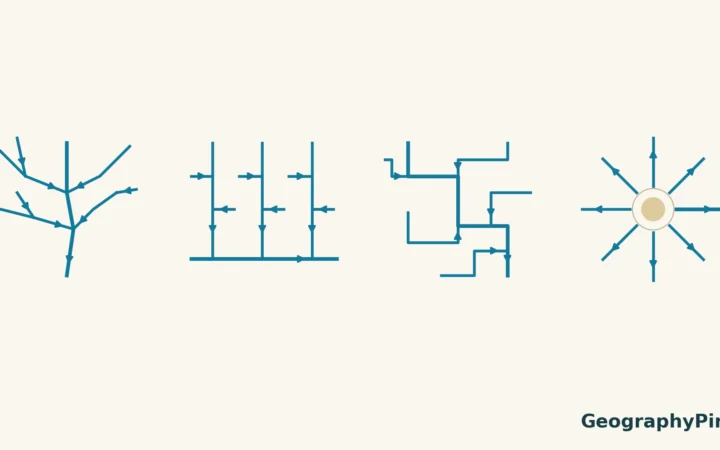
The Mississippi is the central trunk of a large branching network. The Missouri joins it from the west; the Ohio arrives from the east; and the Arkansas reaches it farther south. The Tennessee first joins the Ohio, so its water enters the Mississippi indirectly.
This is the difference between a river name and a drainage system. Standing beside the Tennessee does not put you beside the Mississippi channel, but it does place you within that connected drainage network. The basin concept follows the downstream route rather than the name printed on the nearest blue line.
The southern Red River needs extra care. Its modern downstream connection is the Atchafalaya, which also receives Mississippi water through the managed Old River system. Calling the Red simply a direct Mississippi tributary hides an important feature of the lower river network.
The Columbia–Snake and Colorado systems
In the Northwest, the Snake joins the Columbia, and the Columbia reaches the Pacific. The Pacific Northwest HUC2 region is broader than that one river basin because it also includes other Pacific-draining rivers. The international border does not mark the Columbia’s headwaters: the river begins in Canada.
The southwestern Colorado River belongs to a different drainage system, leading toward the Gulf of California. Its basin is not the same as the state of Colorado. Nor should it be confused with the separate Colorado River in Texas, which is not one of the 14 highlighted channels on this map.
California and Atlantic connections
The Sacramento flows into the Sacramento–San Joaquin Delta from the north and the San Joaquin from the south. Their shared estuary connects with San Francisco Bay and the Pacific. This is a useful example of two major named rivers meeting within an interconnected delta rather than one tidy inland confluence.
On the Atlantic side, the Susquehanna enters Chesapeake Bay. The Hudson reaches New York Harbor. These rivers are grouped in the Mid-Atlantic hydrologic region, but they do not merge into a single river before reaching the sea.
4. Divides, inland drainage and cross-border basins
Divides follow terrain, not state lines
A drainage divide separates land draining toward different outlets. A ridge can be a divide, but a divide need not be a dramatic mountain crest. Much flatter terrain also separates river systems. State borders, by contrast, are political boundaries and often cut across drainage areas.
Rocky Mountain National Park illustrates the large-scale pattern: runoff on one side of its continental divide joins the Colorado system, while runoff on the other side reaches the South Platte and eventually the Mississippi system. The physical map of the United States helps place these routes against the mountain ranges and plains.
The Great Basin has many inland outlets
Not every drainage route leads to an ocean. Much of the interior West contains closed basins, where surface drainage ends in lakes, playas or sinks. Water can then evaporate or infiltrate rather than leave through an ocean-bound river.
The National Park Service emphasizes that the Great Basin is actually a collection of smaller basins. Its hydrographic, geologic and ecological definitions also differ. The map’s code 16 refers specifically to the USGS Great Basin hydrologic region, not every place called part of the Great Basin Desert or Basin and Range province.
Drainage crosses international boundaries
The Great Lakes connect naturally to the Atlantic through the St. Lawrence system. Farther west, the Souris-Red-Rainy region belongs to drainage leading toward Lake Winnipeg and Hudson Bay, not toward the Mississippi. These northern routes explain why “all U.S. rivers flow south” is wrong.
Several large systems also cross into Canada or Mexico. The shaded region map deliberately stops at the contiguous U.S. boundary. An unshaded area north or south of that border may still feed one of the same rivers. It is outside the displayed coverage, not necessarily outside the watershed.
5. Read the maps without confusing size and flow
- River length is not basin area. A long channel and a broad catchment describe different properties.
- Basin area is not discharge. A dry, extensive basin can deliver less water than a smaller wet one. Rain, snow, geology, storage and water use all matter.
- Blue does not mean navigable. These lines do not identify navigable depth, current, hazards or access.
- A line is not a flood boundary. Floodplain and flood-hazard maps require different data.
- Numbers are identifiers, not rankings. River numbers 1–14 and HUC2 codes 01–18 belong to separate keys.
For the underlying concepts, see river parts and drainage basins. To understand how smaller channels form larger networks, use the Strahler stream-order explanation. For actual measured conditions, reading a river gauge is a different task from reading a national map.
Frequently Asked Questions
Can groundwater cross a surface drainage divide?
Yes. Surface divides describe the direction of overland drainage, while groundwater follows hydraulic gradients and the structure of aquifers. Underground drainage does not always match the surface boundary.
How can I find the exact watershed for my address?
Use a detailed official watershed or stream-network map and choose the relevant outlet. This national map is too generalized for property-level decisions; the USGS hydrologic-unit resources provide a better starting point.
Does a dam move the boundary of a river basin?
A dam normally changes storage and flow within a drainage system rather than moving the surrounding topographic divide. A diversion that transfers water across that divide can change where some water goes without relocating the natural divide itself.
What Did We Learn Today?
A river map becomes more useful when channels are read as parts of connected drainage systems. Tributaries nest inside larger basins, some waters end inland, and others cross international borders. USGS hydrologic regions organize that geography, but their boundaries must not be mistaken for a simple one-color, one-river scheme.
Sources & Data Notes
The original maps combine Natural Earth river and lake geometry with USGS Watershed Boundary Dataset HUC2 polygons retrieved in November 2026. Region boundaries were simplified for display and clipped to the contiguous United States, using an Albers equal-area projection. Numbers identify selected rivers or official region codes, not ranks. The river selection is educational, not exhaustive; no basin areas were calculated from these generalized maps. They are not navigation, property, flood-risk or water-rights maps.
- USGS Water Science School: Watersheds and Drainage Basins
- USGS: Hydrologic Units of the United States and Watershed Boundary Dataset region layer
- USGS hydrologic-region names and codes
- Natural Earth: Rivers and Lake Centerlines
- National Park Service: Watersheds and The Great Basin
- USGS: Mississippi–Red–Atchafalaya geographic setting
- California Water Boards: Bay-Delta Program
- USGS: Souris-Red-Rainy drainage