The edge of a continent does not stop at the beach. Beneath the sea, its margin can include a shallow platform, a steeper descent and a sediment-covered transition toward the deep ocean. The names shelf, slope and rise describe different parts of that underwater landscape.
The continental shelf is the relatively shallow, gently sloping submerged platform beside a continent. The continental slope is the steeper descent beyond the shelf break. A continental rise is a gentler sediment apron at the slope’s base where one develops. This familiar sequence describes a common margin, not a universal layout or a legal maritime boundary.
Choose a starting point: compare the three features, decode the numbered diagram, or check why legal shelf boundaries are different.
1. Shelf, Slope and Rise Compared
Three parts of a continental margin
A continental margin is the transition between a continent and the deep-ocean basin. In a familiar passive-margin profile, the shelf is closest to land, the slope lies farther seaward, and the rise spreads beyond the slope’s base. The abyssal plain is the comparatively flat deep-ocean floor beyond that transition.
| Feature | Position | Useful identifying clue | Common mistake |
|---|---|---|---|
| Continental shelf | Submerged platform extending away from the coast | Relatively shallow water and gentle overall gradient | Assuming it has one fixed width everywhere |
| Shelf break | Outer edge of the shelf | Change toward the steeper continental slope | Treating it as a perfectly uniform depth contour |
| Continental slope | Beyond the shelf break | Steeper descent toward the deep basin | Imagining a single vertical cliff |
| Continental rise | At the slope’s base where developed | Gentler transition built from accumulated sediment | Assuming every margin has one |
These terms are relative descriptions of shape and position. “Shallow” means shallow compared with the deep basin, not shallow enough to stand in. “Steep” distinguishes the slope from the shelf and rise; it does not mean the whole continental slope is a sheer wall. Local cliffs and canyon walls can be much steeper than the regional profile.
Likewise, “rise” is a name for the apron at the base of the slope, not evidence that the seabed must climb upward as you travel from shore toward the ocean. In a simple profile, the surface can continue deepening seaward while becoming much less steep.
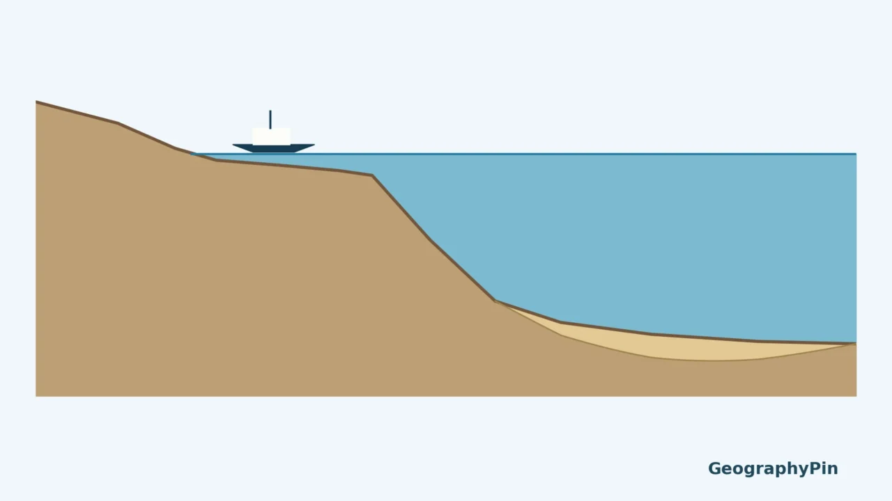
2. Read the Continental-Margin Diagram
Start at the coast and follow the seabed
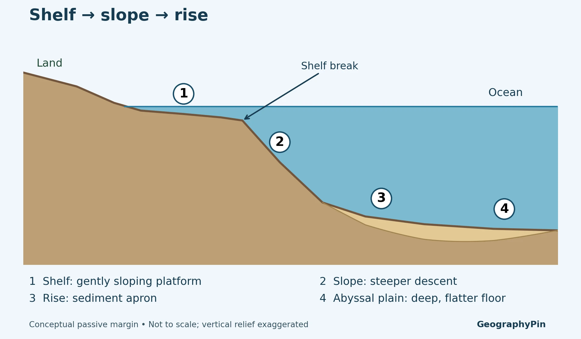
- Shelf: the seabed slopes gently away from land beneath relatively shallow water.
- Slope: after the shelf break, the seabed descends more sharply.
- Rise: a gentler sediment apron occupies the transition at the slope’s base.
- Abyssal plain: the deeper floor is comparatively flat in this simplified view.
The shelf break marks a change in gradient, not the shoreline. Water lies above both sides of it. On a bathymetric map, which shows underwater depth, you would look for a transition in the spacing and pattern of depth contours rather than simply searching for a change in the color of the water.
Do not calculate a slope angle from this drawing. Educational cross-sections often exaggerate vertical relief so the features remain visible. A real angle or distance requires surveyed depths and the horizontal scale. GeographyPin’s topographic-profile guide explains why comparing vertical and horizontal scales matters.
3. Why Real Margins Are More Complicated
Passive margins provide a useful starting example
The U.S. Atlantic coast illustrates the classic passive-margin sequence described by the National Park Service: coastal plain, broad shelf, slope, rise and abyssal plain. “Passive” refers to the margin’s tectonic setting away from an active plate boundary. It does not mean currents stop, sediment no longer moves or the seafloor cannot change.
At other margins, tectonics and sediment supply produce a different arrangement. A well-developed continental rise is not universal. The United Nations’ technical continental-shelf guidelines explicitly allow for a slope that meets the deep-ocean floor where no rise has developed. Do not force a labeled rise onto every cross-section merely because a classroom diagram includes one.
Canyons cut across the simple pattern
A smooth regional profile hides local valleys and ridges. NOAA’s account of the U.S. Atlantic margin describes submarine canyons that incise the shelf and slope and help connect shallower areas with deeper sediment deposits. Hudson Canyon is a named example extending from the shelf toward the deep continental rise.
Sediment does not simply fall straight down from the sea surface and stay where it lands. Gravity-driven flows and bottom currents can move it along or across the margin. USGS research on the eastern U.S. continental rise identifies bottom-current transport and deposition, showing why a rise can contain a complicated sedimentary record rather than one uniform layer.
Use the shelf–slope–rise sequence as an organizing framework, then check actual bathymetry for the place in question. A profile that crosses a canyon will differ from one drawn across the adjacent ridge even though both lie within the same continental margin.
4. Physical Shelf vs Legal Continental Shelf
The same words can answer a different question
In physical geography, the shelf is the relatively shallow platform before the slope. In the law of the sea, “continental shelf” describes a coastal state’s seabed and subsoil entitlement under legal rules. These meanings should not be exchanged without explanation.
Article 76 of the United Nations Convention on the Law of the Sea defines the legal shelf using natural prolongation and distance criteria. Its definition can extend beyond the shallow physical shelf. Establishing an outer limit beyond 200 nautical miles (about 370 km) involves additional criteria and procedures; the number is not a simple way to locate the shelf break on a depth map.
The legal concept concerns seabed and subsoil, not a claim that the entire overlying water column is part of a shallow shelf. This article does not map national maritime entitlements or resolve overlapping claims. Its diagram illustrates landforms only.
A useful reading habit is to ask what a source is measuring. A geology diagram may label a shelf break; a legal document may define a continental-shelf limit; a navigation chart may show depths and hazards. All concern the sea, but they are not interchangeable boundaries.
Frequently Asked Questions
Is the continental shelf part of the ocean floor?
Yes. It is submerged seabed beside a continent. Being underwater does not automatically mean that a feature belongs to the deep-ocean basin.
Does every continental margin have a rise?
No. A rise is a sediment-covered transition where one develops. Some slopes meet the deep-ocean floor without a well-developed rise.
Is the continental slope a vertical underwater cliff?
No. It is the steeper regional descent beyond the shelf. Local canyon walls may be very steep, but a schematic profile should not be read as a measured cliff angle.
Is the shelf break a country’s maritime boundary?
Not by itself. It is a physical change in seabed gradient. Maritime limits are defined through legal rules and cannot be inferred from that feature alone.
What Did We Learn Today?
Read the continental margin by its changing shape: a gentle shelf, a steeper slope and, where present, a sediment apron called the rise. Real margins include canyons and other irregularities, so the classic sequence is a starting model rather than a universal template. Keep physical landforms separate from the legal meaning of continental shelf.
Sources & Data Notes
- NOAA: Ocean Floor Features: shelf, slope and bathymetric context.
- USGS South Carolina Coastal Erosion Study glossary: physical shelf and margin definitions.
- National Park Service: Passive Continental Margins: U.S. Atlantic example and classic profile.
- NOAA: Exploring Canyons Along the Atlantic Margin: canyons and sediment pathways.
- USGS: Sediment Data from the Continental Rise: bottom-current transport and deposition.
- UN Commission on the Limits of the Continental Shelf guidelines: slope-to-rise or slope-to-deep-floor terminology.
- UNCLOS Part VI, Article 76: legal continental-shelf definition.
The original illustration is conceptual, not traced from a survey or another organization’s artwork. It shows one idealized passive-margin arrangement with exaggerated vertical relief. No fixed shelf width, universal shelf-break depth, measured sediment thickness or national boundary is inferred from it.