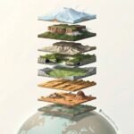
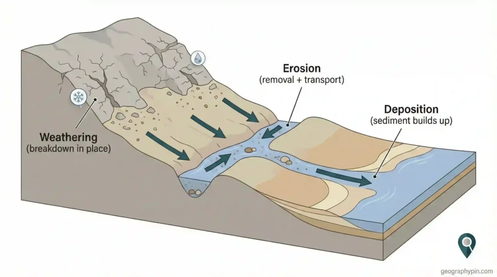
A cliff face that looks freshly cut, a valley narrowed into a gorge, a desert ridge shaped like it’s been sanded into alignment—erosion leaves signatures you can read once you know what to look for. Erosion is not just “rock breaking down”; it’s the removal and transport of material by water, wind, ice, gravity, or dissolving groundwater. This matters because the same processes that carve dramatic scenery also shape hazards, soils, coastlines, and where rivers and roads can realistically go.
Landforms created by erosion are features carved as moving water, waves, wind, ice, gravity, or dissolving groundwater removes and carries away rock and soil. Rivers cut valleys, gorges, canyons, and waterfalls; waves carve sea cliffs, caves, arches, and stacks; wind sculpts yardangs and ventifacts; glaciers create U-shaped valleys, cirques, and fjords; dissolution forms karst caves and sinkholes.
How to use this article: If you want quick recognition, start with the fast check. If you’re mixing up terms, use the comparison table. If you care about one environment (coasts, deserts, glaciers), jump in the river, coastal, or glacial sections. For quick answers, head to FAQ.
What counts as an erosion landform?
An erosion landform is a shape created because material was taken away. That sounds obvious, but it’s where people get trapped: many landscapes are a mix of erosion and deposition at the same time. A river can cut a steep valley upstream and lay down sandbars downstream. A coastline can lose a headland to wave attack while building a beach in the next bay. So the question is not “Is erosion happening?”—it’s “Is the defining feature carved by removal?”
Erosional landforms usually show one of these signals: steep faces (cliffs, gorge walls), scoured channels (canyons, plunge pools), undercut edges (sea caves, river cut banks), or streamlined rock shapes aligned with flow (yardangs, roche moutonnées). They also tend to expose fresh rock more often than depositional landforms do. If a feature looks like a surface has been shaved back, hollowed out, or sliced open, you’re usually looking at erosion as the main architect.
Fast check: quick ID signs of erosion landforms
- Steep or vertical walls that look cut (gorges, sea cliffs, cirque headwalls).
- Undercutting at a base (wave notches, river cut banks, waterfall plunge zones).
- Scour marks or polished surfaces (glacial striations, river-smoothed bedrock, wind-faceted stones).
- Directional shaping aligned with flow (yardangs with wind, roche moutonnées with ice).
- Hollows and voids where rock is removed by solution (karst caves, sinkholes).
Comparison: erosion vs weathering vs deposition (what to say correctly)
If you want clean writing and clean thinking, keep these terms separate. Weathering is breakdown in place. Erosion is removal and transport. Deposition is the drop-off and build-up of sediment. Most landscapes are a chain reaction: weathering creates loose material, erosion moves it, deposition stores it. When you label landforms, focus on the dominant action that built the visible shape.
| Process | What happens | Typical landform result |
|---|---|---|
| Weathering | Rock breaks down or weakens in place (physical or chemical) | Loose regolith, weakened cliffs, soil production (not “carved” shapes by itself) |
| Erosion | Material is detached and transported away by an agent | Valleys, gorges, sea caves, yardangs, cirques, karst voids |
| Deposition | Sediment is dropped and accumulates | Deltas, dunes, beaches, floodplains, alluvial fans |
The processes that carve landscapes
Erosion is a family of processes, not one tool. A river can pry rock loose with force (hydraulic action) and then grind it down with transported sediment (abrasion). Waves can hammer a crack until it opens, then throw sand and pebbles into the same spot like a drill. Ice can scrape bedrock like sandpaper and also pluck blocks out along fractures. In karst, groundwater dissolves rock and quietly removes it from below, shifting drainage underground.
It’s also useful to separate two steps: detachment (material breaks free) and transport (material is carried away). Detachment without transport gives you piles of debris that can temporarily protect a surface. Transport without detachment means an agent is moving but not doing much carving. The most dramatic erosion landforms form where both steps stay efficient over time—fresh rock is repeatedly exposed and cut again.
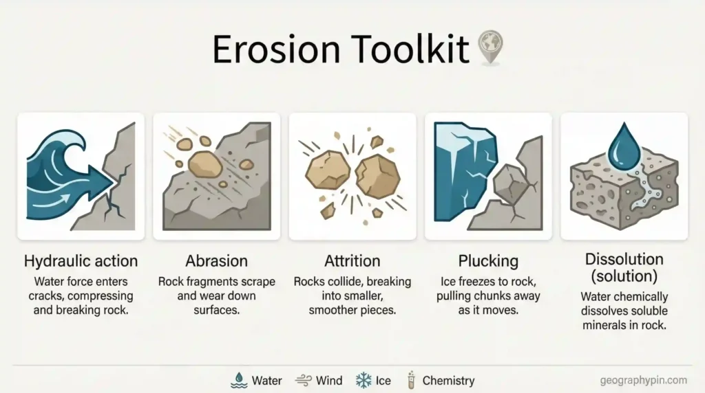
Mechanical erosion (force + abrasion)
Mechanical erosion is carving by force and scraping. Hydraulic action is the push and pressure of moving water or waves against rock, especially in cracks. Abrasion is the grinding effect of sediment: sand, pebbles, and cobbles are the cutting tools. Attrition is sediment grinding itself down as particles collide—this doesn’t carve the bedrock directly, but it changes the “tool sharpness” of a river or surf zone over distance. In glaciers, abrasion is amplified because rock fragments can be embedded at the ice base and dragged across bedrock.
Chemical erosion (solution + weakening)
Chemical erosion removes rock by dissolving it or altering minerals so the rock loses strength. The classic setting is carbonate rock (limestone and dolomite), where mildly acidic water can enlarge joints and bedding planes into conduits, creating caves and sinkholes. Chemical change also matters outside karst: if a rock mass develops a weakened layer (for example, along a clay-rich zone), slopes can fail more easily and mechanical erosion speeds up. The big point: erosion can be loud (waves) or silent (groundwater), but both can leave clear landforms.
River and runoff erosional landforms (fluvial)
Flowing water is the most widespread erosional agent on land because gravity keeps it moving, and water can carry sediment as a cutting load. Fluvial landforms are not only “in the river channel.” They include tributaries extending headward, runoff dissecting slopes into rills and gullies, and valley sides collapsing as rivers undercut them. When the system can keep clearing debris, incision stays active and landforms become sharper and deeper.
A simple way to sort river landforms is by the dominant direction of erosion. Vertical incision tends to produce narrow valleys, gorges, and canyons. Lateral erosion (side-to-side cutting) widens valleys and creates cut banks in meanders. Rivers switch between these modes depending on slope, sediment supply, rock strength, and changes in base level. That’s why a single river can show very different landforms along its course.
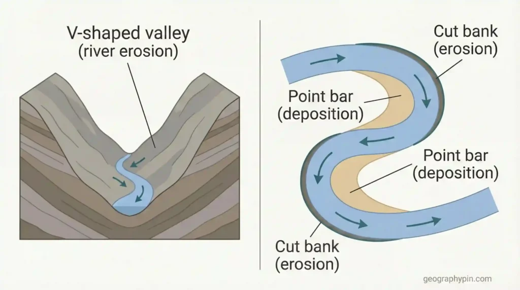
V-shaped valleys, gorges, and canyons
V-shaped valleys are the classic product of river incision combined with slope processes feeding material into the channel. In uplands, a river cuts down and steepens valley sides; gravity and weathering respond by sending rockfall and soil downslope. If the river can remove that material, the valley stays steep and narrow. When incision is intense and rock is resistant, the result can be a gorge: a deep, narrow cut with cliff-like walls. Canyons are similar in appearance but often develop in plateau settings where a river slices into layered rocks, sometimes leaving tall steps and benches where different layers resist erosion differently.
Waterfalls and knickpoints
Waterfalls are erosional features built around a break in slope called a knickpoint. A common setup is hard rock over softer rock: the softer layer erodes faster, forming a notch, and the overlying layer collapses in blocks. This keeps the waterfall steep and can shift it upstream over time. Even without a dramatic fall, knickpoints show up as rapids, stepped profiles, or abrupt narrow reaches where erosional energy is concentrated. When you see a waterfall, you’re basically seeing “erosion focused into a short distance.”
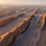
Badlands, rills, and gullies
Not all fluvial erosion is a single river channel. In dry or sparsely vegetated terrain, runoff can carve dense networks of small channels: rills (small) and gullies (larger and more persistent). Badlands are an extreme form of this dissection, often forming in weak sediments where short, intense storms cut the surface faster than vegetation can stabilize it. The landform signature is a tight branching pattern of ravines, sharp ridges between them, and slopes that look finely “cut up.” It’s erosion as surface geometry—lots of edges, lots of relief, and very little smoothness.
Coastal erosional landforms (wave erosion)
On rocky coasts, waves concentrate energy into a narrow strip where rock is repeatedly loaded, pressured, and hit by moving sediment. The shoreline is small in area, but the work can be relentless: undercutting at the base, collapse from above, and debris removal that “resets” the cliff face for the next cycle. If the surf zone is supplied with sand and pebbles, abrasion adds a grinding effect that can widen caves and deepen notches.
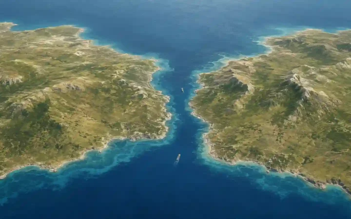
Coastal erosion also follows geology. Fractures and bedding planes act like pre-cut lines, so many sea caves and notches align with weaknesses rather than forming randomly. Where resistant rocks stand next to weaker rocks, the coast often sorts itself into headlands and bays: weaker rock retreats faster into embayments while stronger rock forms protruding points that take the main wave impact.
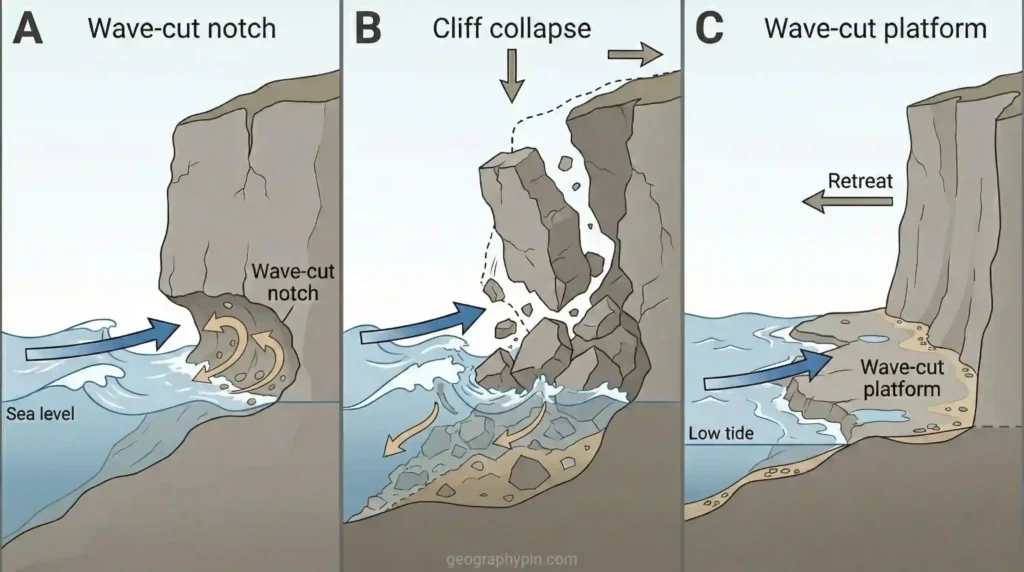
Sea cliffs and wave-cut platforms
Sea cliffs form when waves remove support at the base of a slope. The key move is undercutting: a notch develops, the cliff overhang becomes unstable, and blocks fall. If wave energy is high enough, the debris is broken up and carried away, allowing undercutting to continue. Over time, the retreating cliff can leave a relatively flatter rock bench near sea level called a wave-cut platform. These platforms are often rough, stepped, and fractured because they reflect both rock structure and repeated wave abrasion.
Sea caves, arches, stacks, and stumps
Where waves attack a fracture zone, a sea cave can enlarge by hydraulic pressure and abrasion. If erosion cuts through a headland, an arch can form. Arches are temporary: once the roof becomes too thin or too cracked, it collapses and leaves a sea stack, an isolated rock pillar offshore. As the stack is lowered, it can become a stump closer to the platform level. This sequence is common enough to be a “standard story,” but it depends heavily on rock type and fracture geometry—some coasts retreat without producing clean arches and stacks because failures happen as larger slabs instead of narrow sculpted pillars.
Wind-shaped erosional landforms (aeolian)
Wind erosion is most effective where vegetation is sparse and the surface supplies loose particles. It works in two main ways. Deflation removes fine dust and sand, sometimes lowering the surface and leaving behind a coarse “lag” that is harder to move. Abrasion uses wind-blown sand as a cutting tool, sandblasting exposed rock and shaping it into faceted, streamlined forms. This is why wind erosion often has a directional look: landforms align with the prevailing wind because the sand is arriving from a consistent angle.
People often associate deserts with dunes, but dunes are depositional. Aeolian erosion landforms are better identified by sculpted rock or consolidated sediments: ridges that look combed into parallel lines, stones with sharp faces, and surfaces polished near ground level where sand grains hop and strike most frequently. If you see an outcrop that looks “machined” into the wind direction, aeolian abrasion is a strong suspect.
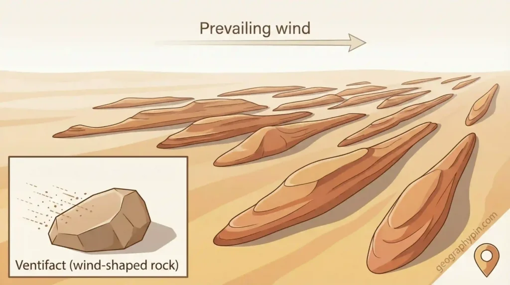
Yardangs and ventifacts
Yardangs are elongated ridges carved from softer bedrock or consolidated sediments, separated by grooves where erosion removed material more efficiently. They often form in fields, creating a repeated pattern that can be striking in satellite imagery. Ventifacts are rocks shaped into flat faces and sharp edges by sandblasting, sometimes showing multiple facets as wind directions vary over long periods. In both cases, the landform is telling you something about persistent wind exposure and available abrasive sediment.
Deflation hollows and desert pavement
Deflation hollows form when wind preferentially removes fine sediment from a patch of ground, leaving a shallow depression. Over time, the remaining gravel can concentrate at the surface as a protective layer called desert pavement. This is a good example of how erosion can slow itself down: once a surface becomes armored, further deflation becomes harder. The visible landform—hollow plus pavement—shows both removal and the landscape’s attempt to stabilize afterward.
Glacial erosional landforms (ice)
Glaciers reshape terrain in a different way than rivers because ice can fill a valley wall-to-wall and erode across a broad bed. Two processes dominate: abrasion (rock fragments embedded in the ice grind the bedrock) and plucking (ice removes blocks along fractures, especially where meltwater refreezes and locks onto rock). The result often looks widened, deepened, and smoothed—then suddenly over-steepened where headwalls and valley sides were undercut.
Glacial erosion is sensitive to where ice is thick and moving. Basins and valley heads can see concentrated erosion, while ridges and thin-ice areas may be less modified. That patchiness can leave landscapes with dramatic contrasts: sharp arêtes next to broad troughs, cirque bowls above steep rock steps, and bedrock knobs scoured into a directional shape that records ice flow.
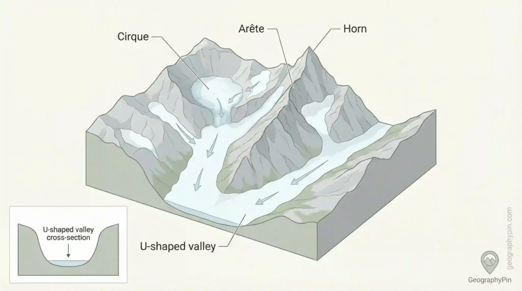
U-shaped valleys and fjords
A river valley is usually V-shaped because water is concentrated in a narrow channel. A glacier can occupy the entire valley width and erode both the floor and the sides, producing a U-shaped valley with steep walls and a broader bottom. When a glacially carved valley extends below sea level and later fills with seawater, it becomes a fjord. The fjord’s water is marine, but the valley shape is primarily an erosional product of ice carving.
Cirques, arêtes, horns, and roche moutonnées
Cirques are bowl-shaped hollows at valley heads, often where glaciers begin. As ice and freeze-thaw processes work the headwall, cirques can grow deeper and steeper. When cirques eat back into a ridge from different sides, the ridge narrows into an arête. Where several cirques encircle a peak, the leftover summit can become a horn. At smaller scales, roche moutonnées—bedrock knobs with a smooth up-ice side and a rough plucked down-ice side—record the direction of ice movement in a way that’s hard to mistake.
Karst and chemical erosion landforms (dissolution)
Karst landscapes are carved by chemical removal of rock, most commonly in limestone and dolomite. Water picks up carbon dioxide from the atmosphere and soil, becoming mildly acidic; over time it can dissolve carbonate rock along fractures and bedding planes. The key difference from most surface erosion is that drainage may shift underground. Streams can sink, flow through cave systems, and reappear at springs, leaving a surface that looks oddly “punctured” by depressions and sink points.
Karst erosion can produce landforms that feel almost engineered: caves that follow rock layers, sinkholes that form circular basins, and dry valleys where water used to flow on the surface but now travels below. It also matters for stability and planning. In active karst, voids and weakened roofs can collapse, and changes in groundwater conditions can trigger sudden failures. That risk component is not separate from the landform story—it is part of how chemical erosion reshapes the ground.
Caves and sinking streams
Caves begin as enlarged fractures and small conduits that gradually widen as water dissolves rock. Once a pathway becomes efficient, it can capture more flow, accelerating enlargement. Surface streams may disappear into swallow holes and re-emerge at springs, sometimes leaving dry surface valleys behind. The cave void itself is the erosional landform: rock has been removed in solution and transported away as dissolved material.
Sinkholes (dolines): gradual solution vs collapse
Sinkholes can form gradually as solution lowers the surface, or suddenly when a roof collapses into an underground void. The collapse style is the one people fear because it can be abrupt. Not every sinkhole is purely “natural” in the narrow sense—leaking infrastructure, groundwater pumping, and construction can trigger collapse in susceptible rock—but the presence of sinkholes is still a marker of a landscape where erosion is happening from below as well as from above.
How to recognize erosion landforms on maps and in the field (practical)
Start with geometry. On a topo map, tightly packed contour lines usually mean steep terrain—common for gorges, cliffs, and cirque headwalls. A river canyon often shows a narrow, deeply incised line with abrupt contour crossings. A glacial trough tends to show a broader valley floor with steep sides, often with hanging valleys feeding into it. On coasts, look for a sharp cliff line paired with a flatter bench near sea level—often a clue for a wave-cut platform.
Then use context clues. Yardangs and other wind-sculpted ridges often appear in repeated parallel patterns aligned with prevailing winds; they are easier to spot in satellite imagery than in a single ground photo. Karst clues include closed depressions, disappearing streams, and spring resurgence zones. In the field, pay attention to surfaces: undercut notches, fresh scarps, polished rock faces, faceted stones, or scratched bedrock can each point to a specific erosional agent. And keep safety in mind: sea cliffs and gorge walls fail without warning, and sinkhole-prone karst can be unstable even when it looks calm.
Common myths and mistakes
- Calling dunes “erosion landforms” when dunes are primarily depositional; wind erosion is more about yardangs, ventifacts, and deflation surfaces.
- Using “weathering” as a synonym for erosion; weathering prepares material, erosion removes and transports it.
- Assuming all canyons require constant big rivers; many are cut by a mix of long-term flow and short high-energy events, with slope failures doing a lot of wall work.
- Thinking the sea “built” sea stacks; stacks are leftovers after erosion removes surrounding rock and collapses arches.
- Treating sinkholes as only a human problem; human triggers exist, but many sinkholes reflect natural dissolution and subsurface erosion in karst.
FAQ
What is the simplest definition of an erosion landform?
An erosion landform is a landscape feature mainly shaped because material was removed and carried away—by water, waves, wind, ice, gravity, or dissolving groundwater.
What’s the difference between a gorge and a canyon?
The terms overlap in everyday use. A gorge often implies a narrower, steep-walled cut, while canyon is commonly used for larger, deeper valley cuts, especially in plateau terrains with exposed rock layers. The boundary isn’t a strict measurement.
Are waterfalls erosional or depositional features?
Waterfalls are mainly erosional because they concentrate hydraulic force and abrasion at a steep drop, undercutting rock and often retreating upstream. Deposition can happen nearby, but it doesn’t define the waterfall.
Do beaches count as landforms created by erosion?
Beaches are primarily depositional landforms. They often sit next to erosional landforms (like sea cliffs) and can be supplied by eroded material, but the beach itself is built by sediment accumulation.
Can wind really carve solid rock?
Yes, when sand is available as an abrasive tool. Wind-driven grains can sandblast surfaces, shape faceted stones (ventifacts), and help sculpt streamlined ridges (yardangs), especially in dry areas with sparse vegetation.
Are fjords made by glaciers or the sea?
Fjords are carved mainly by glaciers as deep valleys. The sea later floods the trough after ice retreats. The carving is glacial erosion; the water filling is a later coastal step.
What Did We Learn Today?
- Erosion landforms are defined by removal and transport of material, not just breakdown.
- Rivers carve V-shaped valleys, gorges, canyons, and waterfalls through incision and abrasion.
- Waves create sea cliffs, platforms, caves, arches, and stacks through undercutting and collapse.
- Wind erosion shows up in carved rock forms like yardangs and faceted ventifacts, not just dunes.
- Glaciers reshape valleys into U-shapes and can carve cirques, arêtes, and fjords through abrasion and plucking.
- Karst landscapes are shaped by dissolution, producing caves and sinkholes and often shifting drainage underground.
Erosion is a record of energy meeting weakness—flow meeting fractures, waves meeting joints, ice meeting a valley floor. Once you recognize the signatures, landscapes stop looking random and start looking like evidence you can interpret.
Sources & Data Notes
For this article, I leaned mainly on national geological surveys (for definitions and process descriptions), university geomorphology references, and peer-reviewed geomorphology work covering rivers, coasts, wind erosion, glaciers, and karst. For “big picture” landform identification, remote-sensing resources (for example, NASA-style Earth observation explainers) are also useful. I avoided single-number claims about erosion rates or formation times because they vary widely by rock type, climate, vegetation, and land use; where numbers are needed, the best practice is to cite a specific study or agency dataset for a specific location and year.