Glacial erosion landforms are bedrock shapes carved by moving glacier ice. The trick is that ice erodes valley floors and walls at the same time, leaving signatures that look different from river-carved terrain. Learn the patterns, and you can often spot where glaciers once flowed—even in landscapes with no ice today.
Glacial erosion landforms are bedrock features carved by moving glacier ice. Abrasion grinds and polishes rock, while plucking removes blocks from fractured bedrock. Together they produce U-shaped valleys, fjords, cirques, arêtes, horns, hanging valleys, overdeepened basins, and striated outcrops—classic clues of past ice flow after glaciers retreat.
How to use this article: For quick recognition, start with the fast check. For tricky “is this really glacial?” cases, jump to common confusions. For side-by-side differences, use the comparison table. For short answers, go to FAQ.
What counts as a glacial erosion landform?
A glacial erosion landform is a bedrock shape made by glacier ice removing rock—smoothing it, gouging it, or quarrying blocks from it.
Quick boundary (erosion vs deposition):
- If it’s carved into bedrock (valleys, basins, grooves, polished surfaces) → erosion.
- If it’s piled sediment (moraines, drumlins, eskers, outwash) → deposition.
The phrase “glacial landforms” is sometimes used for both categories. This guide stays on the carved bedrock side, because that’s where features like fjords, U-shaped valleys, cirques, arêtes, horns, roche moutonnées, and striations fit best.
Fast check: how to recognize ice-carved terrain
The 60-second field checklist
Glacial signatures are strongest when you combine shape with context. A single clue can mislead. Two or three together usually don’t.
- Valley cross-section: broad floor + steep sides (a “U” or trough) rather than a tight “V.”
- Overdeepened basins: rock basins that later become lakes, or coastal inlets that look like drowned valleys.
- Smoothed bedrock: rounded “whaleback” surfaces and polish where ice and rock flour acted like sandpaper.
- Linear scratches and grooves: striations aligned in a consistent direction across multiple outcrops (best on hard rock).
- Abrupt steps: hanging side valleys or waterfalls where a smaller glacier joined a bigger one.
- Sharp ridges and pyramidal peaks: arêtes and horns where multiple glaciers cut back into a mountain.
A quick decision path (use this when you’re unsure)
- Start big: Does the main valley look like a trough (wide floor + steep walls) or a V-shaped river valley?
- Look upstream: Do you see cirques (bowls) at valley heads, or sharp ridges (arêtes) between basins?
- Look for “steps”: Are there hanging side valleys, waterfalls, or basin chains along the floor?
- Confirm on bedrock: Any polish, striations, grooves, or streamlined knobs that repeat across multiple outcrops?
- Decide confidence: One clue = “possible.” Two to three matching clues = “likely.” A full package = “very likely.”
Where to look (maps + satellite) when you’re not in the field
You can spot many glacial erosion landforms from above. This is especially useful for wide valleys, cirques, and basin chains.
- Topographic maps: wide valley floors; steep, even valley walls; bowl-shaped headwalls; abrupt “steps” where tributaries drop into a main trough.
- Hillshade / DEM views: cirque amphitheaters, sharp ridgelines (arêtes), and pyramidal peaks (horns) stand out clearly.
- Satellite imagery: a small river sitting in an oversized valley; strings of lakes in a valley; smooth, bare bedrock patches with consistent lineation.
Two “sanity checks” that prevent false positives
Check for a glacial neighborhood. Ice-carved landforms tend to cluster. A lone “U-shaped valley” with no other evidence nearby might be something else (tectonic valley, landslide-modified valley, or a river valley later widened by slope processes).
Check scale and continuity. True glacial abrasion/striations typically keep a consistent direction across several exposures. Random scratches on one boulder can come from rockfall, construction, or modern scraping.
Common pitfalls (fast):
- Don’t trust one smooth rock surface by itself. Weathering can mimic “polish.”
- Don’t trust one scratch. Look for the same direction repeating on nearby bedrock.
- Don’t call every scenic inlet a fjord. Confirm inland glacial evidence first.
How glaciers erode: abrasion, plucking, and overdeepening
Glaciers erode bedrock mainly in two ways:
- Abrasion is grinding. Rock fragments embedded in basal ice scrape the bed, producing polish, grooves, and striations.
- Plucking (also called quarrying) is block removal. Ice grips fractured bedrock and pulls pieces free, leaving rougher, steeper surfaces.
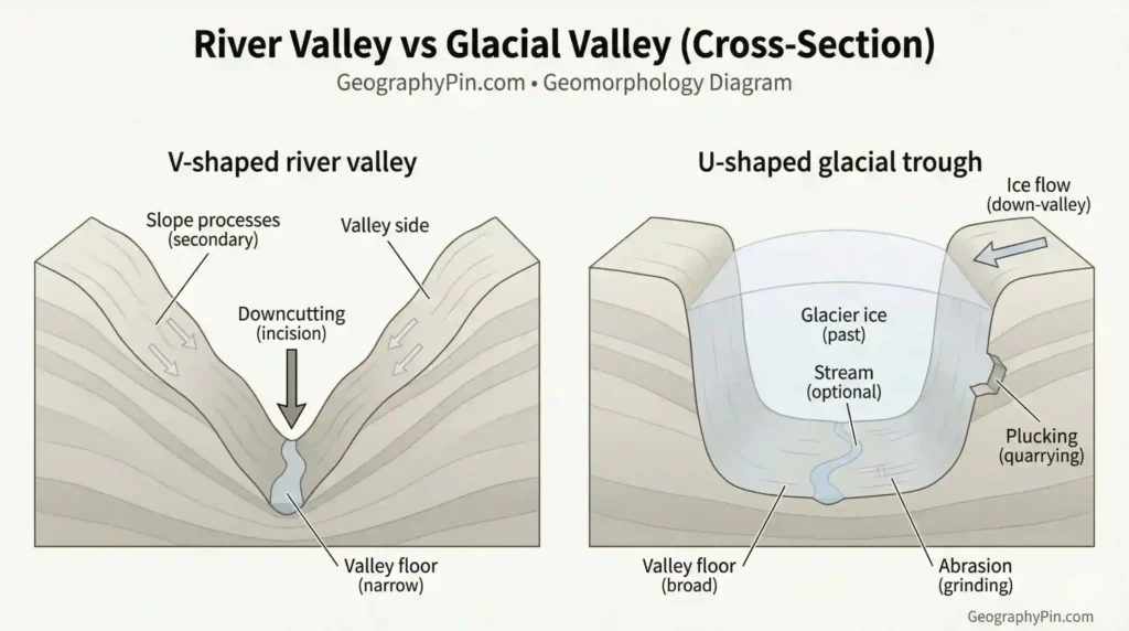
Ice can erode both down and sideways. Rivers usually concentrate erosion in a narrow channel, which favors V-shaped valleys. Thick ice spreads contact across a wider bed and presses against valley walls, which favors U-shaped troughs.
Some valleys and basins are overdeepened—cut deeper than their downstream outlets—because ice can be especially effective where it thickens, converges, or is forced through a constriction. After melting, these carved basins often become lakes. Along coasts, they can become flooded inlets.
Bedrock structure matters. Jointed, layered, or faulted rock tends to pluck into blocky steps. Massive, hard rock tends to show smoother abrasion and clearer striations.
Ice-carved landforms, explained
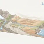
U-shaped valleys (glacial troughs) and truncated spurs
A classic glacial trough has steep walls and a broad, flatter floor. The sides often show truncated spurs—ridge ends that look “sliced off” where ice straightened and widened a formerly winding valley.
A good photo-based clue is mismatch: a small river occupying an oversized valley. The valley stays wide even where the channel is modest.
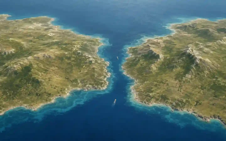
Fjords
A fjord is essentially a glacial trough that reaches the sea and is later flooded by seawater. Fjords often have steep rock walls and a long, narrow shape that matches former ice flow.
Not every narrow coastal inlet is a fjord. Some are drowned river valleys (rias) or tectonic inlets. The safer approach is to confirm inland glacial clues—U-shaped valleys, hanging valleys, polished bedrock, or streamlined knobs.
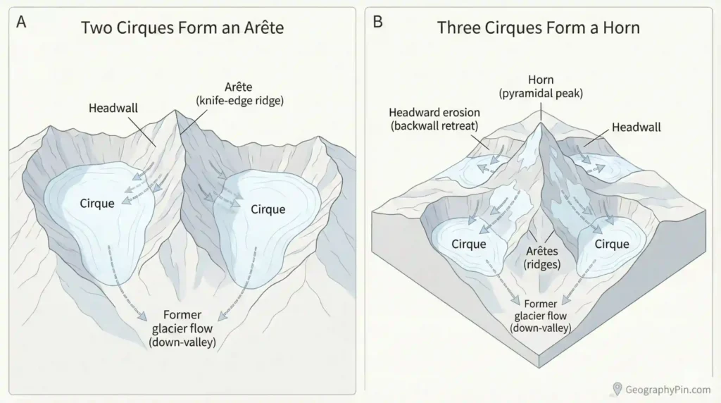
Cirques (corries/cwms) and tarns
Cirques are bowl-shaped hollows near the heads of mountain valleys—common birthplaces of small glaciers. After ice retreats, a cirque may hold a small lake called a tarn, sitting in a rock basin behind a bedrock lip.
Cirques often look like a natural “seat” in the landscape: steep backwall, gentler floor, and an opening that points down-valley.
Arêtes and horns (pyramidal peaks)
An arête is a sharp ridge formed when ice erodes on both sides of a ridge. A horn is a pointed peak left when three (or more) cirques cut back toward each other from different directions.
These are strong evidence of multi-directional ice erosion in alpine terrain: rock is being removed from several sides at once, leaving knife-edge ridges and sharp summits.
Hanging valleys
A hanging valley is a tributary valley left “perched” above a deeper main glacial trough, because the smaller tributary glacier cut down less than the main glacier. Streams from hanging valleys often enter the main valley as waterfalls today.
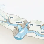
Roche moutonnées, whalebacks, striations, and polish
Roche moutonnées are streamlined bedrock bumps shaped by ice moving over them. The up-ice (stoss) side is typically smoother and more abraded. The down-ice (lee) side is often rougher where plucking removed blocks. When they occur in groups, they can preserve ice-flow direction like arrows across the landscape.
On hard bedrock, abrasion can leave glacial polish and striations—parallel scratches or grooves aligned with ice movement. They’re most convincing when the same direction repeats across multiple nearby outcrops.
Often-missed “micro-features” that make your identification stronger
These smaller signatures don’t replace the big landforms. They confirm them—especially when you’re deciding between “maybe glacial” and “very likely glacial.”
- Rock steps (riegels): bedrock “thresholds” that create steps along a valley floor. They often pair with basins upstream and waterfalls or rapids downstream.
- Chains of basins (paternoster-style lakes): a string of small lakes or ponds along a valley floor, often linked to overdeepened basins and rock steps.
- Valley shoulders: bench-like remnants along valley sides, marking older valley levels above the deeper glacial trough.
- Glacial grooves: larger, more obvious linear grooves than fine striations—best seen on exposed hard bedrock.
- Chatter marks / crescentic fractures: small curved “chipped” marks on bedrock created by tool-like clasts bouncing under ice.
- Knock-and-lochan topography: landscapes of ice-smoothed bedrock knobs (“knocks”) and water-filled hollows (“lochans”), common in strongly scoured bedrock terrain.
Look-alikes and common confusions
The most common mix-ups (and how to avoid them)
- Fjord vs ria: A ria is typically a drowned river valley. It often branches like a river network and may lack a consistently steep-walled trough inland. A fjord usually aligns with a glacial trough and pairs with inland glacial features.
- U-shaped valley vs tectonic valley: Fault-bounded valleys can be long and steep-sided too. Structural valleys often show strong straight-line control and fault-aligned margins, without the broader glacial “package” (hanging valleys, polished/striated bedrock, roche moutonnées, cirques upstream).
- Cirque vs landslide amphitheater: Landslides can create big bowl-shaped scars with steep headwalls. Cirques more often have a smoother basin form, and they cluster with arêtes and troughs in glaciated mountain terrain.
- Striations vs random scratches: True glacial striations tend to repeat in a consistent direction across multiple nearby bedrock exposures. Isolated scratches on loose boulders are much easier to misread.
- Roche moutonnée vs drumlin: A roche moutonnée is bedrock (erosion). A drumlin is typically sediment (deposition). Both can be streamlined in the direction of ice flow, which is why they’re often confused.
A practical rule: rely on packages, not single features
Glaciation is persuasive when multiple clues reinforce each other: trough + truncated spurs + hanging valleys, or cirques + arêtes + horn, or polished bedrock + repeated striation direction + roche moutonnées. If you only have one clue, keep a second explanation in mind until you see more evidence.
Glacial vs river vs coastal shaping: a comparison table
Quick comparisons you can use on maps or in the field
| Feature you see | Most typical shaper | What it tends to look like | Clues that strengthen the call | Common confusion |
|---|---|---|---|---|
| Wide valley with steep walls | Glacier ice | U-shaped trough; broad floor, truncated spurs | Hanging valleys, cirques upstream, roche moutonnées, polish/striations | Tectonic valley or widened river valley |
| Narrow valley with branching tributaries | Rivers and runoff | V-shaped cross-section; dendritic network | Active channel incision, terraces, point bars, consistent downstream narrowing | Glacial trough where the river is small |
| Long, narrow coastal inlet | Glacier (fjord) or river (ria) | Fjord: steep-sided trough; ria: branching drowned valleys | Fjord: inland U-shaped valleys and hanging valleys nearby; ria: river-like branching patterns | Calling every scenic inlet a fjord |
| Bowl-shaped hollow at a mountain head | Glacier ice (cirque) | Amphitheater basin; possible tarn | Clusters of cirques, arêtes, horns; clear down-valley trough | Landslide scar or volcanic crater |
| Smoothed bedrock knob with asymmetric sides | Glacier ice (roche moutonnée/whaleback) | Smooth stoss, rougher lee; streamlined profile | Consistent alignment with other flow indicators (striations, valley orientation) | Rounded hills from weathering |
| String of lakes/basins along a valley | Glacier ice (overdeepening + rock steps) | A chain of basins, often with abrupt steps between them | Trough shape, cirques upstream, polished/streamlined bedrock nearby | Karst lakes or dammed river lakes |
Real-world examples you can picture
Examples help because these landforms are easier to “see” once you’ve seen them in context. Here are safe, classic pairings (no risky rankings or numbers):
- U-shaped trough valleys: Yosemite Valley (USA) is a well-known classic glacial trough landscape.
- Fjords: Western Norway is the textbook region for steep-walled, ice-carved coastal inlets.
- Cirques + arêtes + horns: Many high alpine ranges (Alps, Rockies, Himalaya) showcase these “cut-from-multiple-sides” mountain forms.
- Scoured bedrock + knobs + hollows: Canadian Shield and parts of Scotland are famous for ice-smoothed bedrock with many rock basins.
Use these as visual anchors, then apply the identification checklist to your own region.
FAQ
Are fjords always made by glaciers?
The term “fjord” is generally used for a glacially carved valley that was later flooded by the sea. Many narrow inlets are not fjords, so it’s safer to look for inland glacial evidence (U-shaped valleys, hanging valleys, polish/striations) before using the label.
What’s the simplest difference between a U-shaped and a V-shaped valley?
A U-shaped valley is typically broad with steep walls and a flatter floor, because ice erodes the sides and bottom together. A V-shaped valley is typically narrower with a pointed cross-section, because rivers concentrate erosion in a channel.
Do you need striations to prove glaciation?
No. Striations are great when present, but they’re not everywhere. Many glaciated landscapes are identified from larger-scale shapes (troughs, cirques, arêtes, hanging valleys) plus supporting clues like polished bedrock or streamlined knobs.
Can glaciers create sharp peaks if ice is “soft”?
Yes—because the sharpness comes from where rock is being removed. When multiple glaciers erode a mountain from different sides, ridges can narrow into arêtes and summits can be left as horns as surrounding rock is cut back.
Is a roche moutonnée the same thing as a drumlin?
Not usually. A roche moutonnée is carved into bedrock (erosion), while a drumlin is typically built from sediment (deposition). Both can be streamlined in the direction of ice flow, which is why they’re often confused.
What does a hanging valley tell you about past ice?
It usually signals that a smaller tributary glacier joined a bigger trunk glacier. The main glacier cut deeper, leaving the tributary valley perched above the main trough after the ice melted.
What Did We Learn Today?
- Glacial erosion landforms are carved into bedrock, not built from dropped sediment.
- Strong identification uses packages of clues: troughs, cirques, hanging valleys, arêtes/horns, plus polish/striations where available.
- Abrasion smooths and scratches rock; plucking removes blocks—together they explain many “ice-only” shapes.
- Micro-features like rock steps, basin chains, grooves, and knock-and-lochan topography can confirm glacial erosion.
- Fjords are glacial valleys flooded by the sea, but not every narrow inlet is a fjord.
Sources & Data Notes
This guide follows standard geomorphology explanations commonly summarized by National Park Service-style public geology education pages, USGS-style glacier terminology glossaries, and widely used educational geology texts (including open educational resources). Because erosion rates and landform dimensions vary sharply by bedrock, ice dynamics, and glacial history, the article avoids hard numeric thresholds and focuses on shape-based diagnostics and cross-checking multiple field clues.
Suggested starting points (for deeper reading):
- USGS glacier and glaciation terminology glossaries (definitions and examples)
- National Park Service glacier and landscape interpretation pages (field recognition framing)
- University-level geomorphology open educational resources (abrasion, plucking, overdeepening concepts)
- National geological survey education pages (regional glaciation and landform interpretation)