Wind erosion landforms are the shapes left behind when moving air becomes a cutting tool—sand as sandpaper, dust as cargo, and bare ground as the workbench. This is about erosion (removal and sculpting), not wind-built landforms like dunes and loess, which are deposition.
One quick note on language: you’ll also see “aeolian” used for wind-driven processes in general (erosion and deposition). Here we’re staying tight on the “wind carving” side of the story.
Wind erosion landforms are features carved or sharpened when wind removes loose sediment (deflation) and blasts surfaces with moving grains (abrasion). You’ll recognize them by streamlined ridges, faceted stones, scoured hollows, and “armored” pebble surfaces—often where dry ground, sparse vegetation, and steady winds overlap.
How to use this article: Start with the 30-second field check if you’re trying to identify a landscape fast, then use the comparison table to separate erosion features from dunes. If you care about real-world impacts, jump to why it matters to people. For quick answers, go straight to FAQ.
What counts as a wind-erosion landform?
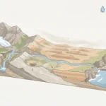
A wind-erosion landform is a feature shaped mainly by removal and scouring, not by piling material up. That includes ridges streamlined by blasting sand, stones that look cut by a grinder, and shallow basins where fine sediment has been carried away. In practice, wind erosion often works with other forces: rain loosens particles, temperature swings crack rock, and then wind does the transport and the polishing.
The easiest confusion is with wind deposition. Dunes and loess blankets are wind signatures too, but they’re built by accumulation. A landscape can contain both at once: wind may strip the finer dust from one patch (erosion) while stacking sand into a dune a short distance downwind (deposition). If you’re mapping what you see, think in verbs: “Is the wind taking away material here, or dropping it?”
30-second field check: is wind doing the cutting here?
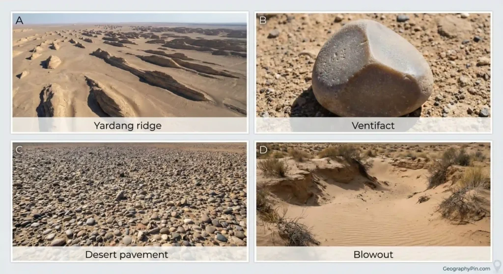
- Streamlined shapes: ridges or rock spines that look “combed” in one dominant direction (common in yardangs).
- Faceted stones: rocks with flat faces, sharp edges, or a “polished” sheen (classic ventifacts).
- Scoured hollows: shallow basins, blowouts, or bare patches where fines seem removed rather than washed away.
- Surface armor: a pavement of pebbles/cobbles sitting on top, with fewer fine grains at the surface (desert pavement).
- Context check: sparse vegetation + exposed sediment + recurring strong winds = wind erosion has room to work.
Wind-erosion landforms vs dunes and loess: same wind, different outcome
Wind can either carve or build, sometimes in the same basin. This comparison helps you avoid the most common misread: calling every wind-shaped feature a dune. If the surface looks armored, faceted, or scooped out, you’re usually looking at erosion. If you see rippled sand bodies, slip faces, or a blanket of fine silt, you’re in deposition territory.
| Feature you notice | More typical of wind erosion | More typical of wind deposition |
|---|---|---|
| Sharp-edged, flat-faced stones (ventifacts) | Abrasive “sandblasting” against stationary rock | Uncommon; deposits usually bury or cushion clasts |
| Streamlined bedrock ridges (yardangs) | Directional carving where rock/soil resists unevenly | Not a deposit form; dunes can align, but they’re mobile sand bodies |
| Pebble “armor” at the surface (desert pavement) | Deflation removes fines, leaving coarser lag behind | Some pavements get dust infill later, but the “lag” is erosion-driven |
| Bowl-shaped bare patch with steep edges (blowout) | Wind strips sand/soil after vegetation breaks | Downwind, that removed sand may feed a dune mound |
| Thick blanket of fine silt (loess) | Source area is often upwind erosion, not the landform itself | Classic deposition: wind-delivered silt builds soil parent material |
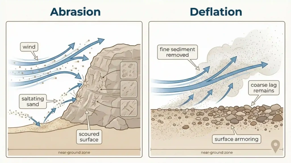
How wind erodes: abrasion, deflation, and saltation
Wind becomes a geomorphic force when it can both pick up sediment and keep it moving. The heavy lifting is often done close to the ground: sand grains hop and skip (saltation), nudging other grains forward and striking rock like a steady stream of tiny impacts. Over time, this can sharpen edges, etch grooves, and preferentially wear weaker layers.
Deflation is the removal side of the equation. Fine particles—especially silt and clay—can be lifted and carried away more easily than gravel. When that happens repeatedly, the surface “coarsens” and may end up protected by a lag of pebbles (desert pavement). Abrasion and deflation often team up: deflation exposes fresh material, abrasion scours it, and the cycle continues as long as supply and wind persist. Exact thresholds depend on grain size, moisture, crusting, and vegetation, so the most honest field rule is contextual: dry, loose, and bare surfaces are vulnerable; damp, crusted, or well-vegetated surfaces resist.

One detail that helps when you’re reading a landscape: wind erosion is rarely uniform. Obstacles create turbulence, gaps act like funnels, and dry lakebeds (playas) can supply huge amounts of fine material when they dry and crack. That’s why you may see sharp transitions over short distances—an armored surface next to a scoured patch, or a ventifact-rich zone beside a sandy deposit.
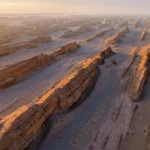
Signature wind-erosion landforms you can recognize
Some wind-erosion landforms are dramatic—long ridges carved into bedrock—while others are small enough to fit in your hand. The trick is to look for directionality and selective wear. Wind tends to repeat itself: prevailing directions carve repeated forms, and abrasion tends to be strongest near the ground where sand is concentrated.
Yardangs are streamlined ridges carved into consolidated sediment or softer rock, often aligned with prevailing winds. They can form whole “fields” where the surface material has just the right mix of weakness (to be carved) and strength (to hold shape). Ventifacts are the opposite scale: individual stones faceted by wind-driven sand. Some show multiple faces (“multi-faceted” forms) when wind directions shift seasonally or over longer periods.
Desert pavement looks like someone sorted the surface: pebbles and small stones on top, fewer fines at the surface. It’s often linked to long-term deflation and surface stabilization, though dust can later settle between clasts. Deflation hollows and blowouts are shallow depressions where sediment has been removed—blowouts especially where vegetation breaks and wind attacks exposed sand. Add in rock pedestals and undercut “mushroom” shapes in some settings, and you start to see a consistent theme: wind scours what’s weak, shields what’s coarse, and exaggerates contrasts.
A practical field cue: if you can identify a consistent “wind-facing” side (more pitted, more polished, more sharply cut), you’re usually dealing with abrasion. If the story is “missing fines” and an armored surface, you’re usually seeing deflation. Many places show both at once—wind is rarely polite enough to choose only one method.
Where wind erosion is strongest and why
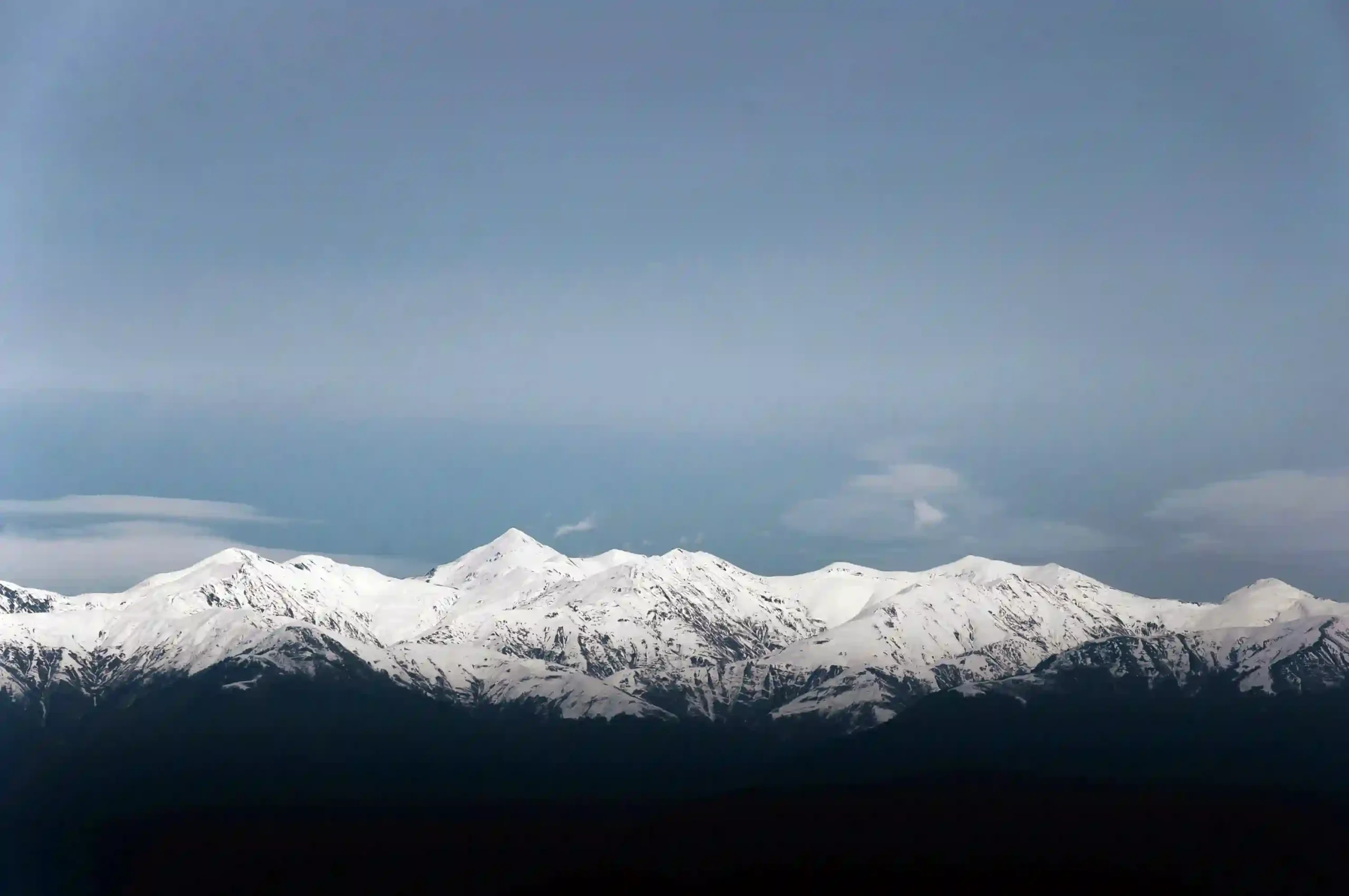
Wind erosion shows up where three conditions overlap: (1) available loose sediment, (2) enough wind energy, and (3) weak protection (little vegetation, low moisture, or fragile soil structure). Deserts are the headline setting, but dry landscapes outside classic deserts can qualify—semi-arid rangelands, coastal sand plains, and even high plateaus where surfaces dry out and plant cover is thin.
Playas and dry lakebeds are important because they can act as sediment factories when wet phases deposit fine material and dry phases leave it exposed. Basin-and-range topography, long open valleys, and passes can funnel winds, concentrating erosion along corridors. Human disturbance can also create “new” erosion hotspots: off-road tracks that break crusts, overgrazed patches, or construction areas that leave soil bare in windy seasons. On the flip side, surfaces can self-stabilize—armoring, crusting, or vegetation recovery can reduce erosion without the landscape looking greener from a distance.
If you’re thinking beyond Earth, wind-shaped erosion features are also discussed for Mars in planetary geology (NASA, various mission years). The key takeaway isn’t a direct one-to-one comparison—different air density, different sand movement dynamics—but the same basic logic: persistent winds plus movable particles can sculpt recognizable forms over time.
Why wind erosion matters to people
Wind erosion isn’t just a desert curiosity—it’s a practical problem because it moves soil and dust from places that need it to places that don’t. When fine particles lift, they can reduce visibility, irritate lungs, and carry salts or pollutants depending on what’s in the source sediment. The same process that sculpts a ventifact can also strip the most fertile portion of a field’s topsoil, especially where the surface has been loosened and left bare.
Infrastructure also feels it. Dust can clog filters and machinery, and drifting sand can overrun roads, rail lines, and channels. Even without dramatic sand drifts, constant fine dust can increase maintenance and shorten equipment life. In water-scarce regions, there’s an added layer: wind-blown dust can affect snowmelt timing on mountains by darkening snow surfaces, and it can deliver nutrients or contaminants into lakes and reservoirs—effects that vary widely by region and sediment chemistry, so careful local monitoring matters more than global generalizations.
There’s also a quiet cultural and economic dimension: communities in drylands often read wind the way coastal towns read tides. Seasonal wind patterns shape planting timing, livestock movement, road planning, and even building design (orientation, shelterbelts, courtyards). The landforms are the long-term memory of those patterns—written in stone, gravel, and missing dust.
Reducing wind erosion: what actually helps on the ground
Wind erosion control works best when it targets the two weak points: exposed soil and unbroken wind fetch (long distances of bare ground). The goal isn’t to “stop wind.” It’s to stop wind from getting a clean grip on loose particles. That usually means keeping some form of cover, roughness, or stability at the surface during the windiest periods.
In agricultural settings, common tools include residue retention (keeping crop stubble), cover crops, reduced or no-till systems where feasible, and timed field operations that avoid leaving fine soil exposed in peak windy seasons. Windbreaks and shelterbelts can reduce wind speed near the ground and interrupt transport, especially when designed to avoid creating strong turbulence at the edges. On rangelands, grazing management matters because vegetation loss and trampling can break soil crusts and expose fines. On roads and construction sites, dust suppression and surface stabilization—done responsibly for the local environment—often pays back quickly in safety and maintenance.
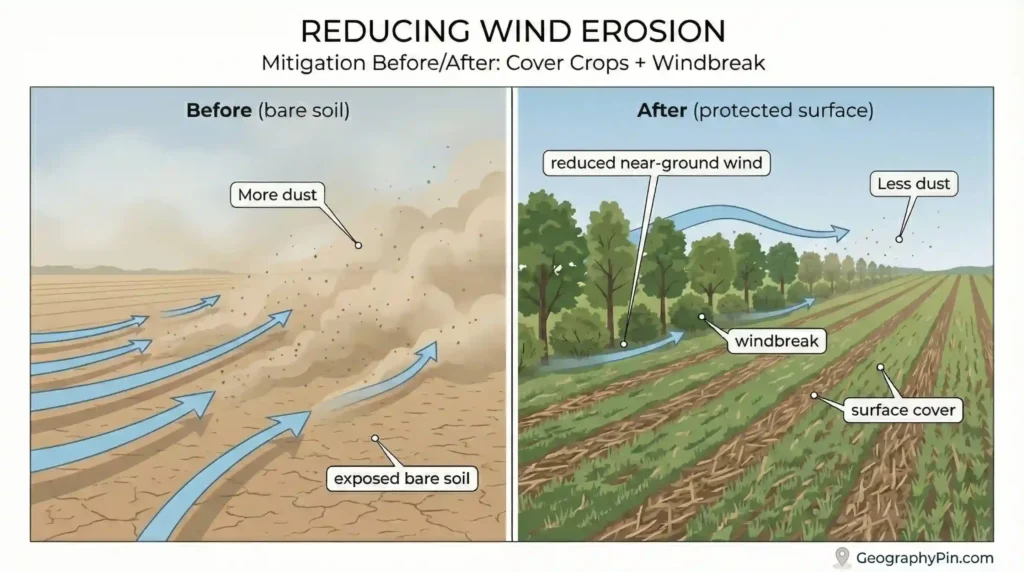
A realistic expectation helps: mitigation reduces frequency and severity; it doesn’t erase wind from a dry climate. Some places will still experience episodic erosion during droughts or after disturbance. That’s why many successful approaches are layered—surface cover, windbreaks, and soil-structure protection together—rather than one single fix.
Common myths and mistakes
Wind erosion gets misread in predictable ways—usually because wind can both carve and build, and because the most dramatic landforms steal attention. These are the mistakes that show up most often in field notes, photo captions, and casual explanations.
- Myth: “If it’s wind-shaped, it must be a dune.” Dunes are deposits; ventifacts, yardangs, and desert pavement are erosion signatures.
- Mistake: ignoring moisture and crusts. A surface that looks sandy can behave like cement after rain or when a crust forms; erosion risk changes fast.
- Myth: wind erosion only happens in “true deserts.” Semi-arid farms, coastal plains, and disturbed soils can erode badly when conditions line up.
- Mistake: assuming one wind direction forever. Multi-faceted ventifacts and complex yardang patterns can reflect shifting winds over seasons or longer spans.
- Myth: “More wind always means more erosion.” Sediment supply and surface protection often matter more than raw windiness.
If you want one clean habit: describe what you see first (facets, scours, armor, alignment), then propose the process (abrasion vs deflation), and only then talk about climate or human disturbance as the “why here.” That order keeps you honest.
FAQ
Are yardangs made only by wind?
Wind is usually the main sculptor, especially through abrasion and selective removal, but it often works on material that was prepared by other processes. Cracking from temperature swings, occasional water erosion, or sediment layering can create weaknesses that wind then exaggerates. The final shape is typically a wind-dominated signature in an environment where sediment can move.
What’s the easiest way to identify a ventifact?
Look for flat faces and sharp edges on a stone that don’t match fresh breakage. Ventifacts often have a consistent “windward” polish or pitting, and sometimes multiple faces if winds vary. Context matters: they’re most convincing where sand is available to act as the abrasive.
Is desert pavement “natural,” or is it caused by humans?
Desert pavement can form naturally through long-term deflation and surface stabilization, sometimes aided by dust settling and soil development between stones over time (national geological surveys, various years). Humans can damage it easily—vehicle tracks and heavy disturbance can break the protective surface and expose fine material, increasing erosion risk.
How fast do wind-erosion landforms form?
Timescales vary widely. Small features like fresh blowouts or localized scours can appear quickly after vegetation loss or disturbance, while large, landscape-scale forms like yardang fields reflect long-term repetition of favorable conditions. Because rates depend on wind regime, sediment supply, moisture, and rock/soil properties, broad “one-number” answers are usually misleading in the absence of site-specific studies.
Can wind erosion happen in cold dry places, not just hot deserts?
Yes. Any dry, exposed surface with movable sediment can experience wind erosion, including cold-steppe regions and polar deserts. Seasonal snow cover and frozen ground can change sediment availability, but when surfaces dry and winds are strong, abrasion and deflation can still shape landforms.
What’s one practical thing that reduces wind erosion without heavy engineering?
Keep the surface covered or rough during windy periods—crop residue, cover crops, or maintaining vegetation structure on rangelands. Even partial cover can break up near-ground airflow and reduce the ability of wind to lift and accelerate particles. Combine that with minimizing disturbance of crusted or armored surfaces, and you often get a noticeable reduction in dust and soil loss.
What Did We Learn Today?
- Wind erosion landforms are made by removal (deflation) and sand-driven scouring (abrasion), not by piling sand into dunes.
- Fast identifiers include streamlined ridges (yardangs), faceted stones (ventifacts), scoured hollows, and “armored” pebble surfaces (desert pavement).
- Wind erosion strengthens where loose sediment, persistent wind, and low surface protection overlap—deserts, semi-arid lands, playas, and disturbed soils.
- Erosion and deposition often coexist: the same wind can strip fines upwind and build dunes or loess downwind.
- For people, the stakes are dust, soil loss, visibility, and maintenance—plus long-term land productivity in dry regions.
Wind doesn’t need dramatic cliffs to reshape a landscape—it works patiently, close to the ground, one grain at a time. Once you train your eye to separate carving from piling, drylands start to read like a record of prevailing winds, sediment supply, and surface stability.
Sources & Data Notes
For this article, we leaned on national geological survey explainers and glossaries (USGS-style agencies and their equivalents), standard university geomorphology/aeolian-process notes, and peer-reviewed geomorphology papers that describe abrasion, deflation, and field examples (yardangs, ventifacts, desert pavement, blowouts). For “big picture” pattern recognition—like yardang fields, playas, and dust source regions—we relied on remote-sensing explainers and imagery-based overviews (NASA Earth Observatory–style resources). Where you see ranges or time-scale language, it’s because reported formation rates and wind thresholds change a lot by grain size, moisture/crusting, vegetation cover, and local wind regime, so we avoided one-number claims unless they’re tied to a clearly defined dataset and year.