Water erosion landforms are the shapes made when moving water removes rock or soil and carries it away. Rivers carve valleys and gorges. Storm runoff cuts rills and gullies. Floods reshape floodplains. Here, “erosion” means Earth-surface change. It does not mean tooth enamel erosion or wear inside pipes.
You can often spot water’s work without tools. Look for connected pathways downhill, uneven banks on bends, and fresh sediment where flow slows. The details vary by geology and climate, but the logic repeats.
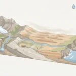
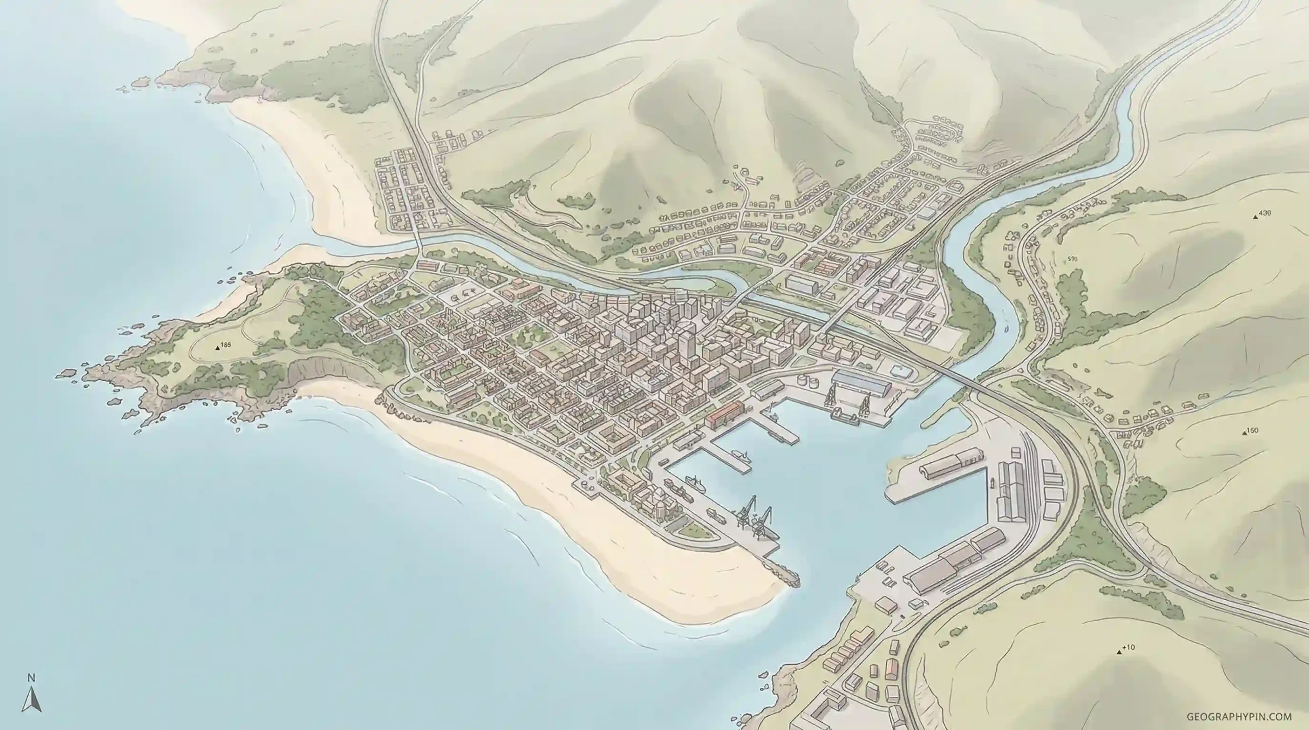
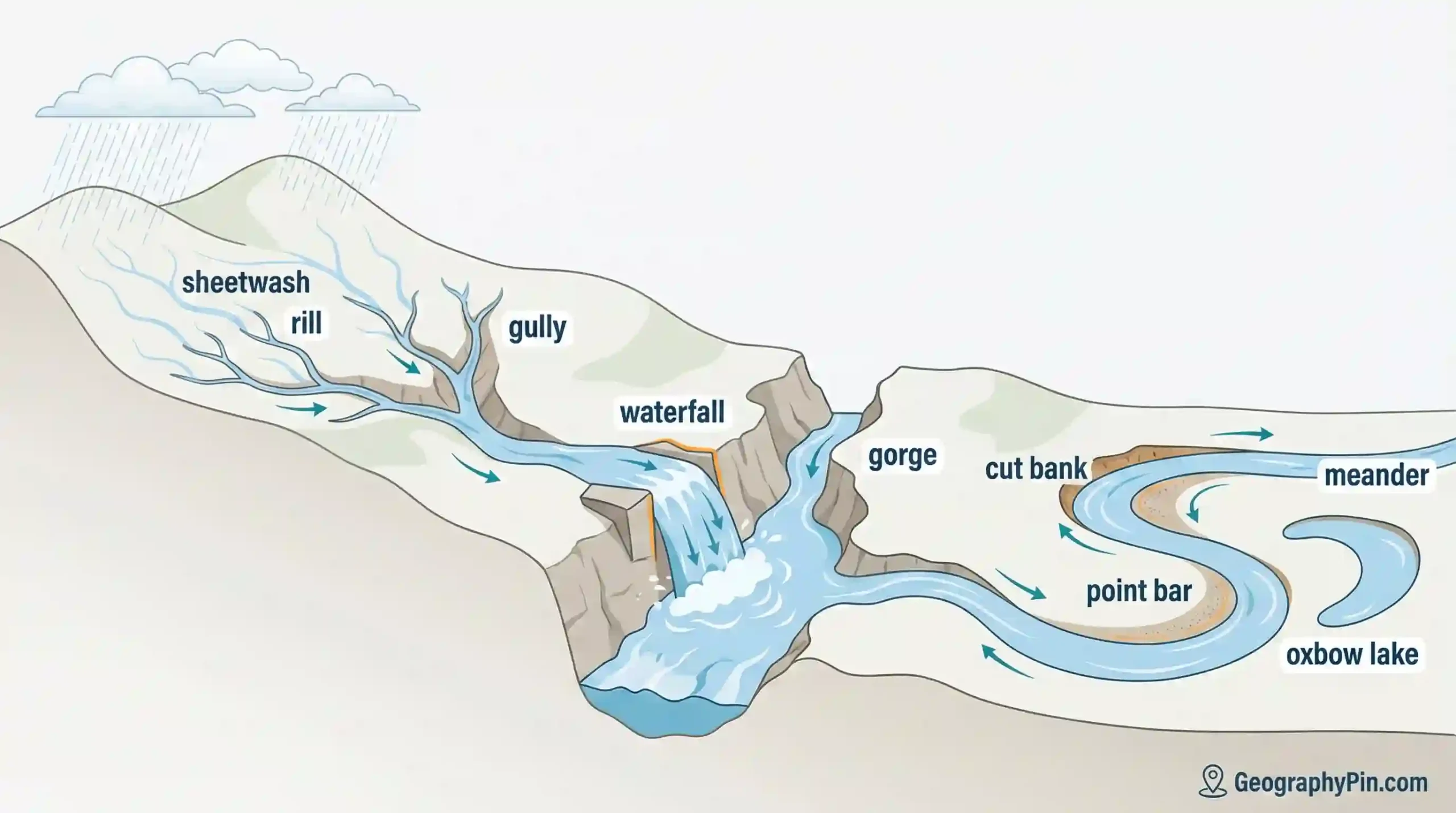
Water erosion landforms are features shaped mainly by flowing water from rivers and rainfall runoff—valleys, gorges, waterfalls, meanders, floodplains, rills, and gullies. They form when water loosens material, moves it downstream, and sometimes deposits it where flow slows. Slope, rock or soil type, and vegetation control the final shape (USGS, undated; soil conservation agencies, undated).
How to use this article: For fast identification, start with the quick ID checks. For “river vs runoff” confusion, jump to fluvial vs runoff. For look-alike landforms, use the comparison table. For short answers, go to FAQ.
What counts as a water erosion landform?
A water erosion landform exists because flowing water removed material from a surface. Flow can be steady in a river, seasonal in a stream, or short-lived during storms. Movement is the key. Still water can store sediment, but it usually does not do the cutting.
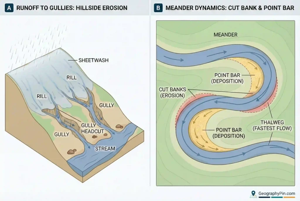
Many landscapes show mixed signals, so it helps to keep terms clean. “Erosion” is removal. “Deposition” is the drop-off. Rivers often do both, sometimes within the same bend. Runoff on slopes can also cut channels without a permanent stream. That’s why gullies can appear far from a river valley.
Fast check: signs you’re looking at water-driven erosion
- Downhill connection: small channels join larger ones, which feed a stream or river.
- Bend pattern: outside banks look steeper; inside banks often show fresh bars.
- Transport clues: rounded pebbles suggest water movement; sharp fragments suggest short travel.
- Storm “switch”: the feature runs only during rain, but it runs hard when it does.
- Surface marks: water favors channels and basins more than long, streamlined ridges.
Fluvial vs runoff erosion (plain language)
Fluvial erosion is river-and-stream erosion inside a channel. It includes bank undercutting, bed scouring, and waterfall retreat. Runoff erosion starts on the ground surface during rainfall. It begins as sheet flow, then concentrates into rills and gullies. Both can feed the same system, but they leave different-sized “tracks” and respond to different triggers (USGS, undated; soil conservation agencies, undated).
If a channel carries water most of the year, fluvial processes usually dominate. If flow appears only during storms, runoff processes are often the main sculptor. Many places sit in the middle, especially in dry climates with seasonal storms.
Water vs wind vs ice: quick comparison
Some landforms overlap, but the “fingerprints” are often different. Use this as a quick filter when a feature could be water-cut, wind-shaped, or ice-carved.
| Erosion agent | Typical shape clue | Common surface clue |
|---|---|---|
| Flowing water (rivers + runoff) | Branching channels; bends with uneven banks; valleys that often widen downstream | Rounded sediment; fresh bars; floodplain flats and abandoned bends |
| Wind | Streamlined ridges; dunes aligned with prevailing winds; deflation hollows | Sand sheets; ripples; abrasion faces; limited drainage integration |
| Ice (glacial) | Broad U-shaped valleys; cirques; overdeepened basins | Striations/polish; unsorted till; moraines as ridges |
How rivers and runoff actually erode
Water erosion is not a single action. It is a set of simple processes that repeat. Once you recognize the processes, the landforms stop feeling random.
The three main tools: force, scraping, dissolving
Hydraulic action is direct force. Flow pushes into cracks and loosens particles. Abrasion is scraping. Sand and gravel moving with the water grind banks and bedrock. Solution is chemical. Some minerals dissolve in water, which can weaken rock over time (USGS, undated).
Each tool matters more in certain settings. Fast, turbulent flow favors force. Sediment-rich flow favors scraping. Dissolving becomes important where the rock chemistry allows it. Many real channels combine all three.
Where most erosion tends to happen
High flow matters because water has more power when it moves faster and deeper. That usually means floods, snowmelt peaks, or storm pulses. Weak spots also matter. Think soft banks, fractured rock, sharp bends, and steep reaches. Those places focus energy, so they often change first (USGS, undated).
Runoff erosion has its own hotspots. Bare soil is a common one. Compacted ground is another. In both cases, water runs off instead of soaking in. Flow then gathers into thin lines, which cut deeper in the next storm (soil conservation agencies, undated).
Timescales: fast scars, slow carving
Small features can form quickly. Rills may appear after one intense storm. Gullies can deepen in bursts once a channel is established. Large valleys and gorges usually reflect many high-flow events over long periods, mixed with broader controls like uplift and sediment supply (national geological surveys, general guidance). Exact rates vary widely, so it is safer to treat time as “episodic” rather than steady.
River-channel erosion landforms
Rivers carve most efficiently where flow is confined and slope is higher. In uplands, streams often cut V-shaped valleys. In resistant bedrock, a river may incise into a narrow corridor and create a gorge or canyon. The words are not strict scientific categories. Both point to a deep cut with steep walls.
Rapids and steep step-like reaches often appear where rock layers change, where large boulders armor the bed, or where the channel crosses a structural boundary. These features can be stable for a while, then shift after a major flood. A calm surface at low flow does not tell the whole story.
Waterfalls and knickpoints: why drops form
Waterfalls and sharp drops often sit at knickpoints, which are abrupt changes in channel slope. A common cause is rock contrast, such as a hard layer over a weaker one. Faults can also create steps. Landslides can do it too, especially if debris temporarily blocks a channel (USGS, undated).
Below a waterfall, turbulent water can dig a plunge pool. In many settings, undercutting removes support and the drop shifts upstream. Local geology decides how clean that pattern looks.
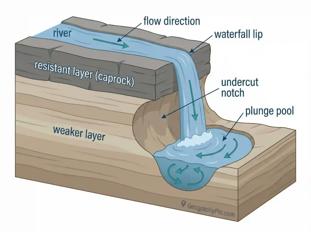
Rock type and structure: the hidden map under the river
Rock controls where a river can “give way.” Fractures and bedding planes act like ready-made lines of weakness. A river may follow them and produce straight channel segments. Softer sediment behaves differently. Banks can slump and widen the valley quickly. These contrasts help explain why neighboring rivers can look unrelated, even under similar rainfall.
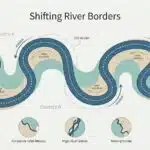
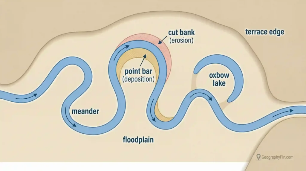
Meanders, floodplains, and river migration
On gentler slopes, many rivers shift from mainly cutting down to cutting sideways. That change creates the classic floodplain landscape: looping bends, sand bars, and old channel scars.
Cut bank vs point bar: a simple field read
At a bend, faster flow often hugs the outside bank. That bank becomes a cut bank and tends to be steeper. Slower flow often sits along the inside bank. Sediment settles there and forms a point bar. This pairing is one of the most reliable “live erosion” clues in a meandering channel.
Look for exposed roots, fresh slumps, or undercut edges on the outside curve. Then look for lighter sand or gravel on the inside curve. Young vegetation on a bar can also hint at recent deposition.
Oxbow lakes and cutoff bends
As meanders grow, two parts of the loop may approach each other. During a flood, the river can cut across the neck and create a shorter path. The abandoned loop may become an oxbow lake. If it dries, it may remain as a curved scar. These features are especially common in sediment-rich floodplains (national geological surveys, general guidance).
Floodplains vs terraces: what “flat” really means
A floodplain is shaped by floods. It may look flat, but it is not uniform. Subtle natural levees can sit near the channel. Wetter backswamps can sit farther out. A river terrace is different. It is an older floodplain surface left above the modern channel after the river cuts down. Terraces often reflect changes in sediment supply, climate, or uplift (national geological surveys, general guidance).
Rainfall-runoff landforms on slopes
Runoff erosion starts on the ground surface. It often begins as sheet flow. Then water concentrates into tiny channels. Those channels can expand with each storm, especially when soil is bare or compacted (soil conservation agencies, undated).
The early stages can be small. Rills are often on the scale of inches (centimeters) in depth and width, though size varies. Gullies are larger and more persistent. In many conservation systems, “gully” implies a channel that normal field smoothing will not remove (soil conservation agencies, undated).
Rill vs gully: the practical difference
Think of a rill as a first draft. It is a shallow channel that forms where runoff gathers. Think of a gully as the committed version. It is deeper, wider, and more likely to keep growing because it captures more flow. The transition matters because gullies can redirect drainage and accelerate soil loss.
Badlands and arroyos: when runoff dominates
Badlands develop where soft sediment meets sparse plant cover and repeated runoff. The result is a dense network of gullies and sharp ridges. In dry regions, storm flows can carve arroyos (ephemeral channels). These beds may stay dry for long stretches and then run hard during storms. Concentration is the key driver in both settings.
Vegetation and soil structure: why bare ground fails
Plants reduce erosion in several ways. Ground cover softens raindrop impact. Roots hold grains in place. Organic matter improves infiltration. Compaction does the opposite. It reduces infiltration and increases surface runoff. That is why fresh construction cuts, unprotected trails, and overgrazed slopes often show rills after storms (soil conservation agencies, undated).
Human fingerprints and erosion control
Human changes rarely erase erosion. More often, they relocate it. Channel straightening can speed water through a reach. Bank armoring can protect one bend and increase stress downstream. Drainage pipes can turn gentle sheet flow into a focused jet.
Channels, dams, and sediment: downstream adjustment
Dams commonly trap sediment. Downstream, the water may carry less sand and gravel than before. Some rivers then erode their beds or banks as they adjust to the new sediment balance (USGS, undated; national geological surveys, general guidance). Effects vary by dam operation, tributary inputs, and local geology, so it is better to think in tendencies than rules.
Practical fixes: slow, spread, protect
The most reliable erosion controls work near the source. Slow runoff before it concentrates. Spread flow across protected ground. Keep soil covered. Practical examples include buffer strips, contour planting, small check structures in minor channels, and stormwater outlets that discharge onto armored or vegetated surfaces (soil conservation agencies, undated).
Safety note for field visits
Undercut banks and gully edges can fail without warning, especially after rain. Treat steep rims and fresh walls as unstable. In arid regions, remember that a dry channel can flood quickly if storms hit upstream.
Common myths and mistakes
- “Everything near a river was carved by that river.” Slope runoff can shape nearby land without a permanent stream.
- “Erosion means only huge canyons.” Small rills and gullies can cause major soil loss and drainage change.
- “A calm river is not doing anything.” The biggest changes often occur during high-flow events.
- “Meanders are mistakes.” Many rivers migrate across floodplains as part of normal adjustment.
- “One photo explains the process.” Water erosion is often episodic, tied to storms and floods.
FAQ
Are water erosion landforms always made by rivers?
No. Rivers are a major agent, but rainfall runoff can carve landforms on slopes before water becomes a permanent stream. Rills, gullies, and ephemeral channels can form from short-lived storm flows (soil conservation agencies, undated).
What is the difference between erosion and deposition?
Erosion removes material from a place. Deposition drops material where flow slows. A single meander bend often shows both: erosion at the cut bank and deposition at the point bar.
How can I tell a river valley from a glacial valley?
Many river valleys are narrower and more V-shaped. Many glacial valleys are broader and U-shaped, and may show moraines or smoothed bedrock (national geological surveys, general guidance). Local geology can blur the pattern, so use multiple clues.
Do waterfalls always mean hard rock over soft rock?
Often, but not always. Rock contrast is common, yet faults, landslides, and volcanic flows can also create drops. Rivers can also develop knickpoints while adjusting to base-level change (USGS, undated).
Can gullies be “fixed” once they form?
They can often be stabilized, but results depend on size and setting. The core goal is to reduce concentrated runoff and protect the channel so it stops expanding. Vegetation recovery is usually part of the solution (soil conservation agencies, undated).
Why do some rivers cut canyons while others build wide floodplains?
Slope, rock resistance, sediment supply, and base-level stability all matter. Steeper settings with resistant bedrock often favor downcutting. Gentler settings with movable sediment often favor lateral migration and floodplain growth. Many rivers change behavior along their course.
What Did We Learn Today?
- Water erosion landforms form when flowing water removes and transports rock or soil.
- Fluvial erosion happens in channels; runoff erosion starts on slopes during rainfall.
- Valleys, gorges, waterfalls, and knickpoints often reflect slope and rock structure.
- Meanders show a clear pattern: cut bank erosion outside, point bar deposition inside.
- Rills can appear at inch (centimeter) scale; gullies persist and capture more flow.
- Human changes often shift erosion downstream or onto neighbors rather than stopping it.
Water leaves a trail you can read: where it concentrates, it cuts; where it slows, it drops sediment. Once you look for that pattern, many “different” landforms start to feel connected.
Sources & Data Notes
This article follows standard geomorphology explanations commonly summarized by USGS-style public education materials (often published without a single “data year”), national geological surveys (for landscape interpretation and process framing), and soil conservation agencies (for runoff, rill/gully terminology, and erosion-control practices). Because erosion rates and thresholds vary sharply by geology, land cover, and storm history, the text avoids hard numeric cutoffs and uses cautious language where conditions differ by region. Updated January 2026.