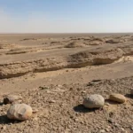
In some of the world’s driest deserts, wind doesn’t just move sand — it carves the ground itself into long, streamlined ridges. Those ridges are called yardangs. Once you know the look, you’ll start spotting them in photos and satellite views as clean, parallel “ribs” etched into the surface.
They matter because they’re not random scenery. Yardangs are one of the clearest natural “records” of persistent wind direction and long-term erosion in arid landscapes — on Earth, and even on Mars.
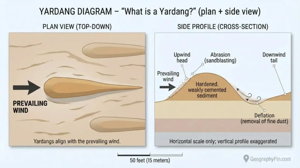
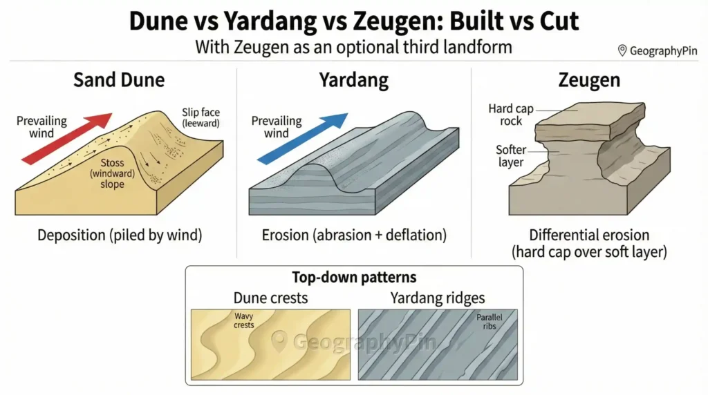
A yardang is a long, narrow ridge carved by persistent wind erosion (abrasion + deflation) in rock or hardened sediment. Many align with prevailing winds, often with a blunter upwind “head” and a tapered downwind “tail.” Heights can range from about 3–10 feet (1–3 meters) to up to ~100 feet (30 meters), while lengths in large fields can run over 1 mile (1.6+ kilometers).
How to use this article: For a fast ID, go to the 15-second check and yardang vs dune. For the science, jump to how yardangs form. For Mars, start at yardangs on Mars.
What is a yardang (and how to recognize one)?
A yardang is a wind-eroded ridge. The key detail is how it forms: it’s not built up like a sand dune. Instead, it’s carved down as wind removes weaker material and leaves streamlined ridges behind.
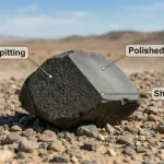
Most yardangs form in hardened sediments — compacted lakebed deposits, soft sedimentary rock, or layers of volcanic ash (tuff) that have cemented over time. These materials are firm enough to hold a ridge shape, but still weak enough for persistent sandblasting to sculpt them.
The classic yardang shape is directional. Many have a blunter “head” facing into the wind and a more tapered tail downwind. From above, the biggest clue is repetition: yardangs commonly appear in sets, not as one lonely ridge.
The 15-second yardang check (use this on photos or satellite maps)
Use this like a quick checklist. You’re trying to answer one simple question: does this look carved into the ground, or piled on top of it?
- Carved vs piled: Yardangs look like sculpted terrain; dunes look like loose crests of sand.
- Material: Yardangs are rock or hardened sediment; dunes are loose grains.
- Pattern: Yardang fields often show many near-parallel ridges with comb-like spacing.
- Direction: If you see blunt ends and tapered tails repeating in one direction, that’s a strong yardang hint.
- Stability: Yardangs change slowly by erosion; dunes can migrate or reshape after storms.
Yardang vs dune (and zeugen): the fast difference
Here’s the memory hook that never fails: dunes are built by wind, while yardangs are cut by wind. Dunes form when wind deposits sand into piles. Yardangs form when wind removes material from a firm surface.
You may also see another wind-eroded ridge type called zeugen. Zeugens are often blockier and commonly linked to a resistant cap layer protecting softer material underneath, so the softer rock erodes away first.
| Clue | Yardang | Sand dune | Zeugen |
|---|---|---|---|
| What it’s made of | Rock or hardened sediment | Loose sand grains | Layered rock (often with a harder cap over softer layers) |
| Process | Erosion (wind abrasion + deflation) | Deposition (wind piles sand) | Erosion (differential erosion under a resistant layer) |
| Movement | Mostly fixed; changes slowly by erosion | Can migrate; crests shift with winds | Fixed; changes slowly by erosion |
| Typical look from above | Long, parallel ribs / grooves carved into the surface | Crests and waves; patterns vary by dune type | More blocky remnants; sometimes “table-like” ridges |
| Scale (simple, honest framing) | Height: commonly 3–10 feet (1–3 m) to up to ~100 feet (30 m) in large landscapes. Length: individual ridges and ridge systems can extend over 1 mile (1.6+ km) in big fields. | From small ripples to very large dunes; height varies widely by desert and wind regime | Controlled by rock layering and exposure; scale varies by geology |
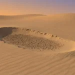
What is a yardang field?
A yardang field is an area where many yardangs occur together — sometimes hundreds or thousands. The surface takes on a repeating, parallel texture across a basin. In plain terms, the land develops a “grain,” because wind has been attacking it from a similar direction for a long time.
How yardangs form: wind as a cutting tool
Yardangs form where wind can act like sandpaper for a very long time. Two processes do most of the work: abrasion (sandblasting) and deflation (lifting and removing loose particles).
Abrasion happens when wind-blown grains strike and grind the surface. Deflation happens when wind carries away fine dust and sand, lowering the ground and keeping fresh material exposed. Together, they slowly turn a flat surface into alternating ridges and troughs.
However, not every windy place makes yardangs. The best “recipe” is a dry landscape with little plant cover, a steady supply of abrasive sand or gritty dust, and sediments or soft rock that have uneven hardness (so some parts resist erosion better than others).
Why yardangs line up with the prevailing wind
Yardangs tend to align with the dominant wind direction because erosion is strongest on surfaces facing into the wind. Over time, wind scours weaker zones into troughs and leaves slightly tougher zones standing as ridges.
Then the pattern reinforces itself. Airflow can accelerate through the gaps, which helps carve the troughs even more. That’s why a big yardang field can look almost engineered from above — the same forces are repeating the same work, over and over.
How long does it take to make a yardang?
There’s no single number, because erosion rate depends on rock type, sand supply, wind strength, and how often the surface stays exposed. Still, the honest scale is this: yardangs usually require long-term repeated erosion — often thousands to hundreds of thousands of years, and sometimes longer in very large landscapes.
In other words, it’s rarely “one dramatic storm.” It’s persistence: many windy days across long stretches of dry climate, carving the same surface again and again.
Where yardangs are found on Earth
Yardangs show up most clearly in arid basins where sediments are exposed, hardened, and repeatedly sandblasted by wind. Old lakebeds and dry basins are classic settings, because fine sediments can cement into soft rock — easy to sculpt, but strong enough to keep a ridge shape once it forms.
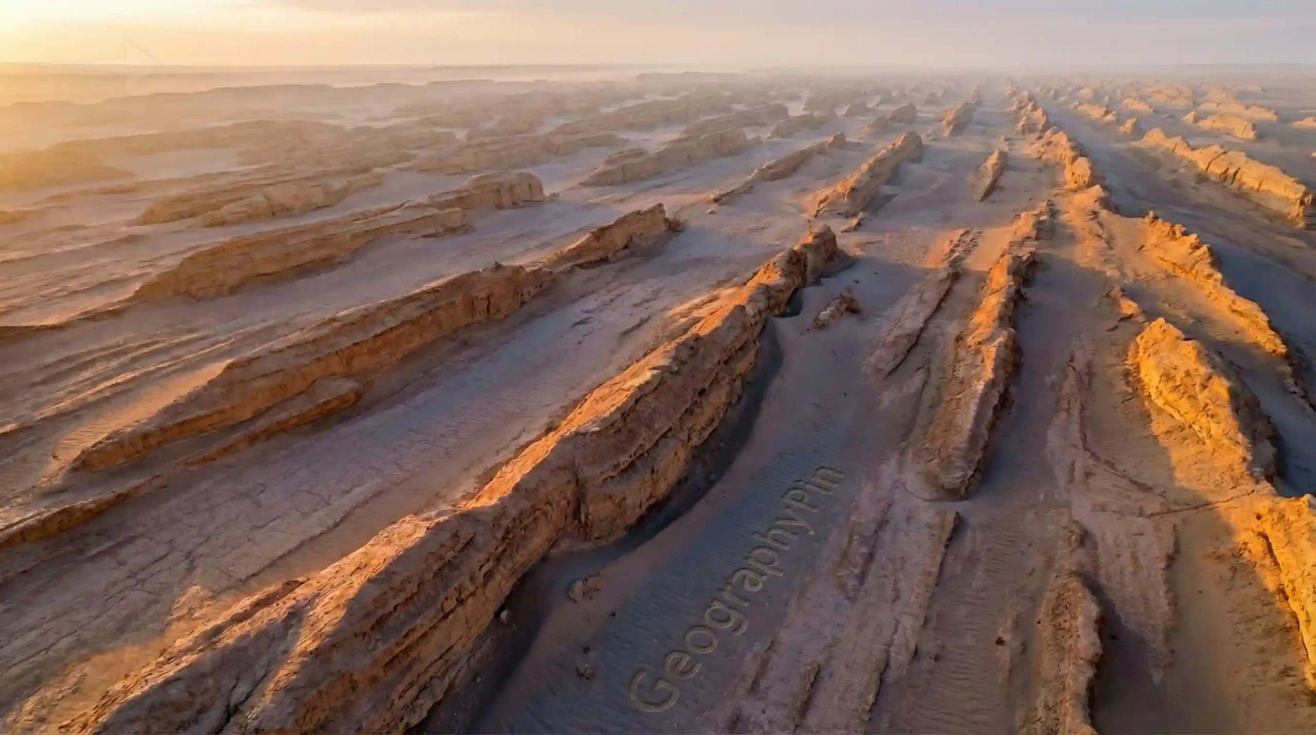
One of the most famous yardang-rich regions is Iran’s Lut Desert (Dasht-e Lut), especially the Kaluts area near Shahdad (Kerman Province), where wind-shaped ridges create striking, repeated patterns. Yardang landscapes also appear in parts of the Sahara and surrounding desert basins, across Central Asia, and in several arid regions where the same combination of sediments, dryness, and persistent winds exists.
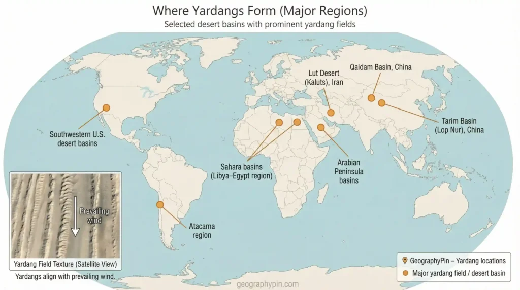
If you want to confirm a location, the most reliable method is simple: open satellite imagery and look for a wide patch of near-parallel ridges that appear carved into the ground (not piled sand). If a “yardang” photo online has no context, try finding the area on a map and see whether the ridge texture continues across a broader basin.
Famous yardang landscapes people talk about
Some yardang fields become famous simply because they’re massive, sharply sculpted, or easy to recognize in aerial imagery. The Lut Desert’s Kaluts are shared constantly because they look like endless stone waves.
Elsewhere, yardangs can be well-developed but less “branded” with a popular nickname — so they get overlooked until someone sees them from above. That’s why satellite imagery is such a cheat code for this landform.
Quick caution: online labels can be sloppy. Some photos tagged “yardang” are actually other wind-eroded ridges, or mixed landscapes with dunes nearby. When in doubt, return to the core test: carved (yardang) vs piled (dune).
Yardangs on Mars: the same shape, different planet
Yardang-like ridges exist on Mars too — and that’s a big deal. Mars has a thin atmosphere, but wind still moves sand and dust. Over long timescales, that motion can carve streamlined ridges in softer deposits, especially where layered materials are exposed.
The takeaway is practical: yardangs are directional. A Martian yardang field can act like a long-term indicator of prevailing winds, especially in broad deposits such as the Medusae Fossae Formation, where wind has sculpted repeated ridges across large areas.
What yardangs can reveal about past climate
On Earth, yardangs usually point to dry, exposed conditions with persistent winds and abrasive grains. On Mars, yardang-like ridges similarly support the idea of long-running, directional wind erosion. They also help scientists interpret how layered deposits were exposed, reshaped, and stripped back over time.
How to “read” a yardang in the field or on a map
You don’t need a geology degree to get useful information from yardangs. You just need a simple sequence and a calm scale check.
Start with alignment. In a field, multiple ridges pointing the same way are your best “wind direction” clue. On satellite imagery, the ridges often form clean, repeated lines that stand out even when the texture is subtle.
Then look for the “head and tail” idea. Many yardangs have a blunter upwind end and a tapered downwind tail. It’s a helpful clue — not a strict rule — so use it alongside the larger pattern.
Now check layers and carving cues. Yardangs often expose bedding or subtle layering in hardened sediments. If you see ridges with cut faces, rock-like texture, and troughs that look excavated rather than filled, you’re in yardang territory.
Finally, verify scale. If possible, measure ridge spacing and ridge length with map tools. This step prevents the most common mistake: thinking a small carved ridge is a “giant wall,” or assuming a massive yardang field is just a patch of dunes.
If you visit a yardang landscape in person, treat it like a remote desert first and a photo spot second. Heat, distance, and lack of shade are usually the real hazards. A common baseline many desert safety guides use is around 1 gallon (about 4 liters) of water per person per day for basic activity — and often more in strong heat. Plan routes, daylight, and navigation like you would for any remote terrain.
Common myths and mistakes about yardangs
Myth: “Yardangs are dunes.” They can look similar from a distance, but the process is opposite. Dunes are depositional (built up). Yardangs are erosional (carved down).
Myth: “They’re man-made ruins.” Yardang fields can resemble walls or corridors, but the repeating, parallel pattern across a broad landscape is a classic natural signature — especially when it continues for miles (kilometers) in one consistent direction.
Myth: “Bigger always means older.” Size depends heavily on rock hardness, sand supply, wind regime, and exposure time. Two landscapes can have very different yardang sizes even if they’re the same age.
Mistake: skipping the scale check. Photos without people or a scale bar can make ridges look tiny or enormous. If you can, use map distance tools and keep your units consistent.
FAQ
What’s the fastest way to tell a yardang from a dune?
Ask one question: Is it carved or piled? Yardangs are carved into rock or hardened sediment and often appear as repeated, grooved ridges across a broad area. Dunes are piles of loose sand and can migrate or reshape after winds. If you can find the location on satellite imagery, yardang fields often show long, near-parallel ridges that look “cut into” the surface.
Are yardangs dangerous to visit?
The ridges themselves usually aren’t the danger — the desert setting is. Yardang fields can be remote, hot, low on shade, and unreliable for phone coverage. Plan water, sun protection, navigation, and realistic distances, and avoid solo trips in unfamiliar terrain.
What are yardangs made of?
Many yardangs are carved from soft sedimentary rock or hardened sediments — such as siltstone, clay-rich layers, volcanic ash (tuff), or compacted lakebed deposits. The key is a surface that can erode under long-term wind abrasion and deflation, often with harder layers resisting erosion better than softer ones.
How big can a yardang get?
Sizes vary by geology and exposure. Small yardangs can be only 3–10 feet (1–3 meters) high. Larger ridges can reach up to ~100 feet (30 meters) in some big landscapes, and ridge systems in large fields can run over 1 mile (1.6+ kilometers) in length.
Do yardangs show wind direction?
Often, yes. Yardangs commonly align with prevailing wind direction over long periods. Many show a blunter upwind end and a more tapered downwind tail, and yardang fields typically run parallel like grooves, reflecting dominant erosive winds.
Are yardangs only found on Earth?
No. Yardang-like features are also observed on Mars. They matter because they suggest persistent wind erosion and can help scientists interpret long-term wind patterns and layered surface deposits.
What Did We Learn Today?
- A yardang is a wind-carved ridge made of rock or hardened sediment — not a loose sand pile.
- Yardangs form mainly through abrasion (sandblasting) and deflation acting over long periods.
- Dunes are built by wind; yardangs are cut by wind (the fastest way to remember it).
- Yardang fields often align like grooves, acting as a long-term record of prevailing wind direction.
- Similar ridge patterns exist on Mars, helping scientists interpret winds and layered deposits.
Wind seems invisible until it leaves marks that last. Yardangs are one of the clearest examples: a landscape shaped into direction and form by persistence. Once you know what to look for, you’ll start spotting them — out in the desert and on satellite maps — like signatures written across the ground.
Sources & Data Notes
This explainer was built from standard geomorphology references plus agency science pages. Scale figures are given as ranges (methods differ: single ridge vs ridge system, different mapping/measurement approaches). The diagrams and world map in this post are explanatory visuals, not an exhaustive global inventory.
- Definition (what a yardang is): Encyclopaedia Britannica — “Yardang”
- Key processes (wind erosion / deflation context): Encyclopaedia Britannica — “Deflation” (geomorphology)
- How streamlined yardangs evolve (shape + erosion mechanics): USGS — Evolution of the yardangs at Rogers Lake (California)
- Earth example used in this article (Lut Desert / Dasht-e Lut): UNESCO World Heritage — Lut Desert listing
- Mars section (Medusae Fossae yardangs): NASA Photojournal — Yardangs in Medusa Fossae and Medusae Fossae Yardangs
- Desert safety baseline (water planning): U.S. National Park Service — “One gallon (4 liters) per person per day” guidance