This profile covers the modern state of Iran (the Islamic Republic of Iran) in West Asia. “Persia” is a historical and cultural label that still appears in language and heritage contexts; it overlaps with Iran’s story, but the map here is the present-day country and the geographic forces that shape how it functions.
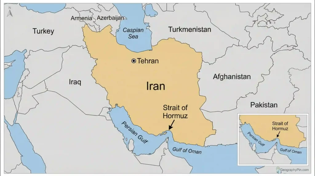
Iran is a large West Asian country where mountains, arid basins, and two coastlines (Caspian Sea in the north; Persian Gulf and Gulf of Oman in the south) determine where people concentrate, how trade routes run, and why security is managed through chokepoints. Its proximity to the Strait of Hormuz makes location a constant factor in global shipping and energy-risk decisions.
How to use this article: If you want a fast map-first summary, start with Quick facts and map orientation. For terrain and the physical “why,” go to Land & physical geography. If you care about cities, languages, and regional patterns, jump to People, languages, and the urban pattern. For economy and routes, read Economy and infrastructure geography. If your focus is borders, chokepoints, and why Iran’s location changes the risk math, go straight to Borders, security map, and why location matters. For quick answers, use the FAQ.
Quick facts and map orientation
Iran sits between the Persian Gulf region and the Eurasian interior. On a simple map, it touches the Gulf energy system to the south, the Caucasus corridor zone to the northwest, Central Asia’s steppe and desert edges to the northeast, and South Asia-facing borderlands to the east. That neighborhood density is the baseline reason Iran’s domestic story so often turns into a regional story.
Physically, the country is built around altitude and dryness. Mountain arcs frame a high interior plateau, which means “easy movement” tends to be channelled into corridors rather than spread evenly across the landscape. Those corridors become the practical skeleton for roads, rail, pipelines, migration, and trade—legal and informal. When pressure hits (economic restrictions, drought, regional conflict), stress shows up first along the same corridors because that’s where the country actually connects.
| Topic | What to know |
|---|---|
| Capital | Tehran |
| Approximate area | About 636,000 sq mi (about 1.65 million sq km) (CIA World Factbook, 2024) |
| Highest mountain | Mount Damavand, commonly cited at a little over 18,000 ft (over 5,500 m) (reference sources vary; Encyclopaedia Britannica, 2024) |
| Coastlines | Persian Gulf & Gulf of Oman (south); Caspian Sea (north) |
| Population (range) | Roughly in the 80–90 million range; estimates vary by year and method (UN DESA, 2024) |
Land & physical geography: mountains, basins, deserts, and coasts
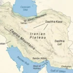
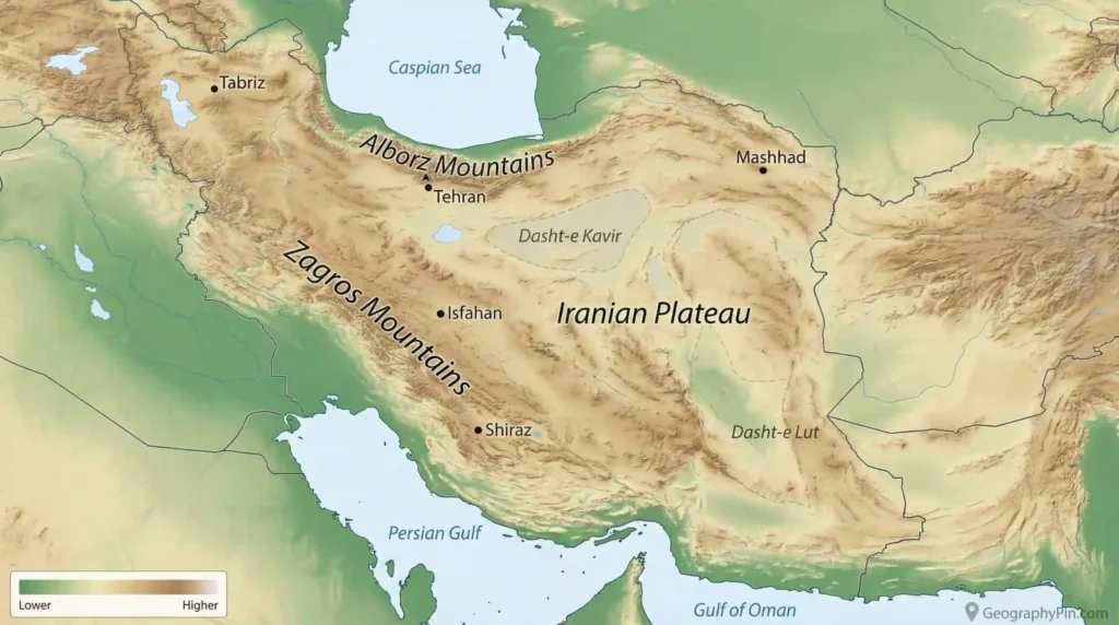
Iran’s most important physical fact is not a single desert name—it’s the shape of the land. The country is dominated by a high plateau framed by mountain systems, with arid basins and salt flats in the interior and narrow lowland windows along parts of the coasts. This produces a map where settlement, farming, and heavy infrastructure concentrate where water and grades allow it, not where the borders happen to be.
Two mountain arcs matter most for reading Iran quickly. The Zagros run along the west and southwest, forming a long barrier that also creates predictable corridors (valleys, passes) between interior cities and the Iraq-facing hinge. The Alborz rise near the Caspian, creating a sharp step from humid lowlands to the plateau behind them. Together, these ranges shape climate pockets, transport bottlenecks, and hazard exposure—especially earthquake risk in active tectonic zones (USGS, 2024).
Why the Zagros are a “corridor machine”
The Zagros don’t just slow movement; they channel it. When a mountain system stretches for long distances, roads and rail don’t have infinite options—they follow the few workable routes. That concentrates logistics, trade, and also enforcement. It also concentrates vulnerability: weather events, landslides, or localized conflict can disrupt more than one province because they hit the same shared route geometry.
Alborz + Tehran: capital geography under constraint
Tehran’s proximity to the Alborz is one of the reasons the capital functions as a compressed hub. The mountains limit northward expansion and funnel transport into a handful of routes, while the plateau side ties the city into the national spine running across the interior. This geography doesn’t “decide politics,” but it does decide daily mechanics: commute patterns, freight routing, and the cost of pushing infrastructure through steep terrain.
| Physical zone | Practical impact |
|---|---|
| Western/southwestern mountains (Zagros) | Channels overland movement into corridors; shapes borderland trade, enforcement, and route vulnerability. |
| Northern mountains (Alborz) + Caspian plain | Sharp climate contrast; limited passes; different agriculture patterns and connectivity to Caspian routes. |
| Interior plateau basins | Water becomes the growth limiter; cities and industry depend on sustainable supply choices. |
| Southern coast (Persian Gulf/Gulf of Oman) | Ports and energy export geography; heat and maritime risk can affect labor, insurance, and schedules. |
The simple takeaway: Iran’s geography is a constraint map before it is a postcard. It rewards corridor control, water management, and resilient logistics—because the landscape makes “workarounds” expensive.
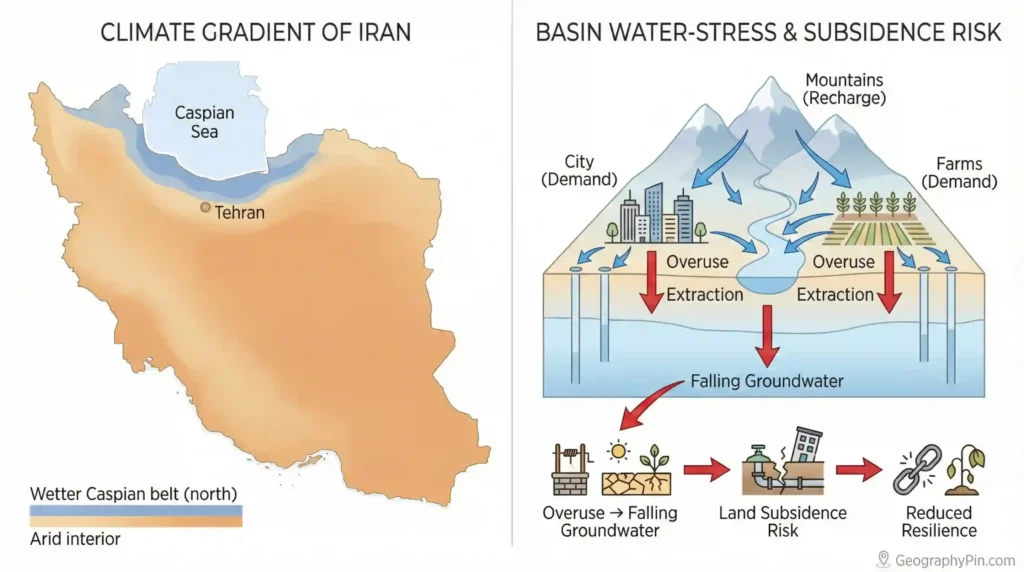
Climate, water, and environmental pressure
Iran’s climate is best understood as gradients created by elevation and distance from moisture. The Caspian-facing north can be relatively humid, while much of the interior runs semi-arid to arid. Mountain zones create cooler microclimates and seasonal snowpack that can matter downstream. These differences don’t just affect comfort—they set the baseline for agriculture, settlement density, and the cost of keeping cities functioning through heat and drought cycles.
Water stress is a long-running national issue because demand in many basins has outpaced renewable supply. Groundwater depletion in particular can become a slow crisis: wells deepen, pumping costs rise, and land subsidence risk grows in some areas (FAO, 2022). Water constraints are also political geography. Allocation decisions often play out between provinces and sectors—cities vs farms, industry vs wetlands—because the limiting factor is spatial: which basin, which aquifer, which canal, which upstream diversion.
Dust and downwind effects
Dust events show why environment can be regional security. Western provinces can be affected by dryland conditions across the wider Mesopotamian region, while interior basins can generate their own sources during drought years. When dust intensifies, it can disrupt schools, road safety, and labor productivity—meaning an “environmental” issue becomes a logistics and governance issue fast.
Wetlands and large lakes: restoration vs demand
Cases like Lake Urmia illustrate how difficult recovery can be once inflows decline and upstream water use expands (UNEP, 2023). Even when stabilization policies exist, long-term improvement often requires sustained basin-wide balance, which means trade-offs—less water-intensive farming, efficiency gains, or different regional development patterns. Geography sets the argument: water is finite inside closed or semi-closed basins, and the landscape enforces the math.
People, languages, and the urban pattern
Iran is multi-ethnic and multi-linguistic, with Persian (Farsi) as the national language but not the only daily language. Major communities speak Azerbaijani (Azeri) Turkish, Kurdish varieties, Arabic (especially in parts of the southwest), Baluchi, Turkmen, and other local languages, often concentrated in provinces near the relevant borders. This is normal borderland geography: people and language distribution rarely match political lines perfectly, and cultural ties can extend across frontiers.
Urban geography follows corridor logic. Big cities concentrate where water is manageable, where transport routes naturally converge, and where state and market institutions accumulate. Tehran’s dominance reflects capital-centralization dynamics, but it’s also a function of geography: a hub positioned to connect interior corridors while sitting close to mountain barriers that compress routes. Outside the capital region, large regional cities often function as “service capitals” for their wider zones—education, healthcare, industry, and trade.
Tehran’s pull and the shape of centralization
Capital regions tend to pull resources everywhere, but the intensity of that pull rises when a country’s corridor network funnels movement through a few main spines. Over time, this can concentrate universities, specialized medicine, corporate headquarters, and political institutions in and around Tehran. That concentration then becomes self-reinforcing: people move for opportunity, and opportunity moves where people already are.
Border provinces as contact zones
Iran’s border provinces face different “neighbor effects.” The west interacts with Iraq through trade and human ties; the northwest is shaped by the Caucasus corridor zone; the east faces different security and development pressures tied to Afghanistan and Pakistan. These differences don’t make any one province a stereotype. They simply mean that governance, infrastructure priorities, and economic opportunity can vary strongly by location.
| City | Node function |
|---|---|
| Tehran | Capital and national services hub; corridor connector under mountain constraints. |
| Mashhad | Northeast anchor; regional services and mobility node with cross-border relevance. |
| Isfahan | Interior node; historically and economically tied to plateau connectivity and industry patterns. |
| Tabriz | Northwest gateway; linked to the Caucasus direction and regional trade routes. |
| Ahvaz / Khuzestan region | Southwest lowland zone tied to energy and the Iraq-facing hinge. |
| Shiraz | Southern interior node connecting plateau routes with southern access corridors. |
If you want one phrase that explains Iran’s human geography: “rings and corridors.” Rings: mountain arcs and coastlines. Corridors: the practical routes where water, jobs, and transport align. That’s why regional shocks—economic restrictions, water shortages, security incidents—often cascade through specific chokepoints rather than spreading evenly across the map.
Government and administrative geography: where power concentrates
Iran is a centralized state in practice, with Tehran as the primary political-administrative node and a provincial structure that manages large territory and diverse regions. Even without debating ideology, the geographic pattern is clear: national decision-making, major ministries, top security institutions, and much of the regulatory apparatus are concentrated in the capital region, while provincial governance handles day-to-day administration across very different landscapes—from humid Caspian plains to arid interior basins and rugged border mountains.
Administrative geography matters because it shapes service access and development. A province with dense transport corridors and multiple large cities can absorb investment differently than a sparsely populated border province with long distances, harsh terrain, and fewer high-capacity routes. This is why infrastructure choices—where to upgrade a highway, where to strengthen rail, where to expand power generation—often double as governance choices: they shift which regions have reliable connectivity to the national core.
Location also influences how the state manages risk. Earthquake exposure pushes building standards and emergency planning in certain urban zones (USGS, 2024). Water stress pushes basin-level management conflicts and inter-provincial bargaining (FAO, 2022). Borderland security pushes surveillance and corridor control. In Iran, the geography isn’t a background layer; it’s a set of constraints that governance has to actively work with every year.
Economy and infrastructure geography: energy, industry, and routes
Iran’s economy is often summarized as “energy,” but its economic geography is better read as a network: where resources sit, where people concentrate, and how goods can reach markets under shifting external conditions. Energy production and petrochemicals are central, especially in southern and southwestern zones, while manufacturing and services cluster around major urban corridors. Agriculture remains important in regions where water and soils allow it, but water constraints make location and crop choices unusually decisive.
External restrictions—especially sanctions—tend to rewire trade geography rather than shutting connectivity off entirely. When access to certain markets or financial channels tightens, commerce often shifts toward regional partners, intermediaries, or overland routes that are less exposed to maritime risk or compliance pressure (IMF, 2023). This is why transport and logistics are not “supporting details” in Iran—they are the operational core of economic resilience.
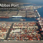
Ports, heat, and the southern gate
Iran’s southern coastline opens to the Persian Gulf and Gulf of Oman, tying it to global sea lanes and the Gulf energy system. Ports and coastal industry face harsh operating realities: extreme heat, humidity, and the fact that maritime risk perceptions can change schedules and insurance costs quickly. This is geography-driven economics: even a rumor of disruption can shift freight decisions because the alternative routes are longer or more expensive.
Overland corridors: the “second coastline”
Because the landscape channels movement into corridors, overland routes function like a second coastline—an alternative way to connect when sea access is risky or politically constrained. Westward routes can link into Iraq/Turkey-facing logistics; northern routes point toward the Caucasus and the Caspian direction; eastern routes run into the harder security-development geography near Afghanistan and Pakistan. Each route has its own constraints, but the key point is optionality: the map provides multiple connectivity strategies, even if none are frictionless.
| Node / zone | What it changes |
|---|---|
| Strait of Hormuz neighborhood | Maritime risk sensitivity; shipping and insurance decisions can shift quickly (IEA, 2023). |
| Southwest lowlands (energy-industrial belt) | Energy-linked production and export geography; vulnerable to heat stress and route disruptions. |
| Tehran–central corridor network | National distribution spine; bottlenecks matter because alternatives often mean steep terrain or long detours. |
| Caspian/Caucasus direction | Alternative trade orientation; depends on border policy, port capacity, and regional politics. |
| Eastern borderlands | Security-sensitive routes; development gaps can raise the cost of reliable connectivity. |
The most practical economic lesson is corridor realism: when a country’s routes are geographically constrained, reliability becomes a currency. Investments that reduce bottlenecks—better rail links, safer passes, more efficient ports, stable power supply—can matter as much as headline sector policy because they decide whether goods can move at predictable cost.
Borders, security map, and why location matters
Iran’s location places it beside multiple strategic systems at once: the Persian Gulf’s shipping-and-energy geography, the Iraq-facing west, the Caucasus corridor zone, the Central Asian direction, and the Afghanistan/Pakistan borderlands. That’s why “Iran news” often includes map-level effects like shipping risk changes, border policy shifts, or rerouted trade. The country is not a cul-de-sac; it is a hinge territory connecting several regions with different political climates.
Mountains amplify this. The Zagros and Alborz create defensible barriers in places, but they also compress movement into a limited set of corridors and passes. Security management tends to focus on those predictable chokepoints because that’s where flows concentrate: freight, people, and sometimes smuggling networks. In geographic terms, Iran’s security posture is partly a terrain posture.
The Strait of Hormuz: small distance, outsized leverage
The Strait of Hormuz is a narrow gateway between the Persian Gulf and the open ocean. Maritime navigation is concentrated into defined lanes, which makes disruptions—real or anticipated—especially sensitive for global shipping decisions (NOAA, 2020). Even when ships keep moving, the cost of moving them can change through insurance premiums, escort policies, and rerouting considerations. This is why a short stretch of water can become a global pricing factor.
Dual coastlines: two different strategic orientations
Iran’s southern coast connects to global maritime routes through the Gulf and Gulf of Oman, while the northern Caspian coast links into a different network oriented toward the Caucasus, Russia, and Central Asia. The Caspian is not an open-ocean substitute, but it offers different partnership and routing possibilities. In crisis scenarios, that duality matters: it can create partial redundancy in trade orientation, even if the volume and access conditions are not equal.
Border diversity: why each edge feels like a different country
Iran’s borders are not one story repeated seven times. The west is a population-and-trade interface facing Iraq and Turkey. The northwest points into the Caucasus corridor zone where regional tensions can alter transit options. The east faces a different security-development map tied to Afghanistan and Pakistan, with long distances and harsh terrain increasing the cost of governance and infrastructure. This diversity is the real meaning of “why location matters”: the state manages several distinct border problems at once, each with its own terrain and neighbor effects.
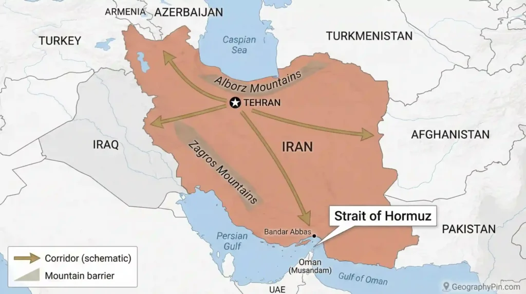
If you want a single sentence that captures Iran’s strategic geography in 2026: it is a corridor country sitting beside a chokepoint. That combination creates influence and vulnerability at the same time—because routes that matter to the world also attract pressure from the world.
FAQ
Is Iran the same as Persia?
Persia is a historical-cultural name often used in older sources and in discussions of Iranian civilization, art, and the Persian language. Iran is the modern country name used officially today. You’ll see “Persian” used for language and cultural references, while “Iran” is used for the state and its present borders.
Why is the Strait of Hormuz so important?
Because it is the narrow maritime gateway between the Persian Gulf and the open ocean. Shipping follows defined lanes, so even small changes in risk perception can affect insurance, routing decisions, and transport costs (NOAA, 2020). The impact comes from concentration: many Gulf routes depend on this single exit.
Is Iran mostly desert?
Large parts of the interior are arid, but Iran is best described as a high plateau framed by major mountain systems with deserts and basins in between. Where people live and where agriculture works depend heavily on water access and corridors shaped by terrain, not on a simple “desert vs not desert” label.
How does water stress affect Iran’s development?
Water availability can limit city growth, industrial expansion, and agricultural stability in interior basins. Groundwater depletion raises pumping costs and can increase land subsidence risk in some areas, turning water management into a strategic planning problem (FAO, 2022).
How do sanctions change Iran’s economic geography?
Sanctions often redirect trade rather than erase it. They can push commerce toward regional partners, intermediaries, and overland corridors while raising logistics and compliance costs (IMF, 2023). On the map, that increases the importance of reliable border crossings, corridors, and alternative routing options.
What’s the fastest way to understand Iran’s geography?
Start with four elements: the Zagros Mountains (west corridor control), the Alborz Mountains (Caspian-to-plateau contrast), the arid interior basins (water as a limiter), and the southern maritime gate near Hormuz (chokepoint politics). Those four explain most patterns readers notice in economy, cities, and security.
What Did We Learn Today?
- Iran is a plateau-and-mountain country where corridors matter more than straight-line distance.
- The Zagros and Alborz ranges both protect and constrain—barriers create predictable bottlenecks.
- Water stress is not a side issue; it shapes which regions can grow and how stable growth can be (FAO, 2022).
- The Strait of Hormuz is a classic chokepoint: defined lanes and concentrated traffic make risk perception powerful (NOAA, 2020).
- Iran’s “why location matters” is multi-directional: Gulf maritime logic in the south, Caspian/Eurasian options in the north, and diverse border realities east and west.
Iran’s geography doesn’t predict every outcome, but it does set the constraints: where people cluster, where trade can flow, and where pressure concentrates. Read the map first, and the headlines start making mechanical sense.
Sources & Data Notes
Country profiles can look “simple,” but the data underneath rarely comes from one perfect master source. For Iran, the cleanest way to stay honest is to treat facts in layers: stable geography (borders, coastlines, major ranges, overall area) is usually consistent across standard references like the CIA World Factbook and global mapping agencies; population and socio-economic indicators are best taken from UN DESA and World Bank series, with the understanding that the newest published year can lag behind real life by a year or two. For water stress and environmental pressure, broad signals come from FAO/UNEP reporting, while the local story often depends on basin-level studies and Iranian statistical releases that don’t always update on the same schedule. Earthquake and tectonic context is typically anchored in USGS/academic seismology references. Whenever this article uses a number, it should be read as “latest commonly published dataset,” not a live dashboard—so values may be rounded, and they can shift as agencies revise methods or release newer editions.