Algeria is a major North African country on the Mediterranean Sea. It is the largest country in Africa by area, but most of its people, farms, ports, and biggest cities are packed into the far north. That contrast between a populated Mediterranean belt and a huge Saharan interior is the key to understanding Algeria quickly.
Algeria also matters beyond geography. It is one of Africa’s main energy producers, an important state in the Maghreb, and a bridge between the Mediterranean world and the Sahara-Sahel zone.
Algeria is a North African country with a Mediterranean coastline, a population of about 46.8 million, and a territory dominated by the Sahara. Most people live in the north, while the south is sparsely populated but strategically important for energy production and desert transport routes.
How to use this article: Start with the fast check for the essentials, jump to land and climate for the physical setup, use the economic structure table for a quick scan, or go straight to the FAQ for short answers.
Where Algeria Is and Why It Matters
Algeria sits in the Maghreb of North Africa. It faces the Mediterranean Sea to the north and stretches deep into the Sahara to the south. It borders Tunisia and Libya to the east, Niger, Mali, and Mauritania to the south, and Morocco and Western Sahara to the west. In pure size, it is enormous: about 2.38 million square kilometers, which makes it the largest country in Africa and the tenth largest in the world.
That size matters because Algeria is not one uniform landscape. The northern belt contains most of the population, the main ports, and the most productive farmland. The south is mostly desert, but it holds major hydrocarbon zones and gives the country strategic depth across the Sahara.
Fast check
| Category | Profile |
|---|---|
| Official name | People’s Democratic Republic of Algeria |
| Capital | Algiers |
| Official languages | Arabic and Tamazight |
| Area | 2,381,741 square kilometers (919,595 square miles) |
| Population | About 46.8 million (2024) |
| Currency | Algerian dinar (DZD) |
| Highest point | Mount Tahat, 2,918 meters (9,573 feet) |
| UNESCO World Heritage properties | 7 |
Landforms, Climate, and Water
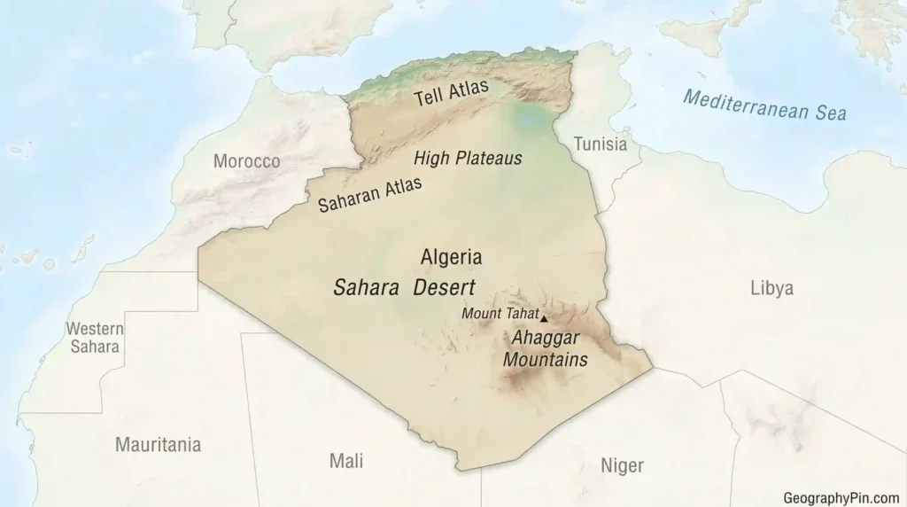
Algeria’s geography is easiest to understand from north to south. The country begins with a Mediterranean-facing coastal zone, then rises into the Tell Atlas. South of that come the High Plateaus and the Saharan Atlas. Farther south, the landscape opens into the Sahara, with sand seas, rocky desert, plateaus, oases, and the Ahaggar Mountains.
The Sahara is the dominant fact of Algerian geography. It covers more than four-fifths of the country, which is why most large cities and most farming are found in the north. Algeria’s highest point, Mount Tahat, stands in the Ahaggar range in the far south.
Land and climate in one view
Northern Algeria has a Mediterranean climate, with wetter winters and hotter, drier summers. Conditions become much drier as you move inland and southward. Water is a national constraint, not a side issue. Algeria faces severe water stress, and freshwater withdrawals are high relative to internal renewable resources. This helps explain why agriculture is concentrated in the north and why water management is a major planning challenge.
People, Cities, and Cultural Identity
Arabic and Tamazight are Algeria’s official languages, and Islam is the religion of the state. In daily life, the linguistic picture is broader: Arabic varieties, Tamazight varieties, and French all matter in different settings, especially in education, media, and administration.
Population is concentrated heavily in the north, especially along the coastal belt and nearby interior. Algiers is the capital and largest city. Oran is a major western port city, and Constantine remains one of the country’s main historical and urban centers in the east.
Culturally, Algeria brings together Arab, Amazigh, Mediterranean, Saharan, and anti-colonial historical layers. UNESCO lists 7 World Heritage properties in the country, including the Kasbah of Algiers, Roman-era sites such as Timgad and Djémila, the M’Zab Valley, and the mixed site of Tassili n’Ajjer, famous for both landscape and rock art.
That mix makes Algeria difficult to reduce to one label. It is African, Arab, Mediterranean, and Saharan at the same time, and that layered identity is one of the country’s most interesting features.
Economy, Energy, and Infrastructure
Algeria has one of the larger economies in Africa, with GDP of about $269.3 billion in 2024. Growth remained positive in 2024, and the country’s large domestic market, public spending, and energy sector all shape the overall picture.
The core economic fact is simple: hydrocarbons still dominate. Oil and gas remain central to exports, public revenue, and Algeria’s regional importance. Algeria is Africa’s largest natural gas producer and one of the continent’s main liquid fuels producers, which gives it influence in Mediterranean and European energy discussions.
Economic structure at a glance
| Sector or system | Why it matters |
|---|---|
| Hydrocarbons | Main export engine, major source of state revenue, and key reason Algeria matters in regional energy markets. |
| Agriculture | Important for domestic supply, but limited by climate and water stress. |
| Manufacturing and services | Important for diversification, jobs, and lowering exposure to oil-and-gas price swings. |
| Ports and transport links | Essential for connecting northern cities and southern resource zones to outside markets. |
Algeria is trying to diversify, and there has been some progress. Non-hydrocarbon exports have grown in recent years, but they are still small compared with the oil-and-gas sector. For readers looking for the big picture, the main point is that Algeria is still an energy-heavy economy, even as it works to broaden its base.
There is also a clear north-south economic divide. The north contains the densest settlement, main ports, and most industry. The south is much less populated but crucial for oil, gas, and long-distance desert logistics.
Government and Geopolitical Position
Algeria is formally the People’s Democratic Republic of Algeria. The constitution identifies Algiers as the capital, Arabic and Tamazight as official languages, and Islam as the religion of the state. Those points help explain how the state presents itself in legal and symbolic terms.
Geopolitically, Algeria matters because of both location and resources. It sits at the meeting point of the western Mediterranean, North Africa, and the Sahara-Sahel zone. Its size, borders, and energy role give it weight in Maghreb politics, regional security, and gas supply discussions.
Algeria is also an OPEC member, which reinforces its place in global energy diplomacy. In practical terms, the country’s influence comes from the combination of territory, energy, and geographic position rather than from any single factor alone.
FAQ
Is Algeria part of the Middle East or Africa?
Geographically, Algeria is in Africa, specifically North Africa. In political and cultural discussion, it is also often grouped into the wider MENA region.
Why is Algeria called the largest country in Africa?
Because its territory covers about 2.38 million square kilometers, which places it first in Africa by area.
What languages do people speak in Algeria?
Arabic and Tamazight are the official languages. French is also widely used in many parts of public and professional life.
Is Algeria mostly desert?
Yes. The Sahara covers more than four-fifths of the country, which is why most people and most major cities are in the north.
What drives Algeria’s economy?
Oil and gas remain the main drivers. They still dominate exports and play a major role in public revenue.
Why is Algeria strategically important?
Because it combines Mediterranean access, Saharan depth, regional political weight, and major energy production in one state.
What Did We Learn Today?
Algeria is best understood through its sharp north-south contrast. The north contains most people, ports, and farmland, while the Sahara dominates the map and shapes the country’s strategic depth.
Its identity is layered rather than simple. Algeria is African, Arab, Mediterranean, and Saharan at the same time.
Economically and geopolitically, Algeria matters because it combines large territory, major energy resources, and a strategic location in North Africa.
Sources & Data Notes
I wrote this profile with AI assistance and checked the core facts against current World Bank data, Algeria’s constitution, UNESCO World Heritage records, OPEC membership material, EIA energy analysis, and standard reference geography. I used the latest defensible figures for population, GDP, and growth, rounded where that improved readability, and kept the article focused on information a normal reader can scan quickly without losing the bigger picture.