Iran is easiest to understand as a high interior “roof” (the Iranian Plateau) with strong edges: mountains that act like walls, deserts that act like sinks, and coastlines that act like gateways. Once you see that shape, the map stops feeling like scattered place names and starts explaining itself—where cities cluster, where farming belts hold on, and why a few corridors carry serious strategic weight.
Quick disambiguation: here, “Iran” means the modern country on today’s political map. “Persia” is often used for historical/cultural context, and “Greater Iran” refers to a wider cultural sphere—related ideas, but not the same geography or borders.
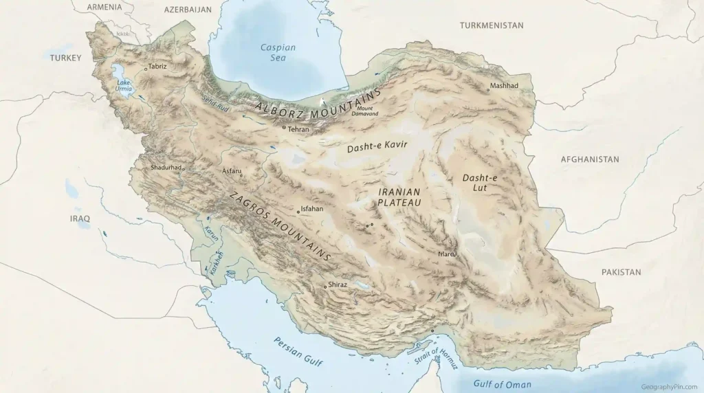
Iran is a plateau-centered country ringed by major mountain belts, with dry internal basins in the middle and two distinct water fronts: the Caspian Sea to the north and the Persian Gulf/Gulf of Oman to the south. That layout concentrates people, roads, and power into a few slopes, passes, and coastal gateways.
How to use this article: Start with the fast check to lock the map in your head, then use the interior vs north vs south comparison (with a table). If you care about strategy, go straight to borders & chokepoints. For a quick “mind map,” jump to the mental itinerary and finish with the FAQ.
The simplest map logic: a plateau with edges that behave differently
If you remember one idea, make it this: Iran is built around the Iranian Plateau, and the edges of that plateau are where the country’s geography becomes “loud.” The interior isn’t one flat tabletop—it’s uplands broken by broad basins—but the overall feel is high country with long distances, dry air in many regions, and big day–night temperature swings in exposed places. On a map, that interior is the part where rivers often fade, salt flats appear, and settlement depends on managed water rather than a single dominant river system.
Now look at the edges. The north is defined by the Alborz Mountains and the Caspian-facing strip: a steep barrier can turn a short drive into a climate flip. The west and southwest are defined by the Zagros: long ridges and valleys that decide where roads and communities can move efficiently. The south is defined by the Persian Gulf and the Gulf of Oman: maritime access, ports, and chokepoints. The east leans toward long-distance borderlands where geography turns into logistics—fewer dense “funnels,” more wide spaces that are costly to connect and control.
Fast check: how to recognize Iran’s regions at a glance
- High interior: uplands and basins—dry stretches, salt flats, and many waterways that don’t reach the sea.
- North barrier: the Alborz separates the plateau from the Caspian strip; the weather can change sharply across the range.
- Southwest wall: the Zagros runs in ridges and valleys; it channels routes through a limited set of passes.
- Two coastlines: Caspian north feels humid and green; the Gulf/Oman south is a maritime gateway with heat as a daily constraint.
- Desert cores: Dasht-e Kavir and Dasht-e Lut signal internal drainage, evaporation, and difficult infrastructure corridors.
Comparison that makes Iran click: interior vs north vs south
A practical way to read Iran is to compare three “modes” you can actually feel on the ground: the plateau interior, the Caspian-facing north, and the Gulf/Oman-facing south. This isn’t about drawing perfect lines; it’s about noticing signals—terrain, air, water availability, and what people build there. Use it to anchor everything you’ll read in the later sections.
| Zone | Terrain & water signals | What it tends to shape |
|---|---|---|
| Interior plateau & basins | Uplands broken by broad basins; salt flats and dry washes; many streams end inland | Cities cluster where water is managed; long road legs; strong season and day–night contrasts |
| Caspian-facing north | Low, humid strip backed by steep mountains; greenery is the giveaway | Dense farming belts; mountain passes become “gates” linking coast to plateau |
| Zagros slopes & valleys | Long folded ridges and valleys; movement funnels into corridors and passes | Roads and pipelines align with terrain; quake and landslide risk matters for infrastructure |
| Persian Gulf & Gulf of Oman shores | Hot coastal plains and port zones; sea access is the key advantage | Ports, shipping lanes, and chokepoints dominate map logic; water supply and heat shape daily life |
Mountains that fence the plateau: Zagros and Alborz
Iran’s mountains are the country’s working geometry. They don’t just rise above the map—they decide where movement is easy, where it is expensive, and where a “short distance” becomes a major project. The Zagros runs along the west and southwest as a long belt of ridges and valleys. The Alborz runs along the north as a sharper barrier above the Caspian. Together, they help explain why Iran has clear corridors and gates rather than evenly open terrain.
The Zagros: ridges that channel roads, rivers, and settlement
The Zagros is often experienced as repetition: ridge, valley, ridge, valley. That repetition matters because it channels transport into the same practical routes again and again. It also shapes how regions connect—west-to-east lines can be harder than they look, while valley-aligned routes can feel like natural highways. Provinces near the Zagros front can be close to major neighbors on paper, yet still separated by terrain in a way that affects trade, security, and infrastructure planning year after year.
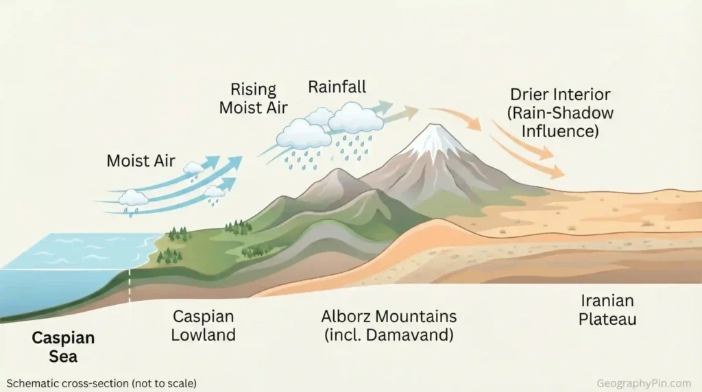
The Alborz: a steep climate divider above the Caspian
The Alborz is the “climate flip” range. It helps trap humid conditions on the Caspian-facing side while the plateau immediately south can stay much drier. That’s why Iran can hold two very different environments close together: a green coastal strip and a plateau interior that often depends on careful water management. It also makes north–south passes and tunnels unusually important. When a range is steep, the crossing points are not just roads; they become national connectors.
Mount Damavand as an anchor point
Mount Damavand is a widely recognized symbol of the Alborz: a dominant volcanic peak that anchors the idea of “high north.” Its height is commonly given as about 18,400 feet (5,610 meters) (Encyclopaedia Britannica, accessed 2026). You don’t need to memorize the number; the geographic meaning is what matters—snow storage, steep gradients, and a landscape where elevation can outweigh latitude in shaping local climate.
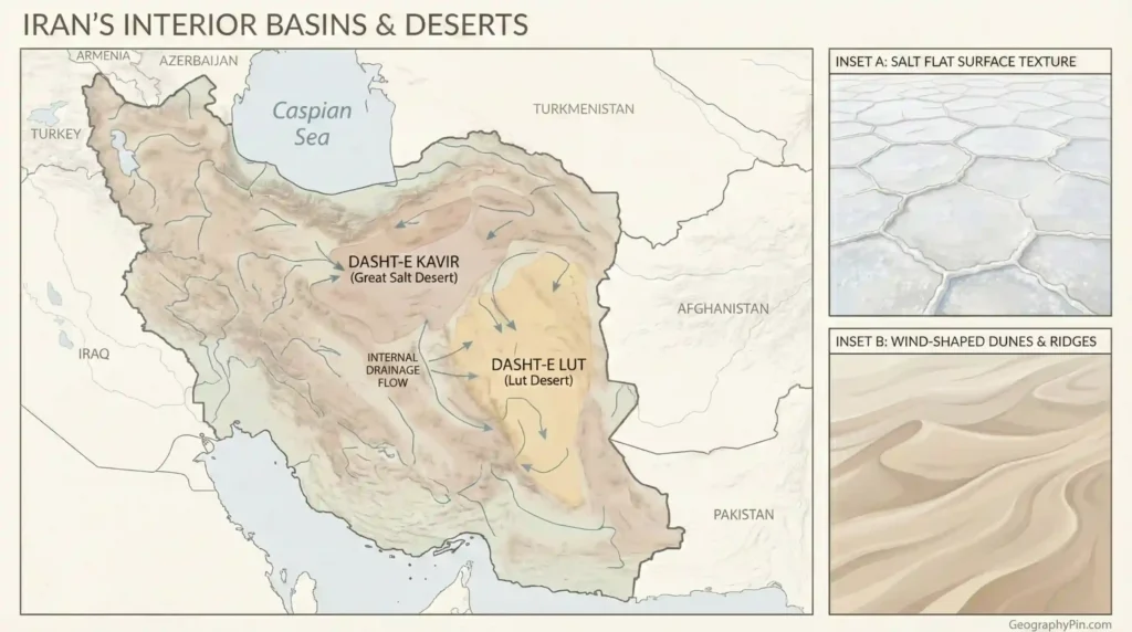
Basins and deserts: why the interior can drain inward instead of outward
People often summarize the interior as “desert,” but Iran’s interior dryness has structure. Much of the plateau is organized into basins where water can end its journey inside the country rather than reaching an open ocean. That internal drainage is why salt flats form, why seasonal waterways can fade into dry ground, and why water management becomes a core geographic storyline instead of a side note. On a map, these basins function like sinks: they collect, evaporate, and leave minerals behind.
Dasht-e Kavir: salt, seasonal flows, and “where rivers disappear”
The Dasht-e Kavir is often used as shorthand for Iran’s salt-desert core. The key lesson isn’t just “it’s dry,” but “water doesn’t behave the way people expect.” Instead of feeding a permanent downstream system, many flows are seasonal and end internally. That changes settlement logic: cities and farming belts do best where water can be stored, diverted, or accessed reliably—often nearer foothills, springs, or long-managed systems—rather than in the most open flats.
Dasht-e Lut: extreme aridity and wind-shaped corridors
The Dasht-e Lut is another major interior desert zone, known for harsh aridity and broad, exposed surfaces where wind becomes a serious sculptor. This matters beyond scenery: in open basin environments, dust and sand can disrupt transport, reduce visibility, and increase maintenance costs for roads, rails, and power corridors. When you see long straight infrastructure lines across the interior on a map, remember they cross environments that can be mechanically punishing over time.
Coasts and water fronts: Caspian north, Gulf south, and why they function differently
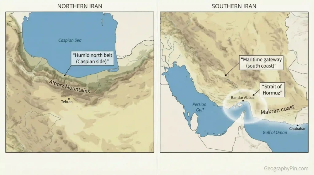
Iran touches major water in two very different ways, and each one creates a different “edge” of the country. The Caspian side is a north-edge story: a low strip pressed between sea and mountains where humidity and vegetation can feel surprising if your mental picture is only plateau and desert. The southern coast is a gateway story: the Persian Gulf and the Gulf of Oman connect Iran to shipping routes, port infrastructure, and wider maritime corridors. Same country, completely different map logic.
Caspian Sea: the humid belt backed by a hard barrier
The Caspian-facing strip benefits from moisture patterns and lowland terrain, while the Alborz behind it acts like a wall. That combination helps explain why coastal farming belts and towns can concentrate on the north side, and why crossings through the Alborz become important connectors to the plateau. The Caspian is also an enclosed sea, meaning maritime dynamics here are regional rather than truly global in reach.
Persian Gulf and Gulf of Oman: ports, heat, and maritime access
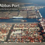
Along the Persian Gulf and the Gulf of Oman, sea access changes the country’s options: ports can connect to global routes even when the interior is difficult. Bandar Abbas is a key example of a port city tied closely to the Strait of Hormuz’s geography, while Chabahar on the Gulf of Oman is often discussed as an open-ocean-facing gateway that sits outside the tightest Persian Gulf bottleneck. The constant geographic tradeoff down south is between access (sea lanes, ports) and constraints (heat, water supply, narrow coastal plains in places).
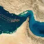
Near the southeastern edge of the Persian Gulf system, the Strait of Hormuz becomes the classic bridge between geography and geopolitics. At its narrowest, it is often described as about 21 miles (roughly 33–34 kilometers) wide, with shipping lanes much narrower within it (Reuters, 2025). The exact number isn’t the main point. The main point is that a lot of global movement gets squeezed through a small piece of water—and Iran’s coastline sits right beside that squeeze.
Where people live: cities, farms, and the “water-and-slope” rule
Iran’s settlement pattern gets clearer when you stop asking “Where is the flattest land?” and start asking “Where does water stay reliable enough to build a city?” In plateau environments, the open interior is not automatically the best place to concentrate people unless water can be stored, delivered, and protected. That’s why foothills, valleys, and engineered water systems matter so much. Geography doesn’t eliminate choice, but it does set the price of each choice—especially when water is scarce or seasonal.
Tehran and the northern foothills logic
Tehran’s position on the southern side of the Alborz fits the “water-and-slope” rule: close enough to mountain-fed systems and passes to matter, while still tied into the plateau network that reaches deep into the country. This foothill positioning also reflects a broader pattern across Iran: many major population centers grow where terrain offers a workable balance—access to upland water sources, routes that can cross mountains at known gates, and enough buildable land to expand.
Khuzestan and the Zagros front as a lowland gateway
In the southwest, the geography shifts again. Khuzestan sits near the Zagros front where lowlands meet mountain systems and cross-border corridors, especially toward Iraq. You don’t need precise population or production numbers to understand why this matters: when a lowland plain meets a mountain wall, the transition zone often becomes a transport and infrastructure spine. It’s one of the places where Iran’s physical geography and its neighborhood geography meet directly on the ground.
Culture and local economies also reflect the map. Mountain valleys can preserve distinct communities over long periods, border plains can pull trade and movement across lines, and port provinces can face outward through maritime routes. Geography doesn’t “explain everything,” but it explains what tends to be easy, what tends to be expensive, and what requires constant systems to keep working—especially water, transport, and energy infrastructure.
Borders and chokepoints: why location is geopolitical
Iran’s geography becomes geopolitical when you look at its neighborhood and its gateways. Iran is not a “one-frontier” country; it sits as a multi-direction border state. Terrain changes what borders mean in practice: mountains tend to reduce the number of easy crossings and concentrate routes into known passes, while wide borderlands can make control and infrastructure more costly. Even without quoting border-length numbers, the map makes the point: Iran’s borders connect it to Turkey, Iraq, Armenia, Azerbaijan (including Nakhchivan), Turkmenistan, Afghanistan, and Pakistan—each with its own corridor logic and friction points.
| Direction | Neighbor(s) | Terrain logic you’ll see on the map |
|---|---|---|
| West / Southwest | Turkey, Iraq | Mountain and foothill corridors; crossings cluster where terrain allows |
| North / Northwest | Armenia, Azerbaijan (incl. Nakhchivan), Turkmenistan | Mixed mountains and lowlands; regional connectors and enclosed-sea dynamics near the Caspian |
| East / Southeast | Afghanistan, Pakistan | Long-distance borderlands; fewer dense funnels, higher logistics costs across open spaces |
The sea borders add a second layer. The Caspian is enclosed—more regional in who matters and how maritime space works. The Persian Gulf and Gulf of Oman are the opposite: plugged into global shipping and energy routes. That’s why chokepoints like the Strait of Hormuz keep returning in real-world discussions. Geography doesn’t create every crisis, but it sets the stage: narrow passages, limited alternatives, and coastal infrastructure that cannot simply relocate inland when pressure rises.
A simple mental itinerary to picture Iran (no map needed)
To picture Iran in your head, imagine a loop with seven stops. Start on the plateau interior: big sky, dry basins, and cities that feel like islands connected by long roads. Then move to the Zagros edge, where ridges and valleys repeatedly turn straight-line distance into “terrain distance.” Next, climb toward the Alborz, a sharp barrier that makes the north–south transition feel physical, not abstract.
Drop into the Caspian strip, where humidity and greenery signal a different water story. Now swing back across the interior and head south to the Persian Gulf coast, where ports and maritime routes reshape what “connection” means—Bandar Abbas sits close to the Hormuz squeeze point, while coastal routes reflect heat and water constraints. Continue east to the Gulf of Oman, where Chabahar is often discussed as an open-ocean-facing gateway. Finally, return through the desert basins, where internal drainage and wind remind you why water management is a continuous national task, not a one-time fix.
One scale detail that helps anchor the “small place, big impact” idea: the Strait of Hormuz is often described as about 21 miles (roughly 33–34 kilometers) wide at its narrowest point (Reuters, 2025). Even if the exact figure shifts by definition, the map reality stays: global movement gets pinched into a tight maritime corridor beside Iran’s southern shore.
Common myths and mistakes
Most confusion about Iran’s geography comes from flattening the country into a single stereotype—either “all desert” or “all mountains.” The better approach is structural: plateau interior plus strong edges. Once you adopt that lens, you’ll stop expecting one climate, one settlement pattern, or one “main route.” You’ll also avoid mixing terms that sound similar but mean different things on the map (Iran, Persia, Greater Iran). Use the points below as a quick self-check when you read headlines, plan routes, or compare provinces.
- Myth: “Iran is mostly one flat desert.” Mistake: ignoring the plateau-and-mountain structure that shapes climate, roads, and settlement.
- Myth: “Coastline automatically means easy living.” Mistake: forgetting heat and water supply constraints, plus narrow coastal plains in places.
- Myth: “Borders are just lines.” Mistake: treating mountain passes and open borderlands as equal—terrain decides which crossings become practical corridors.
- Myth: “The Caspian is basically like the open ocean.” Mistake: missing the difference between an enclosed sea (regional dynamics) and ocean-connected routes (global dynamics).
- Myth: “Persia = Iran = Greater Iran.” Mistake: collapsing a modern state, a historical label, and a cultural sphere into one map concept.
FAQ
Is Iran part of the Middle East or Central Asia geographically?
Iran sits at a crossroads. It is commonly grouped with Southwest Asia (often called the Middle East), while its plateau and eastern borderlands connect into broader Central/South Asian geographies. The practical takeaway is “bridge zone”: plateau interior, mountain borders, and two major maritime faces.
What are the two biggest mountain systems in Iran?
The Zagros in the west/southwest and the Alborz in the north are the headline belts. Together they shape rainfall patterns, earthquake exposure, and where roads and cities concentrate into workable corridors.
Why do the Dasht-e Kavir and Dasht-e Lut matter beyond “it’s dry”?
They represent interior basins where evaporation and internal drainage shape settlement and infrastructure. Water often ends inland, which raises the importance of storage, allocation, and engineered delivery rather than relying on a single large river spine.
Why is the Caspian region so different from much of the plateau?
The Alborz barrier helps separate a humid coastal environment on the Caspian side from a generally drier plateau interior just south of the range. On the ground, that can mean a noticeable change in vegetation and air moisture across a relatively short crossing.
How does geography shape Iran’s geopolitics?
Iran’s position as a multi-border state, plus its southern coastline beside a major maritime chokepoint, means a few passes, ports, and sea lanes can matter disproportionately. Mountains and deserts reduce the number of easy overland routes; narrow waters amplify the strategic value of specific coastal stretches.
Is Mount Damavand the highest point in Iran?
It is commonly cited as Iran’s highest peak, and its height is often given around 18,400 feet (5,610 meters) (Encyclopaedia Britannica, accessed 2026). Exact measurements can vary by method, but the geographic meaning stays the same: a dominant summit anchoring the Alborz landscape.
What Did We Learn Today?
- Iran is best understood as a plateau-centered country where the “edges” (mountains and coasts) concentrate routes and settlement.
- The Zagros and Alborz don’t just shape scenery—they shape corridors, passes, and local climate contrasts.
- The interior deserts and basins reflect internal drainage and evaporation, making water management a core geography theme.
- Iran’s two water fronts function differently: a humid Caspian edge versus a Gulf/Oman maritime gateway.
- Geopolitics often follows geometry: chokepoints and limited crossings can matter more than their physical size suggests.
Iran’s geography isn’t “complicated” because it’s obscure—it’s complicated because it’s built from strong contrasts packed close together. Once the plateau-and-edges pattern becomes your default, the map starts reading like a system instead of a list.
Sources & Data Notes
This explainer leans on stable reference geography: standard regional labels (Iranian Plateau, Zagros, Alborz, Dasht-e Kavir, Dasht-e Lut), atlas-style physical descriptions, and widely used topographic baselines (e.g., SRTM-style relief) for map logic. Where a concrete measurement appears (Damavand’s commonly cited height; the Strait of Hormuz’s commonly cited narrow width), it is attributed in-text (Encyclopaedia Britannica, accessed 2026; Reuters, 2025) and phrased cautiously because definitions and measurement methods can vary. Values may be rounded, and details can be updated as newer datasets and map standards appear.