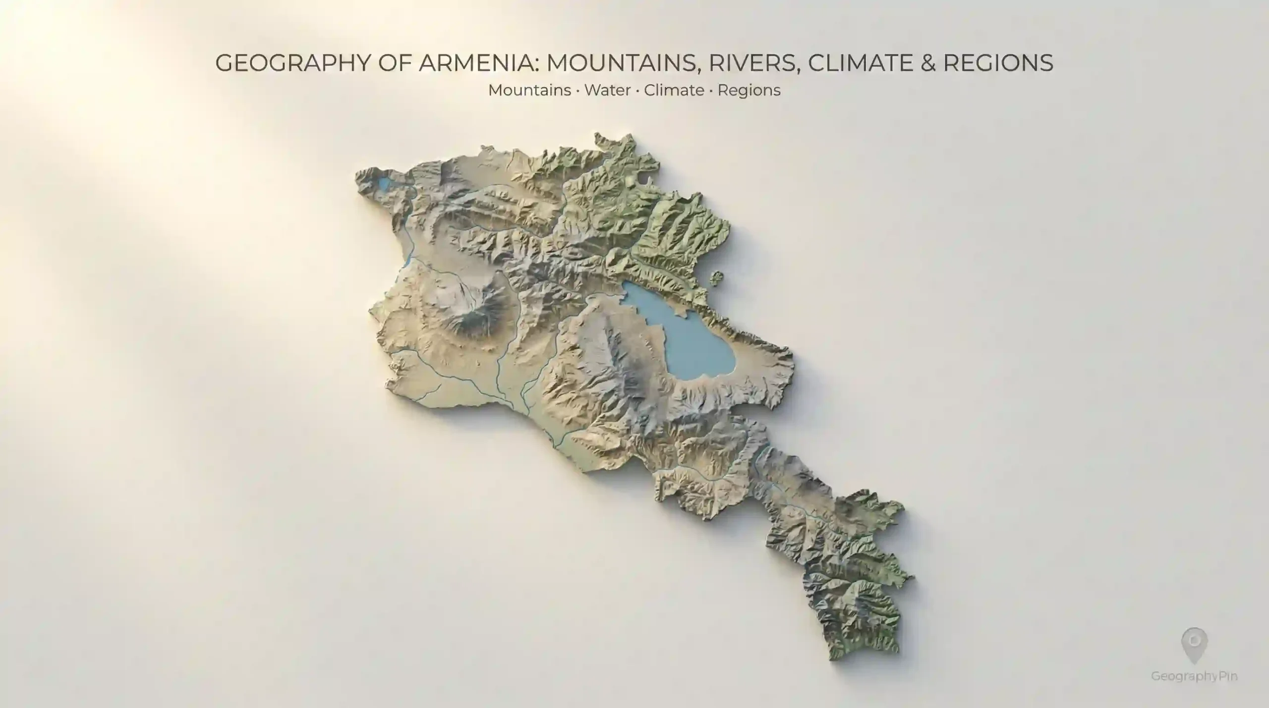
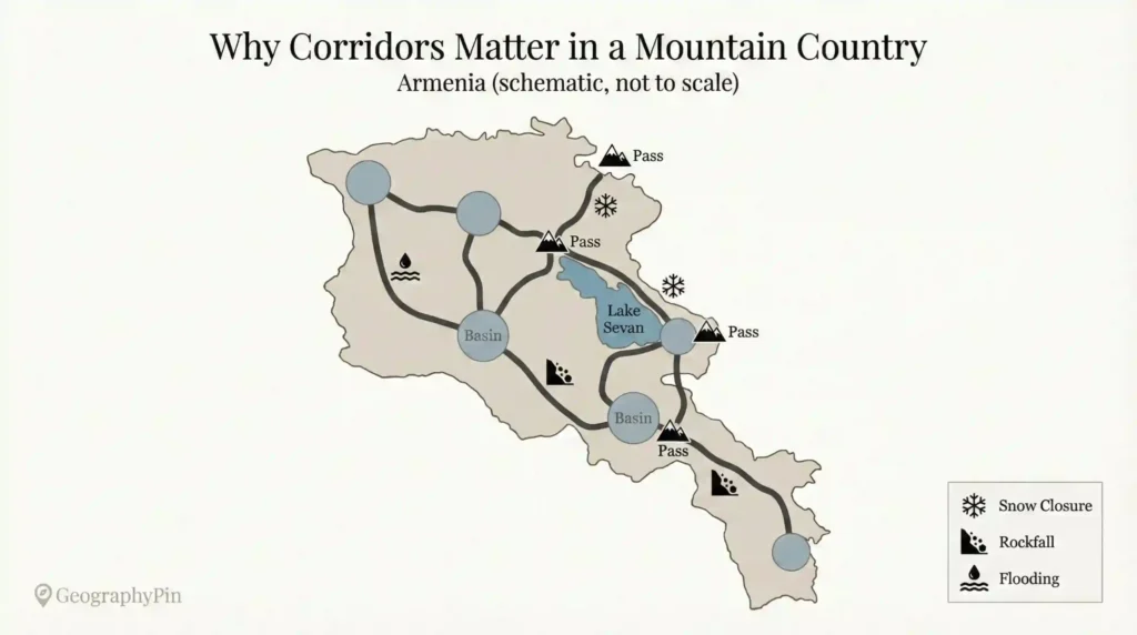
Armenia (the modern Republic of Armenia in the South Caucasus) is compact on a world map—about 11,484 square miles (29,743 square kilometers)—but it behaves like a much larger landscape because most of it is highland. A ridge can block wind, a basin can trap warmth, and a pass can decide whether a route is routine or delayed.
One quick clarification: people sometimes say “Armenia” meaning the wider Armenian Highlands as a historical-geographic region that stretches beyond today’s borders. That broader term matters in history and culture, but here I’m talking about the modern state’s physical geography—what you see on an Armenia map and feel on the ground.
Armenia’s geography is a highland system of ridges, basins, and tight corridors. Mountains and uplifted plateaus shape where people settle, how water is stored and routed, and why local weather can change quickly across short distances. Lake Sevan and river valleys anchor farming, energy, and the country’s most practical routes.
How to use this article: Skim the one-glance map, then jump to what you need: mountains, water, climate, regions, or corridors. Use FAQ for quick checks.
Armenia’s geography in one glance
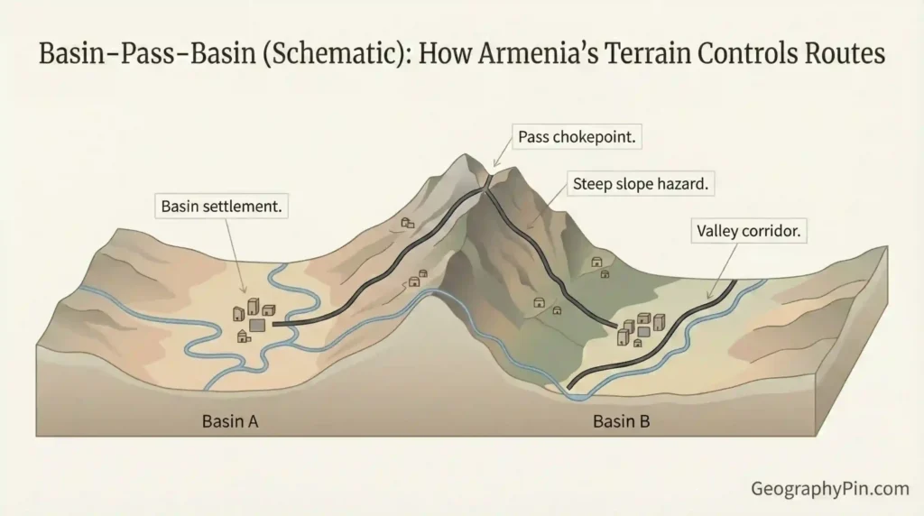
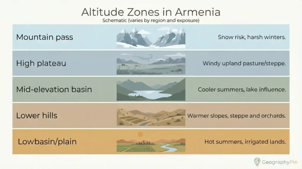
Armenia is easiest to understand as a set of elevated “rooms” connected by passes. Mountain ridges form the walls, and basins and plateaus form the floors. It’s landlocked, so there’s no coastline to smooth temperatures or offer easy transport alternatives. Instead, rivers, reservoirs, and seasonal snowpack carry the practical weight—supporting irrigation, hydropower, and the valley routes that connect towns.
That “room-and-pass” layout explains why travel can feel vertical. Roads behave like water: they follow the lowest channel until they have to cross a ridge, then they commit to a pass and drop into the next basin. It also explains why local conditions can change fast. Two places that look close on a map can feel different because one sits higher, one is more exposed to wind, or one is tucked into a basin that traps air and temperature.
Fast anchors for reading Armenia on a map
These are not “random facts.” They’re anchors that make the rest of the story click—especially if you’re looking at a relief map, a road map, or a climate map.
| Anchor | What it means |
|---|---|
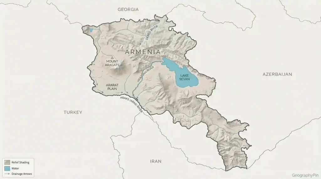
| Highest peak (within Armenia) | Mount Aragats rises to about 13,418 feet (4,090 meters) (Britannica, 1998). |
| Signature lake | Lake Sevan sits around 6,250 feet (1,905 meters) above sea level (Britannica, 1998). |
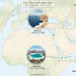
| Lake scale (why it matters) | Lake Sevan covers roughly 525 square miles (1,360 square kilometers) (Britannica, 1998), big enough to influence local winds and shoreline settlement. |
| Landlocked reality | With no coastline, transport and trade lean heavily on a limited set of internal corridors and border routes. |
| Provinces | Marz (plural: marzer) are provinces; many provincial differences track terrain and exposure. |
Comparison: the repeating landscape zones (and their tradeoffs)
Instead of memorizing place names first, learn the repeating zones: forested uplands, open high plateaus, interior plains and basins, lake-influenced belts, and steep ridge-and-valley corridors (especially in the south). These zones explain why one area leans into pasture and hardy crops while another leans into orchards, irrigated fields, or corridor-based trade. The table below is a practical guide: what the land feels like, what it tends to support, and what it tends to complicate.
| Zone (plain-language) | What you’ll notice | Common tradeoffs |
|---|---|---|
| Forested northern uplands (e.g., parts of Tavush and Lori) | Greener slopes, shaded valleys, fog pockets, tighter river corridors | Better moisture in places, but narrow roads and landslide risk after heavy rain |
| High plateaus and open uplands (e.g., parts of Shirak and Gegharkunik) | Wide horizons, stronger winds, longer winters, big day–night swings | Good for pasture and hardy crops, but exposure and snow closures can disrupt routes |
| Interior plains and basins (e.g., Ararat Plain areas) | Flatter ground, intensive farming, irrigation channels, hotter summer feel | High productivity potential, but water allocation and heat stress become key constraints |
| Lake-influenced belt (Lake Sevan shores and nearby heights) | Cooler air near water, sudden gusts, fast weather shifts | Tourism and fisheries matter, but shoreline pressure and water-balance debates stay persistent |
| Southern ridge-and-valley corridors (e.g., Syunik and Vayots Dzor) | Steep ridges, tight valleys, dramatic passes, exposed rock | Strategic routes and resources, but closures and chokepoints carry outsized impact |
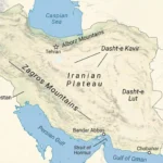
Mountains and highlands: how Armenia’s relief is built
Armenia sits in the rougher side of the South Caucasus terrain, where uplift and faulting (over long time spans) helped build strong relief—ridges, broken plateaus, and basins. Volcanic landforms also appear in parts of the country, leaving hardened layers and distinctive rock textures. The result is a repeating pattern: basins that collect settlement and farming, and ridge lines that force movement into a smaller number of passes.
Mount Aragats is the clean “reference point” for Armenia’s vertical character, rising to about 13,418 feet (4,090 meters) (Britannica, 1998). But the bigger story is not one summit—it’s how the whole country behaves like highland. Relief controls where forests hold on, where pasture opens up, where orchards prefer sheltered slopes, and where a valley becomes the only realistic corridor for a major road.
Mountains also shape hazards and maintenance costs. In steep landscapes, intense rain can trigger rapid runoff; freeze–thaw cycles can crack surfaces and weaken cut slopes; and earthquake risk is part of the broader regional reality, meaning landslides and infrastructure damage are always in the planning conversation even when the weather is quiet. This is why Armenia’s geography is not “scenery first.” It’s a constraint system that organizes routes, budgets, and development decisions.
Terrain textures you’ll actually notice
Armenia’s highland is not one uniform “rock world.” Some areas show dark, sharp-edged volcanic stone; other areas are softer and erode into rounder slopes. That difference matters because it changes where springs emerge, how stable a road cut is after heavy rain, and how quickly water runs off into a narrow valley. Once you start noticing texture, you start predicting behavior: which slopes fail, which valleys flood fast, and which routes become fragile in certain seasons.
Rivers, Lake Sevan, and the water logic of a highland
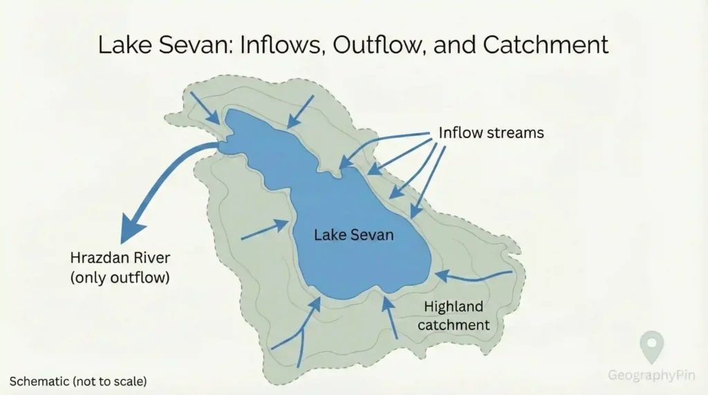
In a landlocked mountain country, water is less about long, navigable rivers and more about timing and control: snowpack, spring melt, summer irrigation demand, and how quickly a narrow valley turns a storm into fast runoff. Armenia’s rivers often drop quickly from uplands to basins, which is exactly why they matter. Short rivers can still be decisive for irrigation, hydropower, and corridor-building because valleys are the natural routes through relief.
Lake Sevan is the center of gravity in this story. It lies at roughly 6,250 feet (1,905 meters) above sea level (Britannica, 1998), and its surface covers about 525 square miles (1,360 square kilometers) (Britannica, 1998). Those numbers translate into real effects: shoreline breezes, local humidity shifts, and a major water “buffer” that turns lake level and outflow management into national-scale questions. In highland systems, storage and release timing can matter as much as total volume (national hydromet and water-management reporting, latest available editions vary).
Why river valleys matter even when rivers aren’t “big”
A single valley can carry a road, a chain of towns, irrigation channels, and energy infrastructure because it’s the easiest passage through steep land. That’s why names like the Araks (Aras) system, the Hrazdan, and the Debed show up repeatedly in corridor talk: they represent routes as much as waterways. Rivers also expose geology—terraces, cliffs, and cut layers that tell you where the land has been carved down over time. If you want to read Armenia’s landscape quickly, follow the valleys and look at what the water had to cut through.
Climate and seasons: altitude beats latitude
Armenia’s climate makes the most sense as continental with strong altitude zoning. Lower basins and plains can feel hot in summer, while nearby uplands stay noticeably cooler; winters, meanwhile, tighten their grip at higher elevations, where snow and ice linger and freeze–thaw cycles become a defining force for roads and buildings. Because the country is far from ocean moderation, seasonal swings can feel sharp even when the day starts bright.
Precipitation is uneven as well. Northern and higher areas tend to hold more moisture and support more forest cover, while interior plains can be relatively dry and depend heavily on managed water. Wind exposure rises on open plateaus and around Lake Sevan, where the combination of elevation and open water can produce sudden gusts. Microclimates are common: a sheltered valley can feel calmer than a ridge nearby. If you want a reliable shortcut, ask two questions: How high is it? and Is it exposed or tucked into a basin?
What climate means for daily planning
Here, climate is not only a forecast—it’s route reliability, heating costs, building choices, and crop timing. When high routes get risky, movement funnels into fewer alternatives. That’s why “weather talk” often becomes “route talk.” The practical question is usually not “Is it cold?” but “Where will it be cold, and what does that do to roads, water timing, and corridor access?”
Regions (marzer) and how people use the land
Armenia’s provinces are called marzer (singular: marz), and many provincial differences make more sense when you read them through terrain. Forested uplands in the north tend to face different land-use tradeoffs than open plateau areas, where wind exposure and winter conditions shape daily routines. Provinces that include interior basins and plains can support denser farming and easier transport—until water becomes the limiting factor. The Sevan basin adds its own twist: a lake-influenced belt where shoreline settlement, tourism, and water planning overlap.
Even the logic of major urban concentration fits the map. Where routes converge and basin terrain allows expansion, larger settlements tend to pull people in. Meanwhile, in steeper ridge-and-valley areas—especially in the south, including Syunik and parts of Vayots Dzor—movement can hinge on a small number of passes and valley corridors. If you want to describe marzer without memorizing lists, use three cues: forest cover (often on wetter slopes), open plateau (wide, windy, high), and irrigated plain (flatter, hotter, more intensively farmed).
Regional “signatures” that stay accurate
A good geography habit is to give each area a short signature that stays true without chasing fragile stats: “river corridor with steep sides,” “open plateau with hard winters,” “dry plain where irrigation is the real border,” “lake shore with fast weather shifts.” That language matches how people talk on the ground and keeps you from the common mistake of treating Armenia as one uniform landscape. The country is compact, but the relief is strong enough to create real regional character.
Borders, corridors, and constraints: when geography turns strategic
In the South Caucasus, borders don’t sit on empty flat space—they cut across ridges, valleys, and the same corridors people rely on for movement. That makes geography more than scenery. When terrain funnels transport into a limited number of routes, those routes become economically and politically sensitive. A line on a map can intersect a pass, a river corridor, or a basin edge—and suddenly “geography” becomes about cost, reliability, and risk.
Armenia’s landlocked position reinforces corridor dependence. If a corridor faces weather disruption, slope hazards, or political tension, the impacts can spread quickly because there are fewer parallel alternatives than in flatter regions. This is why lower basins and plains are not only agricultural zones but also the easiest places to build and move, while ridge-and-valley terrain can amplify the importance of a single crossing. Geography doesn’t dictate policy, but it sets the stage—and Armenia’s stage is steep.
A practical way to think about constraints
If you want a planner’s lens, think in three layers: terrain (where movement is easy or forced), season (when routes become unreliable), and border dynamics (which connections are open, limited, or sensitive). Armenia sits in a part of the world where all three layers can matter at once, which is why physical geography shows up in infrastructure decisions, trade talk, and regional development debates.
Common myths and mistakes
Armenia’s geography gets oversimplified in a few predictable ways. The biggest mistake is treating the country like one climate zone, as if “Armenian weather” is a single condition you can pack for once. Another is assuming “small country” equals easy movement, when steep relief can make routes narrow and options limited. A third is mixing up the modern state with the historical-geographic idea of the Armenian Highlands, which can blur where features actually sit and how borders relate to them.
Keep three ideas in mind—altitude creates local climate differences, basins and passes organize movement, and “Armenia” can mean different things depending on whether someone is speaking historically or politically—and most confusion disappears. Here are the most common errors and the cleaner framing.
- Myth: Armenia is basically one climate. Reality: elevation and exposure create real local differences, even across short drives.
- Mistake: Rivers don’t matter because they aren’t “giant.” Reality: river valleys often double as transport corridors and irrigation lifelines.
- Myth: The most important geography is only the highest peaks. Reality: basins and passes often matter more for settlement and connectivity.
- Mistake: Confusing symbolism with location. Reality: some iconic features associated with Armenian identity are visible from Armenia but lie outside the modern borders.
- Myth: Lake Sevan is “just a lake.” Reality: it’s a climate modifier and a water-management anchor with national implications.
FAQ
Is Armenia part of the Caucasus or the Middle East?
In physical geography terms, Armenia is usually placed in the South Caucasus, at the meeting point of Eastern Europe and Western Asia in many frameworks. In cultural or political talk, some people group it with the Middle East because of historical ties and neighborhood dynamics. For terrain, climate, and corridors, “South Caucasus highland country” is the most useful label.
Why does Armenia have so many mountains and passes?
Because the region sits in a zone shaped by uplift and faulting over long time spans, with volcanic surfaces visible in parts. Uplift builds relief, erosion carves valleys and ridges, and the easiest crossings become passes. The basin–pass pattern then repeats across the country.
What makes Lake Sevan so important?
Scale and position. Lake Sevan sits around 6,250 feet (1,905 meters) above sea level and covers about 525 square miles (1,360 square kilometers) (Britannica, 1998), making it large enough to influence local winds and shoreline settlement while acting as a major water-management buffer.
Does Armenia have deserts?
Not in the classic Sahara sense. Armenia does include relatively dry landscapes—semi-arid plains and steppe-like zones—especially in lower basins where summers can feel hot and moisture is limited. It’s more accurate to describe these areas as dry steppe or semi-arid terrain rather than true desert.
What does “marz” mean, and why do marzer feel different?
A marz is a province; marzer are provinces. They can feel different because each sits on a different mix of upland forest, open plateau, lake belt, or interior plain. Those terrain differences shape exposure, water needs, road corridors, and hazard profiles, so daily conditions can shift noticeably across provincial lines.
Is Mount Ararat in Armenia?
No. Mount Ararat is outside Armenia’s modern borders, but it can be visible from parts of Armenia on clear days. That visibility, combined with strong cultural symbolism, is why many people associate it closely with Armenia even though the mountain itself lies in neighboring territory.
What Did We Learn Today?
- Armenia is a highland system of basins and passes, not a single uniform mountain block.
- Mount Aragats (13,418 feet / 4,090 meters) works as a clean reference point for the country’s vertical character (Britannica, 1998).
- Lake Sevan’s elevation and size help explain why it affects local conditions and water planning (Britannica, 1998).
- River valleys matter because they often double as the easiest transport corridors through steep terrain.
- Landlocked geography plus strong relief makes a small number of routes carry outsized importance.
Armenia’s geography shows up in real life as route reliability, water timing, and sharp local shifts in weather and landscape. Once you see the basin–pass pattern, the rivers, climate zones, and regional differences stop looking random and start looking structured.
Sources & Data Notes
For this Armenia geography overview, I cross-check stable physical anchors (major peaks, lake elevation/area, national footprint) using established reference works and atlas-style sources (e.g., Britannica-style summaries and national atlases), then validate terrain logic with widely used elevation/land-cover datasets (NASA/USGS-type products). Climate descriptions are kept pattern-based unless a specific dataset is clearly cited, and administrative terms (like marz/marzer) follow official definitions. Some diagrams or maps on GeographyPin may be AI-assisted (especially simplified visuals), so if you spot a labeling mismatch, tell me and I’ll fix it. Values may be rounded and updated as newer reference editions and official datasets are released.