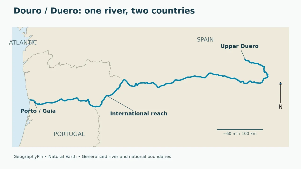
The Douro and Duero are the same river: Douro is its Portuguese name and Duero its Spanish name. It rises in Spain, crosses the northern interior of the Iberian Peninsula, follows part of the Spain–Portugal border, then flows through northern Portugal to the Atlantic beside Porto and Vila Nova de Gaia.
How to use this article: Trace the course, compare river lengths and border reaches, or distinguish the wine landscape.
1. Where is the Douro River?
The Douro River lies in Spain and Portugal, not just in the Portuguese wine valley often pictured beside its name. Its headwaters are in the Sierra de Urbión in Spain’s Iberian mountain system. From there, the river follows a generally westward route across the northern interior of the peninsula before reaching Portugal’s Atlantic coast.
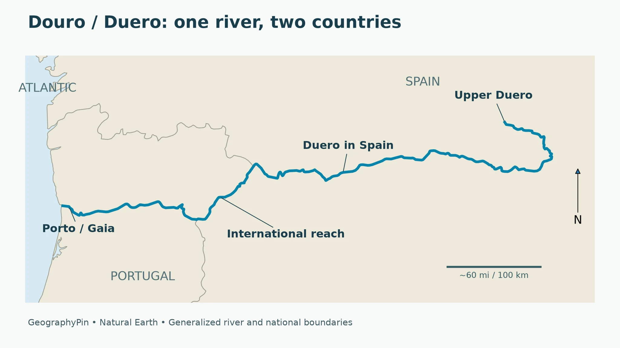
Read the course in three parts
A useful way to follow the map is to separate the Spanish interior, the international reach and the Portuguese lower course. These are parts of one connected river, not three different waterways. The border section is important, but it does not make the entire Douro an international boundary.
| Part of the course | Geographic setting | Key distinction |
|---|---|---|
| Upper and middle Duero | Spain, beginning in the Sierra de Urbión | The river exists well upstream of the Portuguese wine landscape |
| International reach | Along part of the Spain–Portugal frontier | The channel separates the countries here, rather than simply crossing the boundary once |
| Lower Douro | Northern Portugal, continuing toward Porto and Gaia | The river leaves the border and reaches the Atlantic through Portugal |
The outline of Spain and Portugal helps place the river, but a national map cannot show everything about its catchment. Streams begin on surrounding uplands and feed a larger drainage network. The blue channel on this map is the main river; it is not the perimeter of the land draining into it.
Duero or Douro: which name is correct?
Both are correct in their respective languages. A Spanish hydrological report normally uses Duero; a Portuguese source uses Douro. An English map may choose either form or show both. Changing the label does not create a second river, a confluence or a separate watershed.
This matters when matching maps with documents. A search for only one spelling can hide relevant information from the other country. It also explains why a description of the “Douro Valley” in a Portuguese visitor guide may cover a much narrower area than a Spanish account of the Duero basin.
2. How long is the river, and how much forms the border?
Portugal’s environment agency, APA, describes a total course of about 576 miles (927 kilometers) in its April 2022 draft nontechnical summary for the Douro river-basin management plan. That document divides the route into about 371 miles (597 kilometers) in Spain, 76 miles (122 kilometers) along the international boundary and 129 miles (208 kilometers) in Portugal.
Keep one source’s breakdown together
The three kilometer figures in APA’s description add to its total: 597 + 122 + 208 = 927. The border stretch is listed separately. Adding it again to the whole-river total would count the same channel twice.
These are the figures used here, attributed to that planning document rather than presented as a new measurement. They are not lengths calculated from the simplified map. A map designed to make the river readable at country scale leaves out small bends, so measuring its blue line would not reproduce a detailed agency survey.
Other institutional pages can describe a different spatial scope. For example, the Spanish Confederación Hidrográfica del Duero discusses the river and drainage network within its Spanish management context. A country-specific figure should not be compared with a complete source-to-ocean length without first checking the endpoints and whether an international reach is included.
A river border is not the whole frontier
Spain and Portugal share a much longer land boundary than this one river section. The Douro follows only part of it. Farther upstream, the Duero runs within Spain; farther downstream, the Douro runs within Portugal.
The international valley is also physically distinctive. Portugal’s official tourism description identifies the stretch between the Miranda do Douro area and Barca de Alva as a border reach with high escarpments and a narrow valley. That landscape is different from the open interior basin upstream and from the urban estuary at the coast.
3. What feeds the Douro, and why does its landscape change?
The river receives water from tributaries across a large international catchment. In Spain, the basin authority identifies the Pisuerga and Esla as major northern tributary networks. Rivers including the Tormes and Águeda enter the international part of the main river system.
Main channel versus drainage basin
A tributary is a river that feeds another river. A drainage basin includes the land supplying those channels, not simply the valley visible from the main riverbank. Rain falling away from the Douro can therefore still become part of its flow after moving through smaller streams and tributaries.
Our explanation of river parts and drainage basins shows how these pieces connect. The same distinction is useful here: a map of the main Douro channel is not a complete map of all the rivers, slopes and groundwater connections that influence it.
The Spanish basin authority describes an interior drainage area enclosed by mountain systems, with tributaries descending toward the main river. The Portuguese wine landscape, by contrast, is known for steep valley slopes modified by terraces. Near the sea, the river becomes part of an urban estuarine setting. These are successive geographic settings within one river system, rather than competing descriptions of what the Douro “really” looks like.
A regulated river, not an untouched channel
Dams and reservoirs have changed the Douro’s water surfaces and navigation conditions. Portugal’s official tourism account contrasts the historic river transport of wine with the later construction of dams. Present-day photographs can therefore show broad, relatively calm stretches even where the surrounding valley is steep.
A reservoir does not erase the identity of the river passing through it. It changes the water’s local storage and movement, while the main upstream-to-downstream connection remains. Conversely, seeing a reservoir or a boat on one reach does not prove that the entire river can be navigated continuously.
Lock openings, cruise departures, water levels and flood warnings require current information from the responsible authority or operator.
4. Is the Douro River the same as the Douro wine region?
No. The river is a watercourse, its basin is a drainage area, and a wine region is a geographically defined production or cultural landscape. The three are connected, but their boundaries are not interchangeable.
| Geographic term | What it describes | Why it matters |
|---|---|---|
| River | The connected watercourse called Duero or Douro | Two language names do not mean two rivers |
| Drainage basin | Land and tributaries supplying the river | A channel map is not a catchment boundary map |
| Wine landscape | A culturally shaped production area along part of the valley | Its designation does not cover the whole river |
Table downloads (2)
- Three geographic reaches of the same Douro–Duero river (4 × 3)View tableDownload CSV
- River, basin and wine landscape: different geographic scopes (4 × 3)View tableDownload CSV
What UNESCO actually recognizes
UNESCO lists the Alto Douro Wine Region as a cultural landscape. Its description emphasizes the river and tributary valleys, terraced vineyards and the long interaction between people and the terrain. The listed property is not the entire Douro River or every place inside its drainage basin.
That distinction avoids a common map-reading mistake. A photograph of vineyard terraces can accurately represent part of the Douro valley without showing what the headwaters, Spanish interior or estuary look like. Similarly, a map highlighting a World Heritage property should not be read as a map of the whole catchment.
The phrase “Douro Valley” is also used in tourism more loosely than a formal basin or protected-property boundary. When an article offers a valley itinerary, check the actual towns and reaches it covers rather than assuming that “Douro” means the full source-to-ocean route.
Why Porto and Gaia appear in wine descriptions
The connection between the inland vineyards and the coast helps explain the prominence of Porto and Vila Nova de Gaia. Portugal’s tourism authority describes the historic movement of wine downriver in rabelo boats and the lodges at Gaia where Port wine was aged.
This is a relationship between production landscapes, transport and an estuarine city setting. It does not place all the vineyards inside Porto, nor does it make the river’s source Portuguese. The same river can connect places that perform very different roles.
5. Where does the Douro reach the ocean?
The Douro reaches the Atlantic Ocean at the Porto–Vila Nova de Gaia coast. The two cities face one another across the lower river: Porto is on the northern side and Gaia on the southern side. Foz do Douro is the Porto-side mouth area, not another river arriving from inland.
Coast, estuary and upriver valley
An estuary is the coastal transition where river water meets the sea. That makes the river mouth different from an upstream reservoir or a vineyard valley, even though all three can appear in photographs captioned “Douro.”
On a map, follow the river west from inland Portugal until its channel reaches the Atlantic coastline. Do not stop at the name Porto and assume the entire urban riverfront is the precise mouth. The city’s lower-river setting includes reaches upstream of the opening to the ocean.
For broader orientation, our physical map of Europe places Iberian rivers within the continent’s larger pattern of uplands, plains and coastal outlets. The Douro is an Atlantic-draining river, while other Iberian rivers take different routes to the sea.
Frequently Asked Questions
Are Douro and Duero different rivers?
No. Douro is the Portuguese name and Duero the Spanish name for the same river. Different labels on national maps do not indicate separate watercourses.
Does the Douro begin in Portugal?
No. It rises in Spain’s Sierra de Urbión. After crossing the Spanish interior and following an international reach, it continues through northern Portugal.
How much of the Douro forms the border?
APA’s April 2022 draft planning summary describes about 76 miles (122 kilometers) as an international reach, within a total river length of about 576 miles (927 kilometers). These are source-specific approximate figures.
Does the Douro flow through Lisbon?
No. It reaches the Atlantic beside Porto and Vila Nova de Gaia in northern Portugal. Lisbon is not on the Douro.
Is the entire Douro River a UNESCO World Heritage Site?
The Alto Douro Wine Region designation concerns a particular cultural landscape, not the entire river or every place in its drainage basin. Read the property’s mapped extent rather than treating its name as a whole-basin label.
What Did We Learn Today?
Douro and Duero name one river. It begins in Spain, follows only part of the Spain–Portugal frontier, and reaches the Atlantic at Porto and Gaia. Its channel, drainage basin and wine landscape are related but different geographic entities. Source-specific lengths and clearly defined map layers keep those distinctions visible.
Sources & Data Notes
Lengths follow APA’s April 2022 draft planning summary; miles are rounded conversions. Original maps use generalized Natural Earth river and country geometry, not measured basin or wine-region boundaries. Small multipart gaps are retained. The maps are not navigation charts or current water-level information.
- Confederación Hidrográfica del Duero: basin characteristics: Spanish drainage context, tributary networks and international hydrological demarcation.
- APA: Douro RH3 draft nontechnical summary, April 2022: PDF page 4: source in Sierra de Urbión and 927-kilometer course divided into 597, 122 and 208 kilometers. Used for geographic reference, not current operational status.
- Turismo de Portugal: The Douro Valley: International valley, Porto/Gaia setting, historic river transport and dam context. No itinerary, price or timetable is reproduced.
- UNESCO: Alto Douro Wine Region: The listed cultural landscape, distinct from the entire river and basin.
- Natural Earth: public-domain data: Original GeographyPin map compositions use generalized 1:10 million river and country geometry.