The Vistula links Poland’s southern mountains with its Baltic coast, but it does not run north in a straight line. Following its bends explains why Kraków, Warsaw and the Gdańsk region belong to the same river story while occupying very different landscapes.
The Vistula, called Wisła in Polish, is Poland’s longest river. Its headwaters rise on Barania Góra in the Silesian Beskids, and its main course runs through Poland to the Gulf of Gdańsk in the Baltic Sea. Kraków and Warsaw lie on the river; its principal modern outlet is east of central Gdańsk.
1. Where is the Vistula River?
Trace the blue line, not the nearest coastline
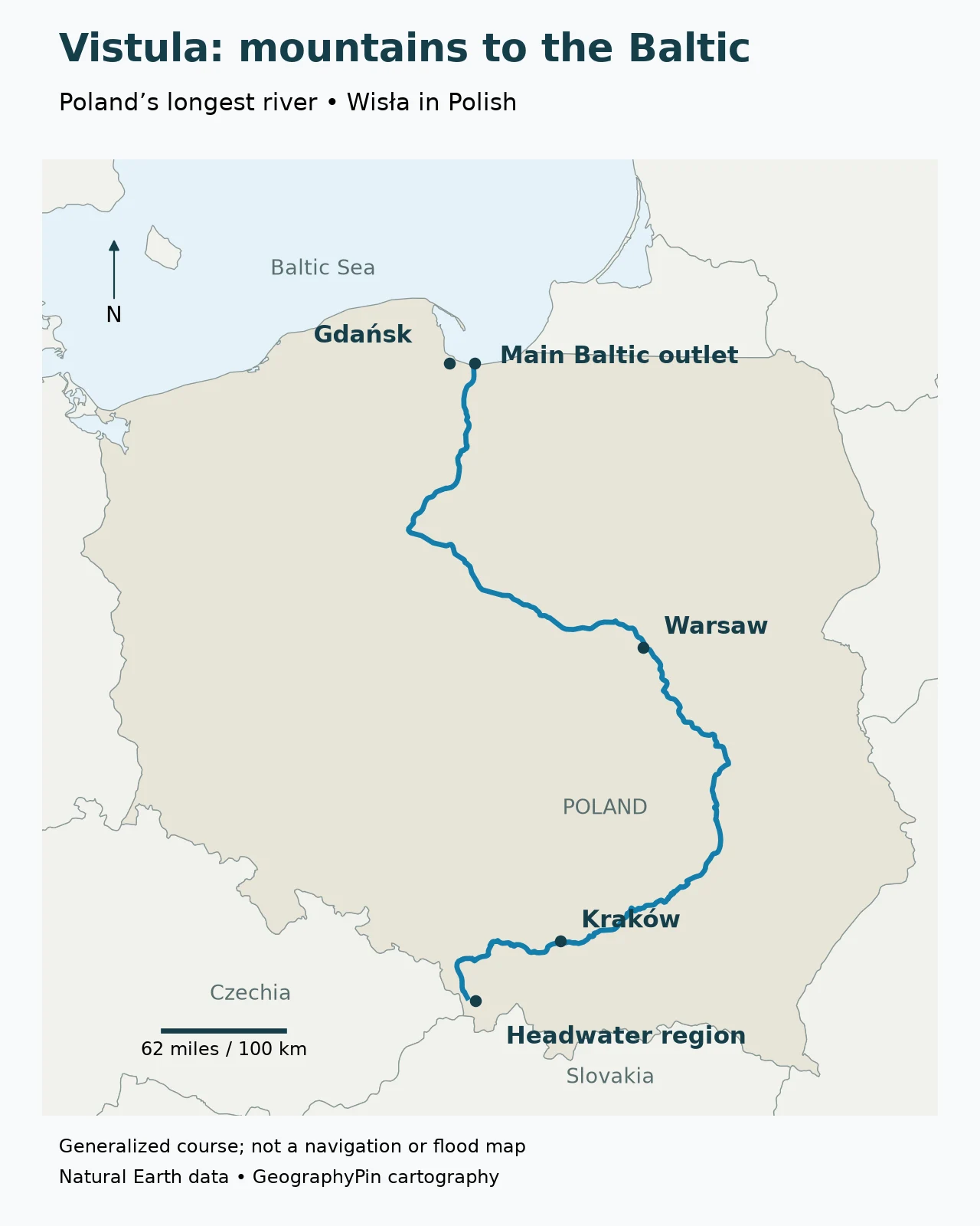
The main river is entirely in Poland. It starts in the south, travels eastward through the Kraków region, turns broadly north toward Warsaw, then bends northwest before reaching the Baltic coast. “South to north” is a useful overall description, but the bends are essential to its actual course.
The conventional length given by Poland’s educational geography portal is approximately 650 miles (1,047 kilometers). Treat this as a reference length, not a measurement obtained from this map: a generalized line omits small bends, and published river lengths can differ with the chosen course, endpoints and measurement method.
| Question | Answer |
|---|---|
| Local name | Wisła |
| Country of the main course | Poland |
| Headwater region | Barania Góra, Silesian Beskids |
| Receiving sea | Gulf of Gdańsk, part of the Baltic Sea |
| Conventional length | About 650 miles (1,047 kilometers) |
| Two major cities directly on the river | Kraków and Warsaw |
| Main modern outlet | Vistula Cut near Świbno, east of central Gdańsk |
The distinction between a river and its basin matters here. The main channel is one connected course. The basin is the land draining toward it through many streams and tributaries. A country containing the whole main channel does not necessarily contain every part of the wider drainage system. For those basic terms, see what a river is and how its parts fit together.
2. From the Beskids to Poland’s lowlands
A mountain headwater network, not one line on a hillside
The source region is on Barania Góra in the Silesian Beskids, part of the Carpathian mountain system. The names Biała Wisełka and Czarna Wisełka refer to important headwater streams. The State Archives in Katowice describes the beginning of the Vistula through the joining of those streams with the Malinka. This is more informative than placing an unexplained “source” dot at an apparently exact coordinate.
A river’s named beginning, its most distant headwater and a particular spring are not always the same cartographic object. The map therefore labels a headwater region. It does not claim that the simplified Natural Earth line begins at a surveyed spring or follows every small mountain stream.
Kraków and Warsaw along the same river
Kraków is the first of the two large city anchors shown here when following the river downstream. The river has already left its mountain headwaters before reaching the city. Farther along, the long northward section carries it toward Warsaw, where the river is a major feature of the capital’s urban landscape.
The course then changes direction again. Downstream of Warsaw it trends northwest across the lowlands before turning toward the coast. This broad bend is easy to miss in a schematic “mountains to sea” diagram. The geographic map retains it, so readers can place the river correctly relative to the shape of Poland.
The named cities are orientation points, not a complete itinerary. A course map answers where the river runs; it does not establish that every stretch is navigable, has a continuous riverside path or can be safely visited from the nearest road. Those questions need local information at a much finer scale.
3. Tributaries and the wider river system
The main channel does not collect all its water alone
The Vistula receives water from tributaries on both sides. Among the well-known direct tributaries are the Dunajec, San, Wieprz, Narew and Pilica. Their valleys connect the main river to landscapes far from the blue line on the map. This is why conditions along a large river cannot be understood solely by looking at rain falling beside one city.
| River | Relationship to the Vistula | Useful distinction |
|---|---|---|
| Dunajec | Direct tributary | A southern mountain-fed branch of the wider system |
| San | Direct tributary | Joins the main river from the southeast |
| Wieprz | Direct tributary | Part of the eastern tributary network |
| Pilica | Direct tributary | A left-bank tributary when facing downstream |
| Narew | Direct tributary | The river through which the Bug’s water reaches the Vistula |
| Bug | Tributary of the Narew | Part of the Vistula system, but not named as a separate direct tributary at the Vistula confluence |
Left bank and right bank are defined while facing downstream. They do not mean the left and right edges of a north-up map. Because the Vistula bends, a compass direction alone is not a reliable way to label a tributary’s bank.
The Bug–Narew connection is an especially useful example of river naming. Poland’s educational portal explicitly identifies the Bug as a tributary of the Narew. A long branch can be important to the system without taking over the downstream river’s name. Names, lengths and drainage relationships answer related but different questions.
The map deliberately keeps tributaries out of the main-course graphic rather than drawing approximate connections by hand. The table explains selected relationships without pretending to be a complete hydrological network. A basin-boundary map would be a different product and should be built from an appropriate watershed dataset, not from Poland’s national outline.
4. Where the Vistula meets the Baltic
The main outlet is not the center of Gdańsk
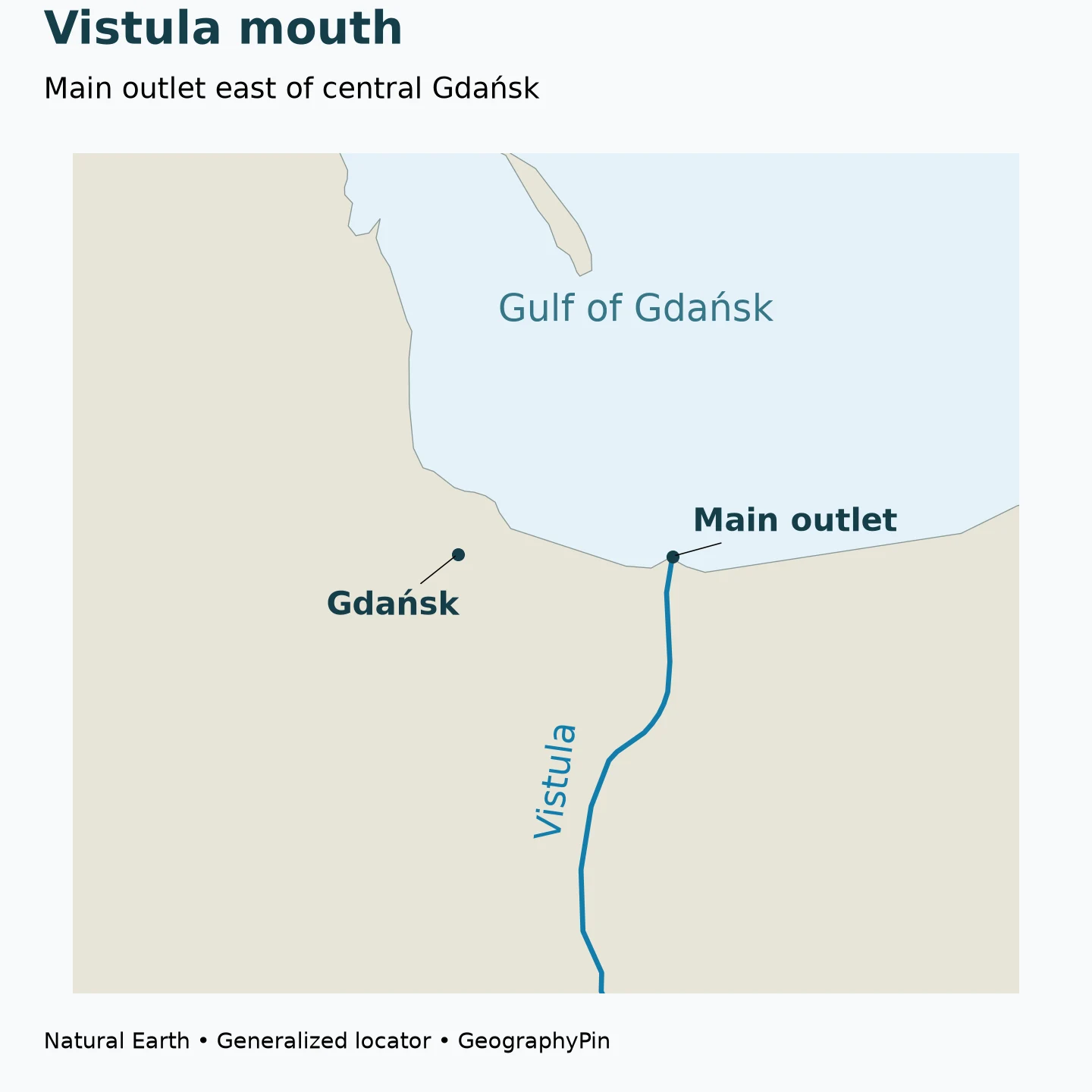
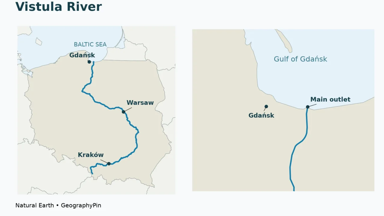
The Vistula reaches the Gulf of Gdańsk, an inlet of the Baltic Sea. Describing its mouth simply as “Gdańsk” gives the general region, but can mislead a reader who imagines the main river flowing directly through the historic city center into the sea.
The principal modern outlet is the Vistula Cut, or Przekop Wisły, near Świbno. It opened in 1895, as described in Poland’s educational geography reference. The river’s lower landscape also contains branches and older channels associated with its delta, including the Nogat and Szkarpawa. The current main outlet and the wider delta are therefore not interchangeable labels.
This is a useful example of a landscape that is both natural and engineered. Rivers carry sediment toward the sea and build or reshape low-lying coastal land, while people modify channels, outlets and flood defenses. A modern river mouth can be deliberately cut even though the larger delta landscape developed over a much longer period.
Gdańsk remains a key geographic reference for the coast, but the city point and the mouth point are separate on the map for a reason. The distinction becomes important when comparing a historical map, a port map and a present-day map of the main river course: they may emphasize different channels without necessarily describing the same object.
5. A river shaped by both nature and people
The Vistula is not equally mountainous, urban or engineered along its entire length. Its upper headwaters, lowland reaches, city waterfronts and coastal outlet have different forms. A claim that the whole river is either completely wild or completely regulated would flatten those differences.
The State Archives’ account of the upper river documents the Goczałkowice reservoir and its roles in water supply and flood protection. At the other end of the river, the artificial Baltic outlet provides a different example of engineering. These are distinct interventions at different places, not evidence that every reach has the same channel form or purpose.
Water level also changes over time. A low reading at a river gauge is not the river’s total depth everywhere, and a high reading at one station is not a flood map for the whole basin. Station location, the reference datum and the measurement being reported all matter. Our guide to river gauges, stage and flow explains those differences.
For current conditions, use Poland’s Institute of Meteorology and Water Management, IMGW’s hydrological observations, and the relevant Wody Polskie navigation notices. This geographic profile does not provide a current flood forecast, boating clearance or safe swimming location.
Frequently Asked Questions
Are Vistula and Wisła different rivers?
No. Vistula is the English name and Wisła is the Polish name for the same river. Local signs and Polish maps normally use Wisła.
Is the Vistula longer than the Oder?
Yes. The conventional lengths listed by Poland’s educational geography portal are about 650 miles (1,047 kilometers) for the Vistula and 531 miles (854 kilometers) for the Oder’s full course. The Oder’s total length should not be confused with only its Polish section.
Does the Vistula flow into the North Sea?
No. It enters the Gulf of Gdańsk in the Baltic Sea. The Baltic is connected to the North Sea through the Danish straits system, but that does not make the North Sea the Vistula’s immediate receiving sea.
Can this map show whether my property is in a flood zone?
No. It is a small-scale course map. Property-level flood assessment requires official hazard mapping and local information; proximity to the line alone is not enough.
What Did We Learn Today?
The Vistula, or Wisła, is Poland’s longest river, linking the Silesian Beskids with the Baltic through a winding course that passes Kraków and Warsaw. Its tributaries form a wider system than the main channel alone, and the Bug reaches that system through the Narew. At the coast, the principal modern outlet is an engineered cut east of central Gdańsk, so the main mouth, the delta and the city should not be treated as the same place.
Sources & Data Notes
- Poland’s Zintegrowana Platforma Edukacyjna: surface and groundwater: conventional river lengths, headwater region, Baltic outlet and Bug–Narew relationship.
- ZPE: river networks of Poland: tributary relationships and downstream bank terminology.
- State Archives in Katowice: At the Sources of the Vistula: headwater streams and the history of upper-river engineering.
- Polish Tourism Organisation: Warsaw and Kraków: city–river context.
- Natural Earth: public-domain river centerlines, country outlines and representative city points.
Map method: Original GeographyPin cartography uses Natural Earth’s 1:10m river and country data, projected in Poland CS92 (EPSG:2180). The blue line is a generalized river centerline, not a measured bank, navigation track or flood boundary. The headwater-region marker is approximate; the mouth marker follows the mapped main-channel endpoint. City points are representative locations rather than municipal boundaries. The mouth locator omits secondary delta channels rather than inventing detailed geometry.
Measurement note: About 650 miles (1,047 kilometers) is the conventional reference length used here. It is not calculated from the map and should not be treated as an exact survey result. Different waterway references can use different endpoints and length conventions. No new basin-area or discharge estimate has been calculated for this article.