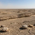
A deflation hollow is a shallow ground depression formed when wind lifts and carries away loose sediment from the surface (a process called deflation).
You’ll see them most often where sand, silt, or dust is exposed and vegetation is sparse—deserts, dry lakebeds, sand sheets, and dune fields.
Despite the name, this “deflation” has nothing to do with economics.
Direct answer
A deflation hollow is a wind-eroded depression that forms when persistent winds remove loose surface sediment faster than it’s replaced. Over time, the hollow may stabilize when it reaches a “base level” (like a tougher layer, an armoured gravel surface, or the water table), while some of the removed sand piles up downwind.
How to use this article: For quick identification, jump to the fast check; for “what it is vs what it isn’t,” use common mix-ups; for look-alikes, go to the comparison table; for short answers, skip to FAQ.
What Is a Deflation Hollow?
A deflation hollow forms when wind repeatedly “winnows” a surface—picking up the smaller, lighter grains and leaving the ground slightly lower than the area around it.
The key idea is removal: the hollow is carved mainly by wind taking material away, not by wind piling a dune on top.
In real landscapes, erosion and deposition often happen together. A hollow can deepen upwind while sand accumulates downwind as a low mound, a dune tongue, or a more organized depositional lobe—especially in dune terrain where airflow can focus through the depression.
Where you’ll likely encounter them: dry, open surfaces with loose sediment and limited plant cover—desert plains, dry lakebeds, sandy coasts, and disturbed sandy ground.
The same physics can operate outside deserts too (for example, on exposed fields during dry, windy periods), but the landform “signature” is clearest in arid and coastal dune settings.
Fast Check: How to Recognize One
Fast check in 30 seconds
Use this quick checklist. You don’t need instruments—just pattern recognition and context.
- Depression with a “scoured” feel: the floor looks swept, sometimes tighter-packed than the surroundings.
- Coarser leftovers: pebbly/gravelly lag or “armour” on the floor (wind removed fines; heavier bits stayed).
- Downwind clue: a small sand build-up or lobe downwind is common in sandy terrain.
- Vegetation pattern: plants may be thinned/absent in the center but thicker on sheltered margins.
- Setting makes sense: open fetch, loose sediment supply, and ongoing wind exposure.

One reliable clue is “stopping behavior.” Deflation hollows often deepen until they hit a limit: a tougher layer, an armoured surface of grains too heavy to move, or a moist/wet base level like the water table in some dune systems.
That’s why some hollows look sharply defined even if they’re not actively deepening every day.
Deflation Hollow vs Blowout vs “Deflation Basin”
These terms overlap, and different books use them slightly differently. The safest way to read them is by process first and scale/setting second.
Deflation hollow is the plain-language label: a hollow produced by wind deflation.
Blowout is often used for the same feature in sandy dune terrain, especially when the hollow has distinct walls and a clear downwind depositional lobe.
Deflation basin is commonly used when the feature is larger, longer-lived, or described at landscape scale.
What it is not: the most common mix-ups
If you’re unsure, use these quick tie-breakers. They’re designed for field observation (or good aerial imagery), not lab tests.
- Impact crater: usually shows a raised rim and ejecta patterns. A deflation hollow is more “swept” than “blasted.”
- River-cut gully: typically shows branching channels and clear flow paths. Wind hollows don’t form a channel network.
- Karst sinkhole: often ties to soluble bedrock and internal drainage. Wind hollows tie to loose sediment and exposure.
Final check: (1) does the setting support persistent wind removal, and (2) is there any downwind sand accumulation pattern that matches the hollow?
How Wind Makes a Hollow (Step by Step)
Wind erosion works in two main ways: deflation (lifting and removing loose grains) and abrasion (sandblasting surfaces with moving grains).
A deflation hollow is mainly about removal, while abrasion can sharpen details around it (and help create wind-shaped stones called ventifacts).
1) Start with exposed, moveable sediment
The starter condition is simple: loose sand/silt/dust at the surface with limited vegetation protection.
That can be natural (dry lake margins, sand sheets, dune fields) or triggered by disturbance (trampling, vehicle tracks, overgrazing, vegetation removal).
2) Winnowing removes the fines first
As wind energy increases, the smallest grains are easiest to lift and carry (often in suspension).
Sand often moves by short hops (saltation), while heavier grains move by surface creep. The surface lowers unevenly, and a shallow hollow appears where removal is strongest.
3) The floor armours and the hollow “organizes”
As fines leave, the remaining coarser grains can form an armoured lag that is harder for the wind to move.
This is why many deflation surfaces develop a stony, pavement-like look, and why hollows often stabilize once the floor becomes protected.
4) A base level eventually limits deepening
Deflation usually doesn’t continue forever. It slows or stops when the hollow hits a limit: a more consolidated layer, an older soil horizon, an armoured lag surface, or (in some dune settings) moisture/water table conditions.
After that, the hollow may widen, migrate slightly, or shift shape with changing wind directions rather than simply getting deeper.
5) Downwind deposition is the “shadow” of the hollow
Material removed from the hollow has to go somewhere. In sandy terrain, a portion often deposits downwind as a lobe or dune feature because airflow slows and drops its load.
That pairing—erosional hollow plus downwind sand build-up—is one of the cleanest patterns to look for.
Look-Alikes: A Quick Comparison Table
Many depressions look similar from a distance. This table keeps it non-numeric and field-friendly.
Comparison table: deflation hollow vs similar features
| Feature | Main process | Fast field clue | Typical context |
|---|---|---|---|
| Deflation hollow / blowout | Wind removes loose sediment (deflation) | Scoured floor + coarse lag/armour; often a downwind sand lobe | Deserts, dry lakebeds, sand sheets, dunes, disturbed sandy ground |
| Karst sinkhole | Dissolution/collapse in soluble bedrock | Often circular; may have internal drainage and rock/limestone context | Karst terrain (limestone/dolomite/gypsum), not primarily sandy surfaces |
| Gully | Running water concentrates and cuts channels | Branching channels; clear flow paths; sediment fans downslope | Slopes after storms, bare soils, drainage lines |
| Kettle hole (glacial) | Melting of buried ice blocks | Common in glacial deposits; often wetland/lake; irregular clusters | Former glaciated landscapes with outwash/till |
| Yardang corridor (near yardangs) | Wind abrasion/deflation sculpts ridges and troughs | Streamlined ridges aligned with prevailing wind; repeating pattern | Arid basins with more consolidated material |
| Human excavation (borrow pit/quarry) | Mechanical removal | Sharp edges, tracks, spoil piles, straight lines, easy access points | Near roads, construction zones, mining areas |
If you only remember one rule: wind hollows pair well with wind patterns—open fetch, scoured/armoured floors, and (often) a downwind depositional “shadow.”
If the context screams water flow, bedrock dissolution, or machinery, treat “deflation hollow” as unlikely.
Why It Matters: Dust, Soil Loss, and Dune Stability
In many deserts and dune fields, deflation hollows are simply part of how wind landscapes “breathe” over time—eroding here, depositing there.
But in the wrong place, the same process can signal land degradation: valuable fine particles (including topsoil-sized material) can be removed and transported far beyond the site. Over long distances, that dust can settle as fine blankets sometimes described as loess.
In coastal dunes, blowouts/deflation hollows often start with a break in vegetation cover. Once plants are disturbed, airflow can accelerate through the opening, increasing erosion and expanding the hollow.
That’s why managers focus on keeping dune plants intact and limiting repeated trampling or off-road traffic in sensitive dune areas.
If you’re trying to reduce wind erosion on working land, the practical direction is consistent: keep soil protected.
- Maintain ground cover (living plants or residue).
- Reduce disturbance of dry, bare surfaces when winds are likely.
- Use windbreaks where practical.
- Keep surface roughness (micro-relief) so wind can’t sweep the ground as efficiently.
FAQ
Is a deflation hollow the same thing as a blowout?
Often, yes—especially in sandy dune environments. “Blowout” is commonly used when the hollow has clear erosional walls and a downwind depositional lobe. Some authors use “deflation basin” for larger versions, but the core process is the same: wind removal.
What makes the hollow stop getting deeper?
A limit is usually reached—an armoured lag surface that wind can’t move easily, a more consolidated layer, or moisture/water table conditions that reduce further deflation. After that, the hollow may widen or shift shape rather than deepen.
Can deflation hollows form outside deserts?
Yes. Wind can erode any exposed, dry, fine sediment if vegetation cover is low and winds are strong enough. The clearest examples are in deserts and dunes, but the same deflation physics can operate on other open, disturbed sediment surfaces.
How is a deflation hollow different from a sinkhole?
A sinkhole is usually tied to bedrock dissolution and collapse (karst). A deflation hollow is tied to wind removing loose sediment. If the geology is soluble bedrock and the depression shows internal drainage, “sinkhole” becomes more likely than “deflation hollow.”
Do deflation hollows create dunes?
They can be paired with dunes. Sand removed from a hollow may deposit downwind where airflow slows, building a lobe or dune feature. That erosion–deposition pairing is common in dune fields.
Are deflation hollows “bad” for the environment?
Not automatically. In natural dune and desert systems, they’re normal landforms. They become a concern when they signal accelerating soil loss, repeated disturbance of stabilizing vegetation, or increased dust emission affecting nearby ecosystems and people.
What Did We Learn Today?
A deflation hollow is a wind-eroded depression formed by the removal of loose surface sediment. The fastest ID clues are a scoured or armoured floor, a setting with exposed sediment and strong winds, and—often—a downwind sand build-up. The most common confusion is with sinkholes and gullies, which come from different processes and usually show different landscape context.
Sources & Data Notes
This article follows standard geomorphology explanations of aeolian (wind) erosion: deflation removes loose fine material, abrasion can sharpen surfaces, and hollows in sandy terrain are often described as deflation hollows or blowouts. Definitions and preferred terms vary across USGS-style public education materials, national park geology references, and geomorphology texts; the piece avoids exact size thresholds and uses qualitative field cues instead. Where “stopping depth” is mentioned, it’s treated as a base-level concept (armour, consolidated layer, or moisture/water table) that can differ by site.