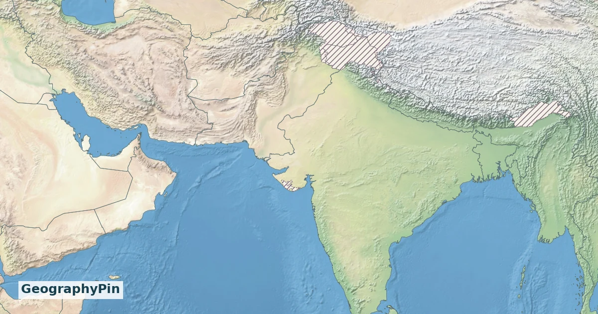
A South Asia countries map needs a definition as well as borders. Some lists show eight countries; the United Nations statistical grouping shows nine. The difference is easier to understand when Iran’s classification, Afghanistan’s position and the region’s physical geography are kept separate.
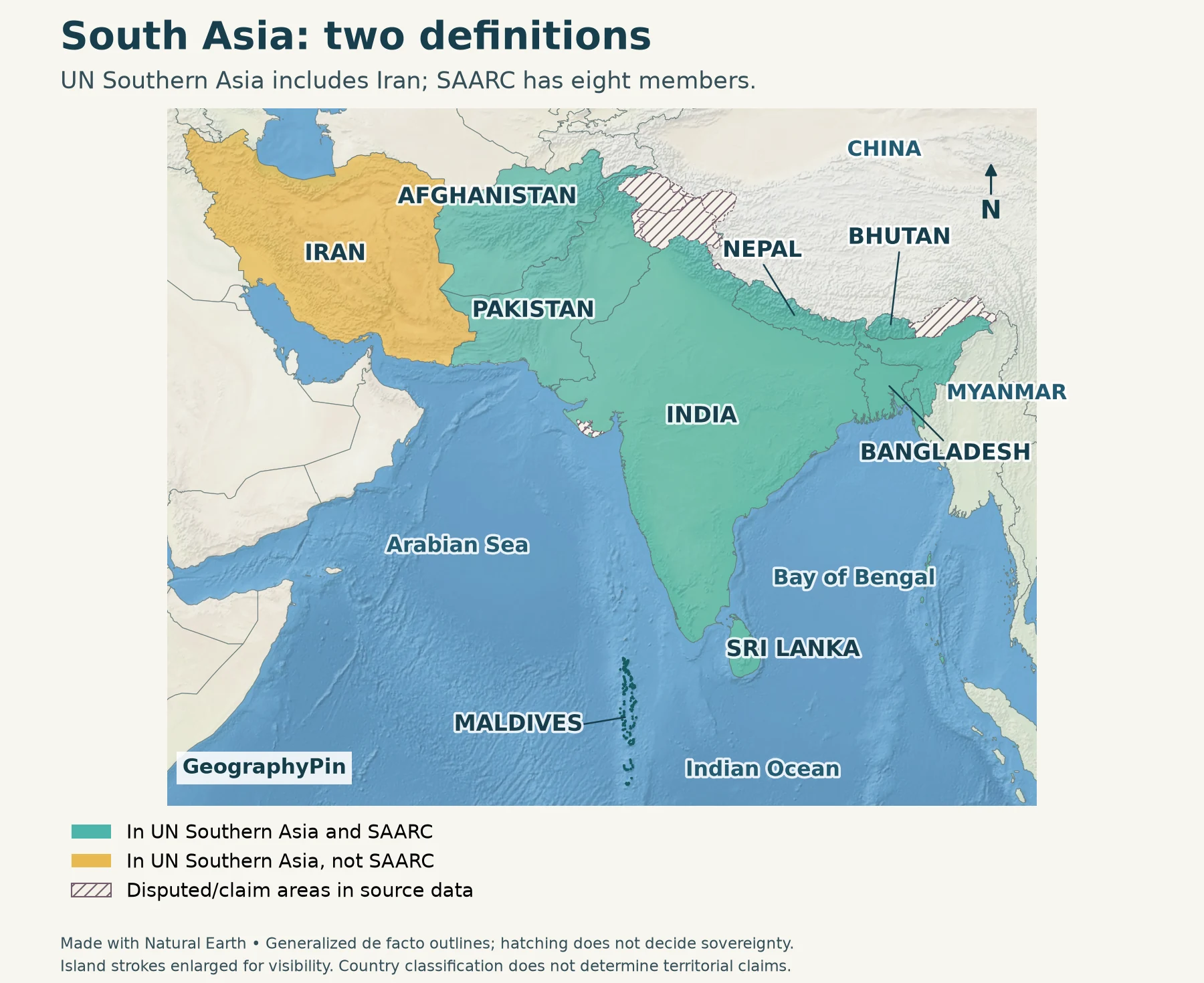
Under the UN M49 statistical scheme, Southern Asia comprises Afghanistan, Bangladesh, Bhutan, India, Iran, Maldives, Nepal, Pakistan and Sri Lanka. SAARC’s eight-member list includes all of these except Iran. This map uses the UN grouping and highlights the difference, rather than treating either list as the only possible meaning of South Asia.
How to use this article: Compare the two lists, find Iran and Afghanistan, or read the river plains.
1. Read the South Asia Countries Map
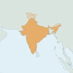
Start with India’s southward-projecting peninsula. Pakistan lies to its northwest, Nepal and Bhutan along the Himalayan margin, and Bangladesh near the head of the Bay of Bengal. Sri Lanka is an island southeast of India’s southern tip; the Maldives form an island chain to the southwest.

Country key for the numbered mobile map: 1 Afghanistan; 2 Bangladesh; 3 Bhutan; 4 India; 5 Iran; 6 Maldives; 7 Nepal; 8 Pakistan; 9 Sri Lanka.
The Arabian Sea is west of the Indian peninsula and the Bay of Bengal is east of it. Both open into the Indian Ocean. Iran extends the selected statistical region farther west; Afghanistan occupies its northwestern interior. China and Myanmar are shown only for orientation, not included in the regional count.
Tiny islands cannot be shown at the same visual weight as a large mainland country. The Maldives’ outlines are emphasized for visibility; that does not enlarge their actual land area. The map does not draw territorial seas, exclusive economic zones or a boundary around a South Asian political bloc.
2. Why Country Lists Differ
A statistical region is not an organization
The UN Statistics Division’s M49 scheme assigns countries and areas to regions for statistical use. Its “Southern Asia” category supplies the reference list here. The UN explicitly says those assignments do not imply political affiliation.
The South Asian Association for Regional Cooperation, or SAARC, is an intergovernmental organization. Its Secretariat lists eight member states. Membership answers a different question from a physical-geography map: an organization’s roster does not establish the limits of a mountain system, river basin or cultural region.
| Country | UN Southern Asia | SAARC member |
|---|---|---|
| Afghanistan | Yes | Yes |
| Bangladesh | Yes | Yes |
| Bhutan | Yes | Yes |
| India | Yes | Yes |
| Iran | Yes | No |
| Maldives | Yes | Yes |
| Nepal | Yes | Yes |
| Pakistan | Yes | Yes |
| Sri Lanka | Yes | Yes |
Why Iran and Afghanistan need a qualifier
Iran is the difference between these two lists. Describing it as part of the Middle East in another context does not contradict its placement in UN Southern Asia: those labels serve different purposes. A clear map names its system instead of silently changing the membership halfway through.
Afghanistan is included in both lists. Its connections across the northwestern highlands also explain why it is discussed in relation to Central Asia. Regional relationships can cross the neat lines of a statistical table. For the country itself, see the Afghanistan profile; this page focuses on its regional position rather than repeating a national overview.
The Indian subcontinent is another term to handle separately. It emphasizes a broad physical and historical region within Asia, not the modern country of India alone and not automatically every state in the UN table. Our India-in-Asia explainer separates the country, subcontinent and tectonic plate.
3. Mountains, Plains and Surrounding Seas

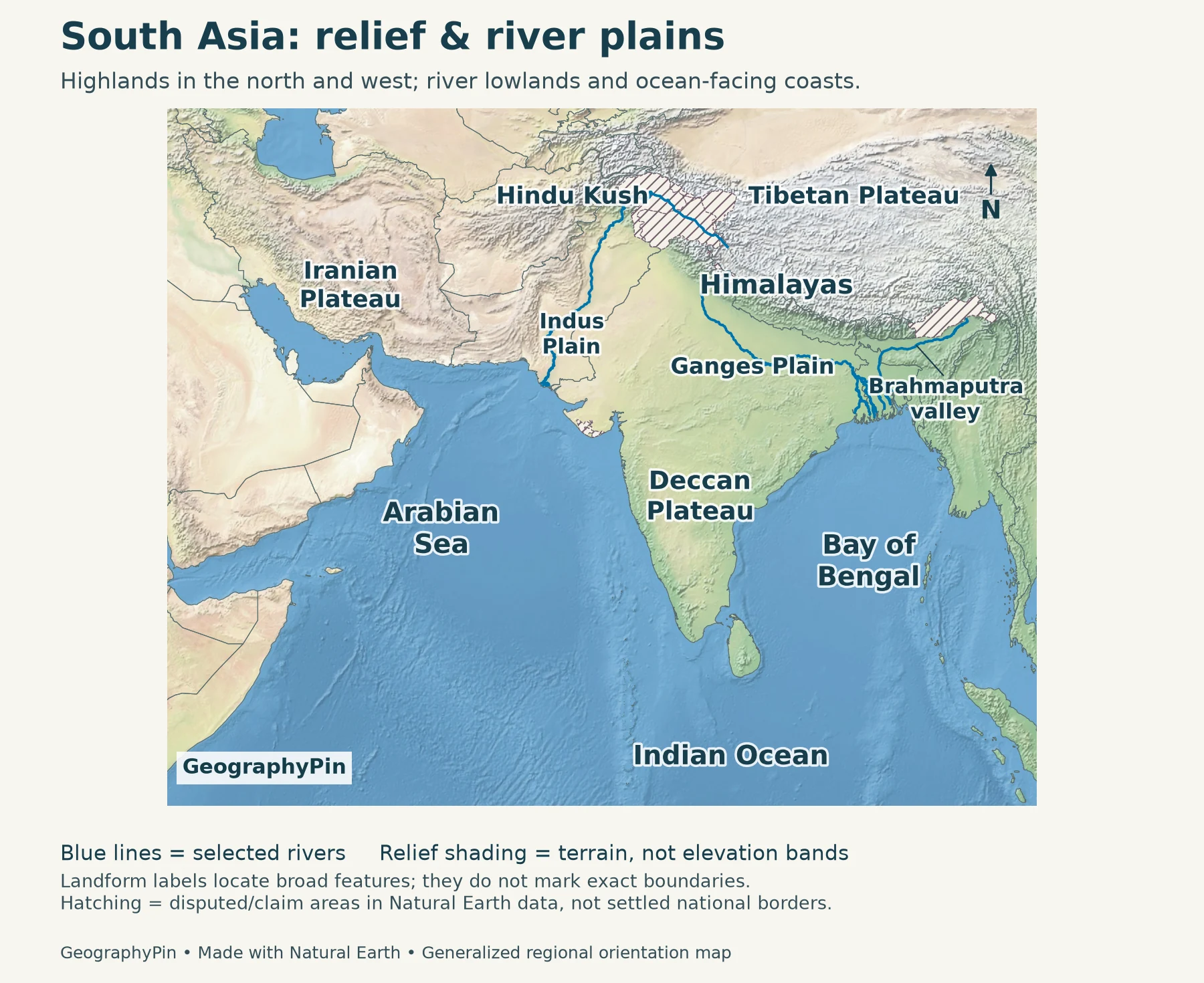
Landform key for the numbered mobile map: 1 Iranian Plateau; 2 Hindu Kush; 3 Himalayas; 4 Indus Plain; 5 Ganges Plain; 6 Deccan Plateau.
The northern and western highlands
The Himalayas form the conspicuous mountain arc along the northern side of the Indian subcontinent. Nepal and Bhutan sit within this mountain-and-foothill setting. The Tibetan Plateau lies beyond the range to the north. Farther northwest, the Hindu Kush is a major feature of Afghanistan, while Iran brings plateau and mountain landscapes into the wider UN-defined region.
These are not interchangeable names for one continuous national boundary. A mountain range is a landform; a state border is a political line. Reading the relief beneath the outlines helps explain why a country can contain both high mountains and low plains.
The river plains below the mountains
South of the Himalayan arc, broad lowlands connect the Indus and Ganges river landscapes. The Indus system leads toward the Arabian Sea through Pakistan. The Ganges and Brahmaputra systems lead toward the Bay of Bengal through the eastern lowlands and Bangladesh. River plains are shaped by sediment deposition, not by membership in a regional organization.
The map deliberately shows selected river courses rather than every tributary. A blue line is a river, not a drainage-basin boundary. Likewise, “Indus Plain” and “Ganges Plain” label broad physical features; they should not be read as the total area drained by those rivers.
The peninsula and island countries
The Deccan Plateau occupies much of peninsular India south of the northern plains. The coastlines on either side face different parts of the Indian Ocean. Sri Lanka and the Maldives add distinct island settings to a region that is often pictured only as a mainland block.
No single landscape describes all nine countries. A relief map that includes Iran and Afghanistan must extend well beyond the familiar triangular outline of India. Conversely, a map focused only on the subcontinent should not be mistaken for the full UN statistical region.
4. How to Read the Borders
The country outlines use Natural Earth’s generalized de facto cartography, with disputed and claim areas from its separate dataset hatched and outlined with dashed lines. This is a regional orientation map, not a legal determination of sovereignty or a detailed operational map of control.
The Kashmir region and parts of the India–China frontier require particular care. Do not interpret the regional colors as resolving those disputes. Hatching interrupts the country colors precisely so that a small-scale locator does not present contested areas as unqualified, settled territory.
Classification and borders are separate decisions. Listing India, Pakistan or China in a particular UN subregion does not determine their territorial claims. A source-defined regional count can be clear even where a political boundary is contested. The Asia countries and capitals reference explains the wider counting convention without turning this map into a continent-wide directory.
Frequently Asked Questions
Is Myanmar part of South Asia on this map?
No. UN M49 places Myanmar in South-eastern Asia, and it is not on the SAARC member list. Its presence beside Bangladesh and India on the map provides neighboring-country context.
Does South Asia have its own international border?
No. It is a regional label, not a sovereign state. International borders separate the countries; a regional grouping collects countries according to a stated convention.
Can I compare a South Asia statistic with a Southern Asia statistic?
Only after checking their country coverage and measurement method. If one includes Iran and the other excludes it, the totals do not describe the same set of places, even if both labels sound similar.
What Did We Learn Today?
Reading South Asia starts with three separate layers: the chosen country grouping, the physical landscape and the treatment of borders. The UN list and SAARC roster differ over Iran; neither replaces the mountain, plain and island geography beneath them. A useful regional map makes those distinctions visible instead of hiding them behind an unexplained country count.
Sources & Data Notes
The country comparison uses UN M49 Southern Asia and the SAARC Secretariat’s member list. Maps are original GeographyPin compositions from public-domain Natural Earth terrain, country outlines, rivers and disputed-area data. Outlines are generalized and follow the source’s de facto convention; hatching is not an endorsement of a territorial claim. Physical-feature labels locate broad landscapes, not measured boundaries. Island strokes are emphasized for visibility.
- United Nations Statistics Division: M49 regional classification
- SAARC Secretariat: member states
- National Geographic Education: Asia’s physical geography
- Khan Academy / Smarthistory: Geographic regions of South Asia
- Encyclopaedia Iranica: Hindu Kush geography
- Natural Earth: public-domain data and boundary policy