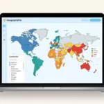
Color countries, add a legend and download your map. Free, with no account required.
Make your map in four steps
- Color countries. In Countries, choose a color group. Search for countries, click the map or paste a list and apply it. Review any unmatched names.
- Build the legend. Name your color groups in their settings. Open Legend to change its appearance; select an entry to edit its name or color.
- Customize the map. Open Style to choose the world, a continent or a region. Add a title and choose which country names to show.
- Download or save. Open Download, choose PNG, SVG or WebP and save your image. Apply or discard unfinished lists first. Save a project file to edit later.
Adding countries: search, paste or click
Paste country names separated by commas, semicolons or new lines. Two- and three-letter country codes also work. Check any names the editor cannot identify before applying your list.
In Countries, search for names and add your selection to the active color group. You can also click the map: click a country again to remove its active color. Search is useful for small islands. In Legend, Style and Download, the map is for inspection and clicks do not change its colors.
Editing a country list? Applying a revised list removes countries you deleted from that group’s list.
If a name is not recognized, review the proposed additions and removals before choosing whether to apply the recognized countries. Unapplied lists stay marked until you apply or discard them; they are not included in a saved map or download.
Use Focus map to hide the editing panel and Back to editing to return. Use + and − to zoom, drag while zoomed, and choose Fit to restore the full preview. Preview zoom does not change your download.
Try an example: France, Germany and Japan
Copy this list into one color group and apply it:
France, Germany, JapanName the group “Example countries” and set its color to #176863 in Group name and options. In Style, choose Natural Earth, Whole world and Colored countries only for country names. Add “Example countries” as the title, keep the legend visible and download a landscape map.

For a visited-countries map, replace the sample list with your own and rename the group “Visited”. For a class or presentation, create separate color groups for the countries you want to compare.
Choose a download format or save an editable project
- PNG
- A practical choice for slides, documents and sharing an image.
- WebP
- An image format for websites and apps that support it.
- SVG
- Scalable artwork for resizing or opening in a vector graphics editor.
- Project JSON
- Your editable map settings. Import this file into the map maker to continue working; it is not an image.
Choose a landscape 16:9 image or a 1080 × 1080 square. Check the preview at your chosen size so the title, country names and legend are readable. Zooming the preview to select a country does not change the area shown in your download.
Common questions
Is the GeographyPin Map Maker free?
Yes. You can color countries, create a legend, customize the design and export a map without an account or paid design software.
Can I create both world maps and continent maps?
Yes. In Style, choose the whole world, a continent, a region or just your colored countries. If that area leaves out a colored country, the editor warns you before you download.
How should I separate country names in a pasted list?
Use one country per line, commas or semicolons. You can also use two- or three-letter country codes, such as FR or FRA for France. Check any names the editor cannot match before continuing.
Can I use several colors on one map?
Yes. Add up to ten color groups, each with its own legend label. A country can have one color at a time; assigning it to another group replaces its previous color.
Which map formats can I download?
Download PNG, WebP or SVG. Landscape sizes are 1200 × 675, 1920 × 1080 and 2400 × 1350 pixels. Square maps are 1080 × 1080 pixels. SVG can be resized without losing sharpness.
Can I save the map and edit it later?
Yes. Download a project file and import it when you return. You can also use autosave on the same browser or copy an editing link. Anyone with that link can read its map setup; the data and privacy section explains the details.
What coverage and boundaries does the map use?
The map uses Natural Earth 5.1.1 and includes 254 country and territory areas. This is a count of selectable map areas, not a claim that there are 254 sovereign countries. Boundaries are simplified and intended for illustration, not surveying or legal decisions.
What should I do if the Map Maker does not load?
Enable JavaScript and use a current Chrome, Edge, Firefox or Safari. If PNG or WebP is unavailable, choose SVG or another supported browser.
Map data and privacy
Coverage and boundaries
The map contains 254 country and territory shapes. It combines Natural Earth 5.1.1 Admin 0 Countries at 1:50 million with additional standard territories from Admin 0 Map Units at 1:10 million.
Natural Earth describes these generalized boundaries as primarily de facto. Use this map for illustration, not to establish legal boundaries or for navigation or surveying. Natural Earth data source.
Saved maps and editing links
Country matching, project imports and image exports run in your browser. When local autosave is allowed by the site, it starts on; you can turn it off or clear saved data under Download.
An editing link contains your map settings after the # in the address. Anyone with that link can open the map setup. Scripts running on the page can also read this part of the address, so do not use a shared map for confidential information.
Browser support
Use a current version of Chrome, Edge, Firefox or Safari. If your browser cannot create a PNG or WebP image, try downloading SVG.