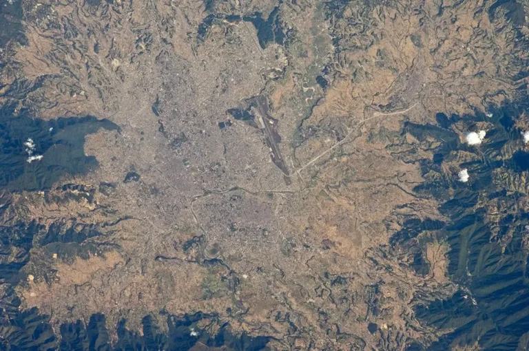
Nepal is often pictured through its highest mountains, but that view misses the plains where much of its population lives and the valleys where major cities developed. Reading the country from south to north reveals a different story: lowland farms, densely settled basins, steep hills and some of Earth’s highest summits occupy a remarkably short horizontal distance.
Nepal is a landlocked country in South Asia between India and China, with Kathmandu as its capital. Its geography rises from the southern Terai plains through middle hills and valleys to the Himalayas. Elevation, summer monsoon rainfall and river corridors help explain its contrasting climates, farming landscapes and settlement patterns.
How to use this article: Compare the main landscapes, follow water from mountains to plains, or explore where people live.
1. Locate Nepal and read its map
Nepal extends along the southern side of the Himalayas. China lies to its north, while India borders it on the west, south and east. It has no coastline. Its rivers nevertheless connect it to the wider lowlands of South Asia, and roads and border crossings connect its economy with neighboring countries.
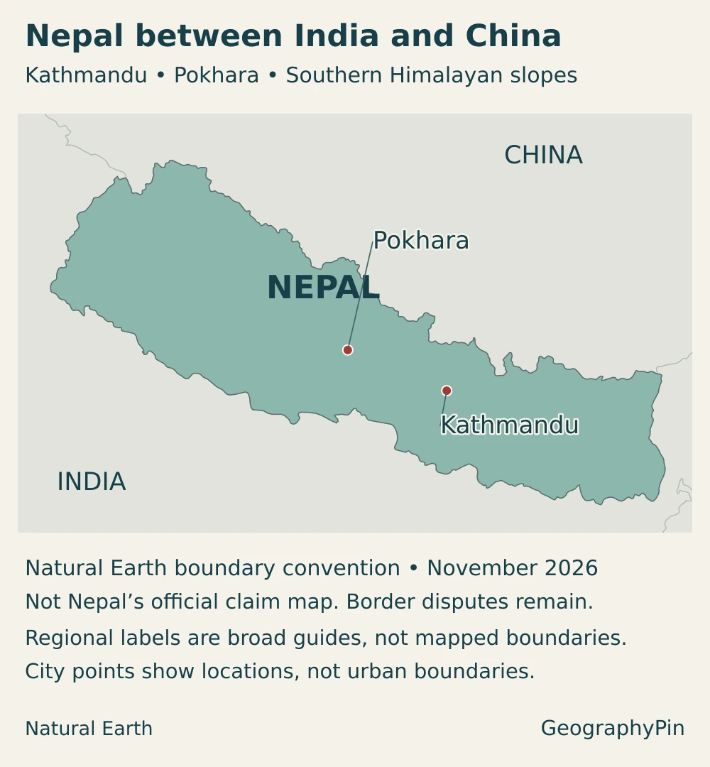
The country is elongated roughly east–west. The Nepal Tourism Board describes an east–west span of about 500 miles (800 km), compared with roughly 90–155 miles (150–250 km) north–south. Those approximate dimensions help explain why a short movement across the map can cross very different environments; they are not road distances.
For the wider regional setting, use the South Asia countries map. Nepal is an independent country, not a region of India or China. A generalized national outline is also not a legal settlement of every boundary disagreement: territorial claims and the map’s boundary convention are explained in the notes below.
2. Country facts with dates and definitions
| Item | Figure or description |
|---|---|
| Capital | Kathmandu |
| Population | 29,164,578 people in the 2021 National Population and Housing Census, with census day November 25, 2021 |
| Officially reported country area | About 56,956 square miles (147,516 km²), the figure published by Nepal’s government; territorial scope requires the qualification below |
| Official language at federal level | Nepali in the Devanagari script; constitutional recognition extends to other mother tongues, and provinces may adopt additional official languages |
| Currency | Nepalese rupee (NPR) |
| Constitutional system | Federal democratic republic |
| Government structure | Federal, provincial and local levels; seven provinces |
| Highest summit | Mount Everest, or Sagarmatha: about 29,032 feet (8,848.86 m), the snow-surface height jointly announced by Nepal and China in December 2020 |
The population is a dated census count, not a live population estimate for the current year. Similarly, the country-area figure is not an independently calculated dry-land total. Nepal’s official territorial accounting and generalized international mapping datasets can differ, particularly around contested boundaries; dividing population by an area with different coverage can create misleading precision.
3. From the Terai to the high Himalayas
Three broad regions, with important differences inside them
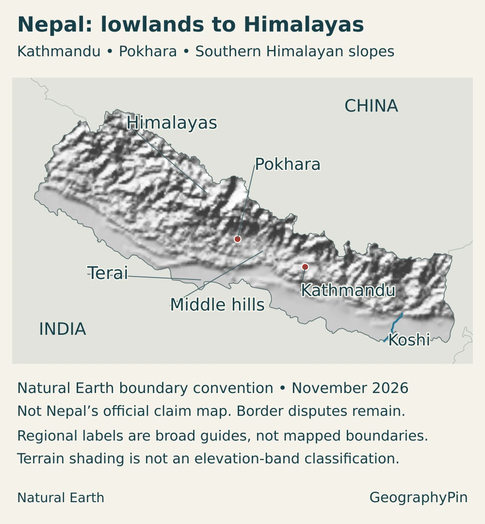
The Terai, middle hills and high Himalayas are a useful first reading of Nepal, not three perfectly level steps. The hill belt contains deep valleys and ridges, the mountains contain sheltered basins, and foothill ranges interrupt the transition from the southern plains. More detailed classifications separate the Siwalik or Chure foothills, middle mountains, high mountains and high Himalayas.
| Landscape | Where to look | Geographic significance |
|---|---|---|
| Terai plains | Southern lowlands along India | Warm, relatively low-relief country with extensive cultivation, towns and major river floodplains |
| Siwalik or Chure foothills | Between the plains and higher hills, with intervening valleys | A transition of ridges and valleys, not a single continuous flat terrace |
| Middle hills and basins | Interior hill country, including Kathmandu and Pokhara valleys | Contrasting slopes and valley floors support different settlement and farming patterns |
| High mountains and Himalayas | Northern mountain belt | Very high relief, alpine environments and glacier-covered areas; sheltered valleys can be much drier than exposed slopes |
These are landscape descriptions rather than provincial borders. A province can extend across several elevation belts. Nor does the word “hill” mean gentle terrain: steep slopes and substantial local relief can occur well below the highest Himalayan peaks.
Why the relief is so dramatic
The Himalayas belong to the collision zone between the Indian and Eurasian continental plates. Compression and the underthrusting of India beneath Eurasia are associated with mountain building and earthquake activity. Nepal’s topography is therefore part of a much larger mountain system, not an isolated chain confined to its borders.
Everest stands on the Nepal–China boundary. Its announced height refers to the summit’s snow surface above sea level, not a measurement from the mountain’s visible base. The surrounding Himalayan landscape includes many ridges, valleys and summits at different elevations; a summit height says little about the conditions in a nearby inhabited valley.
The major mountain ranges world map places the Himalayas alongside other mountain systems. Within Nepal, the more useful everyday distinction is often between an accessible valley floor and the steep slopes or high passes around it.
4. Climate, rivers and environmental contrasts
Elevation and exposure matter more than one national average
Nepal’s lowlands can be hot while its highest terrain remains cold and icy. Temperatures generally decrease with elevation, but the difference between locations also depends on season, slope exposure and local conditions. Kathmandu’s weather cannot represent the Terai, and neither provides a useful forecast for a Himalayan pass.
The summer monsoon supplies most of Nepal’s annual rainfall, usually concentrated from June to September. Mountains force moist air upward, helping create wet slopes, while sheltered areas such as parts of Mustang and Manang lie in rain shadows. The contrast is not simply “higher means wetter”: the mountain barrier can produce dry conditions on its sheltered side.
Rivers connect environments that look separate on a map
Major river systems include the Mahakali, Karnali, Gandaki or Narayani, and Koshi or Saptakoshi. These connect with the wider Ganges drainage system beyond Nepal. They are not Nepal’s only rivers: smaller systems, including the Bagmati, also link inhabited valleys and hills with downstream lowlands.
The Koshi system is a clear example of those connections. Its basin crosses China, Nepal and India, linking high mountain catchments with eastern Nepal’s hills and southern lowlands. A basin is the land draining toward a river system, not just the blue line of its main channel. Tributaries and upstream conditions matter to communities far downstream.
Water availability also changes through the year. The same river basin can experience damaging floods during wet periods and shortages in drier periods. Irrigation, drinking-water supply and hydropower therefore depend on the timing and reliability of flow, not only on whether a river is large on a national map.
Different hazards require different explanations
Heavy rainfall can affect slopes, roads and lowland floodplains, while earthquakes arise from tectonic processes. At high elevations, a glacial lake can release water rapidly if its containing dam fails or is overtopped. Rock or ice entering a lake can generate a wave that contributes to such a failure; glacier retreat does not mean every nearby lake is about to burst.
These risks are connected to terrain and exposure. A flood can threaten downstream infrastructure far from its mountain source, while a steep slope may be vulnerable to failure without being near a glacier. A country-scale relief map helps explain the setting but does not substitute for local hazard assessments or current warnings.
5. People, cities and languages
The plains and valleys are central to Nepal’s population
The 2021 census recorded 53.61% of Nepal’s population in the Terai ecological belt. That is an important correction to the image of a country populated mainly in remote high mountains. The statistic uses the census’s ecological classification; it is not a claim that the same share lives inside a narrow elevation contour or one province.
Kathmandu is the national capital within the Kathmandu Valley. The city, its municipality and the wider valley are different geographic units, so population figures for one should not be substituted for another. The valley contains several historic urban centers, including Kathmandu, Patan and Bhaktapur, and its cultural landscape includes Hindu and Buddhist monument complexes.
Pokhara is another important valley city, west of Kathmandu and closely connected with the Annapurna region. Its lakes, mountain setting and role as a base for travel into the surrounding hills make it a useful example of how urban services and tourism connect with physical geography. The capital’s detailed urban story belongs in the separate Kathmandu profile.
One official federal language does not mean one culture
The constitution makes Nepali in the Devanagari script the official language of Nepal. It also recognizes all mother tongues spoken in Nepal as languages of the nation and allows provinces to designate additional official languages under the constitutional framework.
Language, ethnicity, religion and region describe different aspects of identity. A map of provinces cannot by itself show the distribution of every language community, and a national language designation does not imply that all households use the same first language.
6. Government and economy in their geographic setting
Nepal’s federal constitution provides for national, provincial and local government. These administrative levels organize public responsibilities, while the Terai, hill and mountain belts describe physical or statistical geography. They should not be treated as interchangeable divisions of the country.
The economy reflects both the opportunities and constraints of this setting. Agriculture depends on suitable land and dependable water; steep terrain and seasonal hazards complicate transport and service delivery. Hydropower offers a way to use river flows for electricity, but successful projects also require transmission connections, reliable operation and attention to environmental and downstream effects.
Tourism links Nepal’s mountains, valleys and cultural heritage with international visitors. Pokhara’s connections to the Annapurna region and the historic centers of Kathmandu Valley illustrate different parts of that economy. Tourism is not the whole national livelihood picture: services, farming, trade and work abroad also matter.
Remittances connect households in Nepal with earnings made overseas. Nepal Rastra Bank’s annual macroeconomic reporting treats these inflows separately from export earnings and other external transactions. They are money transferred home, not a measure of tourism receipts or the value of goods produced inside Nepal.
For a landlocked country, dependable connections across borders are particularly important. At the same time, the World Bank’s climate and development assessment emphasizes resilient roads, water management and urban systems. The central geographic challenge is not simply building more connections, but keeping settlements and economic activities connected through difficult terrain and changing seasonal conditions.
Frequently Asked Questions
Is Nepal entirely mountainous?
No. Nepal includes the southern Terai plains as well as hills, valleys and high Himalayan terrain. Its dramatic north–south elevation contrast is one reason climate and settlement vary so much within the country.
Is Mount Everest entirely inside Nepal?
No. The summit lies on the boundary between Nepal and China. The two countries jointly announced its snow-surface height of about 29,032 feet (8,848.86 m) in December 2020.
What Did We Learn Today?
Nepal is best understood as a country of connected elevation belts, not simply a collection of Himalayan summits. The Terai plains, interior hills and valleys, and high mountains shape climate and settlement, while rivers connect their opportunities and risks. Kathmandu’s capital role, a diverse language landscape and a federal government structure add human geography to that physical framework.
Sources & Data Notes
- National Statistics Office, 2021 census: Population and ecological-belt classification; census figures are not current-year estimates.
- Nepal Law Commission, Constitution: Capital, federal structure and language provisions.
- Nepal Tourism Board, geography: Location, approximate dimensions, reported area and broad regions. Its older Everest height is not used.
- National Statistics Office, Environment Statistics of Nepal 2024: More detailed physiographic classes, table 2.2.1. Older summit-height and climate-table entries are not used as current measurements.
- Joint Nepal–China Everest height announcement, December 2020: Snow-surface height and boundary setting.
- USGS, Himalaya tectonic setting: Continental collision and earthquake processes.
- Nepal Tourism Board, climate: Seasonality, elevation contrasts and rain-shadow settings, not a weather forecast.
- Government of Nepal, National Water Plan (2005), hosted by UN ESCAP: Sections 1.4 and 4.2.3.2 identify river systems and their drainage connections; historical economic figures and policy targets are not used as current data.
- ICIMOD, Koshi basin: Transboundary river geography and seasonal water-management challenges.
- ICIMOD, glacial lake outburst floods: Flood mechanisms, not a prediction for any individual lake.
- UNESCO, Kathmandu Valley: Historic urban centers and cultural landscape.
- Nepal Tourism Board, Pokhara: Valley and Annapurna tourism connections.
- World Bank, Nepal climate and development report: Geographic constraints, water, energy and resilient development; recommendations are not measured future outcomes.
- Nepal Rastra Bank, annual macroeconomic report for FY 2025/26: Currency context and remittances as a distinct external-account category.
Maps and territorial scope: Original GeographyPin maps use public-domain Natural Earth country, city and river data, with its georeferenced shaded-relief raster. They use a Lambert azimuthal equal-area projection centered on Nepal. Landscape labels are broad guides, not surveyed regional boundaries; terrain shading is not an elevation classification. The blue river line shows only a lower Sapta Koshi segment, not its entire basin or all tributaries.
Boundaries follow Natural Earth’s generalized de facto convention, not Nepal’s official claim map. Nepal and India have unresolved boundary disagreements, including the Kalapani–Lipulekh–Limpiyadhura area in the northwest and Susta. Nepal’s 2019–2020 foreign-affairs report describes its position and revised map. The official country-area figure and this generalized mapped outline therefore should not be treated as identical territorial measurements. No disputed-area extent is invented, and these illustrations do not settle sovereignty.
The cover preserves Nepal’s double-pennant flag intact and proportionate within a crimson country silhouette. It uses the public-domain flag vector drawn by Pumbaa80 and Achim1999, rather than stretching the flag into a rectangle. All three illustrations are original GeographyPin compositions; they are not official government maps.