The Maldives is a South Asian island country in the Indian Ocean, southwest of India and Sri Lanka. Its low-lying coral islands belong to a much larger reef-and-atoll landscape that crosses the equator. Malé is the capital. Natural atolls, inhabited islands and administrative units are different things, so their counts should not be used interchangeably.
A resort photograph shows only one part of Maldivian geography. The more useful picture includes reef platforms, channels, lagoons, densely settled urban islands and wetlands. These landscapes explain both the country’s economic opportunities and its difficulties with transport, freshwater and coastal exposure.
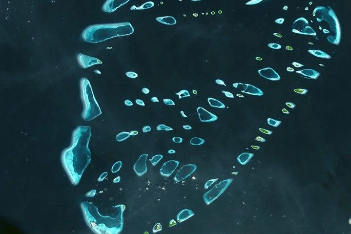
Use the locator to place Malé, Fuvahmulah and Addu, then use the satellite image of Malosmadulu to see how reefs and islands fit together. The key distinction is between the land above water and the wider marine structures that support it.
1. Where are the Maldives?
The Maldives lies in the Indian Ocean, southwest of the Indian peninsula and Sri Lanka. It is an independent country, not a province of either neighbor. Most of its island chain lies north of the equator, but the southern end extends into the Southern Hemisphere. Fuvahmulah and Addu are useful southern reference points; Malé lies farther north.
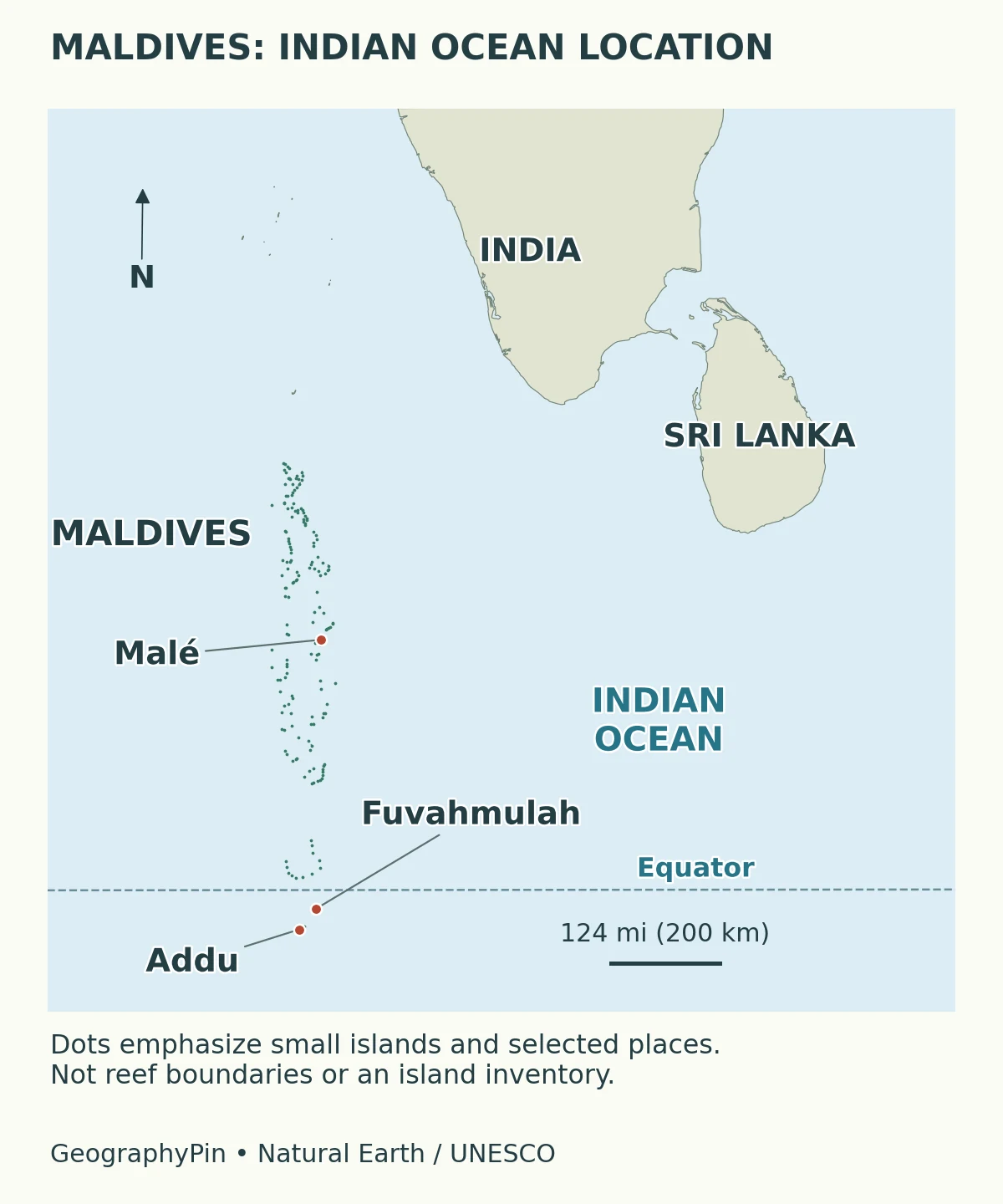
At this scale, the country is easy to overlook because individual islands are tiny beside the Indian mainland. That does not make the surrounding water empty space. It contains reef systems, routes between settlements and the fishing grounds on which island communities depend. A land-only outline therefore gives an incomplete impression of how the country functions.
The map is a locator, not a navigation chart. It does not show navigable reef passages, reef depths, administrative boundaries or the latest reclamation works. Those require more detailed, purpose-built information.
2. Key facts and population
| Fact | Answer | Important qualification |
|---|---|---|
| Capital | Malé | The capital island and the wider statistical urban area are not identical |
| National language | Dhivehi, written in Thaana | English is also widely used as a secondary language |
| Currency | Maldivian rufiyaa (MVR) | National currency, not a hotel-price quotation |
| Resident census population | 515,132 | Final 2022 census: 382,639 Maldivian residents and 132,493 foreign residents |
| Later population projection | 581,053 | 2025 projection reported in the Maldives Bureau of Statistics’ 2026 Pocketbook; not a new census |
| Island inventory | 1,556 islands | Count published in the 2026 Pocketbook; the page does not establish a precise survey date or counting method |
Older descriptions often give about 1,190 or 1,192 islands. They should not be silently combined with the newer inventory, and subtracting the two does not establish how many islands were created by reclamation. For a general description, more than 1,000 low-lying coral islands avoids pretending that all sources use one timeless inventory.
A census counts residents under a stated definition; a projection estimates a population for another reference period. Registration is a third concept: being registered to an island is not necessarily the same as living there. Mixing these series can produce an apparent population change that is really a change in what is being counted.
The same caution applies to area. Dry land, lagoons, territorial waters and an exclusive economic zone are not interchangeable measurements. An ocean-space figure cannot be used as though it were the land area beneath the country’s houses and roads.
3. How islands, reefs and atolls fit together
An island is land above the water. A reef is a marine structure, much of which may remain submerged. An atoll is a broader reef-and-lagoon arrangement, not simply another word for one island. In the Maldives, a reef platform can support several small islands, while other reef features have no permanently exposed island on them.
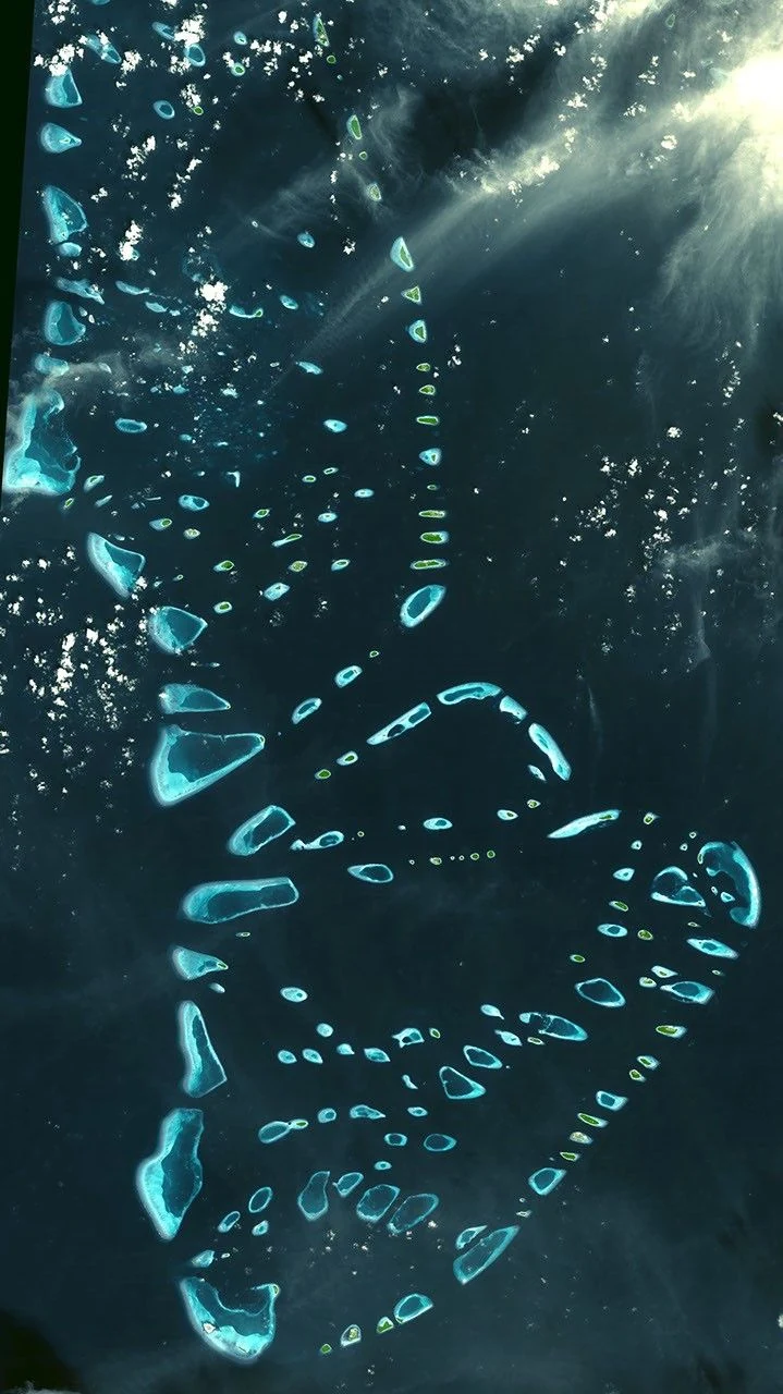
Reef organisms supply carbonate material, and waves and currents redistribute sediment into island landforms. Lagoons can contain patch reefs and smaller reef structures; openings connect the interior waters with the ocean. The resulting geography is irregular, not a collection of identical circles.
The familiar classroom explanation of an atoll growing around a sinking volcanic island is a useful starting model, but it does not explain every detail of modern Maldivian atolls. A 2021 review by André Droxler and Stéphan Jorry emphasizes older carbonate banks, repeated sea-level fluctuations, dissolution during periods of exposure and renewed reef growth. The volcanic foundation and the shape of today’s reef rim are different stages of a much longer history.
There is also a difference between the age of that geological foundation, the development of a reef system and the accumulation of an island’s sand. A single age assigned to “the Maldives” can conceal those very different processes.
4. Natural atolls versus administrative units
Physical geography and government administration answer different questions. Natural-atoll descriptions group reef structures; administrative names identify areas used for services, records or governance. An administrative label therefore cannot automatically be read as the boundary of one geological atoll.
The Maldives is commonly described as having 26 natural atolls, including in the Maldivian mission’s geographic overview. Other official background material uses different geographic groupings. Treat 26 as a conventional description, not as a universal classification rule that every map must reproduce.
Older references also describe 20 administrative atolls. That does not justify calling them 20 current atoll councils. The Presidency announced that all atoll councils and their secretariats were abolished effective May 17, 2026. In October 2026 it announced 18 Government Services Centres. Those centres are not a revised count of natural atolls, and the institutional change does not mean reef systems disappeared.
When comparing maps, check whether a name refers to a reef group, an administrative area, an island or a city. When comparing statistics, retain the boundaries and reference year used by the original publication. Otherwise two correct figures can appear to contradict each other simply because they describe different units.
5. Three places that explain the country
Malé: the capital is not the whole urban area
Malé shows how intensely settled an island environment can become. However, a population published for the wider Malé statistical area should not be divided by the area of the original capital island. Census coverage includes associated places such as Hulhumalé and Villimalé. The numerator and denominator must describe the same territory before a density calculation means anything.
For its national role, Malé belongs in our world capital cities reference. For its urban geography, the more revealing question is how housing, transport and services connect across separate islands.
Fuvahmulah: not every island encloses a lagoon
South of the equator, Fuvahmulah provides a clear counterexample to the idea that every Maldivian island sits inside a ring-shaped lagoon. UNESCO describes its single-island setting and shallow bowl-shaped surface. Bandara Kilhi and Dhandi Magu Kilhi occupy low areas surrounded by wetlands. There is no lagoon between the outer reef edge and the island’s beaches, leaving the shore exposed to ocean waves.
Addu: reefs and wetlands together
Addu is the southernmost atoll and another UNESCO biosphere reserve. Its environments include coral reefs, mangroves, freshwater ponds and brackish lakes. These wetland habitats matter because a postcard view of white sand and open sea leaves them out. They also show why the blanket statement “the Maldives has no lakes” is too crude.
6. Climate, elevation and freshwater
The Maldives has a warm, humid monsoon climate. Winds reverse seasonally, with a generally wetter southwest-monsoon period and a drier northeast-monsoon period. The timing and rainfall pattern vary along the island chain; southern locations do not follow every northern seasonal pattern exactly. A season label is therefore a broad climatic guide, not a promise of rain-free weather on a particular island.
Low elevation is a fundamental constraint, but a single national height number is not a map of flood risk. Shoreline position, waves, reef condition, drainage and coastal structures all affect exposure. Natural island surfaces and engineered reclaimed land should not be treated as if they have identical elevations or histories.
The government’s 2025 climate submission identifies limited groundwater and rainwater resources, with freshwater lenses vulnerable to saltwater intrusion, contamination and over-extraction. Desalination and rainwater harvesting are important parts of water provision. The practical question is not only whether land remains above sea level, but whether settlements retain reliable drinking water and functioning infrastructure.
Island shorelines can change as sediment moves, while reclamation and coastal engineering also alter the coastline. Neither change automatically proves safety or inevitable loss. An island maintaining its area can still face flooding, freshwater stress or ecological damage. Likewise, one eroding beach does not establish the future of every island in the country.
That is why an exact “disappearance year” is not a sound summary of Maldivian geography. Sea-level change and coastal adaptation require location-specific evidence rather than a countdown attached to the entire archipelago.
7. People, transport and the marine economy
Dhivehi, written in the Thaana script, is the national language. English also has an important secondary role. The country is a republic; its national identity is not defined by the resort industry alone. The distinction between Maldivian citizens, foreign residents and temporary visitors is particularly important when reading population and tourism figures.
Tourism and fisheries connect the economy directly to the sea. The government’s climate submission identifies tourism as its largest economic sector and highlights fisheries, especially tuna fishing, as a major livelihood. Reef condition, coastal access and dependable water and energy supplies are therefore economic concerns as well as environmental ones.
Transport must connect land separated by water rather than serve one continuous mainland. The geography makes a national map of settlements different from a simple road map. Malé’s urban concentration, the scattered island communities and the southern examples of Fuvahmulah and Addu together give a fuller picture than any single resort island can provide.
What Did We Learn Today?
The Maldives is best understood as an island-and-reef country, not just a collection of beaches. Islands, natural atolls and administrative units describe different things. Malé, Fuvahmulah and Addu reveal contrasting urban, reef and wetland settings, while dated population figures prevent census counts from being confused with projections. Low elevation matters, but water security, reef health and local coastal conditions make the country’s challenges more complex than a single height or disappearance date.
Sources & Data Notes
- Maldives Bureau of Statistics: Pocketbook 2026 and 2022 census definitions. Census totals, the separately identified 2025 projection, island inventory and geographic scope. Publication year is not an island-survey date.
- Presidency, May 18, 2026 and October 8, 2026. Abolition of atoll councils and establishment of Government Services Centres, respectively.
- Maldivian mission: geography. Conventional 26-atoll description; older island and tourism counts are not used as current statistics.
- Abdulla Naseer: Maldivian marine habitats. Reef structures and sediment processes; its historical demographic figures are not current data.
- Droxler and Jorry, 2021, The Origin of Modern Atolls. Published review abstract for the distinction between older foundations and modern atoll development.
- UNESCO: Fuvahmulah and Addu Atoll. Landscape and wetland examples; undated population fields are not used.
- Foundation for Environment, Climate and Technology: Maldives climatology. Seasonal and north–south differences, not a trip-specific forecast.
- Maldives Third Nationally Determined Contribution, 2025. Freshwater vulnerabilities and tourism/fisheries context.
- U.S. International Trade Administration: Maldives and WIPO Lex: 2008 Constitution. Language, currency and constitutional background; current administrative changes are sourced separately above.
Map and image notes: GeographyPin’s locator uses public-domain Natural Earth outlines and Malé point data, with UNESCO reference coordinates for the two southern reserves. Tiny island symbols are emphasized; no reef boundaries or modern island inventory are inferred. The ASTER scene and its cropped featured image date to December 22, 2002. Credit: NASA/GSFC/METI/ERSDAC/JAROS, and U.S./Japan ASTER Science Team; reused under NASA Earth imagery guidance, with resizing/cropping and format conversion only.