Bangladesh’s geography is shaped by rivers arriving from a much larger upstream region, spreading across lowlands and meeting the Bay of Bengal. Yet the country is not one uniform floodplain: older terraces, northeastern wetlands and southeastern hills give it important internal contrasts.
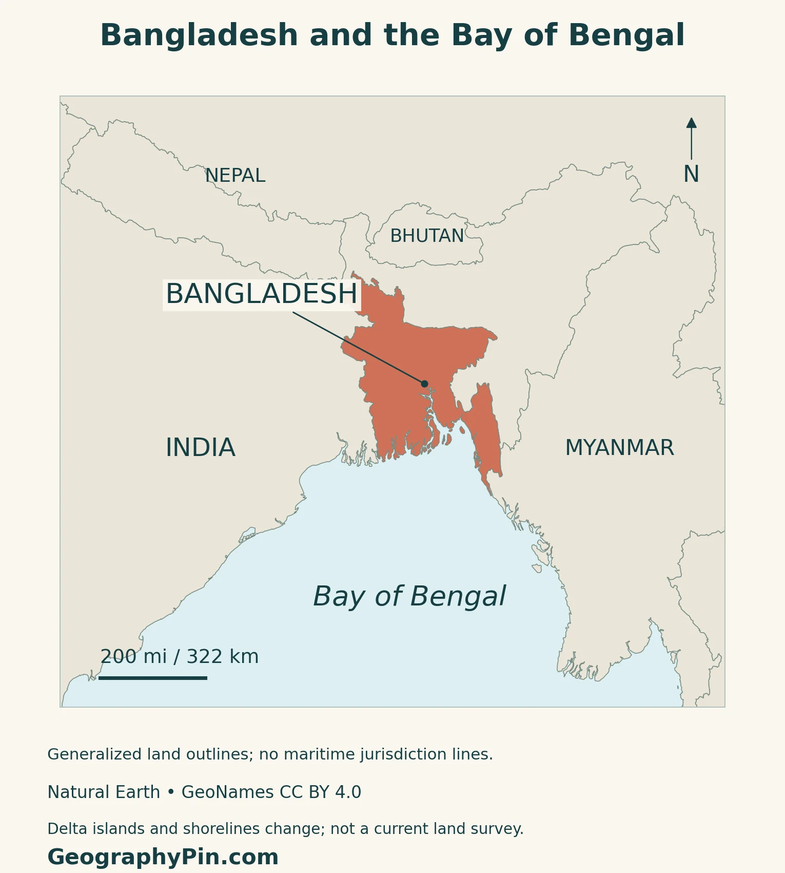
Bangladesh lies in South Asia, bordered mainly by India, with Myanmar to the southeast and the Bay of Bengal to the south. Much of its landscape belongs to the Ganges–Brahmaputra–Meghna delta and floodplain system. Water and sediment support farming, fisheries and settlement, while monsoon floods, shifting riverbanks and coastal surges create different kinds of exposure.
How to use this article: Follow local river names, compare physical regions, compare flood processes, or check the census adjustment.
1. Locate Bangladesh and Follow Its Rivers
A downstream country at the head of the Bay of Bengal
India borders Bangladesh on the west, north and much of the east. The shorter Myanmar frontier lies in the southeast. Dhaka, the capital, is inland among a network of rivers; Chattogram is farther southeast near the coast.
The national boundary does not enclose the whole drainage system. Water reaching Bangladesh has traveled through upstream catchments beyond the country. A locator map therefore provides one frame, while the connected river basin provides another.
Jamuna, Padma and Meghna name particular reaches
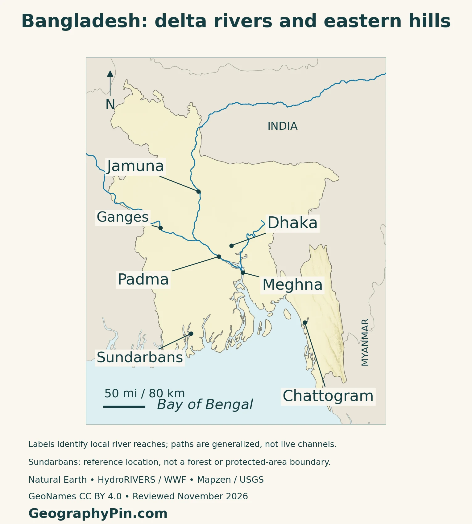
The Brahmaputra’s main channel in Bangladesh is called the Jamuna. It meets the Ganges near Goalanda. In the technical naming used here, the combined reach downstream is the Padma; it then meets the Upper Meghna near Chandpur, and the Lower Meghna carries the combined flow toward the bay.
“Padma” is also used more broadly for the Ganges within Bangladesh. The map places each local label on its intended reach rather than renaming an entire transboundary river line.
2. Floodplains, Terraces, Hills and Tidal Forest
Low relief does not mean identical terrain everywhere
The main physical divisions are floodplains, older terrace surfaces and hills. Barind and Madhupur are notable terrace areas; the Chattogram Hill Tracts form a contrasting southeastern landscape. Hills also occur along parts of the northeastern margin.
| Setting | Physical character | Why it matters |
|---|---|---|
| River floodplains | Low terrain with channels, ridges and depressions | Flood depth and drainage vary over short distances |
| Barind and Madhupur terraces | Older, relatively elevated surfaces | Different from recently deposited active floodplains |
| Northeastern haor basins | Seasonally inundated depressions | Wet-season open water contrasts with dry-season pools and land |
| Southeastern hills | Ridges, slopes and valleys | Not part of a uniformly flat delta surface |
| Sundarbans tidal coast | Mangroves, mudflats and branching waterways | Freshwater and tidal processes interact |
A haor changes character with the season
FAO’s study of Hail Haor in northeastern Bangladesh describes a basin that expands into a broad lake during the rainy season. As water falls, channels and smaller water bodies remain among exposed land. Fish movement and fishing opportunities change with that cycle.
A wet-season image and a dry-season image can therefore show very different amounts of open water without either being an incorrect map. For local planning, the timing of the observation matters as much as its outline.
The Sundarbans is a tidal forest, not the whole delta
The Sundarbans mangrove landscape extends across southwestern Bangladesh and neighboring India. UNESCO describes Bangladesh’s listed property as a network of tidal channels, mudflats and small islands with salt-tolerant forest. India has a separately listed Sundarbans property.
The forest is one part of the wider delta, not a name for every cultivated or urban lowland. Its tidal waterways also differ from the main freshwater river channels farther inland.
3. Monsoon Water, Flooding and Riverbank Change
Wet and dry seasons create different water problems
The broad climate cycle includes a hot pre-monsoon period, a rainy summer monsoon, a post-monsoon transition and a cooler, drier winter. June through September is commonly used for the monsoon season, although actual onset and withdrawal vary.
Bangladesh’s land-and-water planning must address both excess water in the rainy season and freshwater shortages in the drier part of the year. Heavy rainfall inside the country combines with upstream inflows; it is not the only source of river water.
Flood exposure is not the same in every landscape
Flooding is not one uniform process. Large rivers can spread across their floodplains, intense rain can produce rapid flooding near hilly catchments, and coastal communities face tides and cyclone-driven storm surges. Local drainage, elevation and protective structures influence which places are affected.
For example, the UN’s July 2026 reporting linked heavy monsoon rainfall with flash floods and landslides in affected districts, including the southeast.
Riverbank erosion is different from temporary inundation
NASA’s 2018 Padma image sequence documents changes in the river’s shape, width and position from 1988 onward. Banks retreat in some places while sediment builds new surfaces elsewhere. A settlement can face erosion of the ground beneath it as well as water temporarily covering the land.
The maps show generalized river paths, not a survey of today’s banks or sandbars. Channel change is especially important when comparing images from different dates.
4. Dense Settlement and Working with Water
Productive lowlands also concentrate exposure
Water supports livelihoods as well as hazards. FAO’s floodplain fisheries work explains how seasonal inundation connects feeding and spawning areas, while dry-season channels and pools provide refuges. Floodplain agriculture also requires managing the timing and availability of water.
These resources help explain the long importance of the lowlands, but soil fertility alone is not a complete explanation of today’s population density. Urban jobs, infrastructure and the concentration of people around existing settlements also shape the pattern.
Dhaka’s expansion changes the surrounding plain
ESA’s comparison of February 2017 and February 2026 Sentinel-2 images shows built-up growth around Dhaka into areas formerly occupied by agriculture and wetlands. The city sits within a complex river network, including the Buriganga and other channels, rather than directly on one simple riverbank.
NASA’s separate 2022 assessment used satellite observations to examine growing human presence near rivers. It illustrates how settlement expansion can increase exposure even without treating every nearby home as equally vulnerable.
Chattogram links manufacturing with maritime access
Chattogram adds a coastal industrial and transport role to the country’s settlement pattern. The Bangladesh Export Processing Zones Authority identifies Karnaphuli EPZ in North Patenga near the port and airport. Its listed industries include garments, leather goods, bicycles and furniture.
This is a different geographic connection from the capital’s administrative concentration: access to maritime transport helps locate export-oriented industry near the coast.
Embankments work together with drainage
Bangladesh’s coastal polders are low-lying areas protected by embankments and managed water-control systems. The World Bank’s Coastal Embankment Improvement Project describes work intended to reduce tidal flooding, storm-surge exposure and saline-water intrusion while supporting agriculture.
Protection is not simply a higher barrier. Drainage channels and control structures matter because water must also leave the protected land. Such infrastructure changes local conditions, so a national elevation map alone cannot determine the safety of a particular settlement.
5. Country Facts and the 2022 Census
Bangladesh: dated facts and national reference
| Item | Reference |
|---|---|
| Capital | Dhaka |
| Population | 169,828,911: 2022 census total adjusted after the post-enumeration check |
| National census area | About 56,977 square miles (147,570 square kilometers), as used by BBS in the 2022 census report |
| State language | Bangla (Bengali) |
| Currency | Bangladeshi taka (BDT); 100 poisha per taka |
| Government | Unitary parliamentary republic |
| Administrative structure | Eight divisions and 64 districts |
An adjusted census total is not a current estimate
The 2022 census recorded 165,158,616 people before adjustment. The Bangladesh Bureau of Statistics published an adjusted total of 169,828,911 after the post-enumeration check. These are two versions of the same census reference population, not a measure of growth between two years.
The area shown is the national area used in that report, not a dry-land-only figure.
For regional context, use the South Asia countries map and the Asia countries and capitals list.
What Did We Learn Today?
Bangladesh’s river-fed lowlands support dense settlement, agriculture and fisheries, while terraces, hills and tidal forest create distinct local environments. Jamuna, Padma and Meghna labels need to follow the correct river reaches. Monsoon flooding, bank erosion and coastal surges are related but different processes, and population figures need a date and a clear distinction between the census count and its adjusted total.
Sources & Data Notes
Population and national area follow the BBS 2022 census report, published in 2023, not a 2026 population estimate. Government-hosted report files were unavailable during review; the relevant table was inspected in a readable reproduction and exact totals corroborated against indexed official report extracts. The reproduction is linked separately and is not official hosting. Older geographical and satellite sources support landscape processes, not current riverbank surveys, weather forecasts or present-day economic totals. Current parliamentary structure and administrative units were checked in November 2026.
- Banglapedia: physical regions only; historical demographic and administrative figures not used
- Banglapedia: Jamuna, Padma and Meghna confluences; old numerical and administrative details not used
- ESA: delta and upstream river setting in 2003 imagery
- FAO (2002), Bangladesh country chapter, printed page 139: landforms, seasons and water management; old statistics not used
- FAO: floodplain fisheries and seasonal Hail Haor water patterns
- UNESCO: Bangladesh Sundarbans property and its tidal mangrove setting
- UN Bangladesh, 23 July 2026: dated flash-flood and landslide example, not a forecast
- NASA (2018): Padma channel change in the 1988–2018 image sequence
- ESA (2026): Dhaka land-cover comparison, February 2017 and February 2026
- NASA (2022): settlement expansion near rivers; historical population totals not used
- BEPZA: Karnaphuli EPZ location and industry types; undated employment/export totals not used
- World Bank (2022): coastal polders, embankments and drainage works
- BBS: 2022 Population and Housing Census, National Report Volume I, Table 3.1.3; official host unavailable, indexed totals corroborated
- Readable third-party reproduction of the BBS report used to inspect the census table; not official hosting
- Bangladesh Constitution, Part I: unitary republic, state language and capital
- IPU Parline: parliamentary structure and 2026 elected-parliament record
- Bangladesh National Portal: eight divisions and 64 districts, checked November 2026
- Bangladesh Coinage Order, Article 9: taka and poisha
Map method: Original GeographyPin maps use public-domain Natural Earth v5.1.1 country geometry, actual Mapzen/USGS elevation data, and GeoNames reference points under CC BY 4.0. The Sundarbans point is not a forest boundary. Major river paths use the licensed HydroRIVERS v1 network, with labels anchored to their local reaches. This generalized modeled network is not a survey of current banks or every braided channel; no connector is invented through the open Meghna estuary. Source selection favors major channels, not a claim that smaller rivers are absent. Shorelines and delta islands are generalized. The feature is a decorative flag-filled country outline beside a complete national flag.
HydroRIVERS license notice: This product GeographyPin Bangladesh Physical Map incorporates data from the HydroSHEDS version 1 database which is © World Wildlife Fund, Inc. (2006-2022) and has been used herein under license. WWF has not evaluated the data as altered and incorporated within GeographyPin Bangladesh Physical Map, and therefore gives no warranty regarding its accuracy, completeness, currency or suitability for any particular purpose. Portions of the HydroSHEDS v1 database incorporate data which are the intellectual property rights of © USGS (2006-2008), NASA (2000-2005), ESRI (1992-1998), CIAT (2004-2006), UNEP-WCMC (1993), WWF (2004), Commonwealth of Australia (2007), and Her Royal Majesty and the British Crown and are used under license. The HydroSHEDS v1 database and more information are available at HydroSHEDS.
HydroRIVERS reference: Lehner and Grill (2013), Global river hydrography and network routing. HydroSHEDS license and technical documentation.