The Netherlands is a low-lying country whose European territory borders Germany, Belgium and the North Sea. Its geography combines river deltas, coastal dunes, reclaimed polders and higher eastern and southern landscapes. Holland means only two provinces; the country also includes three Caribbean islands and is one of four countries within the Kingdom of the Netherlands.
A Dutch map is easier to understand when you separate three questions: where the land lies, how water moves across it, and which territory a statistic describes. A field below the national height datum is not necessarily flooded. A river near Rotterdam may carry water from far beyond the Dutch border. And a figure for the European Netherlands is not automatically a total for the entire kingdom.
This profile focuses on the European landscape, while explaining the Caribbean and constitutional distinctions separately. Start with the locator, then compare the measured elevation map with the examples of Flevoland, the Veluwe and South Limburg.
1. Where is the Netherlands?
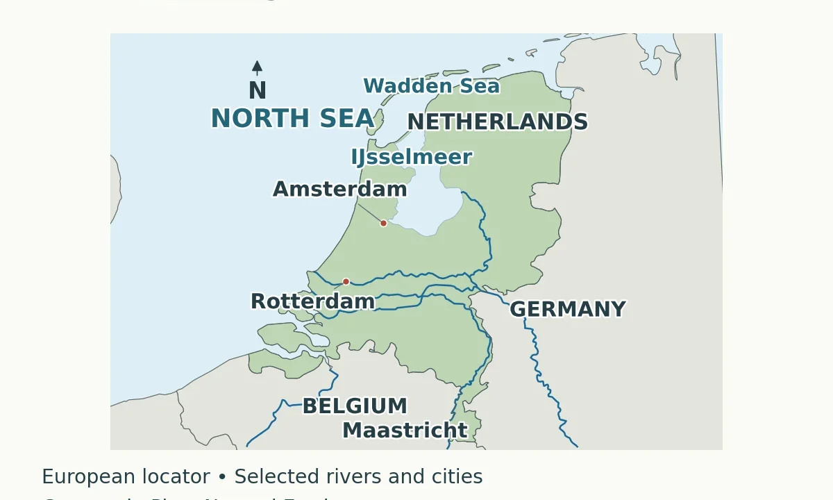
The European Netherlands occupies the North Sea side of northwestern Europe. Germany lies to its east and Belgium to its south. The coast faces the North Sea, while the Wadden Sea lies behind the northern barrier islands. Amsterdam is the capital; the national government and parliament are based in The Hague. Those are different roles, not competing answers to the same question.
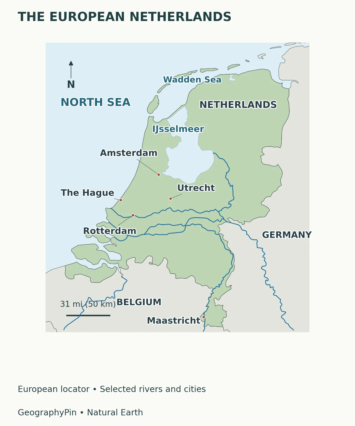
The city markers also explain why the western part of the country attracts so much attention: Amsterdam, The Hague, Rotterdam and Utrecht lie relatively close together. They are not the whole Netherlands, however. Maastricht, near the Belgian border, introduces a different southern landscape and a different relationship with the Meuse River. Our world capital cities reference distinguishes national capitals from other important cities.
2. Key facts, dates and territorial scope
Population figures change, while area totals depend on whether water is included and how it is classified. The table labels its sources and reference periods rather than treating every number as a live measurement.
| Fact | Figure or distinction | Scope and date |
|---|---|---|
| Capital and government | Amsterdam; government and parliament in The Hague | National roles, not municipal population rankings |
| Population | 18,130,208 | CBS population series, January 1, 2026; final figures released August 2026 |
| Area including water | About 16,040 square miles (41,543 square kilometers) | CBS ecosystem extent account, 2024 provisional figures; European provincial coverage |
| Provinces | 12 | European Netherlands; Caribbean public bodies are not additional provinces |
| Highest European point | About 1,058 feet (322.38 meters) above NAP, near Vaals | Rijkswaterstaat determination from late 2017; not the highest point of all Dutch Caribbean territory |
| Below the height datum | About 26% of Dutch land | PBL/Rijkswaterstaat assessment of land below NAP, not a 2026 resurvey or a kingdom-wide percentage |
The population value is a fixed January reference, not a claim about today’s exact headcount. CBS publishes Caribbean Netherlands population statistics separately. The area figure includes water, so it must not be used as though it were a dry-land total when calculating population density. Nor should changes between differently defined area tables be interpreted automatically as land gained from, or lost to, the sea.
3. Landscapes and elevation
“Low-lying” does not mean uniformly flat or entirely below sea level. Coastal dunes form elevated sandy ridges. Much of the western landscape includes low polders, while eastern areas contain higher sandy terrain. The Veluwe has wooded and heathland landscapes; South Limburg contains hills. These contrasts are more useful than imagining the whole country as one level surface.
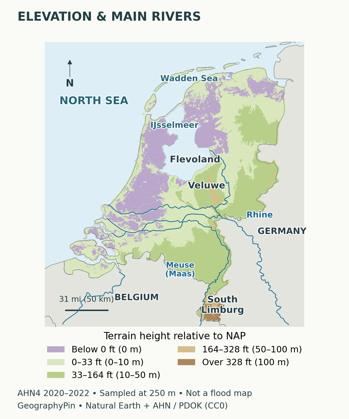
Three places that reveal the contrast
- Flevoland: reclaimed land in the former Zuiderzee/IJsselmeer landscape demonstrates how drainage and enclosure reshaped the national map.
- The Veluwe: higher ground in the central-eastern Netherlands breaks the stereotype of a country made entirely of polders.
- South Limburg: the southeastern hills, near Maastricht and Vaals, provide a clear contrast with the low western landscape.
NAP, or Normaal Amsterdams Peil, is the shared Dutch height reference. Rijkswaterstaat describes zero NAP as approximately mean North Sea level. It is a reference plane, not the water surface at every beach at every moment: tides, wind and river conditions still change actual water levels.
4. The delta and its river mouths
The Rhine reaches the Netherlands from Germany and branches into a connected lowland river system. Names such as Waal, Nederrijn, Lek and IJssel matter because the water does not follow a single straight line to one mouth. The IJssel carries water toward the IJsselmeer; other branches lead west through the delta toward the North Sea. The Meuse, called the Maas in Dutch, arrives from Belgium and forms another major artery.
This is both physical geography and managed infrastructure. Rijkswaterstaat’s water-distribution explanation shows how the Driel weir, Haringvliet sluices and Afsluitdijk outlets help regulate freshwater movement. In dry periods, decisions about river discharge also affect saltwater intrusion, farming and navigation. A blue line on a small-scale map therefore represents only part of a much more complicated operational system.
Why protecting land can mean giving water more room
Dikes are not the only response to high river levels. The completed Room for the River program widened flood pathways at selected locations rather than relying solely on higher embankments. This approach recognizes that rivers need space to carry large flows. It also explains why an area beside a river may have a different flood-management role from a protected urban neighborhood nearby.
The delta’s western outlets connect inland Europe with the sea. Rotterdam’s importance follows from that geography, but its port also depends on engineered waterways, terminals, railways and roads. “At a river mouth” is a starting point for explaining a port, not a complete explanation of its modern economy.
5. Polders, dikes and below-sea-level land
A polder is an enclosed area where water levels are controlled. It is not simply a synonym for land stolen from the sea. Some polders occupy former lakes; others developed through different histories of enclosure and drainage. Dikes help separate water systems, while channels, sluices and pumps manage the water inside them. Keeping water out and removing excess water are related but different jobs.
Beemster and Flevoland: two different reclamation stories
Beemster, north of Amsterdam, was a lake drained in 1612. Its planned pattern of roads, plots and watercourses remains central to its UNESCO World Heritage significance. The water authority explains that this was a deliberately designed landscape, not merely an empty basin that happened to dry out. Later pumping technologies replaced the original wind-powered drainage.
Flevoland belongs to the much later Zuiderzee Works. The Afsluitdijk, completed in 1932, separates the Wadden Sea from the IJsselmeer. Reclamation continued in stages: eastern Flevoland was drained in 1957 and southern Flevoland in 1968. The approximately 20-mile (32-kilometer) Afsluitdijk and the polders are connected parts of that history, but the dam itself is not the same thing as reclaimed farmland.
What the familiar 26% figure actually means
PBL’s assessment places about 26% of Dutch land below NAP. Its fuller explanation distinguishes that from the larger area susceptible to sea or river flooding and excludes open-water bodies from its land denominator. The figure does not mean 26% of the country is presently underwater, nor does it say every place below NAP has the same chance of flooding.
Elevation, exposure and protection are different variables. A low polder can be defended by engineered structures; land above NAP can still be exposed to river flooding. The terrain map above is useful for understanding elevation, but it cannot show defense condition, flood probability or safe evacuation routes. Those require dedicated assessments, not a simple color threshold.
6. Netherlands, Holland and the kingdom
Holland refers to North Holland and South Holland, two of the twelve European provinces. Using it for the whole country is common informally, but it leaves out places such as Zeeland, Friesland and Limburg. The word Dutch describes the country’s people and language; it is not the name of a separate territory.
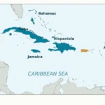
The Netherlands is one country within the Kingdom of the Netherlands. The other three constituent countries are Aruba, Curaçao and Sint Maarten. Bonaire, Sint Eustatius and Saba have a different status: they are public bodies within the Netherlands itself, collectively called the Caribbean Netherlands.
Consequently, “the Netherlands is in Europe” works as a short introduction to its European mainland but is incomplete as a constitutional description. Likewise, a European elevation map cannot establish the highest point of the entire country, including its Caribbean islands. Keep the territorial scope attached to the claim.
7. People, languages and the economy
The western cities perform different functions: Amsterdam is the capital, The Hague houses national government, and Rotterdam is a major maritime and inland transport center. Utrecht adds another major city to this western network. Their separate identities matter more than treating the whole urbanized west as one continuous city or confusing a city population with a provincial total.
Dutch is the official language nationally. Frisian also has official status in the province of Fryslân. The government recognizes additional regional and minority languages, and the Caribbean islands have their own language arrangements. That linguistic geography is another reason a description based only on Amsterdam cannot represent the whole country.
The economic landscape is broader than windmills, flowers and dairy farms. CBS’s account of 2023 value added shows that services supplied more than three-quarters of the economy. Manufacturing, trade, healthcare, finance and other activities belong in the picture alongside agriculture. This dated economic measure describes production, not the share of land covered by each activity.
Rotterdam provides a particularly clear example of geography meeting infrastructure. The port connects ocean shipping with inland waterways, rail and road transport. Its reach into the European interior depends on the Rhine system and on constructed connections, not just proximity to seawater. At the same time, low river levels can create navigation and freshwater problems, illustrating why water management supports economic life as well as flood protection.
For the national symbol rather than the landscape, see our flags of the world reference. The country profile and the flag guide answer different questions; neither should substitute for the other.
What Did We Learn Today?
The Netherlands combines a North Sea coast, a branching river delta, managed polders and higher eastern and southern landscapes. Its water geography is not captured by saying that it lies below sea level: elevation, flood exposure and engineered protection must be separated. Holland is only two provinces, while the Netherlands and its wider kingdom have distinct territorial meanings. Reading a Dutch map well means keeping those boundaries, water systems and statistical scopes in view together.
Sources & Data Notes
- Government of the Netherlands: constituent countries and Caribbean public bodies.
- UK PCGN: Netherlands toponymic factfile, for names and capital/government distinction.
- CBS population key figures: final January 1, 2026 reference, not a current live count. CBS ecosystem extent: 2024 provisional total including water; not a land-only area.
- PBL: correction and full land-surface distinctions. The 26% figure belongs to the historical PBL/Rijkswaterstaat assessment, not a new calculation from our illustration.
- Rijkswaterstaat: NAP, including the stated late-2017 determination near Vaals.
- Rijkswaterstaat: Room for the River; freshwater distribution; Zuiderzee Works; Afsluitdijk. Historical facts are separated from evolving project schedules.
- UNESCO: Beemster Polder; Hollands Noorderkwartier Water Authority: Beemster.
- Netherlands Board of Tourism: Holland and regional landscapes; Dutch government: recognized languages.
- CBS: economic structure in 2023; Port of Rotterdam: transport connections. No current cargo rankings or totals are inferred.
- Map method: original GeographyPin cartography using public-domain Natural Earth boundaries, cities, lakes and selected river lines. Elevation uses the official AHN4 terrain service via PDOK, licensed CC0. Its 2020–2022 surveys were sampled at 250-meter spacing using nearest-neighbor resampling and displayed in the Dutch RD New projection. Missing data remain unfilled. River lines are generalized and do not represent every channel, water-control structure or present operational flow. The maps cover European Netherlands, not the Caribbean, and are not navigation or flood-safety products.