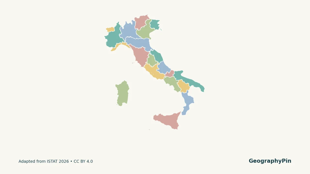
Florence is in Tuscany, Venice is in Veneto, and Rome is in Lazio. A regional map connects familiar city names to the larger administrative areas around them. Start with the numbered map, then use the matching capital table directly below it.
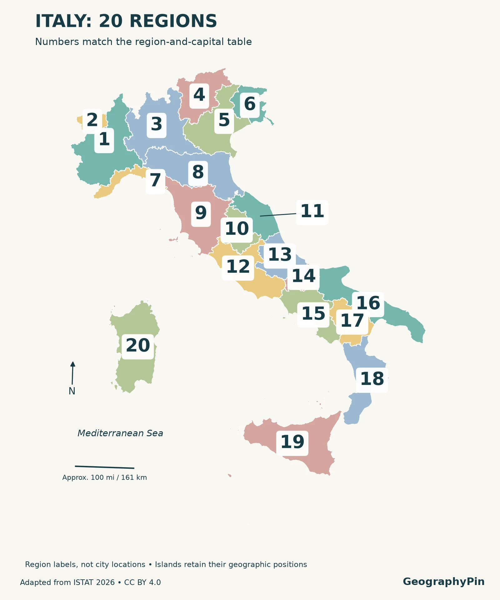
Italy has 20 regions. Their regional capitals include Rome in Lazio, Milan in Lombardy, Florence in Tuscany and Palermo in Sicily. Five regions have special statutes. Trentino-Alto Adige/Südtirol is one region comprising two autonomous provinces; its regional capital is Trento. The map numbers match the complete table below.
Find what you need: Match a map number to its capital, understand why Trento and Bolzano appear separately on some maps, or practice the best-known city–region pairs.
1. Italy regions map and complete capital list
Enlarge map · Download printable map and key · Download the region list
Match the number, region and capital
Common English names appear alongside Italian or official bilingual forms. Parentheses after city names give the local form when it differs. “Capital” here means regional administrative capital, not necessarily the region’s largest or most famous city.
| Map | Region | Italian / bilingual name | Regional capital |
|---|---|---|---|
| 1 | Piedmont | Piemonte | Turin (Torino) |
| 2 | Aosta Valley | Valle d’Aosta / Vallée d’Aoste | Aosta (Aoste) |
| 3 | Lombardy | Lombardia | Milan (Milano) |
| 4 | Trentino-Alto Adige / Südtirol | Trentino-Alto Adige / Südtirol | Trento |
| 5 | Veneto | Veneto | Venice (Venezia) |
| 6 | Friuli-Venezia Giulia | Friuli-Venezia Giulia | Trieste |
| 7 | Liguria | Liguria | Genoa (Genova) |
| 8 | Emilia-Romagna | Emilia-Romagna | Bologna |
| 9 | Tuscany | Toscana | Florence (Firenze) |
| 10 | Umbria | Umbria | Perugia |
| 11 | Marche | Marche | Ancona |
| 12 | Lazio | Lazio | Rome (Roma) |
| 13 | Abruzzo | Abruzzo | L’Aquila |
| 14 | Molise | Molise | Campobasso |
| 15 | Campania | Campania | Naples (Napoli) |
| 16 | Puglia (Apulia) | Puglia | Bari |
| 17 | Basilicata | Basilicata | Potenza |
| 18 | Calabria | Calabria | Catanzaro |
| 19 | Sicily | Sicilia | Palermo |
| 20 | Sardinia | Sardegna | Cagliari |
The table lists Trentino-Alto Adige/Südtirol once, with Trento as its regional capital. Bolzano is the capital of the autonomous province of Bolzano/Bozen within that region, not the capital of a twenty-first region.
2. Read the regional map without mixing levels
A region is not the same unit as a province, metropolitan city or municipality. A detailed map may contain many more internal borders because it depicts smaller units. This map deliberately shows the regional level only. Rome has both a national role and a regional one: it is Italy’s capital and Lazio’s capital.
The two large islands are not detached panels. Sicily and Sardinia remain in their actual relative positions, and each is a region in its own right. Smaller islands belong to regions too; they are not additional entries merely because they are separated from the mainland by water. At this national scale, some are necessarily tiny.
ISTAT also groups the regions into five statistical areas. These are useful organizational categories, not five replacement regions:
- Northwest: Piedmont, Aosta Valley, Lombardy and Liguria.
- Northeast: Trentino-Alto Adige/Südtirol, Veneto, Friuli-Venezia Giulia and Emilia-Romagna.
- Center: Tuscany, Umbria, Marche and Lazio.
- South: Abruzzo, Molise, Campania, Puglia, Basilicata and Calabria.
- Islands: Sicily and Sardinia.
That explains why a statistical table can place Abruzzo in “South” even when a casual description calls it central-southern Italy. Use the stated classification instead of treating everyday directional labels as fixed administrative boundaries.
3. Special-statute regions and autonomous provinces
Article 116 of Italy’s Constitution identifies five regions with special statutes: Aosta Valley, Friuli-Venezia Giulia, Trentino-Alto Adige/Südtirol, Sicily and Sardinia. They remain Italian regions; special status does not make them independent countries. Their arrangements are not identical, so a shared label should not be read as a promise of the same powers everywhere.
One region, two autonomous provinces
Trentino-Alto Adige/Südtirol comprises the autonomous provinces of Trento and Bolzano. The regional statute names Trento as the regional capital. A tourism or statistical map may give the two provinces separate attention because of their distinct roles, but that presentation does not change the twenty-region total.
There is a related statistical trap: European NUTS level 2 data distinguish the two autonomous provinces rather than using one Trentino-Alto Adige/Südtirol unit. ISTAT’s geographic-data documentation explicitly notes this difference. Do not count a NUTS2 dataset and assume that its row count must equal the number of constitutional regions.
For a basic regional map, the dependable check is the unit definition. This illustration uses the ISTAT region layer and its twenty unique region codes, not a mixture of region and province polygons.
4. Learn the map through familiar cities
Use city–region pairs as anchors
Begin with Milan–Lombardy, Venice–Veneto and Florence–Tuscany. Add Rome–Lazio and Naples–Campania, then Palermo–Sicily and Cagliari–Sardinia. Each pair links a city you may already know to one region outline rather than asking you to memorize twenty names without context.
Next cover the capital column and test yourself on the less familiar pairs: L’Aquila–Abruzzo, Campobasso–Molise, Potenza–Basilicata and Catanzaro–Calabria. The goal is to identify the administrative capital, not guess the city with the strongest tourist reputation.
Finally, compare the English and local names. Tuscany and Toscana are the same region; Apulia and Puglia are the same region; Florence and Firenze are the same city. Keeping those equivalents together helps when an English guide, an Italian sign and a map use different labels.
For the broader continental level, our European countries and capitals guide lists national capitals. Here the focus stays inside Italy, at the regional level.
Frequently Asked Questions
Does Italy have 20 regions or 21?
Italy has 20 regions. Some statistical or tourism presentations separate the autonomous provinces of Trento and Bolzano within Trentino-Alto Adige/Südtirol. Those are not two additional regions.
Is Tuscany a city?
No. Tuscany, called Toscana in Italian, is a region. Florence, or Firenze, is its capital. The map outlines the region, while the table names the city.
What Did We Learn Today?
Italy’s twenty regions form a different layer from its cities and provinces. The numbered map and capital table work together: the label identifies an area, not a city coordinate. Sicily and Sardinia count as regions, and Trentino-Alto Adige/Südtirol counts once despite its two autonomous provinces. Matching English names to local forms makes the same geography easier to recognize across sources.
Sources & Data Notes
Map geometry and region codes come from ISTAT’s generalized boundaries for January 1, 2026, released for statistical purposes. GeographyPin reprojected the data from WGS84 UTM zone 32N to ETRS89 / LAEA Europe, applied colors and placed region-number labels against the corresponding polygons, using a leader for Marche to keep nearby numbers readable. The map is an educational overview, not a cadastral or legal-boundary survey. Capital names were cross-checked against ENIT’s regional-capital map and Italy’s toponymic guidelines; the Trentino-Alto Adige statute resolves the regional/provincial distinction.
Boundary data: ISTAT, CC BY 4.0. Changes: reprojection, styling and labels. GeographyPin branding identifies this cartographic presentation, not ownership of the underlying public data or endorsement by ISTAT.
- ISTAT: Administrative boundaries for statistical purposes — region geometry and source date.
- ISTAT: Geographic-data documentation — region codes, statistical areas and NUTS distinctions.
- ISTAT: Legal notice and reuse license.
- ENIT: Italian regions and regional capitals — printed page 12, PDF page 13.
- Italy’s toponymic guidelines, submitted to UNGEGN — 2004 regional-capital list, cross-checked with ENIT; obsolete province totals are not used.
- Italian Government: Constitution, Title V — regional structure and special statutes.
- Trentino-Alto Adige: Regional statute — Article 1 names Trento as capital.