Several national capitals use urban cable cars for everyday public transport, including Mexico City, Bogotá, Caracas, Santo Domingo, Algiers, and Tbilisi. Mi Teleférico serves La Paz, Bolivia’s seat of government, and neighboring El Alto. These systems work best as connectors over steep or congested terrain, not as replacements for every bus or rail corridor.
How to use this article: Start with what counts as public transit, understand the La Paz–Sucre distinction, compare current systems, or use the transit-versus-tourism test.
Why Cities Use Urban Cable Cars
Urban cable cars can cross steep slopes, crowded districts, rivers, rail corridors, and other barriers without following the street network. Towers occupy relatively little ground between stations, and vehicles move continuously above traffic rather than becoming trapped in it.
Urban cable car is a broad category. A gondola lift usually circulates many small cabins on a continuous cable, while an aerial tramway normally shuttles one or two larger cabins between terminals. Spanish terms such as teleférico are often used more broadly, so this comparison follows each operator’s name while classifying systems by what they do.
What counts as public transit?
A cable car qualifies as practical public transport when it serves useful daily destinations, runs on a commuter-friendly schedule, charges an accessible fare, and connects with the wider bus or rail network. Scenic views do not disqualify a line, but a visitor attraction with a trailhead or observation deck as its main destination serves a different purpose.
This article uses a broad national-capital convention while clearly identifying systems located in a capital’s metropolitan area rather than within its municipal boundary.
Where cable transit works best
The strongest corridors usually combine a steep grade or physical barrier with dense passenger demand and a good transfer point. A gondola can turn a slow switchback bus journey into a short, predictable connection to a metro or bus rapid transit station.
This explains the model’s close relationship with social inclusion. Lower-income neighborhoods often occupy slopes where roads are narrow, indirect, or difficult to expand. A well-placed line can improve access to jobs, schools, health care, and other services without clearing a continuous right-of-way through the community.
What cable cars cannot do
Cable systems have moderate capacity and fixed, usually linear routes. They cannot replace heavy rail or a high-capacity bus corridor everywhere, and stations still require land, walking access, feeder services, maintenance facilities, and emergency planning.
Electric operation produces no exhaust at the cabin, but the full environmental result depends on the electricity supply, construction, and how many road trips the line actually replaces. High winds, lightning, technical inspections, or legal and land-use disputes can also interrupt service.
La Paz, Bolivia — Mi Teleférico: The Network-Scale Model
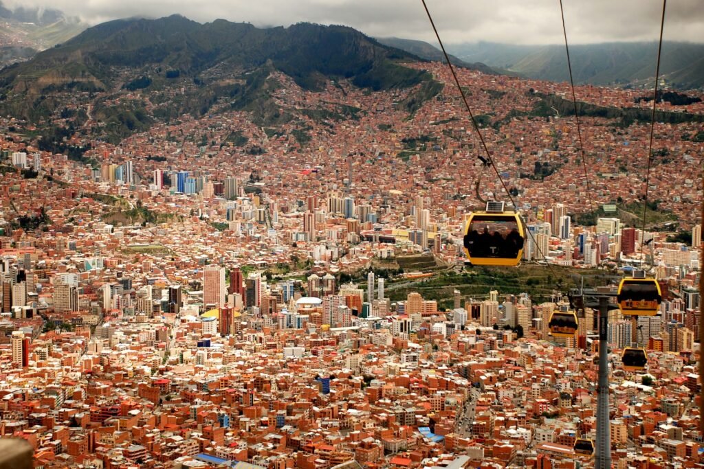
Mi Teleférico opened its first lines in 2014 and grew from an ambitious connector into a metropolitan network. It links the lower basin of La Paz with El Alto, whose plateau stands roughly 1,300 feet (400 meters) above parts of the city below.
Why La Paz belongs in a capital-city comparison
Bolivia’s Constitution names Sucre as the national capital. La Paz is the seat of the national government and is commonly described as the country’s administrative or de facto capital. That distinction matters: La Paz’s role in Bolivia makes it relevant to this comparison without erasing Sucre’s constitutional status.
Mi Teleférico is also metropolitan rather than confined to one municipality. Its importance comes from connecting La Paz and El Alto as one urban labor and travel market.
Network and daily use
Mi Teleférico’s 2025 management reporting listed 10 commercial lines, 36 stations, more than 1,300 cabins, and approximately 19.6 miles (31.6 kilometers) of route. Official operating material also reported more than 230,000 passenger trips on a typical day (Mi Teleférico, 2025).
The scale separates La Paz–El Alto from most urban cable projects. Many cities use one gondola as a feeder; Mi Teleférico allows transfers among color-coded lines and performs a broader network role.
Why the geography fits
Road travel between the plateau and canyon follows limited, heavily used approaches. Cable lines cross the vertical difference directly and provide travel times that are less exposed to street congestion. Mi Teleférico describes the Purple Line’s center-to-center journey between El Alto and La Paz as approximately 16 minutes.
The cabins have also become a recognizable part of the skyline, but sightseeing appeal is secondary to the network’s frequent service, ordinary fares, and daily passenger volume.
Mexico City, Mexico — Cablebús: Three Lines Above the Roads
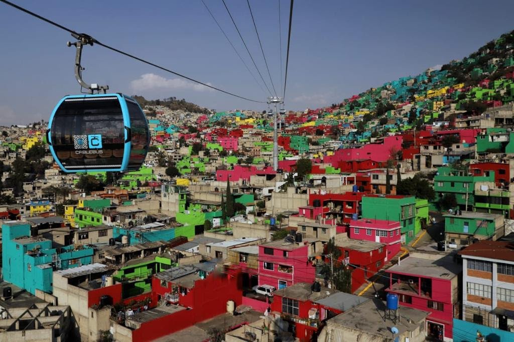
Mexico City introduced Cablebús in 2021 to improve access from densely populated outer districts where steep terrain and indirect roads produced long commutes. The network now has three lines: the original routes in Gustavo A. Madero and Iztapalapa, plus a western line opened in 2024.
From two lines to three
Line 1 runs about 5.7 miles (9.2 kilometers) through six stations between Cuautepec and Indios Verdes. Line 2 covers approximately 6.6 miles (10.55 kilometers) through seven stations in Iztapalapa. Line 3 adds a 3.4-mile (5.5-kilometer), six-station connection through the Chapultepec area toward western Mexico City (Mexico City SEMOVI and STE, 2024–2025).
The lines are not isolated attractions. Their stations connect passengers with Metro, bus rapid transit, and other parts of the city’s mobility network.
Time savings and network integration
Official figures put Line 1’s scheduled journey at about 33 minutes instead of roughly 80 minutes by previous road-based travel. Line 2 reduced a comparable journey from around 75 minutes to 36 minutes. Transport-planning research reports that Lines 1 and 2 together serve more than 100,000 passenger trips per day and that Line 1 reduced travel time by nearly 45% (ITDP, 2024).
The lasting benefit comes from combining the aerial segment with onward transit. Cablebús solves a difficult first or last section of the journey; the Metro and bus network still carry passengers across the wider capital.
Bogotá, Colombia — TransMiCable: A BRT Feeder in the Hills
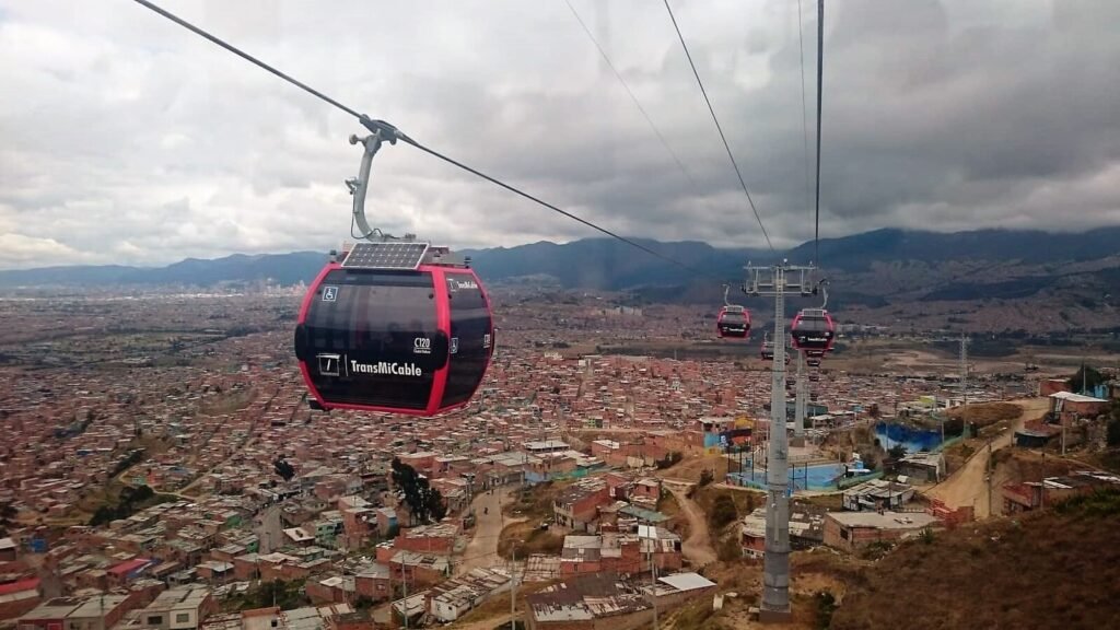
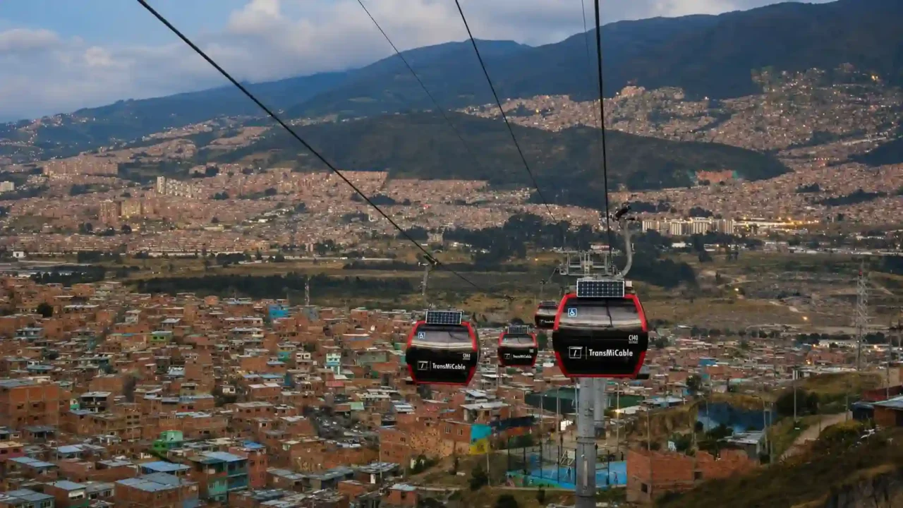
Bogotá opened the Ciudad Bolívar TransMiCable line in late 2018. The 2.1-mile (3.34-kilometer) route has four stations and 163 cabins, linking the hillside terminal at Mirador del Paraíso with the Tunal portal of the TransMilenio bus rapid transit system.
The 13-minute link to TransMilenio
Current rider information from TransMilenio describes a peak-period journey that previously took about an hour and now takes approximately 13 minutes on the cable segment. Bogotá recorded an average of about 25,475 daily validations on the line in 2025 (Bogotá city government, 2025).
Passengers can transfer into the wider integrated system at Tunal. That connection is central to the project’s value: the cable car does not carry riders to every major job center, but it makes the difficult hillside section much faster and more reliable.
What the cabin solar panels actually do
The small solar panels visible on TransMiCable cabins support onboard electrical equipment and emergency functions. They do not provide the traction power that moves the cable; station equipment drives the system using the electrical supply.
Describing the entire line as solar-powered would therefore be misleading. Its environmental case rests on electric operation, short and direct journeys, and the potential to replace slower road trips—not on the cabin panels powering the route.
Caracas, Venezuela — Metrocable and Social Infrastructure
Caracas opened the San Agustín Metrocable in 2010 to connect a steep, densely built hillside with the central Metro network. The approximately 1.3-mile (2.1-kilometer) line has five stations and was designed to carry about 1,200 passengers per hour in each direction.
Transit link and community design
The route connects San Agustín with Parque Central, avoiding long stair climbs and indirect road trips to the Metro. Intermediate stations were conceived as more than boarding points, with community facilities and public services forming part of the project’s social-infrastructure approach.
A second cable corridor at Mariche extended the model to another peripheral district. Together, the projects showed how an aerial feeder could be planned around neighborhood access rather than visitor demand.
Why current service status needs checking
Caracas cable lines have experienced temporary suspensions, inspections, and rehabilitation work. A route’s operating status should therefore be checked with Metro de Caracas before a time-sensitive trip.
This does not change Metrocable’s public-transit purpose, but it makes claims about uninterrupted service or current daily ridership less stable than equivalent figures for La Paz or Mexico City.
Other Capital-City Systems and Cautionary Cases
Capital-area cable transit extends beyond the best-known Latin American examples. The comparison below is selective rather than exhaustive, and it distinguishes systems inside a capital city from routes serving its wider metropolitan region.
Current systems at a glance
| Capital area | System and opening | Scale in this comparison | Transit role and status |
|---|---|---|---|
| La Paz–El Alto | Mi Teleférico, 2014 | 10 lines, 36 stations, about 19.6 miles (31.6 kilometers) | Active metropolitan network serving Bolivia’s seat of government |
| Mexico City | Cablebús, 2021 | Three lines | Active connectors to Metro, BRT, and other urban transit |
| Bogotá | TransMiCable, 2018 | One operating 2.1-mile (3.34-kilometer) line; more lines in development | Active feeder to TransMilenio |
| Caracas | Metrocable, 2010 | San Agustín and Mariche corridors | Public-transit system with route status affected at times by rehabilitation |
| Santo Domingo metropolitan area | Teleférico de Santo Domingo, 2018 | Two lines | Active service integrated with Metro or feeder-bus connections |
| Algiers | Urban ropeways; first line opened in 1956 | Several cable-car and gondola corridors | Long-running urban mobility network; individual lines may close for inspection or renewal |
| Tbilisi | Bagebi–University ropeway, reopened in 2021 | About 0.2 miles (0.32 kilometers), two stations | Small municipal connector included in the integrated transit fare |
| Greater Paris | Câble C1, 2025 | 2.8 miles (4.5 kilometers), five stations | Active regional transit outside Paris’s municipal boundary |
Two details deserve emphasis. Algiers has one of the longest histories of urban ropeway transport, although individual corridors rotate through inspection and modernization. Greater Paris’s Câble C1 opened on December 13, 2025, connecting the terminus of Metro Line 8 at Créteil–Pointe du Lac with communities farther southeast; it is a capital-region system, not a line inside central Paris (Île-de-France Mobilités, 2025).
Ankara: a former transit example
Ankara’s Yenimahalle–Şentepe Teleferik opened in 2014 as a four-station, 2-mile (3.257-kilometer) feeder between a Metro station and a hillside residential district. It once belonged on a list of operating capital-city systems.
Ankara’s EGO transit authority closed the line indefinitely on April 26, 2024, after a court decision annulled the development plan governing the installation. Municipal records in 2026 still treated the route as closed. It remains an instructive historical case, but it should not be presented as active public transit.
Antananarivo: opening does not guarantee stable service
Antananarivo’s 5.4-mile (8.7-kilometer) Orange Line began carrying the public on a limited schedule in August 2025. Subsequent operational, funding, governance, and protest-related disruptions left its stable long-term service status uncertain (French Senate records, 2026).
The case shows why an inauguration date alone is insufficient. A line becomes dependable public transit only when it sustains regular operations, maintenance, staffing, fares, and connections that residents can plan around.
Public Transit vs. Tourist Cable Cars
Not every cable car in a capital performs the same job. Some are fully integrated commuter links, some occupy a mixed category, and others are primarily recreational attractions.
A practical four-part test
- Endpoints: Does the line connect homes, workplaces, schools, or major transit stations rather than mainly a viewpoint?
- Fares: Is the price comparable with local transit, and can passengers use the same card or transfer arrangement?
- Schedule: Does service cover normal commuting periods throughout the year?
- Network role: Is the route planned and operated as part of the city’s mobility system?
A line does not need to satisfy every test perfectly. London, for example, is a mixed case: it is operated by a transport authority and connects two districts, but its fare structure and demand are more visitor-oriented than those of La Paz or Bogotá.
Quito’s TelefériQo
Quito’s TelefériQo carries passengers approximately 1.6 miles (2.5 kilometers) from the city’s edge to Cruz Loma at roughly 12,950 feet (3,947 meters). Its upper terminal serves a viewpoint, recreation area, and mountain trails rather than a residential district or employment center.
The route is an important city attraction, but its destinations, pricing, and trip purpose place it outside the commuter-transit category used here.
London’s IFS Cloud Cable Car
London’s cable car crosses the Thames between Greenwich Peninsula and the Royal Docks and is operated within the Transport for London system. Passengers can pay with Oyster or contactless cards, and the terminals connect with other modes.
However, the cable car has a separate fare that does not count toward normal daily caps, demand is strongly seasonal, and Transport for London markets the crossing as an experience. It is more accurate to call it a mixed transport and visitor service than either a core commuter line or a tourism-only ride.
What Comes Next for Capital-City Cable Transit
Several capital projects are under construction, testing, or study. Their announced dates are targets rather than proof of future operation, as construction, certification, funding, and political decisions can alter schedules.
Santiago’s commuter project
Santiago is Chile’s capital, contrary to some earlier descriptions of the project. The Teleférico Bicentenario is being built as a public-transport connection between Providencia and Huechuraba, with three stations and a route of approximately 2.1 miles (3.4 kilometers).
Chile’s published project schedule targeted service in 2027. This commuter line should not be confused with Santiago’s park cable cars, whose main purpose is recreation and sightseeing.
Bogotá’s next lines
Bogotá’s San Cristóbal cable line entered testing in 2026, with passenger service targeted for December after technical certification. A further line in the Potosí area of Ciudad Bolívar is also in development, with an announced 2027 goal.
Both dates remain project schedules. Their significance lies in Bogotá’s effort to repeat the TransMiCable feeder model in other steep districts rather than turning one successful corridor into a citywide substitute for buses or rail.
Kigali’s proposal
The African Development Bank approved funding for a feasibility study of a proposed 3.4-mile (5.5-kilometer) urban cable-car phase in Kigali. Published plans envisioned construction beginning in late 2026 and commissioning in 2028, with projected demand above 50,000 passenger trips per day.
Those figures describe a proposal and its design case, not an operating system. Kigali should move into the confirmed-service category only after construction, testing, and regular public operations occur.
Frequently Asked Questions
Which capital cities currently use cable cars for commuting?
Clear examples include Mexico City, Bogotá, Caracas, Santo Domingo, Algiers, and Tbilisi. Mi Teleférico serves La Paz, Bolivia’s seat of government, and El Alto. Greater Paris also has Câble C1, although its route lies outside the municipality of Paris. Local maintenance can temporarily affect individual lines.
Is La Paz officially Bolivia’s capital?
Bolivia’s Constitution identifies Sucre as the capital. La Paz is the seat of the national government and is widely called the administrative or de facto capital. The article includes La Paz on that clearly stated basis.
How does cable-car capacity compare with buses or trains?
Urban gondolas generally provide moderate corridor capacity. They can move passengers continuously and work well as feeders, but heavy rail and the busiest bus rapid transit lines can carry substantially more people. Cabin size, spacing, operating speed, and station design determine each line’s capacity.
Are urban cable cars cheaper to build than subways?
They often cost less where a route can cross steep or obstructed ground without tunneling or building a continuous elevated structure. That is not a universal rule: stations, land, utility relocation, tower foundations, imported equipment, and long-term maintenance can raise costs significantly.
Do urban cable cars operate in bad weather?
Modern systems can run in rain and many ordinary weather conditions, but strong wind, lightning, ice, or poor visibility may require reduced speed or temporary closure. Safety thresholds differ by equipment and location, and scheduled inspections can also suspend service.
What Did We Learn Today?
Capital-area cable cars become genuine transit when they connect useful origins and destinations, run on practical schedules, and integrate with fares and bus or rail networks. La Paz demonstrates the network-scale model, while Mexico City, Bogotá, and other capitals show the connector approach. Ankara, Antananarivo, Quito, and London also show why legal status, reliability, location, and trip purpose matter.
Sources & Data Notes
System status and figures were checked against Bolivia’s Constitution, Mi Teleférico, Mexico City’s Secretariat of Mobility and Electric Transport Service, TransMilenio and Bogotá city records, Metro de Caracas, Ankara EGO and municipal records, OPRET and Dominican government material, ETAC/POMA, Tbilisi Transport Company, Île-de-France Mobilités, Chilean government project information, French Senate records, the African Development Bank, and ITDP research. Route lengths, travel times, capacity, and ridership are rounded; daily riders, passenger trips, and validations are not always interchangeable, while operating and construction status can change after maintenance, legal decisions, or schedule revisions. This article was prepared and editorially reviewed by Z.K. Atlas, who completed the final factual checks and publication approval and accepts publication responsibility. AI tools may have assisted during the editorial process, including with language refinement and the creation or editing of visual materials.