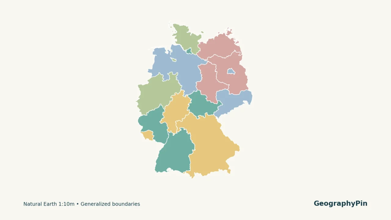
Germany’s national capital is Berlin, but a map of its federal states introduces fifteen other state names and a separate set of capital-city pairs. Some pairs are familiar, such as Bavaria and Munich. Others are easy to confuse: Hesse’s capital is Wiesbaden, not Frankfurt.
Germany has 16 federal states, called Länder. Berlin, Hamburg and Bremen are the three city-states; Bremen includes the separate cities of Bremen and Bremerhaven. Each state has a capital. The numbered map and table identify all sixteen, with German names alongside their common English equivalents.
Find what you need: Match map numbers to state capitals, see why Bremen appears in two places, or review commonly confused capitals.
1. Germany states map and complete capital list
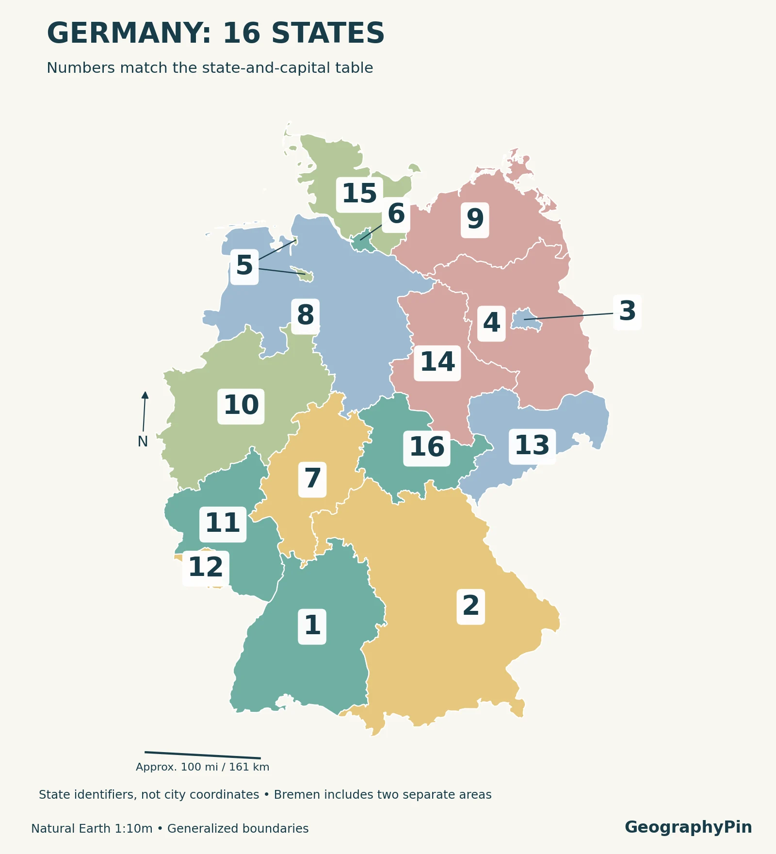
Enlarge map · Download printable map and key · Download the state list
Match each number to its state and capital
| Map | State in English | German name | State capital |
|---|---|---|---|
| 1 | Baden-Württemberg | Baden-Württemberg | Stuttgart |
| 2 | Bavaria | Bayern | Munich (München) |
| 3 | Berlin | Berlin | Berlin |
| 4 | Brandenburg | Brandenburg | Potsdam |
| 5 | Bremen | Bremen | Bremen |
| 6 | Hamburg | Hamburg | Hamburg |
| 7 | Hesse | Hessen | Wiesbaden |
| 8 | Lower Saxony | Niedersachsen | Hanover (Hannover) |
| 9 | Mecklenburg-Western Pomerania | Mecklenburg-Vorpommern | Schwerin |
| 10 | North Rhine-Westphalia | Nordrhein-Westfalen | Düsseldorf |
| 11 | Rhineland-Palatinate | Rheinland-Pfalz | Mainz |
| 12 | Saarland | Saarland | Saarbrücken |
| 13 | Saxony | Sachsen | Dresden |
| 14 | Saxony-Anhalt | Sachsen-Anhalt | Magdeburg |
| 15 | Schleswig-Holstein | Schleswig-Holstein | Kiel |
| 16 | Thuringia | Thüringen | Erfurt |
Parentheses give a German city name where the English spelling differs. Hanover and Hannover refer to the same city, as do Munich and München. The map labels locate the states; they are not plotted coordinates for the capitals.
On a small screen, use the numbers rather than trying to fit sixteen long state names inside the map. Enlarge the image for the smallest boundaries, and use the Bremen detail below to understand its two separated areas.
2. Berlin, Hamburg and Bremen: the city-states
Most German states contain many municipalities across a broad territory. Berlin and Hamburg instead combine city and state status. Bremen is also classified as a city-state, but its structure needs one extra explanation: the state consists of two cities, Bremen and Bremerhaven.
Berlin is a state in its own right, not part of Brandenburg. Potsdam is Brandenburg’s capital. Likewise, Hamburg is a separate state, not a city belonging to Lower Saxony or Schleswig-Holstein. Tiny-looking areas on a national map can therefore have the same federal-state status as the much larger surrounding areas.
Bremen is one state with two cities
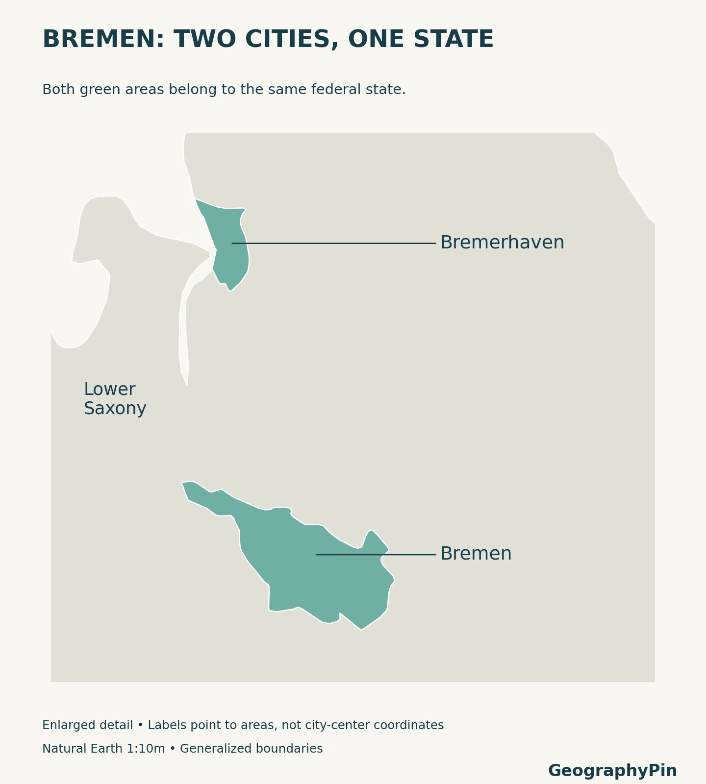
The northern area is Bremerhaven; the southern area is Bremen. The city of Bremen is also the state capital. The state’s own official portal describes it as Germany’s only two-city state. This is why counting separate colored patches instead of named administrative units would give the wrong answer.
3. Names and capital-city mix-ups
A famous city is not always the capital
Frankfurt’s international profile can make it the tempting answer for Hesse, but the state capital is Wiesbaden. In North Rhine-Westphalia, the answer is Düsseldorf, not Cologne. The table is an administrative-capital list, not a list of each state’s best-known destination.
The three names containing “Saxony” are another common source of confusion. Lower Saxony, Saxony and Saxony-Anhalt are separate states. Their capitals are Hanover, Dresden and Magdeburg respectively. They should not be combined into a single entry simply because part of their English names matches.
English and German names can also look very different without referring to different places. Bavaria is Bayern, Hesse is Hessen and Thuringia is Thüringen. Using the two name columns together helps when an English atlas and a German-language source label the same state differently.
For practice, cover the final column and try these five pairs: Bavaria–Munich, Brandenburg–Potsdam, Hesse–Wiesbaden, Saxony–Dresden and Schleswig-Holstein–Kiel. Then locate each state on the numbered map. Learning a city and its surrounding administrative area together is more useful than memorizing either list in isolation.
4. What a federal state means
The German word Land is singular; Länder is plural. Bundesland and Bundesländer are also used to distinguish these federal states from other meanings of Land. In this context, the English word “state” means a constituent part of Germany, not an independent country.
Germany’s federal system divides responsibilities between the federal level and the Länder. The Federal Agency for Civic Education uses schools and policing as examples of major state responsibilities. The states also participate in federal legislation through the Bundesrat. That institutional role is why this map is more than a convenient collection of regional names.
Keep the geographic levels separate: Germany is the country, Bavaria is a federal state, and Munich is a city and Bavaria’s capital. Berlin has overlapping roles because it is both the national capital and a federal state. For the continental level, our European countries and capitals guide lists national capitals rather than the capitals of Germany’s internal states.
Frequently Asked Questions
Does Germany have 16 or 17 states?
Germany has 16 federal states. Bremen and Bremerhaven are two cities in one state, not two separate states. The map therefore gives both Bremen areas the same number.
Is Bavaria a country?
Bavaria is a federal state within Germany. Its German name is Bayern and its capital is Munich, or München.
Is Berlin the capital of Brandenburg?
No. Brandenburg’s capital is Potsdam. Berlin is Germany’s national capital and a separate federal state.
What Did We Learn Today?
Germany has sixteen federal states, each with its own capital. Berlin, Hamburg and Bremen are the city-states, but Bremen includes two separate cities. A state’s capital is not necessarily the city that comes to mind first, and English and German labels may differ. The map numbers, bilingual names and capital table describe the same sixteen administrative units.
Sources & Data Notes
State–capital pairs were cross-checked against the Federal Agency for Civic Education and deutschland.de’s state profiles. Only the stable state and capital information is used from the older federalism table, not its population or voting figures. Bremen’s two-city structure is confirmed by the state’s official portal.
The maps use the sixteen German state features in Natural Earth’s public-domain 1:10 million administrative dataset, reprojected to ETRS89 / LAEA Europe. Number anchors were checked against their corresponding polygons; Bremen’s two component areas receive one identifier. Borders and small islands are generalized, so these educational maps are not legal-boundary or cadastral surveys. Colors have no statistical meaning. GeographyPin created the styling and labels; the underlying geographic data come from Natural Earth.
- Federal Agency for Civic Education: Federalism and federal states — complete state–capital table.
- deutschland.de: Germany’s federal states — English-language state profiles and capitals.
- Federal Agency for Civic Education: Länder and federalism — sixteen states, city-states and federal responsibilities.
- Bremen state portal: Two-city state — Bremen and Bremerhaven.
- Federal government portal: Hesse — Wiesbaden and Frankfurt distinction.
- Federal government portal: North Rhine-Westphalia — Düsseldorf as capital.
- Natural Earth: Admin 1 states and provinces and public-domain terms of use — geographic data and reuse terms.