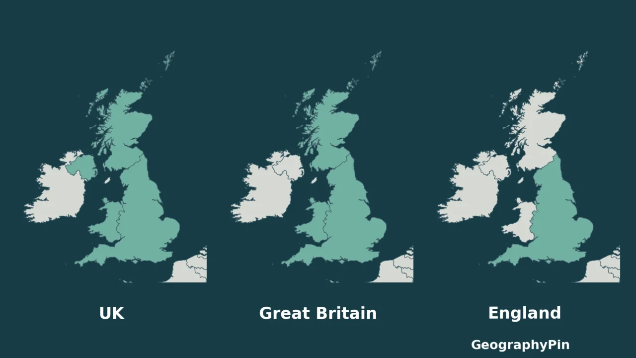
These names overlap, but they do not describe the same area. The easiest way to avoid mixing them up is to ask what kind of thing each name represents: a state, an island or a constituent country.
The United Kingdom includes England, Scotland, Wales and Northern Ireland. England is one of those constituent countries. Great Britain is the island containing most of England, Scotland and Wales; in UK statistics, the name groups those three countries, including their associated islands. Northern Ireland belongs to the UK, but not to Great Britain.
Start here: use the four-country map, check the two uses of Great Britain, or separate Ireland from Northern Ireland.
1. The UK Has Four Constituent Countries
Read the colors as parts of one state
The UK is the United Kingdom of Great Britain and Northern Ireland. The Office for National Statistics lists England, Northern Ireland, Scotland and Wales as its constituent countries. Calling them countries does not mean they are four separate sovereign states.
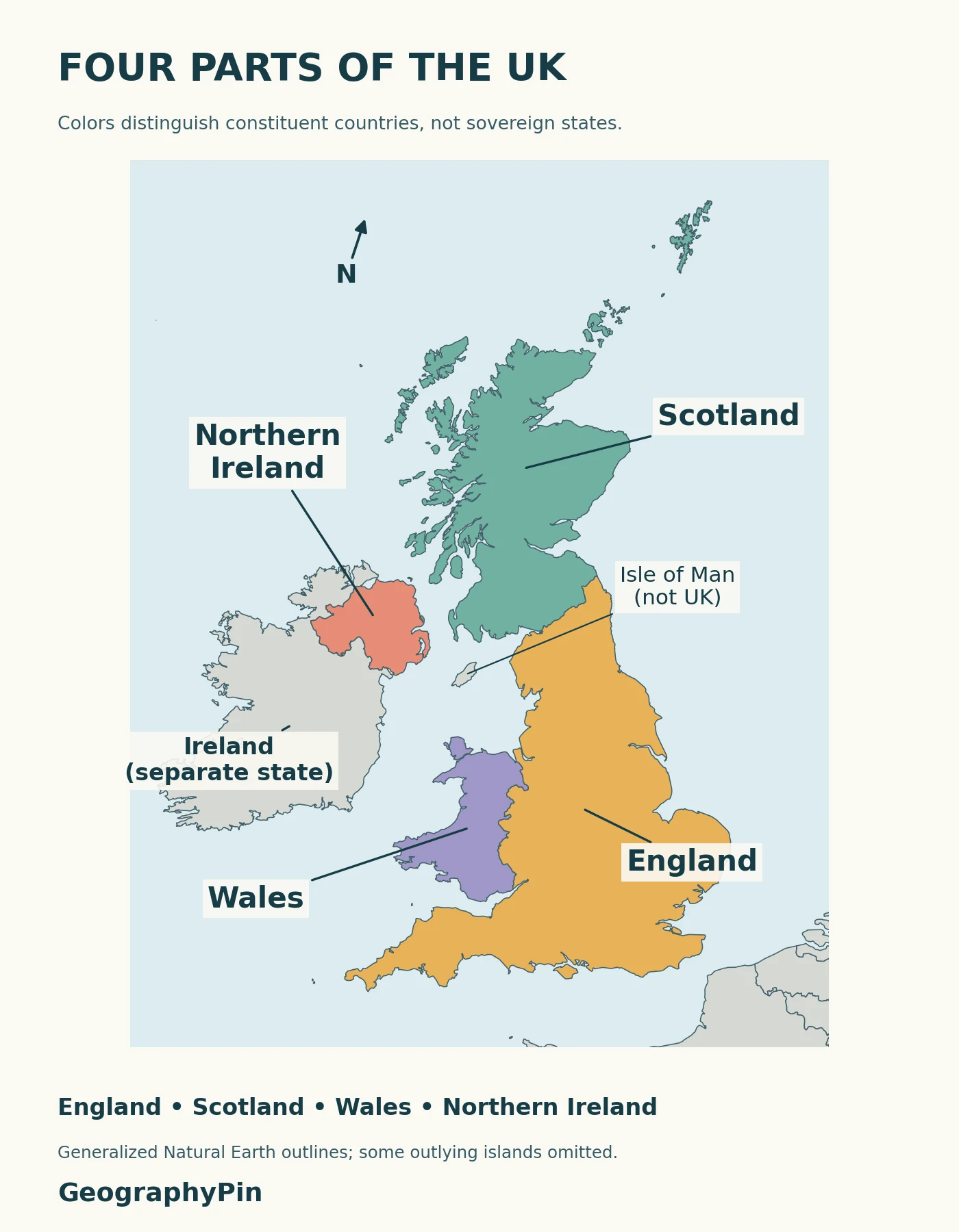
England is therefore neither a synonym for the UK nor the name for all of Great Britain. Using “England” for a statistic that also includes Scotland, Wales and Northern Ireland changes its stated geographic coverage.
| Constituent country | UK | Great Britain in UK statistics |
|---|---|---|
| England | Yes | Yes |
| Scotland | Yes | Yes |
| Wales | Yes | Yes |
| Northern Ireland | Yes | No |
The table is a membership comparison, not a ranking of political importance. A separate color on this map helps identify a constituent country; it is not a claim that every colored boundary has the same constitutional status as an international border.
2. Great Britain: Island or Statistical Grouping?
Do not confuse the physical island with the country total
In physical geography, Great Britain names the large island east of Ireland. The countries of England, Scotland and Wales occupy that island and also have associated offshore islands. A coastline map and a statistical grouping are consequently answering slightly different questions.
When ONS groups England, Scotland and Wales as Great Britain, it is combining those countries, not removing all of their offshore islands. The diagram below uses that statistical meaning. It should not be read as a claim that every island belonging to Scotland or England is physically part of the single island of Great Britain.
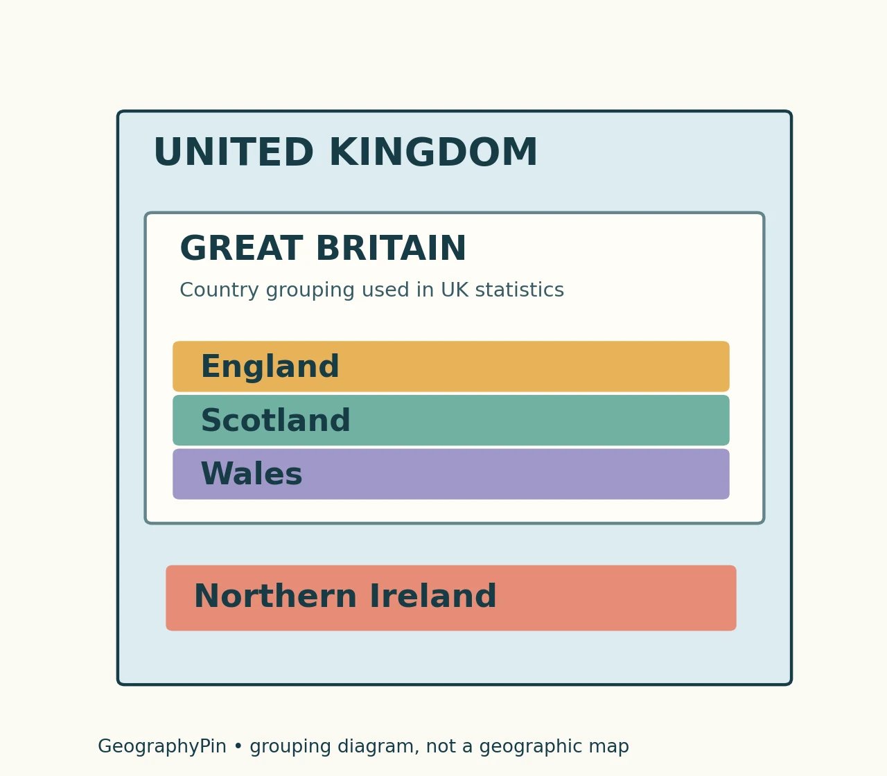
The practical test is Northern Ireland. If a dataset excludes it but combines the other three constituent countries, calling that total “UK” would overstate its coverage. Conversely, a UK total should not be relabeled “Great Britain” without checking its definition.
3. Ireland and the Crown Dependencies Are Different Cases
Ireland can mean an island or a state
The island of Ireland contains Northern Ireland and the state called Ireland, also described as the Republic of Ireland to distinguish it from Northern Ireland. Northern Ireland is part of the UK. The state of Ireland is not.
That distinction prevents two opposite errors: saying that all of Ireland is in the UK, or saying that no part of the island is. On the map, the international boundary separates Northern Ireland from Ireland; the coastline alone does not tell you the political division.
The Isle of Man is another case. It lies between Great Britain and Ireland, but its location does not make it part of the UK. The Ministry of Justice identifies the Isle of Man, the Bailiwick of Jersey and the Bailiwick of Guernsey as Crown Dependencies outside the UK.
These dependencies have their own constitutional relationships with the Crown. They should not simply be added as fifth, sixth and seventh constituent countries. Nor should a mapmaker use a general “British” label as a substitute for explaining which jurisdiction is actually included.
4. Match the Name to the Question
Before comparing a map, a population figure or a travel description, check its geographic unit. “England and Wales,” “Great Britain” and “UK” are different combinations. A source can be accurate for one combination without being a valid answer for another.
- Find the definition. Does the source mean the state, the physical island or a grouping used in statistics?
- Check Northern Ireland. Its inclusion distinguishes the UK total from the usual Great Britain grouping.
- Check offshore areas. Do not assume a physical-island outline and a constituent-country boundary include identical land.
- Keep the label attached. When quoting a figure, retain the geographic coverage used by the original source.
The same habit helps when reading a map of Europe’s countries: physical geography and political membership are different layers. Clear labels matter more than assuming that every familiar place name describes a sovereign state.
Frequently Asked Questions
Why does the country code GB refer to the United Kingdom?
Codes are assigned identifiers, not complete geographic definitions. The UK’s official toponymic guidance gives GB and GBR as its ISO country codes. The letters do not mean that Northern Ireland is excluded from the state represented by that code.
Does “British” mean the same as “English”?
No. English relates to England, while British is also used for the UK more broadly. Official geographical-name guidance notes that “British government” refers to the UK government. The adjective is not a reliable shortcut for deciding whether a source covers only the physical island of Great Britain.
What Did We Learn Today?
England is one constituent country of the UK, not a replacement name for the whole state. Great Britain can describe a physical island or the grouping of England, Scotland and Wales used in statistics. Keeping that distinction clear, and checking Northern Ireland separately, prevents many misleading map labels and comparisons.
Sources & Data Notes
The comparison follows ONS constituent-country terminology. The original map uses Natural Earth’s public-domain 1:10 million map units, which distinguish England, Scotland, Wales and Northern Ireland. It uses an ETRS89 Lambert azimuthal equal-area projection, generalized boundaries and a regional window; it is not a cadastral or navigation map. The nested diagram deliberately uses the statistical grouping of Great Britain rather than a physical-island boundary.
- ONS: Countries and regions — constituent-country groupings and Ireland terminology.
- Ministry of Justice: Crown Dependencies — status of Jersey, Guernsey and the Isle of Man.
- Permanent Committee on Geographical Names: UK toponymic guidelines, section 10 — geopolitical names, the adjective British and country codes.
- Natural Earth: Admin 0 map units and public-domain terms — cartographic source and reuse rights.
- Ordnance Survey: Britain’s largest islands — distinguishes the physical island of Great Britain from surrounding islands.