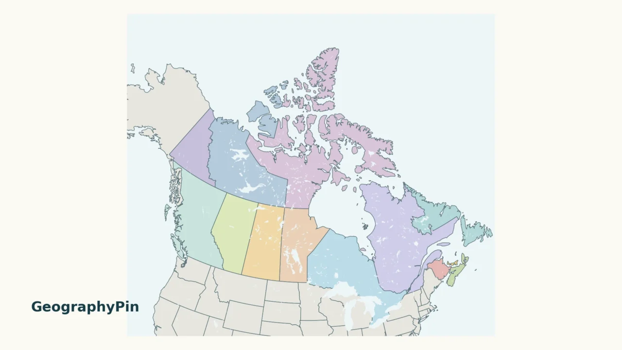
A map of Canada needs room for both the Arctic islands and the small Atlantic provinces. This guide pairs a national overview with a closer Atlantic view, then connects every map number to its province or territory and capital. It is a location reference, not a map of population or travel distances.
Canada has 10 provinces and 3 territories. The provinces extend from British Columbia on the Pacific coast to Newfoundland and Labrador in the east. Yukon, the Northwest Territories and Nunavut occupy the north. Ottawa is the national capital, while each province and territory has its own capital city.
1. Canada provinces and territories map
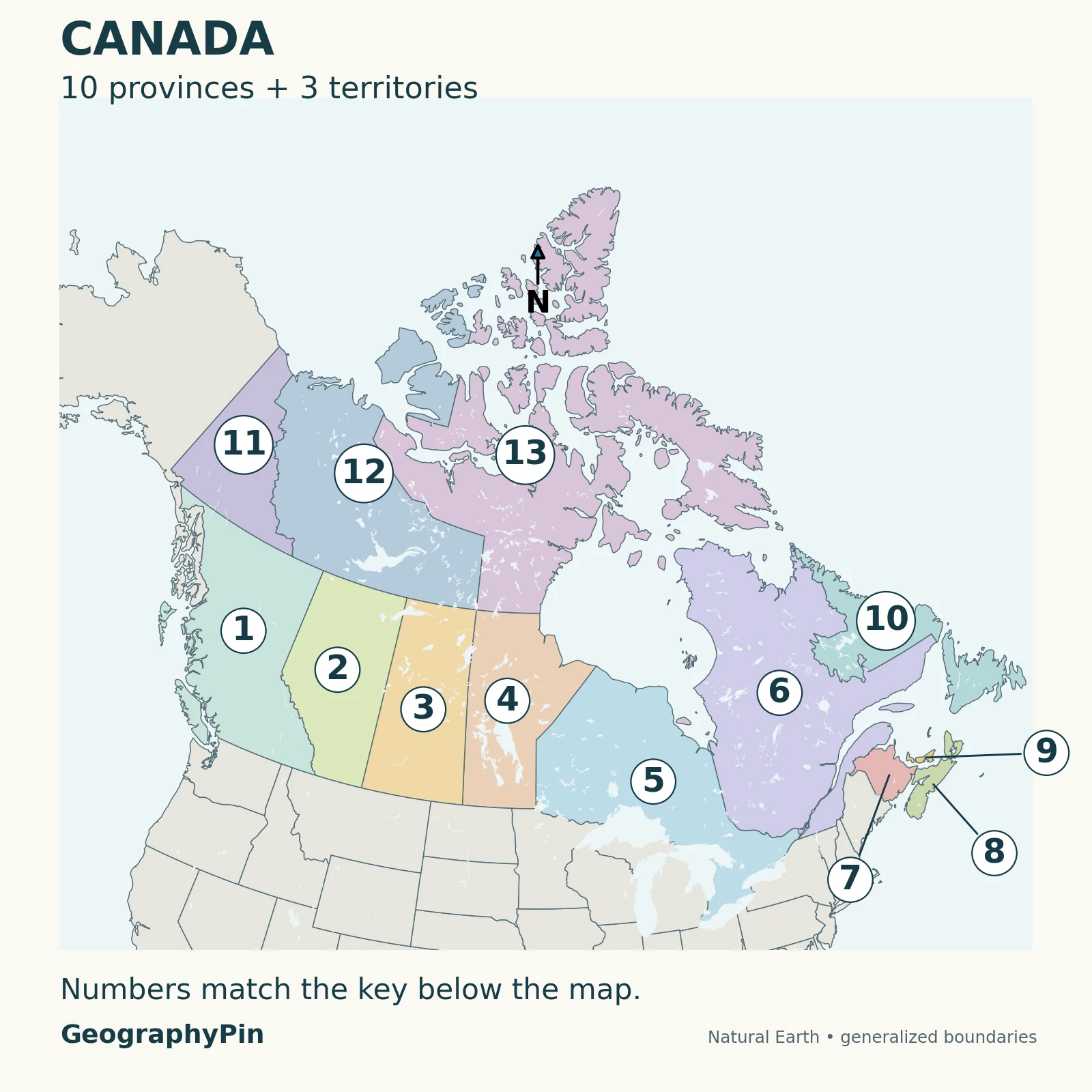
Map key: 10 provinces, then 3 territories
- British Columbia — province
- Alberta — province
- Saskatchewan — province
- Manitoba — province
- Ontario — province
- Québec — province
- New Brunswick — province
- Nova Scotia — province
- Prince Edward Island — province
- Newfoundland and Labrador — province
- Yukon — territory
- Northwest Territories — territory
- Nunavut — territory
The numbers identify areas, not cities. For example, 10 is placed in Labrador, but it identifies the whole province of Newfoundland and Labrador, including the island of Newfoundland. The Atlantic leaders point to small provinces without enlarging their actual outlines.
Start in the west with British Columbia, then move east through Alberta, Saskatchewan and Manitoba. Ontario and Quebec lie farther east, around and beyond the Great Lakes–St. Lawrence region. Above the western provinces are Yukon and the Northwest Territories; Nunavut extends across a large mainland and Arctic-island area. Do not use a single north–south line to divide provinces from territories: their outlines are more complicated than that.
To practice, cover the key and name the numbered areas. Use the map key above to check your answers, then try again in a different order. The colors help keep neighboring outlines separate, but learning the names and relative positions is more useful than memorizing a color.
2. The complete capital list
Provincial and territorial capitals
| Map number | Province or territory | Type | Capital |
|---|---|---|---|
| 1 | British Columbia | Province | Victoria |
| 2 | Alberta | Province | Edmonton |
| 3 | Saskatchewan | Province | Regina |
| 4 | Manitoba | Province | Winnipeg |
| 5 | Ontario | Province | Toronto |
| 6 | Québec | Province | Québec City |
| 7 | New Brunswick | Province | Fredericton |
| 8 | Nova Scotia | Province | Halifax |
| 9 | Prince Edward Island | Province | Charlottetown |
| 10 | Newfoundland and Labrador | Province | St. John’s |
| 11 | Yukon | Territory | Whitehorse |
| 12 | Northwest Territories | Territory | Yellowknife |
| 13 | Nunavut | Territory | Iqaluit |
Download the province and capital list
A capital is a seat of government, not automatically the best-known city. British Columbia’s capital is Victoria, not Vancouver. Alberta’s is Edmonton, not Calgary. Saskatchewan’s is Regina, not Saskatoon. Quebec’s is Québec City, not Montréal.
Keep the national and provincial levels separate. Ottawa is Canada’s national capital and is in Ontario; Toronto is Ontario’s provincial capital. Ottawa is not an additional province or territory, so it does not become a fourteenth row in this table.
The capital list follows the Government of Canada’s Discover Canada regional reference. The map does not plot capital-city coordinates: numbered labels indicate the larger administrative areas rather than the locations of their governments.
3. Provinces and territories are not the same category
The difference concerns the source of their powers
Provinces exercise constitutionally recognized legislative powers. Territorial governments exercise powers delegated under federal law. That is the basic constitutional distinction, not a claim that the territories have no elected governments or simply function as remote federal offices.
The federal government has transferred many province-like responsibilities to territorial governments through devolution. The details differ by territory and responsibility, so a two-color map cannot summarize the full legal arrangement. Canada’s Intergovernmental Affairs explanation is the primary reference for this distinction.
Administrative boundaries also do not tell the whole story of governance. Indigenous rights, treaties and self-government arrangements are not drawn on this map. Canada’s Department of Justice constitutional overview explains that Indigenous governments can exercise powers through different legal arrangements. A provincial or territorial outline should not be read as a complete map of those rights or governments.
For a broader continental reference, see the North American countries and capitals list. Canada is one country within that wider map; its provinces and territories are not additional sovereign countries.
4. Reading Atlantic Canada
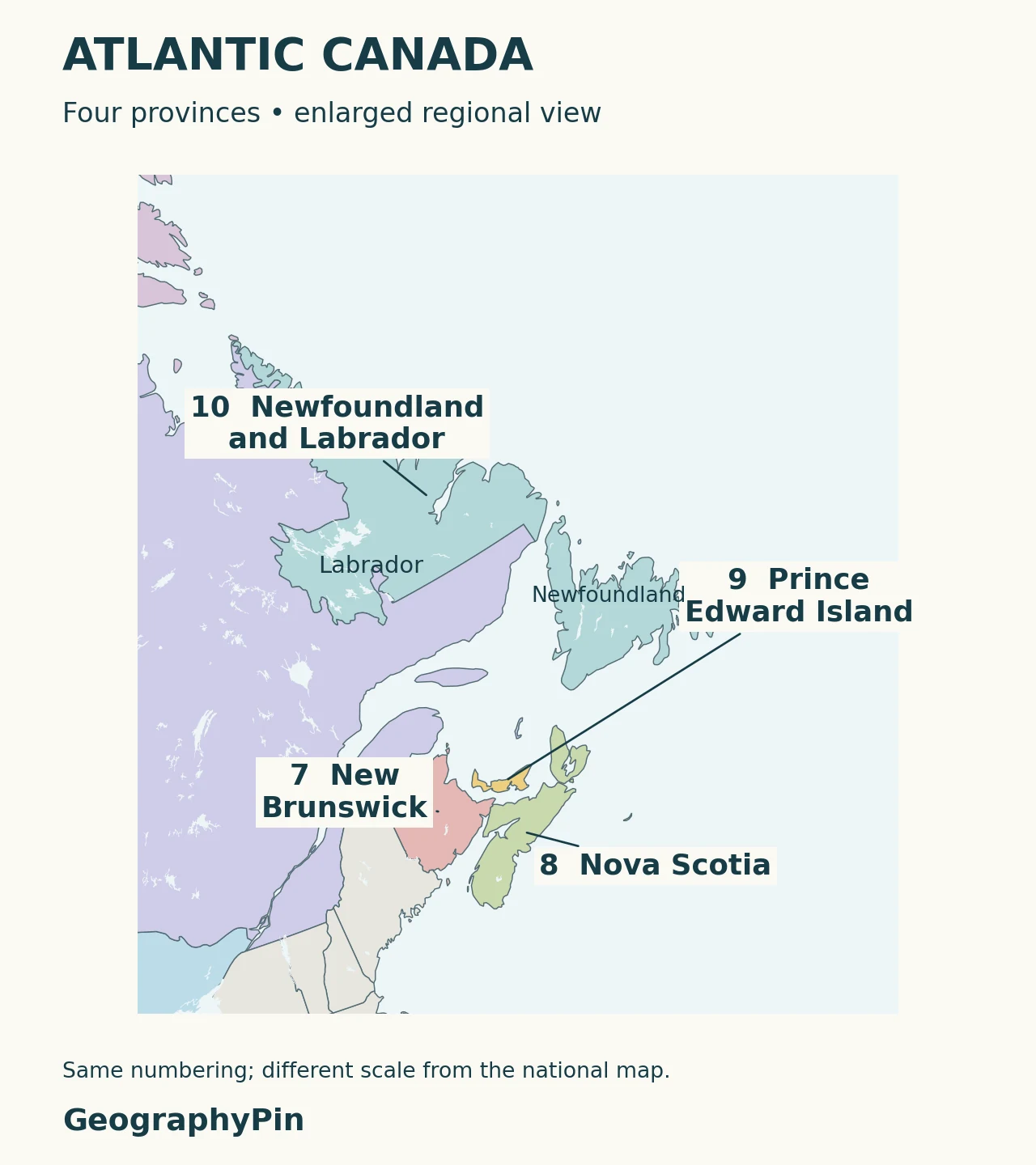
New Brunswick, Nova Scotia and Prince Edward Island are the three Maritime provinces. Add Newfoundland and Labrador to make the four Atlantic provinces. “Maritimes” and “Atlantic Canada” therefore do not refer to precisely the same group, as the Government of Prince Edward Island explains.
Prince Edward Island is easy to overlook on a national map, so the closeup uses a leader line rather than an oversized island symbol. Newfoundland and Labrador needs a different kind of care: a stretch of water separates its island and mainland portions, but they are not separate provinces. Trace the matching color before counting.
The regional sheet is enlarged independently. Compare positions and shapes within each sheet, not apparent sizes between the two images. These generalized maps are suitable for learning the provincial layout, not measuring a boundary, planning a route or locating a property.
Frequently asked questions
Does Canada have states?
Canada’s first-level divisions are called provinces and territories, not states. There are 10 provinces and 3 territories.
Are Newfoundland and Labrador two provinces?
No. Newfoundland and Labrador is one province. It includes the island of Newfoundland and the Labrador mainland portion shown in the same color.
Is Quebec a province or a city?
Quebec is the province; Québec City is its capital. The added word “City” helps distinguish the two in English.
What Did We Learn Today?
Canada’s map contains 10 provinces and 3 territories. Matching the map to a capital list prevents familiar-city mix-ups, while an Atlantic closeup makes the small provinces easier to find. Political status, capital cities and physical landforms are related, but they answer different questions.
Sources & Data Notes
- Government of Canada: Canada’s Regions, for the 13 capital pairs and regional orientation. Historical population figures on that page are not used here.
- Intergovernmental Affairs: Provinces and territories, for the constitutional distinction and devolution.
- Department of Justice: The Canadian Constitution, for the governance context and Indigenous rights and arrangements.
- Government of Prince Edward Island: Where is Prince Edward Island?, for Maritime and Atlantic membership.
- Natural Earth states and provinces and lake outlines, public-domain geographic data.
Map method: GeographyPin used Natural Earth’s 1:50 million provincial and territorial polygons, with 1:10 million lake shapes for water. Both sheets use a Canada-centered Lambert conformal conic projection. The 13 label anchors were checked inside their corresponding polygons. Atlantic callouts use leader lines; the closeup has a different scale. Boundaries are generalized and are not cadastral, treaty or navigation data. The colors and numbering are editorial aids, not official classifications.