Georgia, called Sakartvelo by Georgians, is a sovereign country in the South Caucasus on the eastern Black Sea. It is not the U.S. state of the same name: the country has Tbilisi as its capital, Georgian as its principal official language, and the lari as its currency.
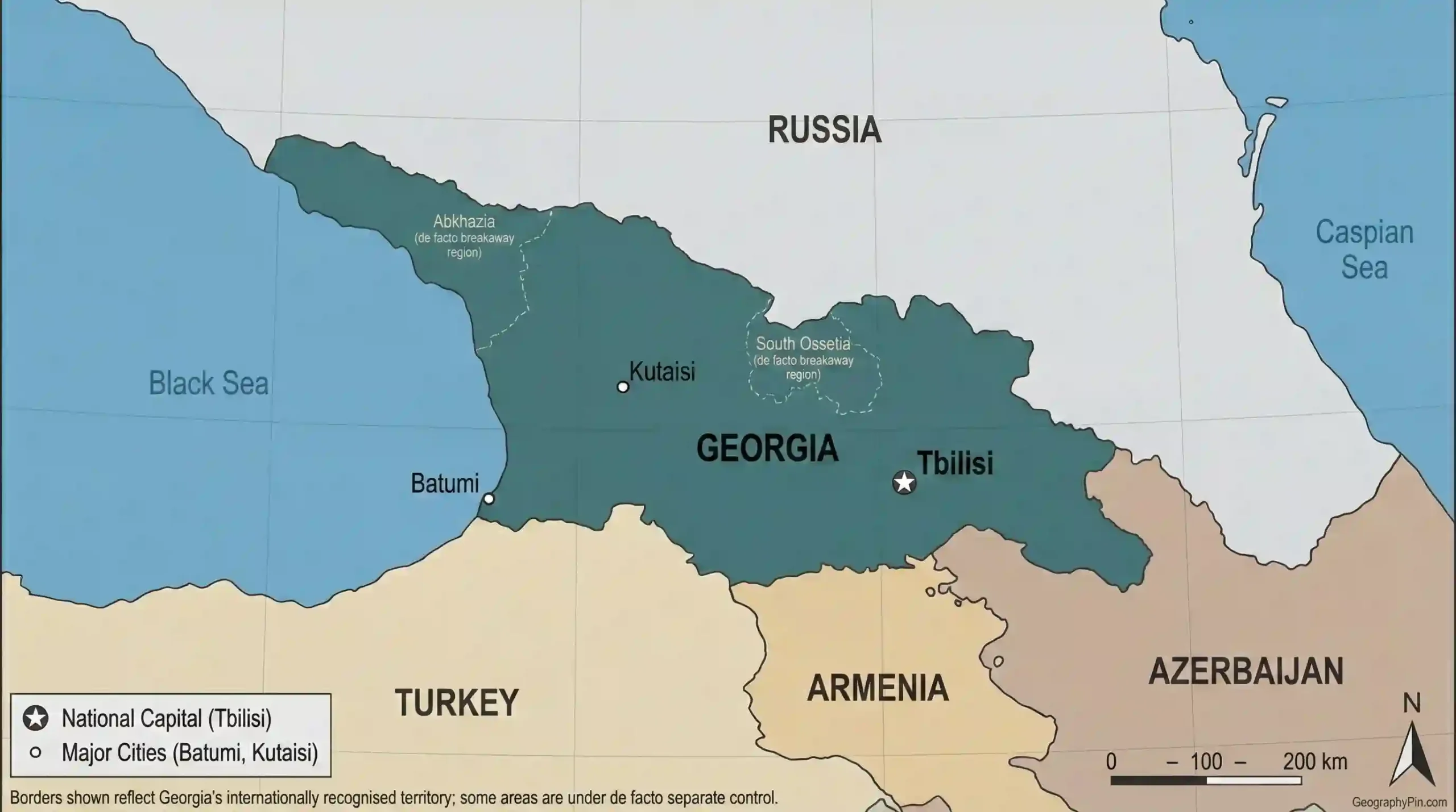
A Georgia country profile also needs a coverage note. The country’s internationally recognized area includes Abkhazia and Tskhinvali Region/South Ossetia, while Georgia’s latest census, population estimates, and most administrative and economic statistics exclude these territories because they are outside the Georgian government’s effective control.
Georgia, or Sakartvelo, is a South Caucasus country on the Black Sea, bordered by Russia, Turkey, Armenia, and Azerbaijan. Tbilisi is its capital. Its placement in Europe or Asia depends on the boundary convention, and its internationally recognized territory includes Abkhazia and South Ossetia, which Tbilisi does not effectively control.
How to use this article: Start with the dated country dashboard, check what each figure covers, read the territorial-status explanation, or go directly to the economic indicators.
Georgia at a Glance
Dated country dashboard
The dashboard separates fixed identifiers from changing statistics. Population figures come from Georgia’s national statistics office, Geostat; the reference date and territorial coverage are stated beside each value.
| Field | Verified fact |
|---|---|
| English state name | Georgia |
| Georgian name | Sakartvelo (საქართველო) |
| Capital and largest city | Tbilisi |
| Internationally recognized area | About 26,900 square miles (69,700 km²), including Abkhazia and Tskhinvali Region/South Ossetia |
| Latest population estimate | 3,941,100 on January 1, 2026; excludes territories outside the Georgian government’s effective control |
| Latest census count | 3,929,581 on November 14, 2024; same territorial exclusion |
| Official language | Georgian; the Constitution also gives Abkhaz official status in the Autonomous Republic of Abkhazia |
| Currency | Georgian lari (GEL, ₾), divided into 100 tetri |
| Time zone | UTC+4 year-round; no daylight-saving change |
| Government | Parliamentary republic with a 150-seat unicameral Parliament elected by proportional representation |
| Land neighbors | Russia, Turkey, Armenia, and Azerbaijan; the Black Sea is to the west |
| Regional position | South Caucasus; Europe–Asia classification depends on the convention used |
| ISO 3166 codes | GE (alpha-2), GEO (alpha-3), and 268 (numeric) |
Location and the Europe–Asia question
Georgia lies between the Greater Caucasus and the uplands south of the Mtkvari valley, with roughly 190 miles (310 kilometers) of Black Sea coast using the latest rounded Geostat figure. Russia is north, Turkey and Armenia are south, and Azerbaijan is east and southeast. This location places Georgia among the four countries commonly discussed in a broad Caucasus framework.
There is no single natural boundary between Europe and Asia accepted for every purpose. Under a common geographic convention that runs the continental boundary along the Greater Caucasus watershed, much or all of Georgia lies south of the line in Asia; political and cultural institutions often associate Georgia with Europe. The fuller answer is in Is Georgia in Europe or Asia?
What Georgia’s Numbers Include
The territorial coverage rule
Area and boundary figures describe Georgia within its internationally recognized borders. Census, population, economic, and most administrative series describe areas covered by Georgian statistical collection and normally exclude Abkhazia and Tskhinvali Region/South Ossetia. Keeping those scopes separate prevents a precise-looking but methodologically inconsistent result.
| Figure or dataset | Reference area | How to read it |
|---|---|---|
| 26,900 sq mi (69,700 km²) | Internationally recognized state territory | Includes Abkhazia and South Ossetia/Tskhinvali Region |
| 2024 final census | Areas enumerated by Geostat | Excludes both territories outside Tbilisi’s effective control |
| 2026 population estimate | Post-census Geostat estimate for covered areas | Uses the same territorial exclusion |
| Ethnicity, language, and religion shares | Residents enumerated in the 2024 census | Not a demographic profile of the excluded territories |
| Most national economic series | Economy measured by Georgian statistical institutions | Should not be treated as direct data for areas outside government control |
This profile therefore does not calculate one national population-density figure by dividing the government-covered population by the larger internationally recognized area. Either a matched-area denominator or an explicit mixed-scope label would be needed.
Final census versus annual estimate
Geostat’s final census counted 3,929,581 usual residents at the reference moment of midnight on November 13–14, 2024. This final figure, released in June 2026, replaces the preliminary total of about 3.914 million.
The 3,941,100 figure is an annual estimate for January 1, 2026, not a second census. Geostat’s series was rebased after the 2024 enumeration, so the break between the older pre-census series and the revised 2025 series should not be read as a sudden one-year population surge.
Land, Rivers, Climate, and Natural Hazards
Mountains, lowlands, and the west–east divide
Roughly two-thirds of Georgia is mountainous. The Greater Caucasus forms the high northern arc, where glaciated peaks rise above 16,000 feet (4,900 meters). Shkhara is generally identified as Georgia’s highest summit, although published elevations differ because sources have not always measured or identified the same summit point.
In the south, the Lesser Caucasus and the volcanic Javakheti uplands create a second belt of high country. Between them lie valleys and basins that hold much of the population. The Likhi, or Surami, Range divides western and eastern Georgia and is both a watershed and a major climatic barrier.
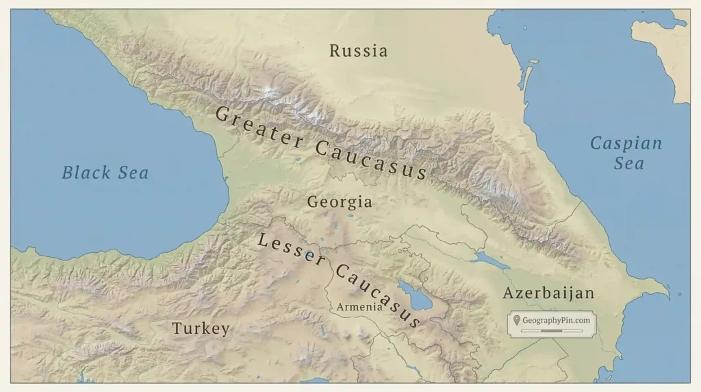
West of the Likhi Range, the Kolkheti Lowland forms a humid alluvial plain between the mountains and Black Sea. Its wetlands and Colchic forests contrast sharply with the drier valleys and plateaus of eastern Georgia.
Two drainage directions
Western Georgia’s rivers drain to the Black Sea. The Rioni, the country’s most voluminous river, crosses the Kolkheti Lowland before reaching the coast near Poti.
Most of eastern Georgia drains through the Mtkvari, known internationally and downstream as the Kura. It flows from Turkey through Tbilisi and into Azerbaijan before reaching the Caspian Sea. The two-name convention and conflicting published total lengths are explained in Mtkvari or Kura?
Climate zones and natural hazards
The western lowlands and Black Sea coast have a humid subtropical climate influenced by maritime air. Eastern valleys are drier and more continental, while elevation produces cool mountain, alpine, and permanent-snow conditions over short distances. The Caucasus ranges and the Likhi divide help create these strong local contrasts.
Georgia’s relief, geology, and climate also create recurring natural hazards:
- earthquakes;
- river floods and flash floods;
- landslides, rockfalls, and mudflows;
- snow avalanches;
- severe storms, high winds, and hail; and
- drought and wildfire risk, especially in parts of eastern Georgia.
Glacier retreat adds a longer-term water and slope-stability concern in the high Caucasus. Risk varies sharply by valley and elevation, so a national list should not be read as a local forecast.
Population, Languages, and Religion
Population and settlement pattern
The final 2024 census recorded 3,929,581 residents in the territory it covered, 5.8% more than the comparable 2014 count. Urban settlements held 2,455,444 people, or 62.5%, while 1,474,137 people, or 37.5%, lived in rural settlements.
Growth was geographically concentrated. Tbilisi reached 1,331,485 residents and accounted for about one-third of the census total. Adjara also grew strongly, led by Batumi, while most other regions declined; rural population fell 7.4% from 2014. People aged 65 and older made up 17.6%, showing that aging is an important part of the demographic picture.
Georgian language and script
Georgian is a Kartvelian language, a family distinct from Indo-European, Turkic, and Semitic language families. Modern Georgian is normally written in the rounded Mkhedruli script. In the 2024 census-covered area, 85.1% of residents reported Georgian as their mother tongue, 6.8% Azerbaijani, and 3.5% Armenian.
The Constitution makes Georgian the official language nationwide and also names Abkhazian as official within the Autonomous Republic of Abkhazia. That constitutional status should not be confused with the languages most commonly used in every locality.
Ethnicity and religion in the final 2024 census
Within the enumerated population, 84.1% identified as ethnic Georgian, 6.8% as Azerbaijani, and 4.3% as Armenian. Smaller groups included Russians, Indians, Ukrainians, Arabs, Ossetians, Yazidis, and others. These figures describe residents of the census-covered area, not the population living in Abkhazia or South Ossetia.
On religion, 82.0% identified as Orthodox Christian and 11.1% as Muslim; the Armenian Apostolic community was another significant group. Census identity categories are self-reported and describe affiliation, not personal observance.
Government, Administration, and Territorial Control
Political, recognition, and EU-status evidence checked: August 15, 2026.
A parliamentary republic
Georgia’s Constitution defines it as a democratic republic. In the present parliamentary system, the government is the supreme executive body and the prime minister heads it and is accountable to Parliament. The president is head of state and has a more limited constitutional role.
The unicameral Parliament has 150 members elected for four-year terms. Under the current constitutional and electoral model, parliamentary seats are filled through a nationwide proportional system rather than the older mixed district-and-party-list model.
Regions, autonomous republics, and municipalities
A common top-level description lists nine regions, the autonomous republics of Adjara and Abkhazia, and Tbilisi with separate capital status. The nine regions are state administrative units headed by appointed representatives, not elected regional governments. Local self-government operates through cities and community municipalities.
This structure also requires a territorial qualifier: Adjara functions under the Georgian constitutional system, while Abkhazia is an autonomous republic in Georgian law but is outside Tbilisi’s effective control. Administrative counts can therefore differ depending on whether a source describes de jure territory or operating institutions.
Internationally recognized territory versus effective control
De jure status: Abkhazia and Tskhinvali Region/South Ossetia lie within Georgia’s internationally recognized borders. Georgia claims sovereignty over both, and the United Nations, European Union, and Council of Europe support Georgia’s territorial integrity.
De facto control: The Georgian government does not administer either territory. Each has de facto authorities that claim independent statehood, while Russia maintains military forces and extensive political and economic support. The European Court of Human Rights has found continuing Russian effective control in the relevant legal context.
As of the evidence date, four UN member states recognize both territories as independent: Russia, Nicaragua, Venezuela, and Syria. Nauru withdrew its recognition on July 30, 2026. The legal status, recognition, and actual control should therefore be described separately rather than collapsed into one label.
For place-specific detail, see the neutral profiles of Abkhazia and South Ossetia.
International alignment
Georgia’s Constitution directs state bodies to take measures toward full integration into the European Union and NATO. Georgia is not a member of either organization.
The EU granted Georgia candidate status in December 2023. It formally remained a candidate on August 15, 2026, but accession negotiations had not opened and the process was effectively at a standstill following the European Council’s 2024 conclusions and the Georgian government’s announced suspension of the process until 2028. Georgia also participates in the EU’s Eastern Partnership and has an Association Agreement and free-trade framework with the EU.
Economy, Trade, and Transit
Selected economic indicators
The figures below use the latest complete annual data available at the August 2026 check. Each row identifies its year and method so that nominal GDP, unemployment, tourism, trade, money transfers, and human development are not treated as interchangeable measures.
| Indicator | Value and year | Method or source note |
|---|---|---|
| Nominal GDP | $38.14 billion, 2025 | World Bank current-U.S.-dollar series; not purchasing-power parity |
| Nominal GDP per person | $9,691.5, 2025 | World Bank current-U.S.-dollar series using its own population series |
| Real GDP growth | 7.5%, 2025 | World Bank annual series |
| Unemployment | 13.9%, 2025 | Geostat annual labor-force measure |
| Merchandise exports and imports | $7.29 billion exports; $18.65 billion imports, 2025 | Geostat; exports include re-exports, imports reported CIF |
| International travel receipts | $4.69 billion, 2025 | Tourism administration; receipts are not a GDP-contribution estimate |
| Money transfers received | $3.65 billion, 2025 | National Bank transfer inflows; narrower than some balance-of-payments remittance concepts |
| Human Development Index | 0.844; rank 57 of 193 | UNDP, 2023 data published in the 2025 report; “very high human development” category |
The first three rows use one World Bank series so the GDP total and per-person figure share a method. Separately, Geostat’s preliminary 2025 national accounts put GDP at GEL 104.6 billion ($38.14 billion), but its 2025 per-capita figure had not yet been revised to the final census base at the evidence date. This profile does not recompute GDP per person from the census.
Services, tourism, trade, and agriculture
Services produce most economic activity. Wholesale and retail trade is a large component, alongside real estate, transport and storage, finance, information and communications, public services, and hospitality. Tourism is important as a source of service exports: Georgia recorded about 5.52 million overnight international tourist trips in 2025, a count of trips rather than unique people.
Merchandise imports substantially exceeded exports in 2025. Re-exported motor vehicles form an important part of reported exports, which is why domestic exports and total exports answer different questions. Wine, mineral water, metals, agricultural products, and manufactured goods also contribute to outward trade.
Agriculture, forestry, and fishing accounted for about 5.9% of preliminary 2025 GDP, but their role in rural livelihoods is larger than that share alone suggests. Grapes and wine, hazelnuts, citrus fruit, other fruit and vegetables, and livestock are among the recognizable activities, with strong regional specialization.
Black Sea and overland transit
Georgia sits on transport and energy corridors between the Caspian basin, the Black Sea, and Turkey. The ports of Poti and Batumi, east–west highways, the Baku–Tbilisi–Kars railway, and oil and gas pipelines support freight, energy transit, and regional trade. This location creates opportunity, but it also leaves the economy exposed to external demand, regional disruptions, and changes in transit routes.
Cities and Regions
Tbilisi, Batumi, and Kutaisi
Tbilisi is Georgia’s capital, largest city, and principal political, business, university, and transport center. It lies on the Mtkvari in eastern Georgia and had 1,331,485 residents in the final 2024 census.
Batumi, on the Black Sea in Adjara, is the principal city of the southwest and an important port, tourism, and service center. Its census population reached 235,668 in 2024. Kutaisi, on the Rioni in Imereti, is western Georgia’s major inland city and a long-standing industrial, educational, and transport center.
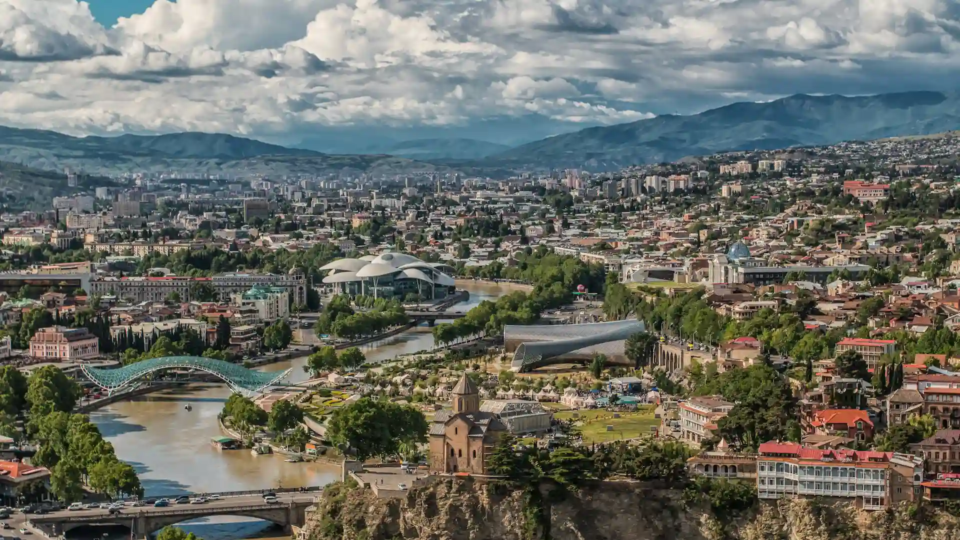
For a broader settlement hierarchy without turning this profile into a city-by-city guide, use the guide to cities in the country of Georgia.
A practical regional orientation
Western Georgia includes the Black Sea-linked regions of Adjara, Guria, and Samegrelo-Zemo Svaneti; Imereti centers on Kutaisi; and Racha-Lechkhumi and Kvemo Svaneti extend into sparsely settled mountain country. The west is generally wetter, greener, and more closely tied to the Rioni and other Black Sea drainage systems.
Eastern and southern Georgia include Kakheti, known for agriculture and wine production; Kvemo Kartli, a populous and ethnically varied southeastern region; Mtskheta-Mtianeti along northern mountain routes; Shida Kartli in the central interior; and the highland region of Samtskhe-Javakheti. These broad labels help locate the regions, but they do not erase large differences within each one.
Georgia’s History in a Geographic Timeline
Georgia’s present borders and political geography make more sense when ancient western and eastern kingdoms, medieval unification, imperial annexation, Soviet rule, and the post-Soviet conflicts are kept in sequence.
| Period | Geographic and political development |
|---|---|
| First millennium BCE–classical antiquity | Colchis developed in western Georgia and Iberia, or Kartli, in the east; both are central to the history of Georgian statehood. |
| Early 4th century | Iberia adopted Christianity, shaping the later Georgian monarchy and written culture. |
| Around 1008–early 13th century | Bagrat III brought major Georgian realms under one crown; the kingdom later reached its medieval high point under David IV and Queen Tamar. |
| 13th–18th centuries | Mongol invasions, later regional empires, and internal division weakened unity and produced separate kingdoms and principalities. |
| 1801–19th century | The Russian Empire annexed Kartli-Kakheti in 1801 and absorbed other Georgian polities in stages. |
| 1918–1921 | The Democratic Republic of Georgia declared independence on May 26, 1918; the Red Army invasion in February 1921 ended the first republic. |
| 1921–1991 | Georgia was incorporated into the Soviet system, first within a Transcaucasian federation and later as a Soviet republic. |
| 1991–1993 | Georgia restored independence on April 9, 1991. Wars in South Ossetia and Abkhazia caused mass displacement and left both outside Tbilisi’s control. |
| 2003 | The Rose Revolution brought a change of government and accelerated state reforms and Western-oriented policy. |
| August 2008 | The Russia–Georgia war followed years of unresolved conflict and escalating incidents; Russia then recognized Abkhazia and South Ossetia as independent. |
| 2023–2024 | Georgia received EU candidate status in 2023, but the accession process was de facto halted in 2024. |
Frequently Asked Questions
Why is Georgia called Sakartvelo?
Sakartvelo is the country’s name in Georgian; Georgia is its common English name. They refer to the same modern state, not to two different countries.
Does Georgia change its clocks for daylight saving time?
No. Georgia uses UTC+4 throughout the year, under the IANA time-zone identifier Asia/Tbilisi.
Does Georgian use the Cyrillic alphabet?
No. Georgian has its own writing tradition; modern everyday Georgian is written in the Mkhedruli script.
Is Georgia a member of the European Union or NATO?
No. Georgia is formally an EU candidate, although accession was effectively at a standstill at the evidence date, and it cooperates closely with NATO without being a member.
What Did We Learn Today?
Georgia is a South Caucasus country whose Black Sea coast, Caucasus mountains, east–west river divide, concentrated urban growth, distinct language, parliamentary system, and transit economy can be understood only with one territorial rule kept in view: its internationally recognized area includes Abkhazia and South Ossetia, but most current Georgian statistics exclude both because they are outside Tbilisi’s effective control.
Sources & Data Notes
Data and status were checked August 15, 2026. Geostat’s final 2024 census and its post-census population estimate exclude Abkhazia and Tskhinvali Region/South Ossetia, while the rounded 26,900-square-mile (69,700-km²) area covers Georgia within its internationally recognized borders. Economic indicators retain their source-specific methods and years; nominal figures are not PPP values, trip counts are not unique visitors, and no GDP-per-person figure was recomputed from the census. Coastline and summit measurements are rounded because published methods and identified summit points vary.