Tbilisi is the capital of Georgia (the country), not the U.S. state with the same name. It’s a river-valley city in the Caucasus where geography, history, and regional politics meet in one urban spine.
If you want the fast version: learn what “Tbilisi” means on the map, where it sits, and why that location keeps pulling power, people, and routes into the same place.
Tbilisi is the capital of Georgia (the country) and its main seat of government, set in eastern Georgia along the Mtkvari (Kura) River. Its position in a narrow valley makes it both a natural crossroads and a city shaped by terrain, bridges, and chokepoints—one reason it has remained Georgia’s central political and economic hub for centuries (Constitution of Georgia, 2017).
How to use this article: If you just need the answer, hit the fast check. If you’re sorting out what people mean by “Tbilisi,” go to the definition table. If you care about the real stakes of location, jump to why geopolitics sticks to this city. For quick clarifications, the FAQ is built for that.
Fast facts: what makes Tbilisi the capital?
Tbilisi is Georgia’s capital in both practice and law: it’s where national political life, most central institutions, and the country’s diplomatic presence cluster (Constitution of Georgia, 2017). That concentration isn’t just tradition—it’s also geography: the city sits where routes, valleys, and river crossings naturally funnel movement.
In Georgian script, the city is written as თბილისი. In everyday speech you’ll also hear “Tbilisi” used in three different ways: the historic core (Old Tbilisi), the self-governing city/municipality, and the wider urban region people commute across. Those are not the same thing, and the difference matters when you read statistics or maps.
Fast check: how to recognize “capital functions” on the ground
If a city is functioning as a capital, you’ll usually see three markers at once: (1) top-level government institutions and national ministries, (2) embassies and foreign missions, and (3) the main media, finance, and higher-education concentration. Tbilisi checks all three, which is why it stays the country’s command center even as other cities specialize in industry, ports, or tourism.
What “Tbilisi” means in common map language
| Meaning | What it usually refers to | Why you should care |
|---|---|---|
| Old Tbilisi | The historic riverbank neighborhoods, fortress zone, and sulfur-bath area. | This is the mental “postcard” city—most history and signature architecture concentrates here. |
| Tbilisi (municipality/city) | The self-governed city unit with municipal services, planning, and elected local leadership. | Most “official city” statistics and budgets attach to this definition (GeoStat tables often separate cities/units). |
| Greater Tbilisi (metro area) | The wider commuting belt and connected settlements beyond the central city. | Transport, housing pressure, and labor markets make sense at this scale, but counts vary by definition. |
One more detail that often surprises first-time readers: the name “Tbilisi” is commonly linked to the Georgian word tbili (“warm”), tied to the hot springs under the city and the sulfur-bath district (Georgia Travel, 2024). Whether you treat the founding legend as myth or memory, the geography is real: warm water and a defendable river corridor shaped the first settlement logic.
Where Tbilisi sits on the map
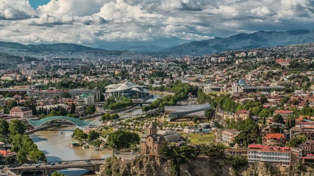
Tbilisi lies in eastern Georgia, in a narrow valley and gorge setting where the Mtkvari (Kura) River cuts between ranges. That simple fact explains a lot: the city grows along the river, bridges become strategic connectors, and steep slopes create distinct “upper” and “lower” neighborhoods rather than one flat grid (Britannica, 2025).
Zoom out, and the logic becomes regional. Georgia’s population and transport routes concentrate in corridors where mountain barriers ease into valleys. Tbilisi sits in that kind of corridor—close enough to the Greater Caucasus–Lesser Caucasus divide that it acts as a practical organizing point for roads, rail, and national administration.
Why the river valley matters more than you think
River valleys do three jobs at once: they provide water access, they create buildable (or at least buildable-enough) strips in rough terrain, and they mark routes. Tbilisi’s core forms along the Mtkvari, so the city’s daily geography is about crossing points, riverbank roads, and slope-to-valley transitions.
This also shapes visibility and control. High ground around a river city offers observation and defense; low ground offers movement and commerce. That pattern is old, and it still influences where landmarks sit and how people move through the center.
Tbilisi vs “Georgia” confusion
Internationally, “Georgia” can mean either the country in the Caucasus or the U.S. state. When the context includes Tbilisi, the Caucasus, the Mtkvari/Kura, or neighboring Armenia/Azerbaijan, it’s the country. That’s the meaning here.
City layout: districts, landmarks, and everyday orientation
Tbilisi reads best as a “river city plus ridgelines.” The historic center hugs the Mtkvari, while newer districts spread onto broader ground where slopes relax. If you’re trying to orient yourself quickly, start with the river: it’s the city’s main reference line, and major crossings tell you where movement concentrates.
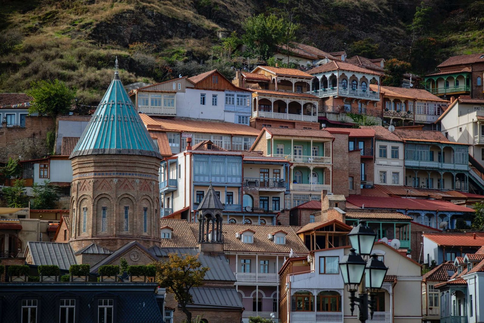
Old Tbilisi: the signature core
Old Tbilisi is the zone of balconies, tight streets, and the visual layering of eras—medieval fortification lines above, older neighborhoods below, and modern city life stitched through it all. The sulfur-bath district (Abanotubani) is part of this historic logic: hot springs, dense building fabric, and a distinct “low basin” feel where the city’s origin stories concentrate.
The modern spine: where institutions and daily life meet
Most capital-city routines—administration, business meetings, major cultural venues—gravitate toward a central spine rather than spreading evenly. In Tbilisi, that spine runs through the inner city where the widest streets, major squares, and flagship public buildings cluster, with public transport pulling people back into the same corridor.
The result is a city that feels like several places at once: a historic riverbank core, a modern administrative-commercial center, and residential districts that climb or spread outward. That geography is why neighborhoods can feel very different even at short distance.
A practical mental map (no street-level obsession)
- River = orientation line: If you know which bank you’re on and where the nearest bridge is, you can re-center fast.
- Slopes = neighborhood boundaries: Hills and terraces often mark where one district “ends” in feel, even if the map doesn’t show a hard border.
- Ridges = viewpoints and routes: Overlooks tend to sit on high ground; so do some of the city’s most direct cross-city connections.
A short timeline of Tbilisi
Tbilisi’s timeline is best understood as “capital logic plus corridor logic.” When empires compete for routes across the Caucasus, the prize is not only territory—it’s the nodes that control movement, taxation, and administration. Tbilisi sits in exactly that kind of node.
Origins and early capital role (dates vary by source)
Britannica places the city’s founding in the mid-5th century and links it to the transfer of a Georgian kingdom’s capital from nearby Mtskheta, noting 458 (with some sources giving 455) (Britannica, 2025). Other references place the capital shift later, in the early 6th century (CIA World Factbook, 2026). The safe takeaway is the geography: Tbilisi’s river corridor and defensible terrain made it a durable center once power moved there.
Imperial layers: why the city carries so many styles
Tbilisi has repeatedly absorbed outside influence—political, architectural, and demographic—because it sits on a route that connects regions rather than isolating them. That doesn’t mean the city is “a museum”; it means the built environment often preserves older layers next to newer ones, sometimes on the same street.
Soviet period to independence: infrastructure still visible
Modern public transport is one clear marker of the Soviet-era imprint. The Tbilisi Metro began operating in 1966, and the system’s deep-station design reflects the engineering priorities of that time (Tbilisi Transport Company, 2026). You don’t need to be a transport nerd to feel the impact—metro lines and station nodes shape where the city densifies and how commuters flow.
Government, institutions, and why the capital concentrates power
Being a capital is not only a title; it’s a system of gravity. National institutions cluster because proximity reduces friction: meetings, oversight, security coordination, and diplomacy all work faster when the core actors are in the same city.
At the city level, Tbilisi has its own municipal governance structure, including a city assembly (Sakrebulo) and an executive branch (City Hall/Mayor’s office). Municipal budgets, urban planning decisions, and service delivery flow through that local layer—separate from national government, but constantly interacting with it (Tbilisi City Municipal Assembly, 2026).
Capital effects you can see
- Jobs and education concentrate: administration, universities, and professional services stack in the capital first.
- Media and agenda-setting: national politics becomes “local news” in the capital, because decision-makers are nearby.
- Real estate pressure: when opportunity concentrates, housing markets respond—often faster than infrastructure can.
Why some functions never fully decentralize
Even if parts of a state try to distribute agencies across multiple cities, capitals tend to re-collect influence over time. The reason is basic: diplomacy, crisis management, and high-level coordination prefer proximity. In a mountainous country with corridor-style transport geography, that pull can be even stronger.
Economy and connectivity: roads, rail, air, and digital links
Tbilisi’s economic role is tightly linked to connectivity. The city sits on the country’s most important internal routes and also connects outward—west toward the Black Sea ports, south toward Armenia, and southeast toward Azerbaijan. In practice, that makes Tbilisi a coordination point for trade, logistics, and services, even when the physical goods move through other nodes.
Public transport as “city geometry”
Metro and bus networks don’t just move people; they shape where the city becomes denser, where rents rise, and where new commercial streets appear. Tbilisi’s metro has operated since 1966, and its station nodes are still some of the most reliable anchors for navigating the city quickly (Tbilisi Transport Company, 2026).
Air, rail, and the reality of borders
For many countries, capital airports are a tourism detail. For Georgia, they’re also a geopolitical detail: flight routes, transit options, and regional connectivity can shift with diplomacy, sanctions, or security conditions. The safest way to treat “connectivity” is as a living system: it’s strong when politics is stable and weakens when the region tightens.
Reading the data without getting trapped by definitions
When people argue about how big Tbilisi is, they’re often arguing about boundaries, not headcounts. Official tables commonly separate population by regions, self-governed units, and cities, and those categories do not always match what commuters think of as “the city” (GeoStat, latest tables). Treat comparisons cautiously unless the definition is stated.
Why Tbilisi’s location matters geopolitically
Tbilisi is a capital in a region where geography keeps politics close to the ground. The Caucasus is not a flat chessboard; it’s a landscape of barriers and corridors. That means state strategy often comes down to controlling movement: roads through valleys, rail links, border crossings, and the urban nodes that manage them.
The capital as a corridor manager
Georgia sits between larger regional powers and along routes that connect the Black Sea basin to the South Caucasus and beyond. Tbilisi’s role is partly to manage that corridor reality—diplomacy, customs policy, infrastructure planning, and security coordination tend to centralize where the state can act fastest.
Why “nearby conflicts” still reshape capital decisions
In the South Caucasus, shifts in Armenia–Azerbaijan relations, Russia’s posture in the region, and broader East–West tensions can all affect Georgia’s options. Capitals respond first because they host foreign missions, national command systems, and the policy machinery that adjusts to risk.
Urban geopolitics: what this looks like in a city
- Diplomatic density: embassies and international offices make the capital the country’s “external interface.”
- Information flows: major media and political debate concentrate where institutions are closest.
- Infrastructure priorities: when budgets are tight, capitals often get “first upgrades” because national performance is judged there.
Practical travel notes and local etiquette
Tbilisi is walkable in parts, but the slopes are real. Expect elevation changes and short, steep streets—comfortable shoes matter more than “distance on paper.” If you’re moving across the city, public transport and ride-hailing can save time, especially when the river-crossings and bridge approaches get busy.
Timing your visit with geography in mind
In river-valley cities, weather can feel “local”: one neighborhood can be breezy while another is sheltered and warmer. Plan your day like a local does—morning for climbs and viewpoints, later for the lower-city streets and cafés, and evenings for the riverbank atmosphere when temperatures settle.
Cultural basics that help you blend in
- Language: Georgian is the main language; learning a simple hello/thank you goes a long way.
- Religious sites: dress modestly in churches and be respectful around services and icons.
- Food culture: meals can be social and generous; pace yourself and accept that hospitality is part of the local “system.”
One smart habit: verify “admin hours” locally
Because the capital hosts many institutions, visitors sometimes plan around offices, museums, or municipal services. Schedules can change with holidays and events. If timing matters, confirm close to the day—especially in winter holiday periods.
FAQ
Is Tbilisi the capital of Georgia the country?
Yes. Tbilisi is Georgia’s capital in law and in practice, and it’s where most national decision-making and diplomacy concentrates (Constitution of Georgia, 2017).
What river runs through Tbilisi?
The Mtkvari River—also known internationally as the Kura—runs through the city and shapes its core layout and bridge crossings (Britannica, 2025).
Why do some sources disagree on Tbilisi’s founding or “capital transfer” date?
Early medieval timelines can vary by chronicle tradition and how a source defines “founded” versus “made capital.” Reliable references agree on the broader picture—Tbilisi became a key political center in late antiquity/early medieval Georgia—even if exact years differ (Britannica, 2025; CIA World Factbook, 2026).
How should I think about “Tbilisi population” numbers?
First ask: city proper, self-governing unit, or metro area? Official statistical tables often separate these categories, and comparisons can be misleading if two sources use different boundaries (GeoStat, latest tables).
Is Tbilisi in Europe or Asia?
Georgia sits in the Caucasus at the edge of both European and West Asian geographic framings, and different institutions draw the “Europe–Asia” boundary differently. In practice, Tbilisi is best described as a Caucasus capital—culturally and politically connected to Europe, while geographically anchored in a classic mountain-corridor region.
What’s the fastest way to understand Tbilisi as a visitor?
Use the river as your compass, spend time in Old Tbilisi for the historic logic, then ride public transport once to feel the city’s commuting spine. You’ll understand the city’s geography faster than by chasing a long checklist of sights.
What Did We Learn Today?
- Tbilisi isn’t “just the biggest city” — it’s the capital in the legal sense and in the everyday sense, so politics, media, and money naturally pile up here.
- The Mtkvari (Kura) is the city’s backbone — once you see Tbilisi as a river-and-slopes city, the bridges, neighborhoods, and traffic logic start making sense.
- “Tbilisi” changes meaning depending on the context — Old Tbilisi, the municipality, and the wider commuter belt are different things, and statistics only work when you know which one a source is using.
- Location is the quiet engine — a capital sitting in a Caucasus corridor ends up managing routes, chokepoints, and regional pressure whether it wants to or not.
Sources & Data Notes
Tbilisi is one of those topics where people “know” the city, but the numbers and dates can still trick you. For capital status and official wording, I lean on Georgia’s constitution and other state-level legal texts. For population, admin boundaries, and what counts as “the city,” I stick to GeoStat-style tables because “Tbilisi city” and “greater Tbilisi” are not the same thing on paper. For the physical geography (river, valley/gorge setting, relief), I use standard geographic references rather than travel copy. And for early-history dates, I treat disagreements as normal: if credible sources don’t match, I don’t force one perfect year—better a clean range or cautious phrasing than fake precision. Any figures mentioned should be read as “latest available from the stated source,” with rounding kept honest and definitions stated clearly.