Many readers meet this river under two different names and assume they are looking at two different waterways. They are not. The confusion comes from language, mapping habits, and the fact that this is one of the major cross-border rivers of the South Caucasus.
Mtkvari and Kura are the same river. Mtkvari is the Georgian name, while Kura is the form more commonly used in English-language reference works and in several neighboring naming traditions. The river rises in northeastern Turkey, crosses Georgia and Azerbaijan, receives the Aras, and empties into the Caspian Sea.
How to use this article: If you only need the quick answer, start with the fast check; for the naming rule, jump to which name belongs where; for geography, go to the river’s route; and for conflicting map numbers, head straight to why figures vary.
One river, several names
Fast check
If you see Mtkvari on a Georgian map and Kura in an English atlas, you are still looking at the same river. Britannica lists the waterway as the Kura and identifies Mtkvari as the Georgian form, while Georgian state institutions consistently write the name as Mtkvari.
| Name | Used mainly in | What it tells you |
|---|---|---|
| Kura | English-language and wider regional reference usage | The most common broad geographic label outside Georgia |
| Mtkvari | Georgian usage | The local Georgian river name |
| Kür | Azerbaijani usage | Another regional form for the same river |
| Cyrus | Ancient Greek and Latin references | A historical classical name you may see in older texts |
That spread of names is normal for a river that crosses several language zones and has been described for centuries in Georgian, Armenian, Azerbaijani, Persian, Greek, Latin, and modern European reference traditions.
Which name belongs where?
A practical reading of current usage is simple: Georgian domestic sources overwhelmingly use Mtkvari, while English-language general references more often use Kura. That is why the river in Tbilisi is usually called the Mtkvari in local context, but a basin map covering Turkey, Georgia, Azerbaijan, Armenia, and Iran may label the wider system as Kura-Aras or Kura-Araks.
Where the river actually flows
The river’s route
The river rises in northeastern Turkey, then moves into Georgia, where it passes through the country’s better-known historic corridor before continuing into Azerbaijan. Farther east, it meets its largest tributary, the Aras, and the combined system ultimately reaches the Caspian Sea. Regional basin references commonly describe that full transboundary path as one of the defining water systems of the South Caucasus.
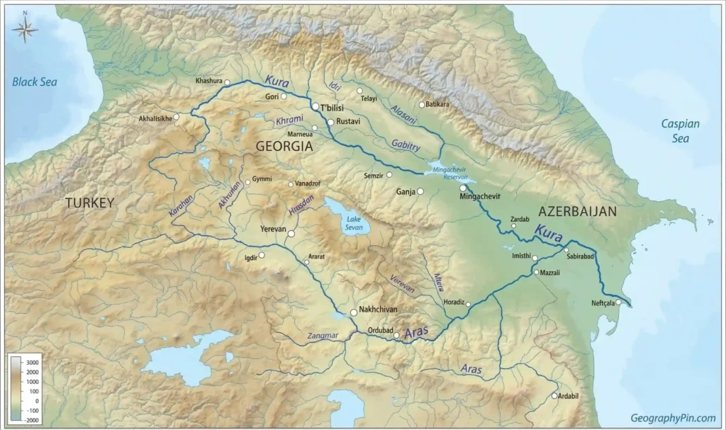
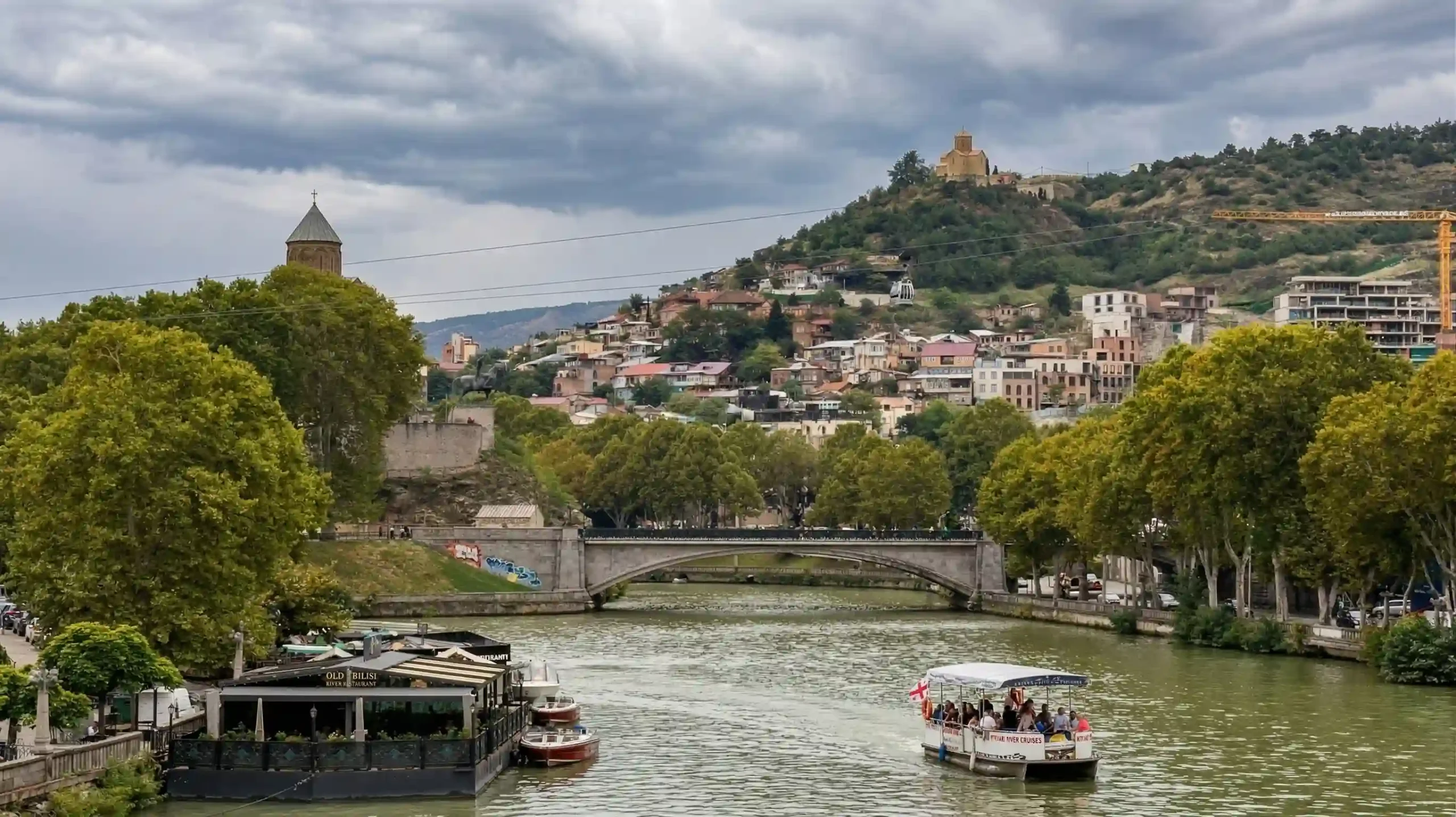
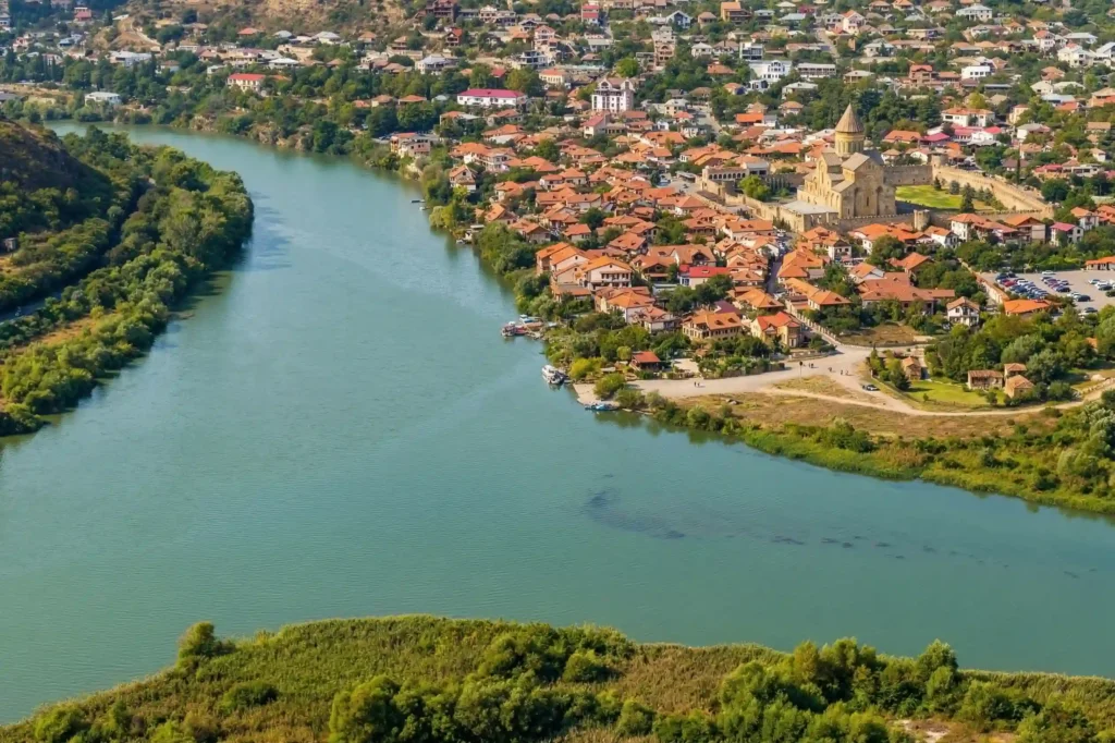
Inside Georgia, the river is tied to places that many readers already know by name. Official Georgian tourism material places the river near Vardzia, and historical material on Jvari Monastery identifies the famous confluence of the Mtkvari and Aragvi at Mtskheta. Iranica also notes the river’s course through Tbilisi, which helps explain why the Mtkvari sits so centrally in Georgian historical geography.
So the clean mental map is this: source in Turkey, major Georgian stretch, Azerbaijani lower course, Aras confluence, Caspian outlet. Once that route is clear, the naming issue becomes much less confusing, because the river is not changing identity as it moves east; only the language around it changes.
Why the figures do not always match
Why figures vary
This is one of the first things careful readers notice: reputable sources do not always give exactly the same number. Georgian environmental authorities and EUWI+East use a total length of 941 miles (1,515 kilometers), while Britannica gives 848 miles (1,364 kilometers). That means the safest editorial move is not to force a fake certainty, but to acknowledge the disagreement and explain it.
The same problem appears with basin size. Georgian state material gives 72,587 square miles (188,000 square kilometers) for the river basin, while EUWI+East gives 76,564 square miles (198,300 square kilometers) for the Kura-Aras basin frame. Those are not necessarily contradictory claims, because one source may be speaking about the Kura basin more narrowly, while another is treating the wider Kura-Aras transboundary system as the working hydrological unit.
For readers and writers, the practical rule is this: when you see different numbers, first check whether the source means the river alone or the larger basin system, and second check whether it is using a domestic Georgian frame or a broader regional water-management frame. Most of the apparent contradiction disappears once those two questions are asked.
Why the river matters in Georgia and beyond
For Georgia, the Mtkvari is not just a line on a map. Georgian environmental institutions describe it as the country’s main river, and official sector material notes that only about 249 miles (400 kilometers) of its course lies within Georgia even though that middle stretch carries major weight for settlement, transport, environment, and national historical memory.
That importance is especially visible around Mtskheta and Tbilisi. Iranica describes Mtskheta as strategically placed at the confluence of the Kura and Aragvi, while Tbilisi developed on both sides of the river. In other words, this river is not background scenery in Georgian history; it is part of the structure of the country’s core historical landscape.
Beyond Georgia, the river matters because it is part of a larger cross-border water system. EUWI+East and FAO frame the basin as a transboundary unit linking not just Turkey, Georgia, and Azerbaijan, but also the wider Kura-Aras hydrological space that reaches into Armenia and Iran. That broader framing is one reason the name Kura shows up so often in international basin management language.
Mtkvari or Kura: which name should you use?
If your focus is Georgia itself, especially local geography, city writing, travel description, or Georgian cultural context, Mtkvari is usually the better choice. That matches how Georgian institutions and tourism sources present the river.
If your focus is regional geography in English, especially a cross-border explanation that includes Azerbaijan, the Aras tributary, or basin-scale hydrology, Kura is usually the cleaner choice. That matches the naming pattern in Britannica, Iranica, and wider basin references.
The most reader-friendly compromise in mixed context is to write the first mention as Mtkvari (Kura) or Kura, known in Georgia as the Mtkvari, then stay consistent after that. This avoids confusing the reader while still respecting local naming. For a GeographyPin article centered on Georgia, starting with Mtkvari and immediately clarifying Kura is usually the strongest editorial move.
FAQ
Are Mtkvari and Kura different rivers?
No. They are different names for the same river. Mtkvari is the Georgian name, while Kura is common in English-language and broader regional reference usage.
Why do Georgians usually say Mtkvari?
Because Mtkvari is the Georgian form of the river’s name, and Georgian government, environmental, and tourism sources use it consistently in domestic context.
What is the Kura-Aras basin?
It is the larger transboundary river-basin framework built around the Kura and its major tributary, the Aras. That term is common in regional water-management writing because the system spans several countries.
Where does the river start and where does it end?
The river rises in northeastern Turkey, crosses Georgia and Azerbaijan, receives the Aras downstream, and then empties into the Caspian Sea.
Why do some sources show different lengths for the river?
Because sources are not always measuring the exact same thing in the exact same way. Some use one total river length, while others work within a wider basin framework or a different cartographic convention. That is why you can find both 1,515 km and 1,364 km in reputable references.
What Did We Learn Today?
Mtkvari and Kura are not rival river names for different waterways. They are two major naming traditions for the same transboundary river of the South Caucasus: Mtkvari in Georgian usage, Kura in broader English and regional reference usage. Once that is clear, the rest falls into place: the river rises in Turkey, crosses Georgia and Azerbaijan, joins the Aras system downstream, and reaches the Caspian Sea, while some figures vary because sources define and measure the system differently.
Sources & Data Notes
This article was prepared with AI assistance and editorial review, using standard reference sources such as Britannica for broad naming and course overview, Georgian environmental and tourism institutions for local usage and domestic river framing, and regional basin material such as EUWI+East and FAO references for the wider Kura-Aras system. Figures are rounded where appropriate, and some published totals differ depending on whether a source is measuring the river alone or the broader basin frame.