The Mediterranean is easy to recognize on a world map, but its many smaller sea names can make the details confusing. Following its entrances, central islands and coastal groups reveals how the western and eastern basins fit together, and why a simple country count needs an explanation.
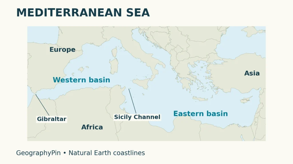
The Mediterranean Sea lies between Europe, Africa and southwestern Asia. Gibraltar connects it to the Atlantic, while the Sicily Channel links its western and eastern basins. Smaller seas, including the Adriatic and Aegean, belong to the same system. Its bordering coasts include mainland countries, island states and territories that simple country totals can overlook.
How to use this article: Start with the basin map, locate the smaller seas, compare coastal groups, or follow the three connections.
1. Where the Mediterranean Sea lies
A sea between Europe, Africa and Asia
The Mediterranean stretches between southern Europe and northern Africa, reaching southwestern Asia at its eastern end. Its outline is much less simple than a long oval. Peninsulas, islands and narrow passages divide it into recognizable regions without separating them from the larger sea.
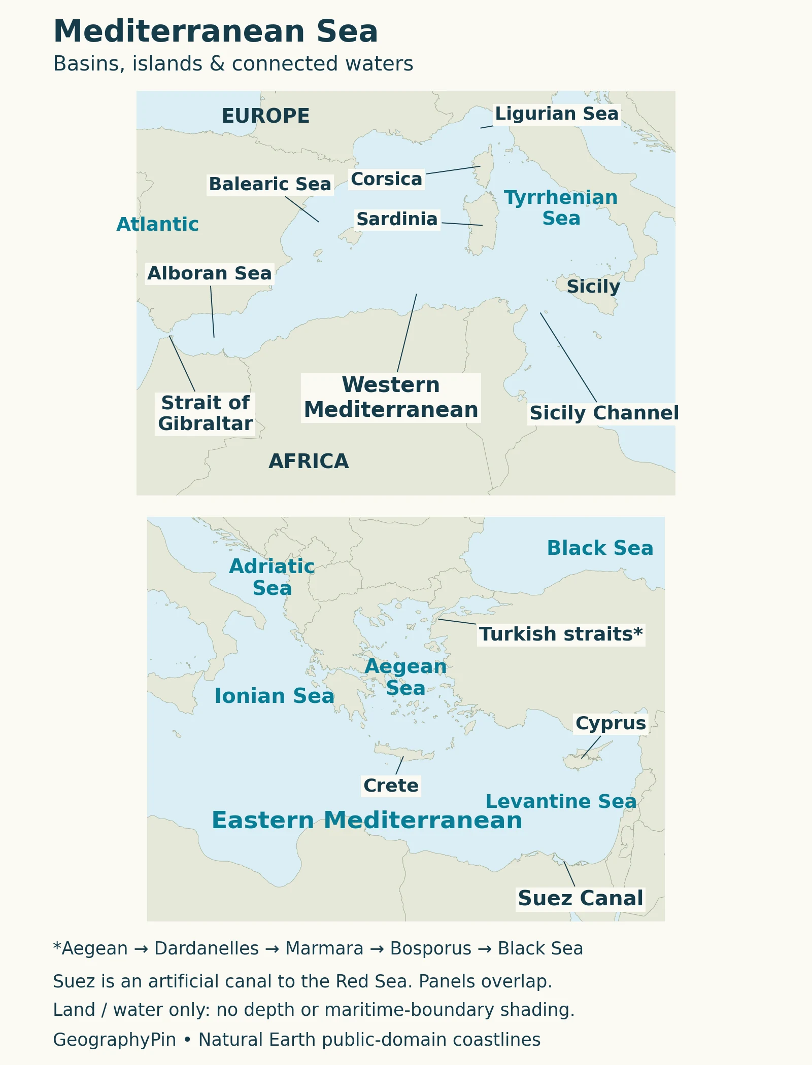
Use three landmarks to orient yourself: Gibraltar at the western entrance, Sicily near the middle, and Cyprus toward the east. The Italian peninsula projects south into the basin; Greece and its islands shape the northeastern waters. These landmarks make it easier to place a smaller sea or an unfamiliar coastline in the larger picture.
On the world ocean map, the Mediterranean is a connected regional sea, not a sixth ocean. Its narrow entrances explain the term semi-enclosed: much of its perimeter is land, but water still exchanges with neighboring basins.
2. Western and eastern basins
Sicily is the central reference point
Oceanographers commonly distinguish a western Mediterranean basin from an eastern one, connected through the Sicily Channel between Sicily and North Africa. This is a physical-geography division, not a political boundary or a wall stopping water from moving between the two sides.
Research in the channel describes relatively fresher Atlantic-origin water moving eastward in the upper layers, while saltier intermediate water spreads westward below. The channel therefore connects different parts of a three-dimensional circulation system. A line across a flat map cannot show all of that vertical structure.
The distinction is useful when reading observations. A result measured in the eastern basin need not describe the western basin equally well; a summer survey need not represent a whole year. For example, a 2022 Sicily Channel study examined summer cruises over 2010–2020, rather than continuous measurements at every location throughout the Mediterranean.
Sicily is both a prominent island on the map and a convenient landmark for understanding the basin arrangement. It is not, by itself, a complete boundary definition: the connecting channel and underwater passages also matter.
3. The seas and islands within the Mediterranean
Smaller names within one connected system
A map may label the Adriatic, Aegean or Tyrrhenian Sea more prominently than the Mediterranean. Those names identify parts of the larger system rather than separate oceans. Use the surrounding land to keep them straight.
| Water body | Map landmark |
|---|---|
| Alboran Sea | Just east of Gibraltar, between southern Spain and northern Africa. |
| Ligurian Sea | North of Corsica, beside northwestern Italy. |
| Tyrrhenian Sea | Between western Italy, Corsica, Sardinia and Sicily. |
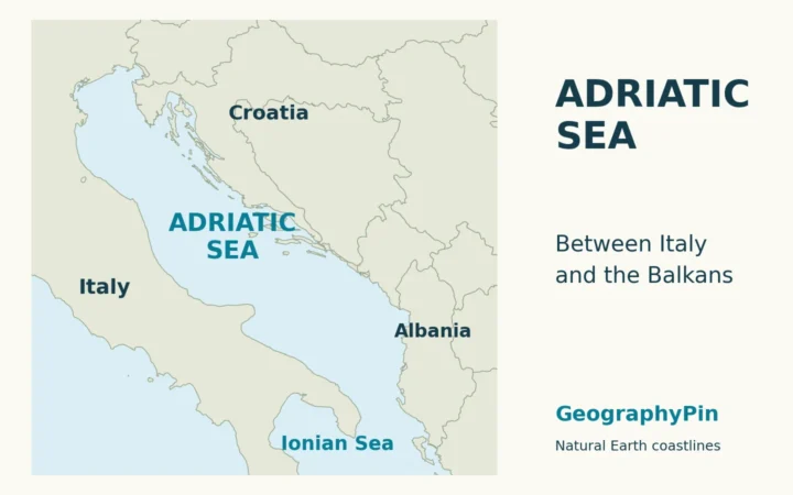
| Adriatic Sea | Between Italy and the western Balkan coast. |
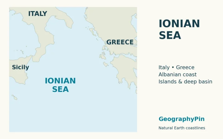
| Ionian Sea | South of the Adriatic, between southern Italy and western Greece. |
| Aegean Sea | Between Greece and Türkiye, north of Crete. |
| Levantine basin | Eastern Mediterranean waters around Cyprus and toward the Levantine coast. |
Major islands include Sicily, Sardinia, Corsica, Cyprus and Crete. They help divide the map into manageable pieces. Do not assume each island has a separate surrounding sea, or that every regional name denotes an equally formal hydrographic boundary. The table is an orientation guide, not a complete catalogue of every local sea name.
4. Bordering countries and coastal territories
Why country lists need a stated convention
A coast list and an environmental-treaty membership list answer different questions. UNEP/MAP identifies 21 countries plus the European Union as the Barcelona Convention’s 22 contracting parties. The first four rows below group those countries geographically; the final rows identify additional coastal territories rather than treating the institutional list as every Mediterranean shore.
| Geographic group | Countries or coastal territory |
|---|---|
| Northern shores | Spain, France, Monaco, Italy, Slovenia, Croatia, Bosnia and Herzegovina, Montenegro, Albania, Greece |
| North African shores | Morocco, Algeria, Tunisia, Libya, Egypt |
| Eastern and northeastern shores | Türkiye, Syria, Lebanon, Israel |
| Island countries | Malta, Cyprus |
| Palestinian coast | Gaza Strip, the Mediterranean coast of the occupied Palestinian territory |
| UK territories | Gibraltar; the Sovereign Base Areas of Akrotiri and Dhekelia on Cyprus |
The Palestinian coast should not disappear from a geographic account merely because it is absent from that treaty-country list. OCHA identifies Gaza’s Mediterranean coastline explicitly. UK territories are also distinct from independent coastal countries: the island of Great Britain itself does not border this sea.
Coasts on the Adriatic and other Mediterranean sub-seas count as Mediterranean coasts. The grouping here is a reader’s geographic guide, not an official regional classification or a claim about maritime jurisdiction. For a coast-focused companion, see the Mediterranean countries map.
5. Gibraltar, the Turkish Straits and Suez
Three connections with different geography
The Strait of Gibraltar is the natural passage linking the Mediterranean directly to the Atlantic. The Turkish Straits system connects it with the Black Sea through the Dardanelles, Sea of Marmara and Bosporus. Reading that sequence matters: the Bosporus does not open directly into the main Mediterranean basin.
The Suez Canal is different. It is an artificial sea-level waterway across Egypt, linking the Mediterranean at Port Said with the Gulf of Suez and the Red Sea. It is not a natural strait and is not the Mediterranean’s main oceanic water-exchange entrance.
The Suez Canal Authority describes a waterway crossing the isthmus between the two seas. Its presence creates a navigable connection that a natural-coastline map alone would miss. That is why the canal is labeled separately on the map rather than drawn as a wide natural gap across Egypt.
These connections answer different questions. Gibraltar helps explain Atlantic exchange; the Turkish Straits explain the Black Sea connection; Suez explains a constructed maritime route toward the Red Sea. Treating all three as equivalent openings hides the most useful part of their geography.
6. Why Mediterranean water is relatively salty
Evaporation and exchange work together
Across the basin, evaporation removes more freshwater than precipitation and river runoff supply. Water vapor leaves the dissolved salts behind. The imbalance is offset by net inflow through the sea’s connections, particularly Gibraltar, rather than by the Mediterranean simply emptying over time.
Relatively less saline Atlantic water enters the upper part of the system, while saltier Mediterranean water returns toward the Atlantic below. This is a broad circulation pattern, not a claim that every local surface current travels in the same direction. Winds, mixing, depth and basin-scale circulation complicate the pathways.
A 2023 Copernicus Ocean State Report study compared upper-ocean salinity datasets and found differences between the western and eastern Mediterranean and between products. A single salinity number should therefore carry a location, depth and time context. A coastal measurement, a basin-wide average and a trend are not interchangeable descriptions. The Mediterranean salinity explainer examines that process in more detail.
For the underlying movement mechanisms, see how ocean currents work.
What Did We Learn Today?
The Mediterranean’s smaller seas, two main basins and narrow connections form one connected geographical system. Gibraltar is an ocean gateway, Sicily is a central basin landmark, and Suez is an artificial connection. A useful coast list states its convention, while a useful circulation explanation separates broad exchange from changing local currents.
Sources & Data Notes
The coastal table distinguishes UNEP/MAP’s treaty-country list from additional Palestinian and UK-territory coasts. Geographic grouping is explanatory, not a jurisdictional classification. Original maps use Natural Earth coastlines; they do not draw exclusive economic zones, measured depths or current forecasts. Research periods are retained where examples are used, rather than presenting past surveys as live conditions.
- UNEP/MAP: Mediterranean marine and coastal environment (2017), regional physical geography and islands.
- UNEP/MAP: Contracting parties, the 21-country-plus-EU institutional convention.
- OCHA: Gaza geography, used only for the stable Mediterranean-coast identification, not dated access conditions.
- FCDO: UK overseas territory names, Gibraltar and the Cyprus Sovereign Base Areas.
- Placenti and colleagues (2022), Sicily Channel basin connections and research context.
- Aydogdu and colleagues (2023), Mediterranean freshwater balance and salinity variation.
- IODP Expedition 401 summary, modern Gibraltar–Alboran water exchange.
- Suez Canal Authority: About Suez Canal, the artificial Mediterranean–Red Sea connection.
- IHO: Limits of Oceans and Seas (1953), Mediterranean sub-sea geographic naming conventions.
- Natural Earth terms of use, public-domain map data. Cartography: GeographyPin.