A bold arrow across an ocean map hides a complicated flow. Real currents change with depth, time and location, and water can move vertically as well as horizontally. Understanding the main drivers helps explain both the broad pattern and the exceptions.
Ocean currents are directed movements of seawater. Wind, water-density differences and tides help drive them, while Earth’s rotation, coastlines and seafloor shape influence their paths. Surface and deep circulation are connected through sinking, upwelling and mixing. A simplified current map shows a broad pattern, not the exact flow at every place and time.
How to use this article: You can separate current from tide, understand sinking and deep flow, compare upwelling and downwelling, or read a current map.
A Current Moves Water From One Place to Another
Currents transport water and the heat, salt, nutrients and other material it carries. Some extend across ocean basins; others are local flows through a channel or around a headland. They can persist, reverse, meander or form swirling eddies.
NOAA identifies wind, density differences and tides as three main drivers. These are not three sealed compartments: several influences can act on the same body of water.
| Influence | What it does | Useful distinction |
|---|---|---|
| Wind | Transfers momentum to the upper ocean | Surface flow need not point exactly along the wind |
| Density differences | Help organize sinking and overturning circulation | Temperature and salinity both matter |
| Tidal forcing | Produces regularly varying water movement | Current speed is not the same measurement as tide height |
Tide height and current velocity are different
A tide describes the periodic rise and fall of water level. A current describes water movement, usually reported with a direction and speed. Tides can generate currents, but a tide-height table does not by itself give the current velocity at every nearby location.
Surface waves are different again: their moving crests describe a traveling disturbance. Waves can interact with and generate currents, so it is misleading to assume that every visible moving surface pattern traces the water’s full journey.
Wind and Rotation Shape Large Surface Patterns
Wind exerts stress on the ocean surface and transfers momentum into the upper water. The resulting circulation is also shaped by pressure differences, Earth’s rotation and the boundaries of the ocean basin.
The Coriolis effect deflects moving water to the right of its motion in the Northern Hemisphere and to the left in the Southern Hemisphere. It influences the flow rather than acting as a motor that starts water moving from rest.
NOAA’s ocean-current overview describes how these influences help organize large surface currents. Broad rotating systems are called gyres, but real flows also contain eddies and changing branches.
Warm currents transport relatively warm water into cooler regions; cold currents bring relatively cool water into warmer surroundings. Those labels are comparative, not fixed temperature categories. The Pacific Ocean guide gives regional examples such as the Kuroshio, California and Humboldt currents.
A named current is therefore not a solid-sided river pipe. Its position, width and strength can vary, and a simplified arrow leaves out much of that structure.
Density Connects Surface and Deep Circulation
Sinking depends on the surrounding water
Seawater density depends on temperature, salinity and pressure. At comparable pressure, cooling seawater or increasing its salinity generally makes it denser. If surface water becomes sufficiently dense relative to water below, it can sink and contribute to deeper circulation.
Cooling and salt changes are different processes. Evaporation removes water and can raise salinity; rainfall and river inflow add fresh water and can lower it. Cooling does not, by itself, add salt. Regional contrasts are discussed in the Indian Ocean guide.
Thermohaline combines temperature and salinity. The term describes their role in circulation, but the ocean is not driven by density alone. Wind, tides and mixing help connect water at different depths.
The familiar “global conveyor belt” is a teaching model of connected surface and deep circulation. It should not be read as one narrow, fixed track followed by every water parcel. The Australian Bureau of Meteorology describes upwelling and wind- and tide-driven mixing as parts of the return toward the surface.
Changes in circulation matter because water movement redistributes heat and influences the ocean’s exchange and storage of carbon and oxygen. A single warm or cold patch, however, cannot diagnose the state of an entire circulation system.
Tidal Currents Change With the Tidal Cycle
The gravitational interactions of Earth, the Moon and the Sun produce tides. Coastal geometry and water depth shape how the tidal motion appears in a particular bay, estuary or channel.
In a reversing tidal flow, flood generally describes movement into a bay or toward land, while ebb describes movement outward toward the sea. These are current directions, not a claim that every tidal current everywhere follows one simple back-and-forth path.
NOAA’s tidal-current tutorial explains reversing currents and the slack period as the tidal component changes direction. Other current components can still be present, and actual conditions may differ from the predicted tidal component because of wind or river discharge.
For navigation, use current predictions for the relevant station, depth and time together with current marine information. A general ocean-current diagram or nearby tide-height number is not an operational substitute.
Upwelling and Downwelling Link the Layers
Watch what replaces the displaced water
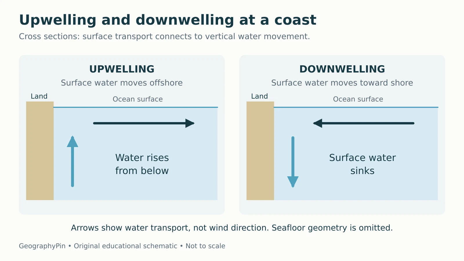
Upwelling occurs when deeper water rises toward the surface. In a common coastal case, wind-related surface transport moves water away from shore, and water from below rises to replace it. The transport direction need not match the wind direction.
Downwelling is the reverse vertical motion. When surface transport accumulates water against a coast, water can sink. NOAA’s upwelling explanation describes both processes and notes that upwelling also occurs away from coasts.

Upwelled water is often colder and rich in nutrients that support phytoplankton growth. That helps explain the productivity of many upwelling regions. The outcome still depends on light, nutrient supply and the wider ecosystem; upwelling is not a guarantee of unlimited fish production.
Read Current Maps With Five Checks
Match the arrow to the map’s purpose
- Check the depth. A surface-current map does not describe the entire water column.
- Check the time. Distinguish a long-term mean, an observation and a forecast.
- Read the legend. Arrow length or color may represent speed, direction or another variable.
- Check units. Currents are often expressed in knots or meters per second; one knot is about 1.15 miles per hour (0.514 meters per second).
- Check the scale. A basin-wide arrow cannot resolve a harbor entrance, beach current or narrow channel.
The Bureau of Meteorology notes that detailed current maps look more irregular than textbook diagrams, with temporary eddies and seasonal changes. Treat the simple map as an explanation of the larger circulation, then use suitable observations or forecasts for a specific place.
What Did We Learn Today?
Ocean currents reflect interacting drivers: wind, density differences and tides. Rotation, coastlines and the seafloor shape their paths, while sinking, upwelling and mixing connect depths. Read a current map’s depth, date, units and purpose before applying it to a location, and keep broad teaching diagrams separate from operational forecasts.
Sources & Data Notes
This is a conceptual explanation, not a current forecast or navigation guide. The original diagram shows idealized coastal water transport and omits wind vectors, the seafloor profile and scale. Surface, deep and tidal labels describe useful aspects of circulation rather than completely independent systems. Unit conversions are rounded.
- NOAA National Ocean Service: What is an Operational Forecast System?
- NOAA National Ocean Service: Why does the ocean have waves?
- NOAA JetStream: Sea Water
- NOAA National Ocean Service: What is a current?
- NOAA Education: Ocean currents
- NOAA National Ocean Service: Tidal Currents
- NOAA National Ocean Service: What is upwelling?
- Australian Bureau of Meteorology: Ocean currents