Twenty-two countries border the Mediterranean Sea under the convention used here: 21 United Nations member states plus the State of Palestine, whose Mediterranean coast is in the Gaza Strip. The list includes the Adriatic, Ionian and Aegean seas, as well as the island countries of Malta and Cyprus. British overseas territories are explained separately.
A Mediterranean countries map is useful only if it explains what counts. Some lists describe a treaty, others describe a climate region, and others count coastal countries. This guide follows the coast, shows the countries on a numbered map, and explains the small coastal areas that are easy to miss.
Start here: Compare the numbered map with its country key, then read why other lists count differently.
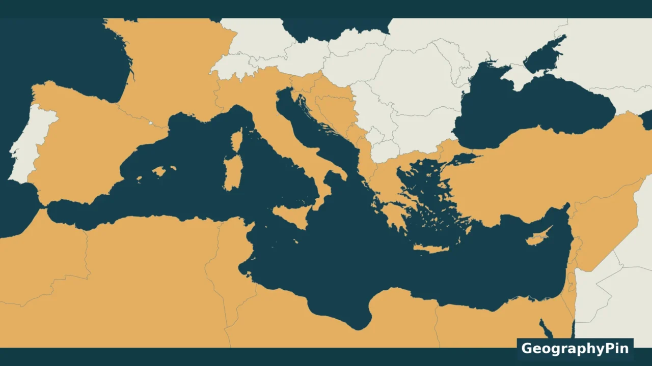
1. Mediterranean Countries Map
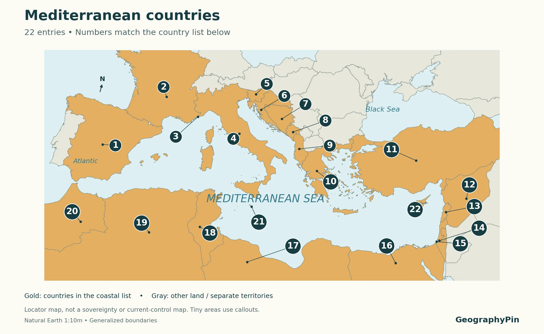
The gold areas belong to countries in the coastal list. Numbers identify countries, not capitals or ports. A line connects each displaced number to its country; this keeps very small places visible without pretending they are larger than they really are.
Open the larger map · Download the printable map (PDF) · Download the country list
On a phone, open the larger map to inspect the small eastern Mediterranean and Adriatic coasts. The table remains the complete key: map shading alone cannot make tiny coastal territories legible at this regional scale.
2. The 22-Country List
Start with Spain and follow the mainland coast clockwise through southern Europe and the eastern Mediterranean, then return west along North Africa. Malta and Cyprus complete the list as island countries. The coastal descriptions are locators, not an exhaustive list of every named sea along each country’s shore.
| Map number | Country | Coast or location |
|---|---|---|
| 1 | Spain | Western Mediterranean |
| 2 | France | Northwestern Mediterranean |
| 3 | Monaco | Ligurian coast |
| 4 | Italy | Central Mediterranean |
| 5 | Slovenia | Adriatic Sea |
| 6 | Croatia | Adriatic Sea |
| 7 | Bosnia and Herzegovina | Adriatic Sea at Neum |
| 8 | Montenegro | Adriatic Sea |
| 9 | Albania | Adriatic and Ionian Seas |
| 10 | Greece | Ionian and Aegean Seas |
| 11 | Türkiye (Turkey) | Aegean and eastern Mediterranean |
| 12 | Syria | Eastern Mediterranean |
| 13 | Lebanon | Eastern Mediterranean |
| 14 | Israel | Eastern Mediterranean |
| 15 | State of Palestine | Gaza Strip coast |
| 16 | Egypt | Southern Mediterranean |
| 17 | Libya | Southern Mediterranean |
| 18 | Tunisia | Southern Mediterranean |
| 19 | Algeria | Southern Mediterranean |
| 20 | Morocco | Southwestern Mediterranean |
| 21 | Malta | Island country south of Sicily |
| 22 | Cyprus | Island country in eastern Mediterranean |
How to read the count: the State of Palestine is included through Gaza’s coast, not the landlocked West Bank. Its UN status is that of a non-member observer state. This is why the guide says “21 UN member states plus the State of Palestine” rather than calling all 22 UN member states.
The table is consistent with the country roster used in the UNEP/MAP–Plan Bleu Mediterranean sustainability dashboard. It is not the same thing as the membership list of the Barcelona Convention. That distinction matters when comparing totals from different sources.
For broader geographic context, use our Europe countries map alongside the northern shore and our guide to Algeria for one of the North African coastal countries.
3. Small Coasts and Island Countries
The Adriatic coast is part of the Mediterranean
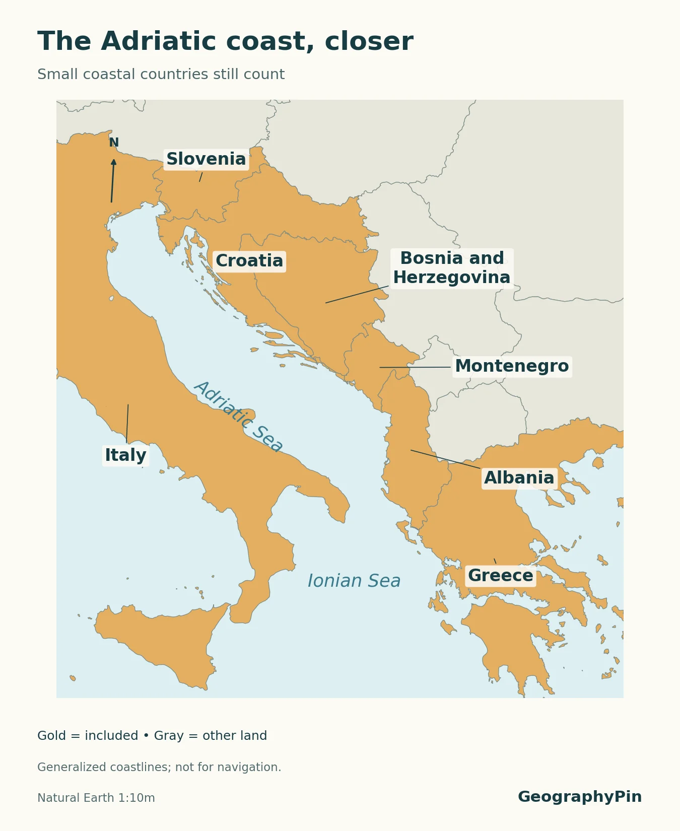
Countries do not need to face the broad open basin to qualify. The Adriatic is a Mediterranean sea, so Slovenia, Croatia, Bosnia and Herzegovina, Montenegro and Albania belong on the list, along with Italy. Albania also reaches the Ionian Sea; Greece has Ionian and Aegean shores.
Bosnia and Herzegovina is the easiest entry to overlook. It reaches the Adriatic around Neum, between sections of Croatia’s coast. A small-scale map can hide that outlet beneath a border line. Slovenia’s coast at the northern end of the Adriatic is another reason not to determine the list simply by glancing at a world map.
Open the Adriatic detail · Download the detail map (PDF)
Malta and Cyprus count; every island does not
Malta and Cyprus are countries in their own right. Sicily, Sardinia, Corsica, Crete and the Balearic Islands are not additional countries: their coasts belong to countries already listed. Counting every island as a separate entry would confuse geographic features with political units.
Cyprus appears once in the table. The map combines the island’s principal Natural Earth map units for this country-level illustration; it does not attempt to show current administrative control. The British Sovereign Base Areas are separate territories, discussed below.
Monaco and the Gaza coast need callouts
Monaco is included even though its Mediterranean frontage is difficult to see at regional scale. The same map-reading problem occurs along the densely packed eastern shore, where Lebanon, Israel and the Gaza Strip occupy relatively small areas. The leader lines and numbered table are more reliable than judging the width of a colored patch.
No minimum coastline length is required for inclusion here. We also avoid publishing a coastline-length ranking: measurements depend on the scale and method used, and such a ranking would answer a different question.
4. Why Other Lists Give Different Totals
Countries and overseas territories are different lists
Gibraltar is a British Overseas Territory at the Mediterranean’s western entrance, and Akrotiri and Dhekelia are British Sovereign Base Areas on Cyprus. They are not additional sovereign countries. This guide lists the region’s coastal countries and explains these territories separately; it is not an exhaustive count of every sovereign state exercising jurisdiction over any Mediterranean shore.
That scope is important for the United Kingdom. Its overseas territories have Mediterranean coasts, but the UK is not added as another entry in this regional 22-country convention. A jurisdiction-based list could organize the information differently. Neither approach should hide its definition.
Barcelona Convention parties are not a shoreline census
UNEP lists 22 contracting parties to the Barcelona Convention: 21 countries and the European Union. The EU is not another coastal country, and that treaty list does not include the State of Palestine. Consequently, seeing the number 22 on a UNEP page does not by itself tell you what was counted.
Use the table above for the geographic list, and the official contracting-parties page for treaty membership. This is a case where the same total can describe two different sets.
A sea connection is not a Mediterranean coastline
The Strait of Gibraltar connects the Mediterranean with the Atlantic. The Turkish straits connect it with the Black Sea through the Sea of Marmara. The Suez Canal links the Mediterranean and Red Sea. Those connections do not make every country on the Atlantic, Black Sea or Red Sea a Mediterranean coastal country.
Türkiye and Egypt do qualify because they have Mediterranean shores of their own. A country cannot qualify solely because ships can travel from its coast into the Mediterranean. Likewise, “Mediterranean climate” describes a climate pattern, not membership in this coastal list.
Frequently Asked Questions
Is Portugal a Mediterranean country?
Portugal has an Atlantic coast, not a Mediterranean coastline. It is therefore absent from this coastal list, even though “Mediterranean” can be used more broadly in discussions of climate, food or culture.
Does a country need to border the open Mediterranean to count?
No. A coastline on a component sea such as the Adriatic, Ionian or Aegean qualifies. That is why the small Adriatic coastal countries appear alongside Spain, Egypt and other countries facing the broader basin.
What Did We Learn Today?
A clear Mediterranean countries list needs a clear definition. This guide counts 21 UN member states plus the State of Palestine, includes the Mediterranean’s component seas, and counts Malta and Cyprus as island countries. Small coastal outlets still matter, while overseas territories and treaty membership need separate explanations. The numbered map and table work together so that no tiny coast has to carry the whole explanation.
Sources & Data Notes
The country roster follows the Mediterranean-region list in UNEP/MAP–Plan Bleu’s sustainability dashboard, with UN status stated separately. GeographyPin created the maps from Natural Earth 1:10 million administrative polygons, version 5.1.1, using a Lambert azimuthal equal-area projection centered on the Mediterranean. Numbered anchors were checked against the source polygons. Coastlines and borders are generalized; these are locator maps, not official boundary, navigation or current-control maps. Country shading does not settle disputed sovereignty. Natural Earth data are public domain; no third-party map was reproduced.
- UNEP/MAP–Plan Bleu: Mediterranean sustainability dashboard — regional country roster, page 2.
- UNEP: Barcelona Convention contracting parties — 21 countries and the European Union.
- United Nations: non-member observer states — status of the State of Palestine.
- UK Government: overseas territories names — Gibraltar and the Sovereign Base Areas.
- Council of Ministers of Bosnia and Herzegovina: about the country — Adriatic outlet at Neum.
- Nations Online: Mediterranean region — cross-check of sea connections and regional geography.
- Natural Earth: 1:10 million countries and public-domain terms — original map geometry and reuse terms.