The Baltic Sea stretches into several long gulfs, so a familiar name on one shore may be far from another Baltic destination. Its map becomes easier to read when the coastal countries, the northern and eastern arms, and the southwestern ocean connection are considered separately.
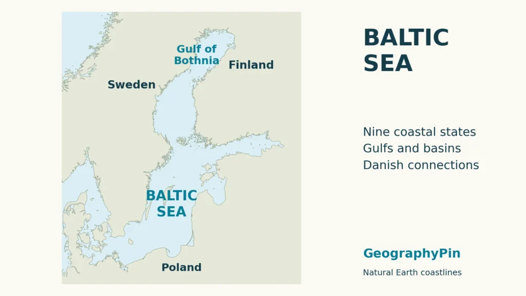
The Baltic Sea is a northern European sea bordered by Denmark, Germany, Poland, Lithuania, Latvia, Estonia, Russia, Finland and Sweden. The Danish straits connect it toward the North Sea. Its main basin branches into the gulfs of Bothnia, Finland and Riga, while freshwater inputs and restricted marine exchange make its waters brackish.
How to use this article: Find the coastal countries, compare the basin names, or see where winter ice develops.
1. Where the Baltic Sea lies
Sweden forms much of the western side of the Baltic, with Finland toward the northeast and the continental European coast to the south and east. Denmark occupies the entrance region. Farther north, the Gulf of Bothnia runs between Sweden and Finland; the Gulf of Finland extends east toward Russia between Finnish and Estonian shores.
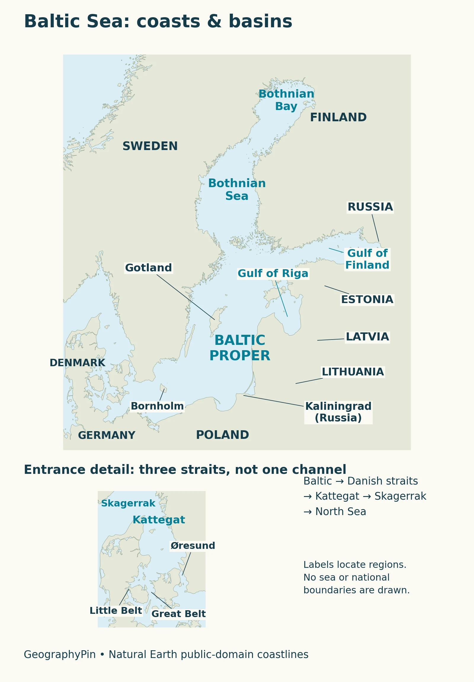
The main islands offer useful landmarks. Gotland and Öland lie off Sweden, while Saaremaa and Hiiumaa lie off Estonia. Åland lies between Sweden and mainland Finland. These islands help locate surrounding waters, but an island name and a sea-basin name are not interchangeable.
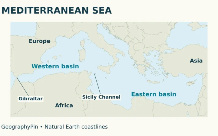
The Baltic is connected to the Atlantic system rather than being a landlocked lake. At a broader scale, the world ocean map places these northern European seas within that connected system. At the regional scale, the narrow passages around Denmark explain why the Baltic differs so much from the open Atlantic.
2. The Danish straits and the route to the North Sea
Three passages, not one wide opening
The entrance includes the Great Belt, Little Belt and Øresund, also called the Sound. The routes lead into the Kattegat, then through the Skagerrak toward the North Sea. Kattegat and Skagerrak are therefore useful names to recognize before following the Baltic’s water exchange.
The Estonian Ministry of Climate describes the narrow, shallow entrance as a restriction on marine exchange. Relatively fresh surface water generally moves outward, while saltier water can enter beneath it. Actual flows vary; the straits are not a set of identical pipes carrying fixed currents.
Shallow thresholds also separate many internal basins. These underwater ridges, called sills, influence the movement of deeper water. A sea that looks continuous from above can consequently contain basins with different circulation and mixing conditions. A coastline locator shows the connections, but it does not by itself show the depth of each passage.
3. Nine coastal countries and the main basins
Coastal countries are not the same as the Baltic states
HELCOM identifies nine countries with Baltic Sea shores. Starting in the southwest and following the southern and eastern side gives Denmark, Germany, Poland, Lithuania, Latvia and Estonia, followed by Russia and Finland around the northeastern arm, and Sweden along the west. Russia also has a separate Baltic coast at Kaliningrad, between Poland and Lithuania.
The term Baltic states usually means Estonia, Latvia and Lithuania. It does not include every country around the sea. Likewise, a country can send river water into the Baltic’s drainage basin without possessing a Baltic coastline. These are three different ways of grouping places: political region, coastal neighbors and catchment.
How the main water areas fit together
| Water area | Where it fits |
|---|---|
| Baltic Proper | The central and southern main basin, including the Arkona, Bornholm and Gotland basin areas. |
| Gulf of Bothnia | The northern arm between Sweden and Finland. The Bothnian Sea and the more northerly Bothnian Bay are parts of it, not alternative names for the whole gulf. |
| Gulf of Finland | The eastward arm between Finland and Estonia, reaching Russia. It connects directly with the northern main basin. |
| Gulf of Riga | The eastern gulf between Latvia and Estonia, partly sheltered from the open Baltic by islands. |
| Åland Sea and Archipelago Sea | Waters around Åland and southwestern Finland, on the route between the main basin and the Gulf of Bothnia. |
The Finnish environment portal distinguishes the Bothnian Sea from the Bothnian Bay across the shallow Kvarken, also called the Quark. Its account also explains that the Gulf of Finland has no comparable sill at its mouth. The word “gulf” alone therefore does not tell you how freely deep water can enter.
The Gulf of Riga has its own connections. A 2022 review of Baltic salinity describes the Irbe Strait and the Väinameri sea area as shallow routes linking the gulf with the Baltic Proper. Its setting differs from the more open western end of the Gulf of Finland; the two eastern gulfs should not be treated as matching water bodies.
Basin labels on a general map are orientation aids. Monitoring organizations may divide these same waters into smaller assessment units for fisheries, nutrients or ecological status. A table of those units may have more entries without contradicting the larger geographic names used here.
4. Brackish water and the geography of winter ice
The surface becomes fresher away from the entrance
The graphic compares three broad surface-water regions using HELCOM’s 2023 overview.
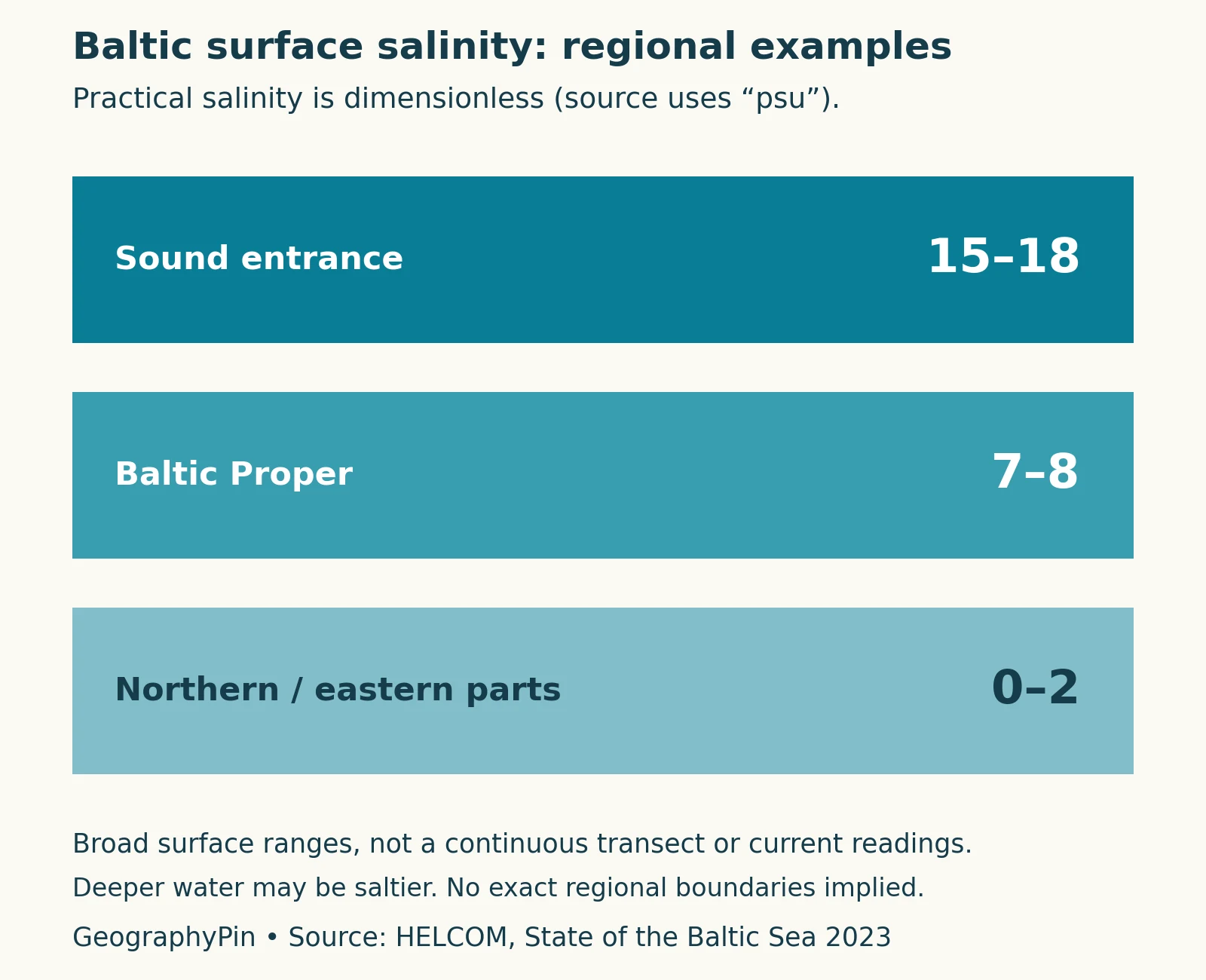
The pattern combines freshwater supply from rivers and precipitation with limited saltwater exchange. Surface and deep water can differ substantially, so a low surface value does not describe the whole column below it. The detailed explanation of why the Baltic Sea is brackish covers that water balance and layering.
Ice begins in the northern and sheltered eastern waters
According to the Finnish Meteorological Institute, freezing usually begins along the northern Bothnian Bay coast and in the inner Gulf of Finland. Ice cover expands differently in mild and severe winters. The annual maximum commonly falls near the end of February or the beginning of March.
In a mild winter, the Bothnian Sea may remain unfrozen while the Gulf of Finland freezes only partly. In severe winters, ice extends much farther southwest. That regional contrast is more useful than imagining the entire Baltic freezing on one date. Seasonal ice maps describe changing conditions, not a permanent boundary on the sea.
5. Why the surrounding land matters
The sea receives water from a catchment extending beyond its coastal countries. What happens on that land can therefore affect marine conditions even far from the nearest national shoreline. The connection runs through rivers as well as through direct discharges and atmospheric inputs.
HELCOM’s 2016–2021 eutrophication assessment found continuing pressure from excess nutrients. Increased phytoplankton production can reduce underwater light, while decomposition contributes to oxygen loss near the bottom. Nutrient inputs had declined, but not every basin had achieved its input targets.
This pressure should not be confused with brackishness. Salinity describes dissolved salts; eutrophication concerns excess nutrient enrichment and its ecological effects. A northern gulf with fresher surface water is not automatically cleaner, and a salty entrance is not automatically more polluted. Basin geography helps organize observations, but water quality needs its own evidence.
6. Reading Baltic Sea measurements
Keep the location and water layer attached to any salinity number. The range graphic describes surface conditions over broad regions; it is neither a continuous transect nor a deep-water profile. Practical salinity is dimensionless, commonly labeled “psu,” and a value of 7 does not mean 7% salt. TEOS-10 distinguishes it from Absolute Salinity in grams per kilogram.
Area and depth comparisons also require a consistent definition of the sea and its entrance waters. Ice extent is a different quantity again: it measures how far ice spreads, not its thickness. Reading these labels carefully prevents a geographic overview from turning regional examples into universal rules.
What Did We Learn Today?
The Baltic map is easier to understand as a main basin with several connected gulfs and a restricted southwestern entrance. Its nine coastal countries are a different grouping from the three Baltic states. Basin connections, regional salinity and winter ice reveal important differences within the sea, while nutrient pressures require evidence separate from salinity.
Sources & Data Notes
Salinity ranges follow HELCOM’s 2023 regional surface convention, not live observations or interpolated values. Geographic basin names are not maritime borders. The nutrient discussion refers to the 2016–2021 assessment, while the ice description gives seasonal patterns rather than a forecast.
- HELCOM: the nine coastal countries
- Estonian Ministry of Climate: entrance passages and exchange
- Finnish environment portal: Baltic geography and islands
- Finnish environment portal: basins and connecting waters
- Lehmann et al. (2022): Salinity dynamics of the Baltic Sea
- HELCOM (2023): representative surface salinity
- Finnish Meteorological Institute: the Baltic ice season
- HELCOM (2023): eutrophication assessment
- TEOS-10: salinity conventions
- Natural Earth: public-domain map data