The Adriatic’s two shores can look surprisingly different on a map: a long Italian coastline faces an eastern shore broken by islands and channels. Its shallow northern waters and deep southern basin add another contrast, while the southern entrance raises a small but important question about where one named sea ends and the next begins.
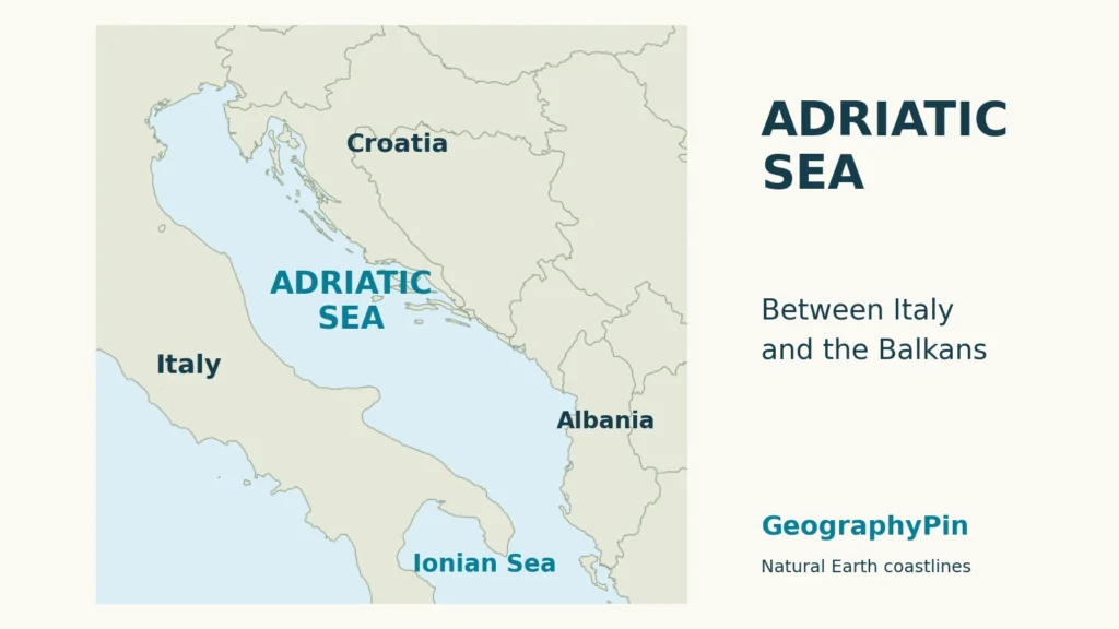
The Adriatic Sea is part of the Mediterranean, between Italy and the western Balkan coast, opening south through the Strait of Otranto toward the Ionian Sea. A common regional grouping identifies six coastal countries. Its geography combines northern shallows, a deeper southern basin, river-built coastal plains and island-lined eastern shores.
How to use this article: Locate the coastal countries, examine the seabed profile, or compare delta and island coasts.
1. Where the Adriatic Sea lies
Italy on one side, the Balkans on the other
The Adriatic is the long Mediterranean arm between the Italian Peninsula and the western Balkan coast. Its northern end reaches toward Slovenia and northeastern Italy; its southern opening leads into the Ionian Sea. On a regional map, follow the water southeast rather than looking for a separate outlet to the Atlantic.
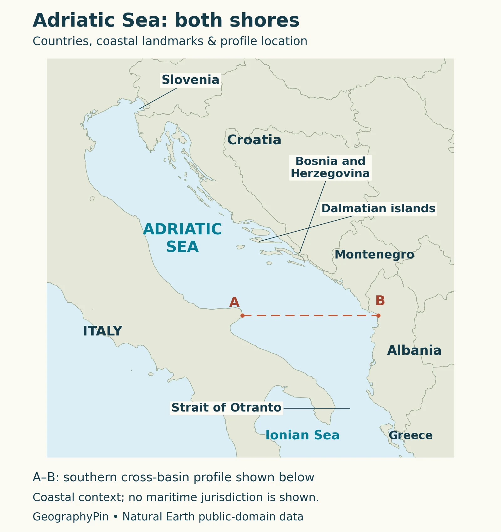
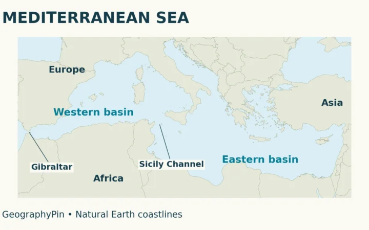
The Adriatic and Ionian are neighboring parts of the Mediterranean Sea, not separate oceans. Their names remain useful because they identify different basin shapes and coastal settings within that connected system. The world ocean map places the wider Mediterranean connection in context.
2. Countries along the Adriatic coast
The six-country regional convention
A common regional description names six Adriatic coastal countries: Italy, Slovenia, Croatia, Bosnia and Herzegovina, Montenegro and Albania. A 2023 marine-science study uses this grouping for its Adriatic study area. It is the convention used in the table, rather than a claim that every historical sea-boundary definition produces exactly the same list.
| Country | Where to look on the map |
|---|---|
| Italy | Western shore and part of the northern end |
| Slovenia | Short northeastern coastal stretch |
| Croatia | Eastern coast with numerous offshore islands |
| Bosnia and Herzegovina | Short coastal frontage at Neum |
| Montenegro | Eastern shore between Croatia and Albania |
| Albania | Southeastern shore toward the southern opening |
Small stretches of coastline matter just as much as long ones when identifying coastal states. Bosnia and Herzegovina should not disappear from the list because its frontage is difficult to see on a small map. Likewise, the many Croatian islands do not represent additional countries.
For the larger regional list, compare the Mediterranean countries map. A country with an Adriatic coast also has a Mediterranean coast: the smaller sea name does not remove it from the larger geographic system.
3. Otranto and the southern sea boundary
A water gateway, not a political border
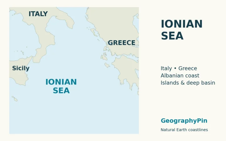
The Strait of Otranto provides the passage between the Adriatic and Ionian seas. Oceanographic research treats this opening as a route for water exchange, helping connect the Adriatic’s circulation with the eastern Mediterranean. It is not a closed southern wall.
The general gateway and an exact named-sea boundary are different things. The International Hydrographic Organization’s 1953 Limits of Oceans and Seas describes the Adriatic’s southern limit through the mouth of the Butrinto River, northern Corfu and Cape Santa Maria di Leuca. That older convention brings the Greek island of Corfu into the boundary description.
This is why the six-country regional list should not be presented as the only possible answer under every sea-limit convention. The locator shows nearby Greece for orientation but does not draw an exact southern limit. Neither the list nor a hydrographic naming line determines maritime sovereignty or exclusive economic zones.
4. Shallow northern waters and a deeper southern basin
What a southern cross-basin profile shows
The Adriatic seabed is not one evenly deep trough. A 2023 Copernicus Ocean State Report study describes a shallow northern shelf and a southern pit reaching roughly 3,900 feet (1,200 meters). These are broad regional descriptions, not a single depth applying everywhere or a newly surveyed exact maximum.
The profile below asks a different question: what happens when a line crosses the southern basin from west to east? It does not run from the shallow northern Adriatic to the deep south. Keeping those two directions separate prevents a misleading reading of the graphic.
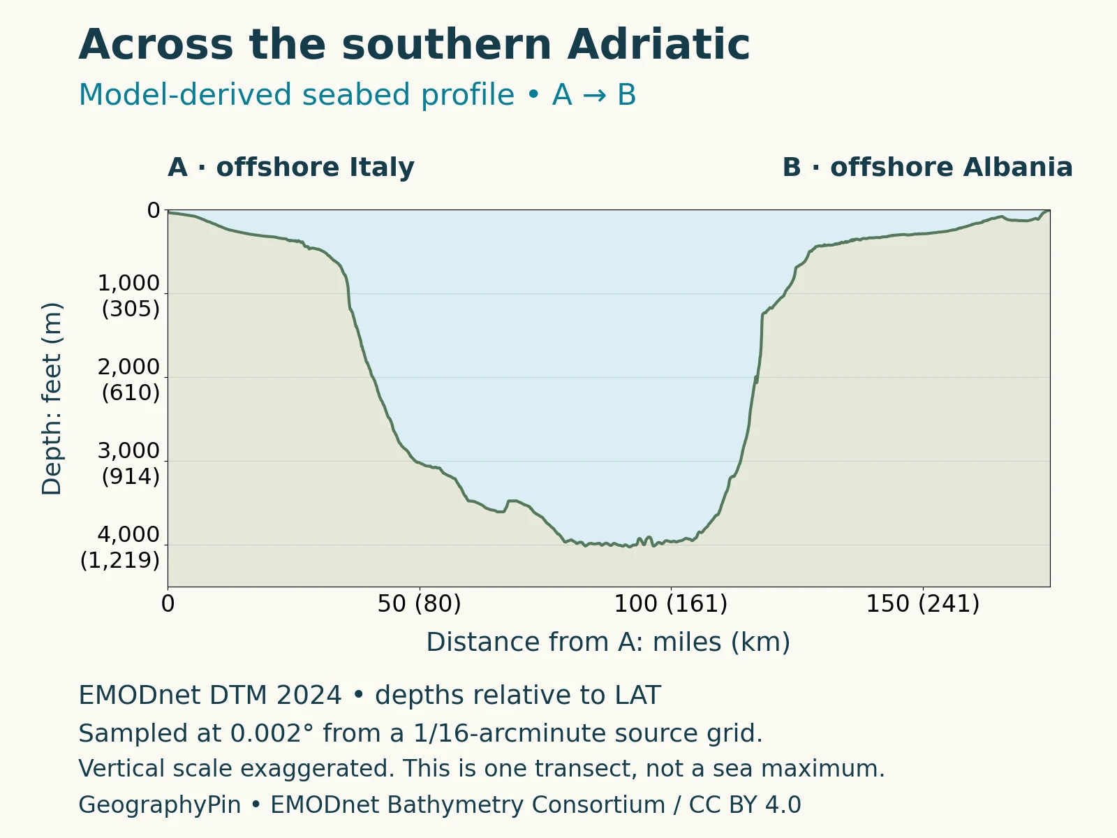
Read the horizontal axis as distance along A–B and the vertical axis as depth below the reference water level. The two axes use different scales, making the underwater slopes look steeper than their actual angles. The lowest point on this line is not automatically the deepest point anywhere in the sea.
This is a profile sampled from a seabed model, not a new ship survey. EMODnet combines several kinds of depth information, with gap-filling where needed; not every plotted point represents a direct sounding. Both endpoints are offshore, so the line should not be read as a beach-to-beach walking cross-section.
5. Why the Italian and eastern coasts look different
The Po Delta and the Dalmatian island coast
The most useful comparison is between specific coastal landscapes, not a blanket statement that Italy is flat and the opposite shore is mountainous. The Po Delta in northern Italy and Croatia’s Dalmatian island coast illustrate two very different ways land and sea can meet.
UNESCO describes the Po Delta as a plain shaped by the river and human activity. Its river branches, dunes, sandbars, lagoons and marshes form a low-lying coastal mosaic. Sediment is central to understanding this landscape: the coast is not simply a hard edge separating dry land from open water.
A lagoon is a coastal water body partly separated from the sea, while a delta develops around a river’s sediment-building mouth. The Po landscape includes both river-mouth landforms and sheltered coastal waters. Calling the whole area just a beach would miss the channels and wetlands that give it its shape.
Along much of the Croatian coast, elongated islands and channels run broadly parallel to the mainland. The Croatian Institute of Lexicography describes a landscape in which rising seas after the last ice age submerged valleys and basins. Higher ground remained above water, producing the island-and-channel pattern visible on the map.
Limestone is widespread there, but it is not a universal description of every island. The same reference identifies volcanic exceptions such as Jabuka and Brusnik, and the sandy island of Susak. Nor should the Croatian pattern be stretched over every part of Albania, Montenegro or the Italian shore.
Karst is terrain shaped by water dissolving soluble rock, commonly limestone, creating features such as caves and underground drainage. That process helps explain limestone landscapes, but it is not the same as sea-level rise flooding valleys: rock type, landform development and later submergence are related parts of the coastal story, not interchangeable explanations.
On a map, compare the outline and arrangement rather than assuming that two locations at the same latitude share the same coast. A delta’s branching waterways and an island chain’s long sea channels may both look intricate, but they record different landforms and histories.
6. Rivers, salinity and water circulation
The Adriatic does not share one uniform water balance
The Po is an important freshwater source, especially for the northern and western Adriatic, but it is not the only river feeding the sea. Alpine and Albanian rivers also contribute. River input changes salinity and density, so coastal water near an inflow need not resemble offshore water farther away.
A 2024 study reconstructing freshwater inputs over 1991–2022 describes an Adriatic balance in which rainfall and river runoff can exceed evaporation. That contrasts with the freshwater deficit usually described for the Mediterranean as a whole. A basin-wide explanation cannot simply be copied onto every sub-sea without checking its rivers and climate.
Winds, freshwater input and exchange through Otranto all help shape circulation. Cooling can also produce dense water that sinks and contributes to deeper-water renewal. These processes operate at different depths and change with conditions; a single surface arrow would not adequately explain the entire sea.
The geographic picture is therefore three-dimensional: coasts define the outline, seabed relief shapes the basin, and water properties influence movement within it. Neither the country map nor the depth profile is a forecast of currents or a chart for navigation.
What Did We Learn Today?
The Adriatic is best understood through contrasts: shallow north and deeper south, sedimentary delta and island-lined coast, regional country list and hydrographic boundary convention. The A–B profile crosses only the southern basin, while Otranto connects that basin with the Ionian and the wider Mediterranean.
Sources & Data Notes
The country table follows a modern six-country regional convention, separately from IHO’s historical naming limit. Depths in the text are rounded regional descriptions; the profile is a single sampled line from EMODnet DTM 2024, not a measured transect or a sea-wide maximum. Its returned grid spacing is 0.002°, coarser than the source model’s native spacing. Research periods describe the cited studies, not live water conditions.
- 2023 Adriatic marine-conservation study, study-area section and six coastal countries.
- IHO: Limits of Oceans and Seas (1953), printed page 17, Adriatic naming limit.
- Di Biagio and colleagues (2023), Adriatic bathymetry and circulation.
- EMODnet Bathymetry, model construction and limitations.
- EMODnet DTM 2024, profile data under CC BY 4.0; GeographyPin sampled and plotted the line.
- Croatian Institute of Lexicography: Adriatic Sea and islands, island form and geology.
- UNESCO: Po Delta, delta landscape and habitats.
- 2024 Adriatic freshwater-input study, reconstruction covering 1991–2022.
- USGS: EarthWord–Karst, dissolution and limestone landscapes.
- Natural Earth terms of use, public-domain basemap data; original cartography by GeographyPin.