A white patch around each pole can make the Arctic and Antarctica look interchangeable. Coastlines, ice types and seasons reveal why they are not. The most useful comparison separates the land beneath the ice from the changing ice on the ocean.
The Arctic is an ocean-centered region surrounded by northern lands; Antarctica is a continent surrounded by ocean. Both have sea ice and land ice, but their geography, seasons and governance differ. Arctic boundaries vary by definition, while Antarctica’s coastline must not be confused with the wider Antarctic Treaty area.
How to use this article: Compare the polar views, distinguish Arctic boundaries, identify different ice types, or check which seasons a map compares.
1. Read the polar maps: ocean at one pole, land at the other
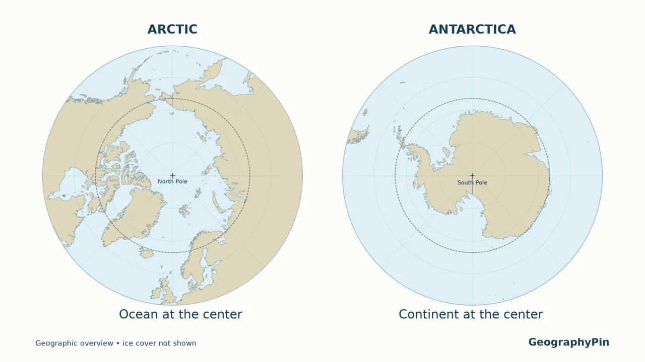
The clearest Arctic vs. Antarctica map starts with the coastline, not a blanket of white. At the North Pole, that white surface is floating sea ice over the Arctic Ocean. At the South Pole, it is part of an ice sheet resting on Antarctica. Removing the seasonal sea ice would expose water in both hemispheres, but it would not remove the Antarctic continent.
Map key: tan shows the mapped land/coastal outline; pale blue is the ocean background, not necessarily ice-free water. The solid magenta line marks the March median sea-ice edge and the dashed teal line the September edge. The gray dashed circle is the polar circle. Land-ice coverage is not mapped.
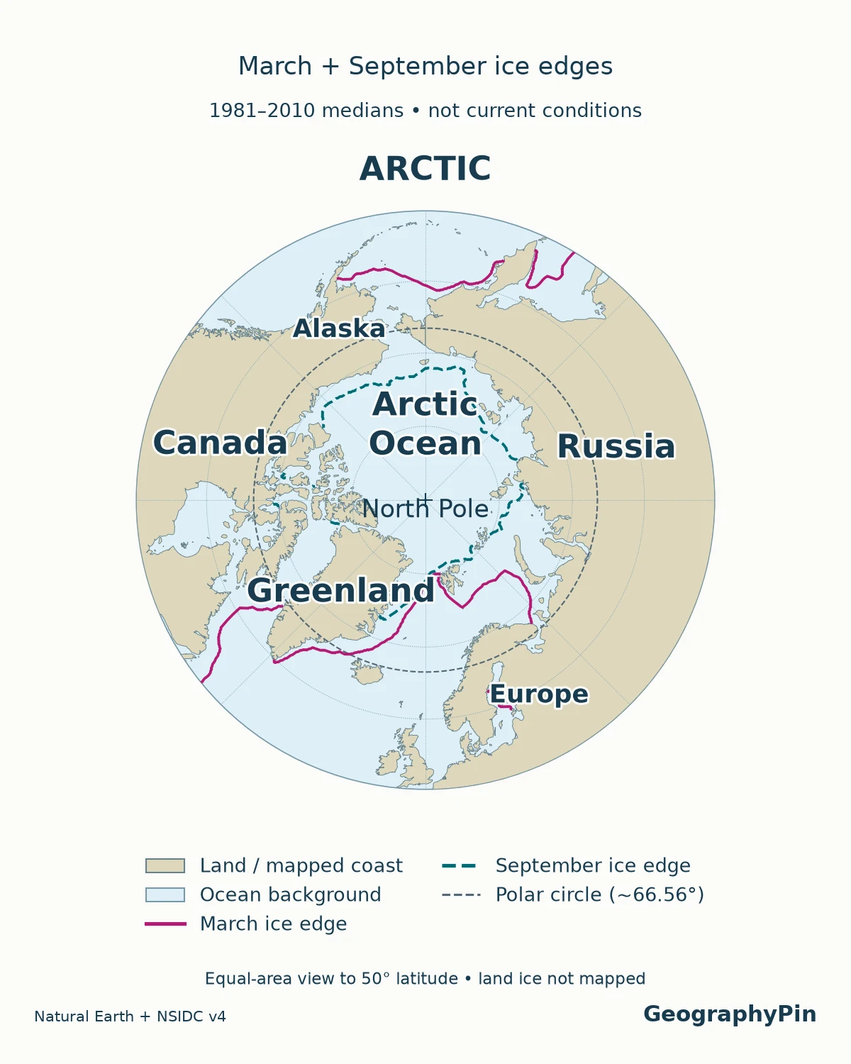
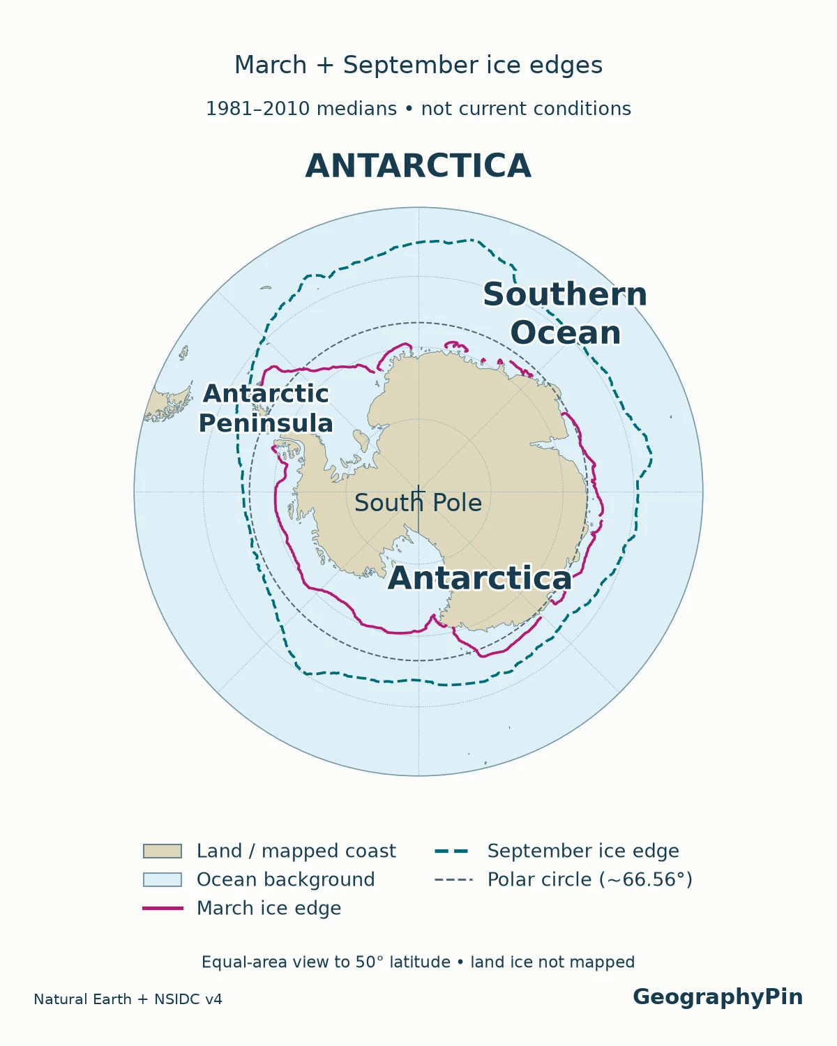
Both equal-area views extend to 50° latitude at matching scale. This display edge is not a regional boundary, and any ice-edge segments beyond it are cropped. Ice lines come from NSIDC Sea Ice Index Version 4 and its 1981–2010 reference period. They are historical monthly medians, not today’s conditions, a solid sheet of ice, or the exact annual maximum/minimum. NSIDC defines the median edge using grid cells where ice at 15% concentration or greater occurred with a 50% probability in the reference period. The generalized Natural Earth Antarctic outline is not a detailed grounding-line survey; floating shelves and grounded land ice are not separated.
How to compare the two views
Locate Greenland and northern Canada in the northern view, then find Antarctica in the southern view. Greenland is a large Arctic island with its own ice sheet; it is not a northern counterpart to the entire Antarctic continent. The Arctic also includes northern mainland areas and other islands, not just the water at its center.
Read the coast, latitude lines and ice layer separately. A coastline identifies the edge of land, a latitude circle is a geographic reference, and a sea-ice outline describes a particular measurement or reference period. None should silently stand in for the others. A polar view also avoids stretching the poles across the top and bottom of a rectangular world map.
The broader world oceans map provides the connection between these polar views and lower-latitude oceans.
2. Arctic and Antarctica compared
| Question | Arctic | Antarctica |
|---|---|---|
| What is at the pole? | Arctic Ocean beneath floating ice | Continental ice sheet above bedrock |
| Basic arrangement | Ocean largely surrounded by land | Continent surrounded by ocean |
| What defines its edge? | Several geographic and ecological conventions | Continental coastline; wider Antarctic region has other boundaries |
| Major land ice | Greenland Ice Sheet and other glaciers | Antarctic Ice Sheet and connected glaciers |
| Sea-ice cycle | Usually largest in March, smallest in September | Usually largest in September, smallest in February |
| People | Established communities, including Indigenous peoples | No Indigenous population; research and support personnel live at stations |
| Governance | National jurisdictions and international law | Antarctic Treaty System, with sovereignty positions preserved |
The seasonal months are typical timings, not guaranteed dates for every year. Likewise, “ocean surrounded by land” is a useful description, not a statement that the Arctic Ocean is sealed off from neighboring oceans.
3. Where does the Arctic begin?
Three boundaries that answer different questions
There is no single Arctic boundary that works equally well for daylight, vegetation and climate. The National Snow and Ice Data Center describes several common approaches:
- Arctic Circle: approximately 66.5° north latitude, a useful reference for the occurrence of continuous summer daylight and winter darkness.
- Northern tree line: the transition beyond which trees no longer grow, an ecological boundary that does not follow a neat circle.
- Summer temperature: an often-used climatic boundary follows a mean July temperature of 50°F (10°C), broadly related to the tree line.
These definitions can put the same location inside the Arctic under one convention and outside it under another. That is not automatically a cartographic error. The map must identify which question its boundary answers.
Nor should the Arctic Circle be treated as the edge of permanent ice. Land and ocean occur on both sides, while seasonal sea ice grows and retreats according to weather, ocean conditions and the time of year. For the land beneath the largest Arctic ice sheet, see Greenland’s bedrock geography.
Antarctica is not everything south of 60°S
Antarctica names the continent. The Antarctic can describe a broader region that includes surrounding waters. The Antarctic Treaty applies south of 60°S, including ice shelves, with a provision preserving high-seas rights under international law. That legal limit encloses ocean as well as the continent; it is not Antarctica’s coastline.
The Antarctic Circle, near 66.5°S, is a daylight-related latitude reference. It is different again from the treaty limit. Keeping these lines separate prevents a common mistake: coloring an entire circular treaty area as though it were solid land.
4. Sea ice, land ice and ice shelves are different things
Identify the ice before interpreting the map
Sea ice forms when ocean water freezes. It floats, moves with winds and currents, and can grow together into a pack. It has a different origin from an iceberg, even though both are made of water ice and both float.
Glaciers and ice sheets form from accumulated snow on land. Greenland and Antarctica both contain enormous ice sheets. Most large ice shelves are floating extensions of land ice that remain attached to it. Other shelves include ice built from sea ice and accumulated snowfall. An iceberg is a detached piece of glacial ice, often broken from a glacier or shelf. These distinctions follow NASA’s explanation of ice features.
This matters for sea level. Adding water from grounded ice to the ocean increases its volume. Melting sea ice has a much smaller direct effect because it already floats and displaces seawater. “Floating” also does not mean irrelevant: ice shelves can restrain the movement of grounded ice behind them.
On a map, a pale Antarctic surface may represent the ice-covered continent, floating shelves, or seasonal sea ice. Without a legend, the reader cannot tell which. A map of sea-ice extent also does not measure the thickness or total volume of ice.
5. Compare seasons, not just calendar months
March and September tell opposite stories
The hemispheres have opposite seasons. NSIDC’s Sea Ice Today identifies March as the usual Arctic maximum and September as its usual minimum. Antarctic sea ice usually reaches its minimum in February and maximum in September; the precise turning dates vary.
Consequently, two September maps compare the Arctic near the end of its melt season with Antarctic sea ice near its winter maximum. That is a legitimate same-month view, but not a comparison of equivalent seasons.
To compare the seasonal range, use each hemisphere’s late-winter maximum and late-summer minimum, then state the months and reference period. To compare change through time, keep the month, region, dataset and extent definition consistent. Mixing a single low-ice year with a decades-long average can create a striking picture without a fair comparison.
The surrounding geography also matters. Arctic sea ice occupies an ocean hemmed in by continents, with some ice surviving the summer. Antarctic sea ice expands outward into the ocean around the continent, and much of it disappears during summer. Neither a winter ice edge nor a summer minimum should be drawn as an unchanging regional border.
6. People and governance: two very different polar regions
The Arctic is not an empty wilderness outside national borders. It contains towns, cities, livelihoods and Indigenous homelands. The Arctic Council’s eight Arctic states are Canada, the Kingdom of Denmark, Finland, Iceland, Norway, Russia, Sweden and the United States. This grouping is not a claim that all eight have coastlines on the central Arctic Ocean or that their entire territories are Arctic.
National jurisdictions and international law govern the region. The Arctic Council is a forum for cooperation, not a sovereign government for the North Pole. Country membership is therefore another convention to keep separate from a climate boundary on a map.
Antarctica has no Indigenous population, according to the Australian Antarctic Program. Scientists and support teams live at stations, with activity varying by season. “No Indigenous population” does not mean “nobody lives there.”
The Antarctic Treaty establishes peaceful use and scientific cooperation. Article IV preserves the parties’ positions on sovereignty claims and prevents new claims or enlargement of existing ones while the treaty is in force. It does not simply erase all claims or create a new country. Antarctica’s wider history and geography belong in the separate Antarctica profile.
Frequently Asked Questions
Why is Antarctica generally colder than the Arctic?
The Antarctic interior is a high ice-covered plateau, whereas the North Pole lies near sea level over an ocean. Elevation and the different land-ocean arrangements help explain the contrast. Antarctic coasts and interior stations also differ greatly, so a temperature comparison needs matched locations and seasons, not one number for each entire region.
Do polar bears and penguins live together naturally?
No. Polar bears live in the Arctic, not Antarctica, and wild penguins do not inhabit the Arctic. Penguins also live outside Antarctica, so a penguin photograph alone does not establish that a place is on the Antarctic continent.
What Did We Learn Today?
A useful polar comparison separates coastline, regional boundary and ice cover. The Arctic contains an ocean, surrounding lands and established communities; Antarctica is a continent with a distinct treaty framework. Sea ice is not land ice, and opposite seasons mean the same calendar month can show very different stages of the annual ice cycle.
Sources & Data Notes
The comparison separates physical coastlines, ecological Arctic definitions and the Antarctic Treaty’s legal limit. Seasonal months describe typical timing, not fixed annual dates. No current ice-area ranking, population estimate or prediction of future ice loss is used. Original maps use Natural Earth and NSIDC Sea Ice Index Version 4; March and September median ice-edge lines share the 1981–2010 reference period. The map background does not measure land ice or present-day sea ice.
- NSIDC: Arctic Weather and Climate
- NSIDC: Sea Ice
- NSIDC: Science of Sea Ice
- NSIDC: Sea Ice Today
- NASA Goddard: Ice Basics
- Arctic Council: Arctic States
- Antarctic Treaty Secretariat: The Antarctic Treaty
- Antarctic Treaty: text, including Articles IV and VI
- Australian Antarctic Program: How many people live in Antarctica?
- Australian Antarctic Program: Antarctic weather
- Fetterer and colleagues (2025), Sea Ice Index, G02135 Version 4: Northern and Southern Hemisphere March/September 1981–2010 median ice-edge subsets.
- NSIDC Sea Ice Index Version 4 user guide
- Natural Earth: public-domain map data