How to use this article: If you want the fast list, jump to the 7 continents table. If you’re here for “how many continents,” go to 7 vs. 6 vs. 5 models. If you’re confused about borders, start at where boundaries are drawn. If you came for tectonics and deep Earth science, go to continents vs. tectonic plates. For quick answers, use the FAQ.
What are the continents of the world?
The continents are Earth’s largest landmasses as commonly recognized by tradition. In most English-language curricula, there are seven: Africa, Antarctica, Asia, Europe, North America, South America, and Australia (often taught alongside the wider region called Oceania). Because the idea is partly conventional, 5- and 6-continent models also exist in different traditions.
Jump to: What is a continent? · How many continents? · Boundaries · Tectonic plates · 7 continents table · FAQ · What did we learn?
What Is a Continent? Definition and Criteria
A continent is a very large area of land that people agree to treat as a distinct region. That word “agree” matters: the definition is conventional as much as it is scientific. Encyclopædia Britannica describes a continent as a “large continuous mass of land conventionally regarded as a collective region,” and notes that the familiar list taught in many places is seven.
In everyday geography, islands near a continent’s shallow continental shelf are often grouped with that continent (for example, Great Britain with Europe). In geology, however, the emphasis is on “continental crust,” which is thicker and less dense than oceanic crust. That geologic view can include submerged shelves and even mostly underwater regions—one reason some scientists argue for Zealandia as a distinct, mostly submerged continent.
Geographic vs. Geologic Views
Geography prioritizes map clarity, navigation, and human history—so boundaries often follow major landforms or long-standing traditions. Geology follows the rock: cratons, shields, and continental shelves. These lenses overlap, but they don’t match perfectly. That’s why “what is a continent?” can have more than one reasonable answer depending on what you’re trying to do.
| Metric | Geographic convention | Geologic perspective |
|---|---|---|
| Unit of analysis | Named landmasses recognized by tradition | Continental crust (often includes shelves and nearby islands) |
| Examples | “Europe,” “Asia,” “North America” | Cratons, shields; Zealandia as mostly submerged continental crust |
| Boundary style | Historical/cultural lines and major landforms | Crustal thickness, tectonic history, and shelf structure |
How Many Continents Are There? 7 vs. 6 vs. 5
There isn’t a single global “official” number, because the concept is partly conventional. The most common model in English-speaking schools is seven, but many education systems teach six, and the Olympic “five continents” idea is symbolic rather than geological.
- 7-continent model (common in English-language curricula): Africa, Antarctica, Asia, Europe, North America, South America, Australia (often described with the wider region “Oceania”).
- 6-continent models (common in several traditions): either Eurasia (Europe + Asia combined), or a single America (North + South America combined).
- 5-continent idea (Olympic symbolism): a cultural symbol focused on inhabited “parts of the world,” not a scientific boundary vote.
The 7-Continent Model
This is the default in many English-language atlases and textbooks. It keeps Europe and Asia separate for historical and cultural reasons, and it treats North and South America as distinct continents even though they connect at Panama.
The 6-Continent Models
Two common versions exist. One merges Europe and Asia into Eurasia. Another merges North and South America into a single America. Both are conventions used in real school systems, and both can be internally consistent.
The 5-Continent Idea (Olympic Symbolism)
The Olympic flag’s five rings symbolize unity across five inhabited “parts of the world” (often described as Africa, the Americas, Asia, Europe, and Oceania). It’s a cultural symbol—not a statement that Antarctica “doesn’t count.”
Where Are the Boundaries Drawn?
Some continental boundaries are obvious (coastlines and oceans). Others are traditions that try to balance physical geography with history and map practicality.
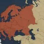
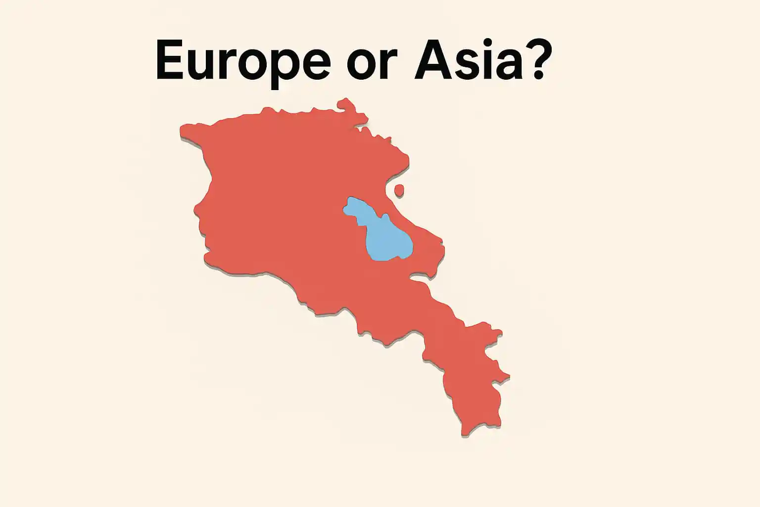
Europe–Asia: the “line” across one landmass
Europe and Asia share one continuous landmass, so the boundary is a convention. A commonly used geographic line is described in standard references and is typically taught as:
- Down the Ural Mountains and along the Ural River area
- To the Caspian Sea
- Then either along the Greater Caucasus crest or the Kuma–Manych Depression (depending on convention)
- To the Black Sea and through the Turkish Straits
If you ever see slightly different maps, that’s normal: the boundary exists to make the world easier to describe, not because a single physical “wall” separates the two.
Africa–Asia: the Suez land bridge
Africa and Asia meet at the Isthmus of Suez. In modern usage, many references treat the Suez Canal—about 120 miles (193 kilometers) long—as the practical dividing line because it is a clear, human-made separator that reshaped movement and trade.
North–South America: the Panama connection
North and South America connect at the Isthmus of Panama. The land bridge is about 50 miles (80 kilometers) wide at its narrowest point, which is why it plays such a big role in migration, biodiversity, and transportation routes.
Continents vs. Tectonic Plates
Continents and tectonic plates are not the same thing. Continents are named landmasses defined partly by convention. Plates are slabs of Earth’s lithosphere that move—typically a few centimeters per year (about 1–4 inches).
Some plates carry most of a continent. Others carry pieces of multiple continents, plus ocean floor. Over long time spans, continents merge into supercontinents (like Pangaea) and later split apart. These cycles shape mountain belts, ocean basins, and the shifting positions of today’s continents.
From Pangaea to Today (Very Short Timeline)
- ~335 million years ago: Pangaea assembled (approximate).
- ~200 million years ago: Pangaea began breaking apart (approximate), with northern and southern super-regions often described as Laurasia and Gondwana.
- Today: Plate boundaries like the Red Sea rift and East African Rift show that the map is still evolving.
Zealandia—A Mostly Submerged “Eighth” Continent?
Geologists have compiled strong evidence that the New Zealand–New Caledonia region sits on a distinct, mostly submerged continent called Zealandia (often described as about 94% underwater). It isn’t part of the traditional 7-continent school model, but it’s a great example of how a geologic lens can produce a different—yet internally consistent—definition.
List of the 7 Continents with Key Facts
The table below uses widely cited reference figures for land area and well-known highest points. Population share is shown as a rough, reader-friendly estimate because “continent” groupings and year-to-year estimates differ by source.
| Continent (7-model) | Area (sq mi / km²) | Highest point (ft / m) | Population share (approx.) | Boundary notes |
|---|---|---|---|---|
| Asia | ≈17,226,000 sq mi (≈44,614,000 km²) | Mount Everest — 29,031.69 ft (8,848.86 m) | ≈60%+ | Europe boundary is conventional (Urals/Caspian/Caucasus or Kuma–Manych) |
| Africa | ≈11,724,000 sq mi (≈30,365,000 km²) | Kilimanjaro — 19,341 ft (5,895 m) | ≈18–20% | Meets Asia at the Isthmus of Suez; many use the Suez Canal as the divider |
| North America | ≈9,355,000 sq mi (≈24,230,000 km²) | Denali — 20,310 ft (6,190 m) | ≈7–8% | Connected to South America at Panama (about 50 mi / 80 km wide at narrowest) |
| South America | ≈6,878,000 sq mi (≈17,814,000 km²) | Aconcagua — 22,831 ft (6,959 m) | ≈5–6% | Conventionally split from North America even though the land is continuous |
| Antarctica | ≈5,500,000 sq mi (≈14,200,000 km²) | Vinson Massif — 16,050 ft (4,892 m) | ≈0% | No permanent population, but it’s still a continent by landmass + plate/crust context |
| Europe | ≈3,930,000 sq mi (≈10,180,000 km²) | Mount Elbrus — 18,510 ft (5,642 m) | ≈9–10% | If you exclude the Caucasus, some sources cite Mont Blanc (15,771 ft / 4,807 m) as “highest in western Europe” |
| Australia (often taught with “Oceania”) | ≈2,968,000 sq mi (≈7,688,000 km²) | Puncak Jaya (often used for Oceania) — 16,024 ft (4,884 m) | ≈0.5–1% | “Australia” (continent landmass) vs “Oceania” (wider region) varies by source and school tradition |
FAQ
How many continents are there?
It depends on convention. The most common English-language model lists seven. Some traditions teach six (either merging Europe + Asia as Eurasia, or merging North + South America as a single America). The Olympic “five continents” idea is symbolic and focused on inhabited regions.
Why are Europe and Asia considered separate continents?
Mostly tradition. Europe and Asia share one landmass (often called Eurasia), but history and culture shaped a convention of treating Europe as distinct. The boundary is drawn using major landforms and agreed reference lines (Urals, Caspian region, and routes toward the Black Sea and Turkish Straits).
Is Australia a continent or is it “Oceania”?
Both terms are used in different ways. “Australia” often refers to the continent-sized landmass (the mainland plus Tasmania). “Oceania” is a broader regional term that includes Australia and many Pacific islands. Some school models write “Australia/Oceania” to acknowledge both.
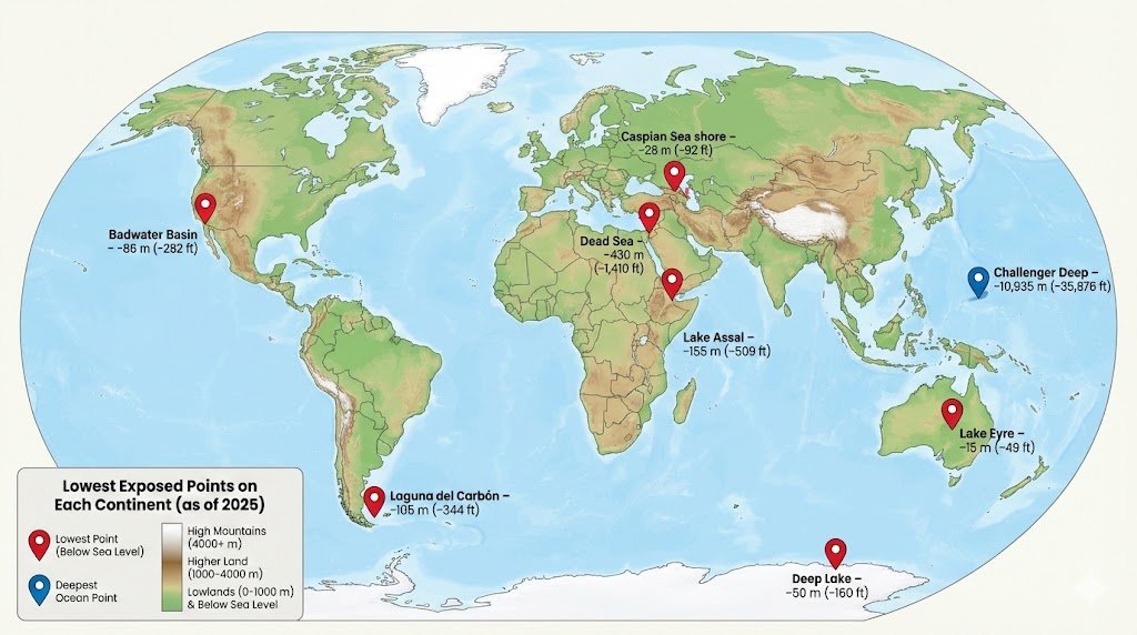
What’s the lowest land point on any continent?
The shoreline of the Dead Sea is commonly cited as Earth’s lowest exposed land elevation, at roughly −1,410 ft (−430 m) below sea level. The exact level changes over time as the lake level changes.
What Did We Learn Today?
- “Continent” is partly a convention: seven is common, but 6- and 5-continent models also exist.
- Geography and geology draw lines for different reasons; continental crust and shelves complicate borders.
- Europe–Asia boundaries are conventional reference lines, not a single physical “wall.”
- Continents and tectonic plates are different systems: one is cultural/map-based, the other is geophysical.
- Zealandia shows how a geologic definition can produce different—but internally consistent—groupings.
Continents organize how we tell human stories and how we read Earth’s surface. Knowing both perspectives—cultural and scientific—helps you interpret maps, news, and the planet’s long, moving history.
Sources & Data Notes
Primary references used or linked in this article include: Britannica (continent definition and models), Britannica (Suez Canal length), Panama Canal Authority (isthmus context), GSA Today (Zealandia), and Britannica pages for major peaks (Everest, Denali, Aconcagua, Elbrus, Vinson).