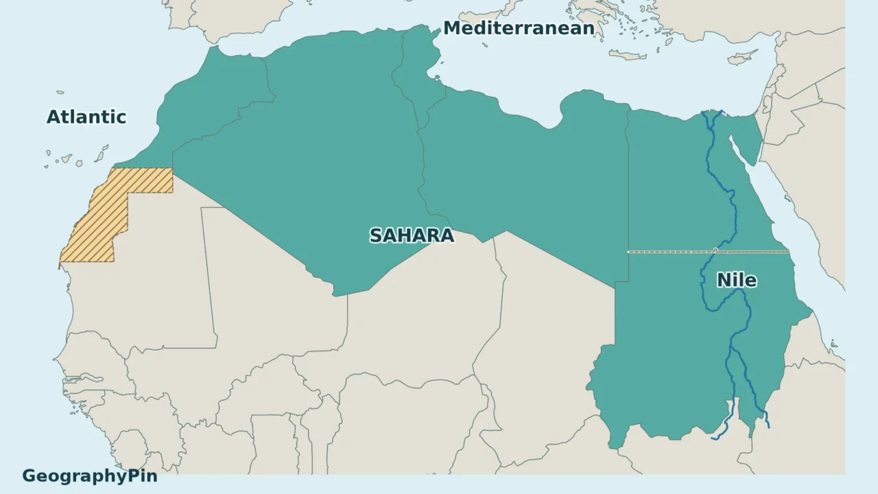
North Africa can mean a statistical region, the lands along Africa’s northern edge, or a broad cultural region. The Maghreb overlaps with it, but the two names do not produce the same country list.
Using the UN’s Northern Africa classification, the six sovereign countries are Algeria, Egypt, Libya, Morocco, Sudan and Tunisia. The UN also lists Western Sahara separately in this region. For a precise Maghreb comparison, the five Arab Maghreb Union states include Mauritania, but not Egypt or Sudan.
How to use this article: Check the counting convention, compare Maghreb membership, or follow the Nile corridor.
1. North Africa on the map: what the numbers mean
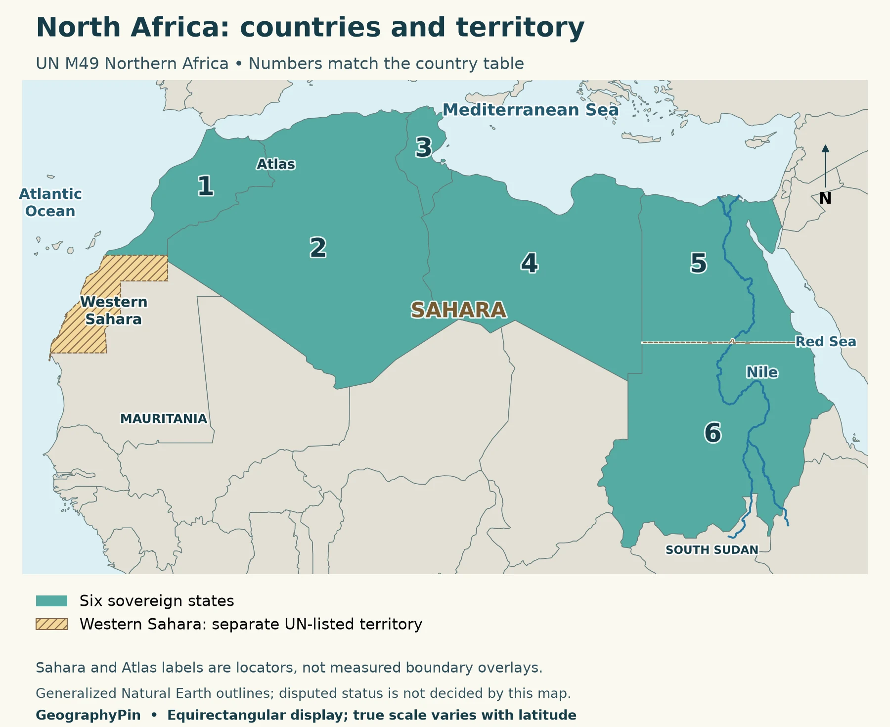
| Number and country | Geographic orientation |
|---|---|
| 1. Morocco | Northwestern corner; Atlantic and Mediterranean coasts. |
| 2. Algeria | Between Morocco and Tunisia/Libya; extends from the Mediterranean far into the Sahara. |
| 3. Tunisia | Small Mediterranean country between Algeria and Libya. |
| 4. Libya | Mediterranean coast between Tunisia and Egypt; desert interior to the south. |
| 5. Egypt | Northeastern corner; Nile valley, Mediterranean and Red Sea coasts. |
| 6. Sudan | South of Egypt; Nile corridor and a Red Sea coast. |
The counting convention
The United Nations Statistics Division’s M49 system calls this subregion Northern Africa. It lists “countries or areas,” so counting its entries is not the same as counting independent states. There are seven entries here: the six countries in the table and Western Sahara.
This is a statistical grouping, not a declaration that every historical, cultural or environmental definition of North Africa must use these borders. It also does not settle territorial disputes. That distinction matters whenever a map, textbook or country list gives a different total.
For a continent-wide directory and printable regional sheets, use the Africa countries map. Here the emphasis is on explaining why the regional groupings differ and how the land and water fit together.
2. North Africa and the Maghreb are not the same region
A clear five-member Maghreb comparison
The Maghreb is the western part of the broader North African world, but its scope varies with context. A precise institutional comparison is the Arab Maghreb Union’s five member states: Algeria, Libya, Mauritania, Morocco and Tunisia. This is the grouping used in the comparison map below; it is not a claim that all geographic or cultural uses of “Maghreb” have one fixed boundary.
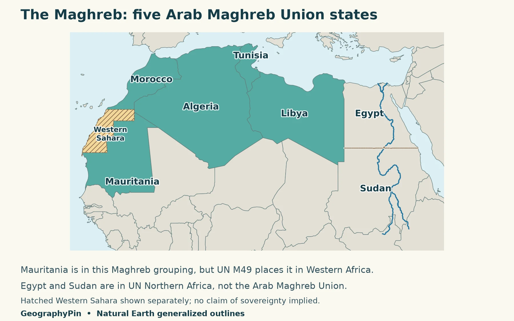
| Place | UN M49 subregion | Arab Maghreb Union |
|---|---|---|
| Algeria, Libya, Morocco, Tunisia | Northern Africa | Members |
| Egypt and Sudan | Northern Africa | Not members |
| Mauritania | Western Africa | Member |
| Western Sahara | Northern Africa, separate area | Not one of the five member states |
Mauritania is the most useful test case. Including it in a Maghreb map does not make the UN list wrong: the maps are answering different questions. One shows a specific organization’s membership; the other shows a statistical regional classification.
Sudan is not South Sudan
UN M49 places Sudan in Northern Africa and South Sudan in Eastern Africa. They are separate countries, not interchangeable names for the same entry. A North Africa map that includes Sudan should not automatically shade South Sudan too.
The regional choice does not mean every part of Sudan resembles Mediterranean coastal North Africa. A statistical region can span different landscapes. Country membership tells you which list to use; it does not supply a climate map or a uniform cultural description.
3. Why Western Sahara is shown separately
Western Sahara appears as its own entry in UN M49 Northern Africa. It is also on the UN list of Non-Self-Governing Territories, and its final status remains unresolved. The UN General Assembly’s Western Sahara resolution addresses a political solution that provides for self-determination.
For that reason, this map uses a separate hatch across Western Sahara rather than quietly giving it Morocco’s country fill or presenting it as an uncontested seventh independent country. A reader can see both its regional inclusion and the reason it is counted differently.
The map is not a current-control map. It does not attempt to trace the berm, show military positions, count diplomatic recognition or resolve competing claims. Those are different questions that require a more detailed, specifically dated treatment. Generalized boundaries elsewhere on the map should likewise not be read as a legal judgment.
4. Read the region through its coast, mountains and rivers
Three physical patterns make the regional map easier to understand: a northern Mediterranean frontage, the broad Sahara inland, and the Nile running through the northeast. They cut across the political country list rather than neatly reproducing it.
Mediterranean coast and Atlas mountains
Morocco, Algeria, Tunisia, Libya and Egypt meet the Mediterranean. Morocco also faces the Atlantic; Sudan’s coast is on the Red Sea rather than the Mediterranean. These coastlines explain why a simple “Mediterranean countries of Africa” list leaves out Sudan even though UN M49 includes it in Northern Africa.
The Atlas Mountains run across the northwest, from Morocco through Algeria into Tunisia. They are a mountain system, not a line marking the official southern edge of North Africa. Their position helps explain why the northwest should not be pictured as one uninterrupted desert plain. The Algeria country profile explores one of the countries spanning this coastal-to-interior transition.
The Sahara is not a synonym for North Africa
The Sahara occupies a broad belt across northern Africa, but “Sahara” names a desert, while “Northern Africa” here names a UN statistical subregion. Neither should be used as a substitute for the other. The desert extends into countries assigned to other UN subregions, and North Africa includes coasts, mountains and the Nile corridor as well as desert.
The Sahara label on the map is therefore a locator, not a colored boundary layer. No exact desert edge, rainfall threshold or desert-area percentage is implied. Such boundaries need their own climatic or ecological definition and dataset.
The Nile corridor through Sudan and Egypt
The Nile runs north through Sudan and Egypt toward the Mediterranean. Its route is a useful reminder that rivers do not have to flow south: water follows the downhill path, regardless of compass direction. The pronounced bend in northern Sudan is part of the river’s mapped course, not a cartographic error.
In the northern Nile valley, the river supports a narrow agricultural corridor through surrounding desert. This contrast is visible in satellite imagery and explains why a broad desert label alone gives an incomplete picture of northeastern Africa. For the river’s wider route and context, see the Nile River guide.
Frequently Asked Questions
Is North Africa the same as MENA?
No. MENA combines Middle East and North Africa, so it extends beyond Africa. The exact membership depends on the organization using the term; it is not another name for the seven UN M49 Northern Africa entries.
Does Egypt’s Sinai Peninsula change its regional classification?
No. Sinai lies in southwest Asia, but the M49 country classification places Egypt in Northern Africa. A country-level statistical grouping and the continental position of part of its territory answer different questions.
Can I use this map to measure distances?
Not precisely. It is a generalized regional reference map, with scale varying by latitude. Use an appropriate distance tool or a suitable projected map for measurements; the country numbers are location keys, not coordinates.
What Did We Learn Today?
A useful North Africa map needs a stated convention. UN Northern Africa, the Maghreb and the Sahara describe different things: a statistical subregion, an overlapping regional idea or institutional grouping, and a desert. Separating those meanings clarifies Mauritania’s inclusion in the Maghreb, Sudan’s UN placement and Western Sahara’s distinct status, while the Atlas and Nile explain the region beyond its country borders.
Sources & Data Notes
Country grouping follows UN M49 Northern Africa; the Maghreb comparison uses the Arab Maghreb Union’s five members. Maps use generalized Natural Earth country, disputed-area and river data. The Natural Earth disputed-area outline of Western Sahara is hatched separately; no current control line is shown. The dashed Egypt–Sudan boundary is generalized and does not resolve disputed areas. Sahara and Atlas labels are broad locators, not measured boundary layers. Classification and status sources were consulted in November 2026.