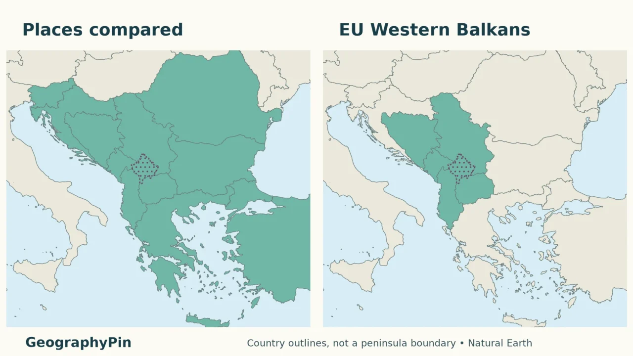
A Balkan countries map is only useful when its legend explains what “Balkan” means. A map of the peninsula, a regional country list and an EU policy map can show different areas without one necessarily being wrong.
Balkan country lists differ because the geographic peninsula, the broader historical region and the EU’s Western Balkans grouping are not identical. Northern limits vary, several countries are only partly on the peninsula, and Kosovo requires a status note. There is no single universally accepted total for all uses of “the Balkans.”
How to use this article: Compare the country inclusion rules, follow the northern river convention, or check Kosovo’s status note.
1. Find each country and compare the definitions
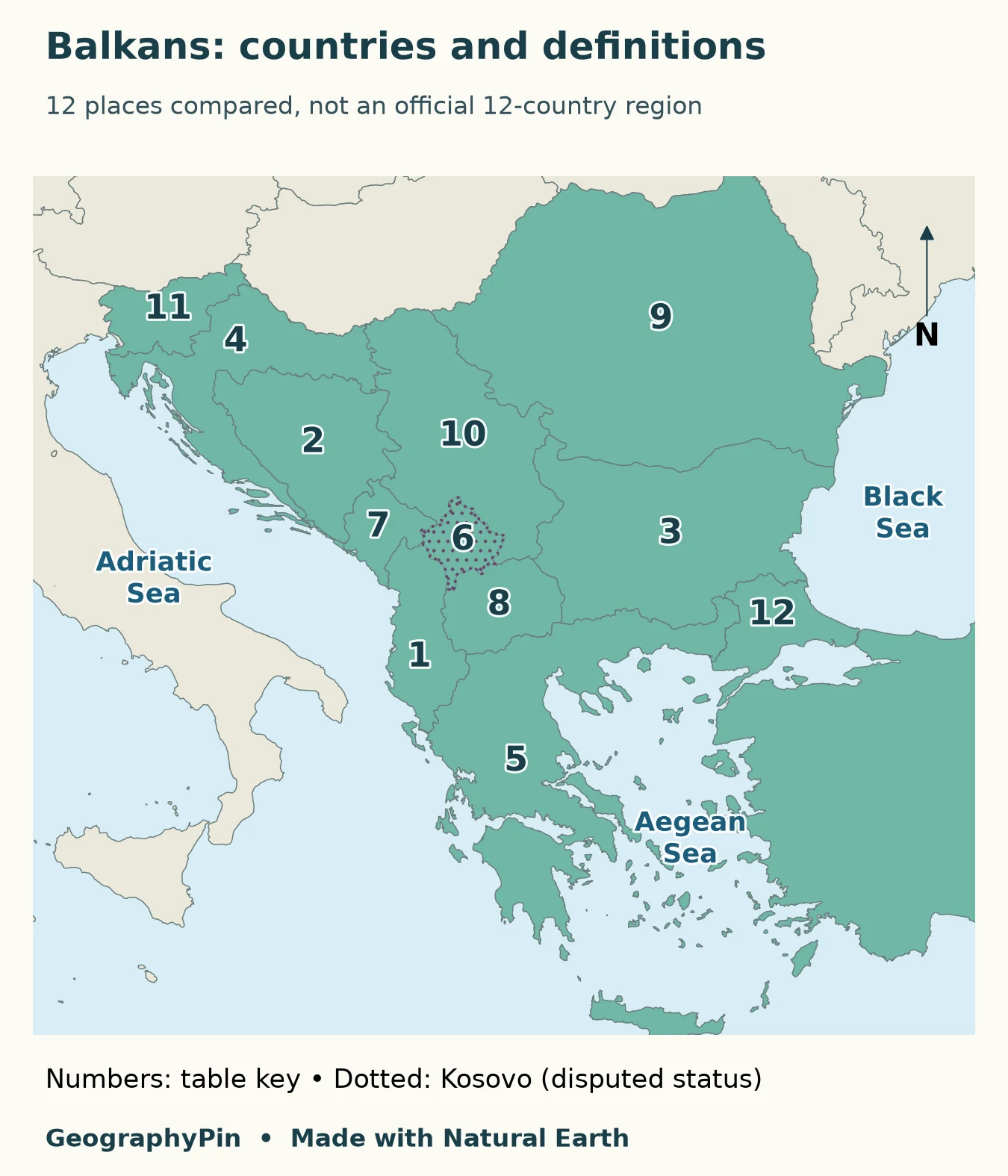
The numbers identify the twelve entries discussed below, not twelve universally agreed Balkan states. Whole-country outlines are used for orientation; they do not mean that every part of a colored country belongs to the peninsula.
Country-by-country inclusion rules
The peninsula column uses the common northern-river approach, with its uncertain northwestern extension stated rather than hidden. The final column follows the EU Council’s six-partner Western Balkans grouping. “No” means outside that policy grouping, not outside southeastern Europe.
| Map entry | Geographic peninsula | EU Western Balkans |
|---|---|---|
| 1. Albania | Within | Yes |
| 2. Bosnia and Herzegovina | Within | Yes |
| 3. Bulgaria | Within | No |
| 4. Croatia | Part; northern limit depends on convention | No |
| 5. Greece | Mainland within; islands are not the peninsula | No |
| 6. Kosovo | Within; status disputed | Yes |
| 7. Montenegro | Within | Yes |
| 8. North Macedonia | Within | Yes |
| 9. Romania | Part: Northern Dobruja | No |
| 10. Serbia | Part: south of the Sava–Danube line | Yes |
| 11. Slovenia | Depends on northwestern boundary | No |
| 12. Turkey (Türkiye) | Part: East Thrace, not Anatolia | No |
For a country-level view of the western coast, see the Albania country profile. For the wider continental frame, use the Europe country maps, whose statistical counting rule serves a different purpose.
2. Where does the Balkan Peninsula begin?
The northern river convention
The Adriatic, Ionian, Aegean and Black Sea sides are easier to recognize than the peninsula’s northern edge. There is no single narrow neck separating it from the rest of Europe. Károly Kocsis’s geographical study identifies the Danube, Sava and Kupa as a commonly used northern convention, while documenting alternatives around Slovenia and Croatia.
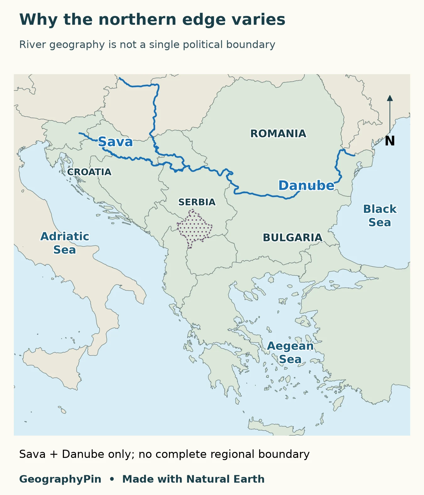
A river-based definition cuts across countries rather than following all their borders. That is why a national outline and a peninsula outline cannot be treated as interchangeable. Shading all of Serbia, Croatia or Romania as if each were entirely inside the physical peninsula would conceal the very distinction the map needs to explain.
How to read the partial cases
Romania illustrates the problem particularly clearly: Northern Dobruja belongs in the peninsula comparison, but that does not bring the whole country into the same physical area. Turkey presents a different split. East Thrace lies on the European side; the much larger Anatolian part is not part of the Balkan Peninsula.
Greece needs a mainland-versus-islands distinction rather than a north–south country split. A country can be described as Balkan and Mediterranean without those descriptions competing. Similarly, Slovenia’s treatment changes with the chosen northwestern line. The right response is to identify the convention, not silently turn an uncertain edge into a precise border.
3. The Western Balkans are a policy grouping
The EU Council’s Western Balkans grouping comprises Albania, Bosnia and Herzegovina, Kosovo, Montenegro, North Macedonia and Serbia. It describes six partners in the EU’s regional relationship, not a test of which land lies west of the peninsula’s midpoint.
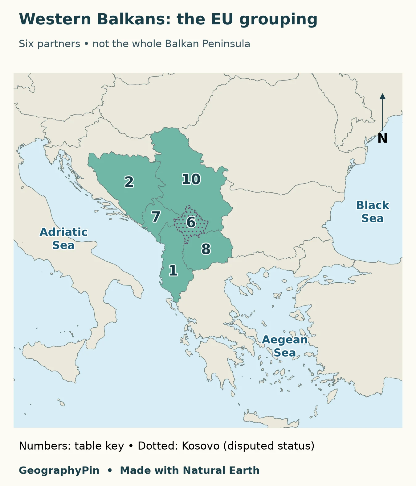
Reading the two maps together is more useful than memorizing one total. Bulgaria and mainland Greece belong in the peninsula discussion but are not in this six-partner grouping. Serbia is included as a partner even though its national territory extends beyond the commonly used river line. Membership and physical extent answer different questions.
Why Kosovo is shown separately
Kosovo declared independence in 2008. Serbia does not recognize that independence, and international recognition is not universal. The House of Commons Library’s account of Kosovo–Serbia relations explains this distinction.
The EU uses a status-neutral caveat with the Kosovo designation. Showing Kosovo separately here makes the location and EU comparison legible; it is not a statement that every government recognizes the same sovereign-state list. A count should say whether it counts states, partners or separately displayed territories.
4. Why a regional label is not a country count
Historical and political writing may use “the Balkans” more broadly than a physical peninsula map. Such a regional label can include whole countries for the purpose of comparing their history or institutions. It should not be mistaken for a survey of which square mile lies south of a river.
Nor is “Balkans” a synonym for the UN’s Eastern Europe category. UN M49 places countries into statistical subregions for data organization; it does not supply a Balkan membership list. Switching from one framework to another midway through a table produces misleading totals even when every individual country name is correct.
A three-question check for any Balkan list
- What is being classified? Land on a peninsula, whole countries in a regional discussion, or partners in an institution?
- What rule is used at the edges? Look for treatment of northern Croatia and Serbia, Slovenia, Romania, Greek islands and Turkey’s European portion.
- How is political status handled? Kosovo’s separate display needs an explanation, especially when a headline promises a country count.
If those answers are missing, use the list as an introduction, not a definitive classification. A useful legend explains the author’s choice before the reader has to guess it.
Frequently Asked Questions
Are the Balkan Mountains the same as the Balkan Peninsula?
No. The Balkan Mountains are a mountain range; the Balkan Peninsula is the much larger geographic region discussed here. The peninsula takes its name from the mountains, but its extent is not defined by the extent of that range.
Which definition should I use for a school assignment?
Use the convention specified by the assignment or textbook, and name it in your answer. If none is given, explain your inclusion rule and identify partial-country cases instead of presenting a bare total.
What Did We Learn Today?
The most useful Balkan map is not the one with the longest list, but the one that explains its boundaries. Comparing a peninsula convention with an institutional grouping reveals why whole-country shading can mislead, why edge cases need notes, and why a map’s separate entries do not automatically equal a universally recognized state count.
Sources & Data Notes
The peninsula comparison uses a common northern-river convention while retaining uncertainty at its northwestern end. The EU grouping was checked in November 2026. Maps use generalized Natural Earth outlines and river data; whole-country categories are not measured peninsula extents. Kosovo is separately displayed with a status caveat. No population, land-area percentage or universal Balkan country total is inferred.
- Károly Kocsis: The Concept and Boundaries of South Eastern Europe and the Balkans
- Nations Online: Balkan Peninsula geographic reference
- Council of the EU: Western Balkans partners and status caveat
- House of Commons Library: Kosovo’s declaration and relations with Serbia
- UN Statistics Division: M49 regional classification
- Natural Earth: public-domain map data and reuse terms