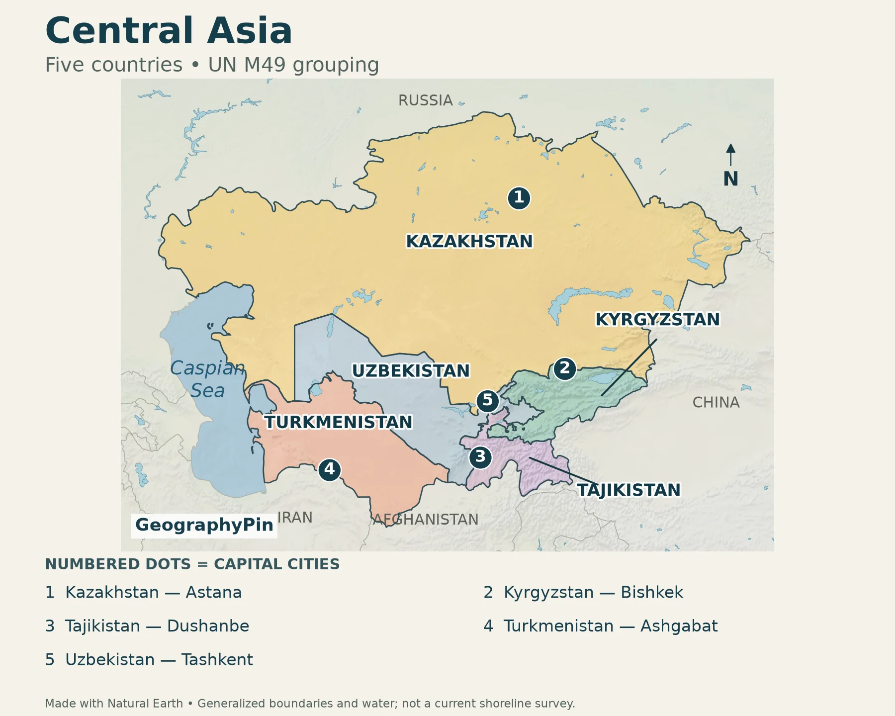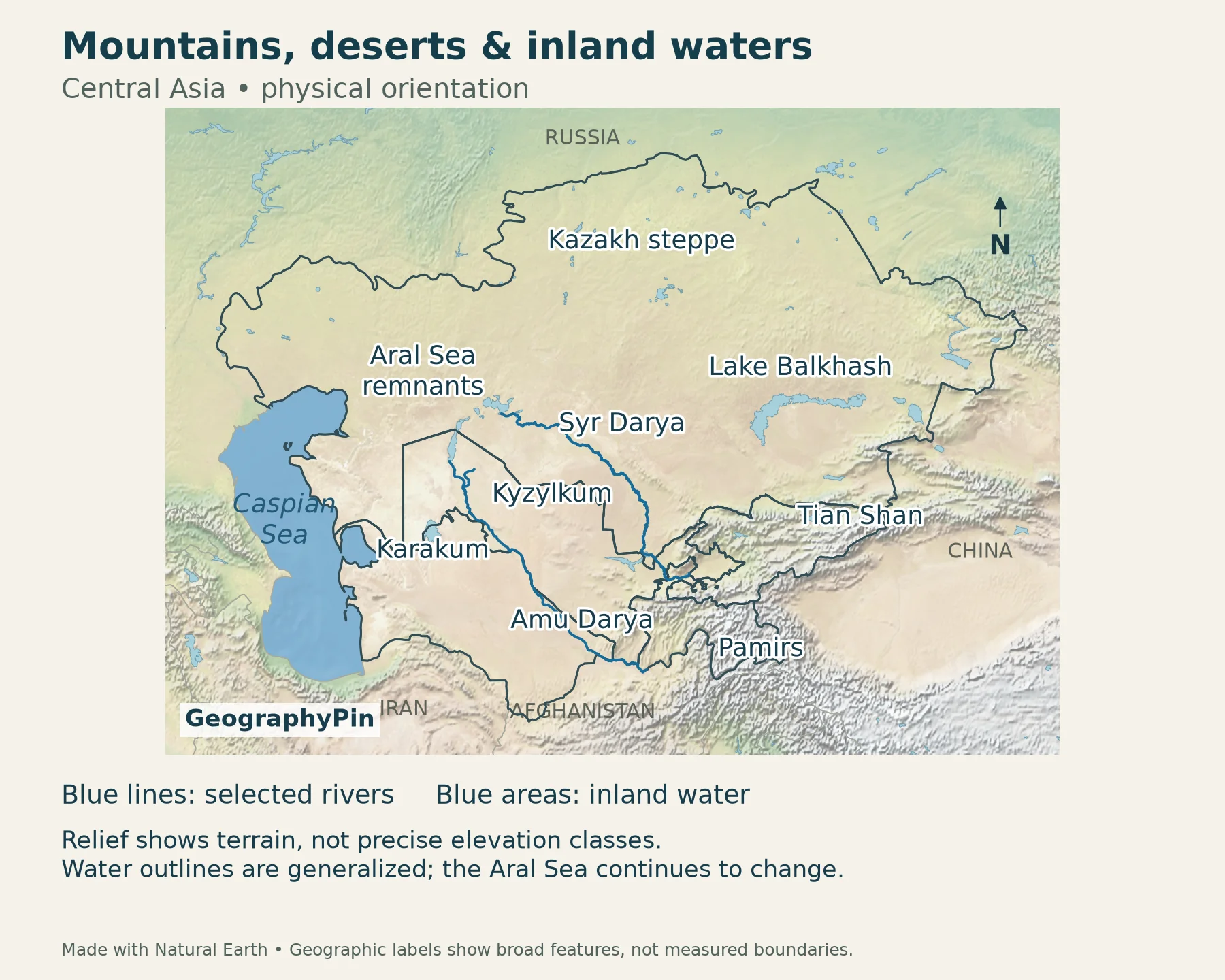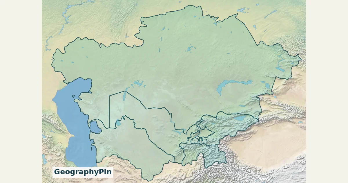
Central Asia has five countries under the UN’s M49 statistical grouping: Kazakhstan, Kyrgyzstan, Tajikistan, Turkmenistan and Uzbekistan. They form a landlocked region between Russia, China, Afghanistan, Iran and the Caspian Sea. This map locates the five states and their capitals, with a separate view of the mountains, deserts and inland waters.
Start with the country map and its capital key. Then use the physical map to see why neighboring places can have very different landscapes. This guide follows one explicit five-country convention; it does not treat every historical use of “Central Asia” as having identical borders.
1. Central Asia map: what counts as the region?

The UN Statistics Division’s M49 list places all five countries in Central Asia. It is a statistical classification, not a claim that a region’s cultural or physical boundaries can be drawn only one way.
Read the map from north to south. Kazakhstan occupies the broad northern part of the group. Uzbekistan lies below it and meets all four other Central Asian states. Turkmenistan is to the southwest, while Kyrgyzstan and Tajikistan occupy the mountainous eastern and southeastern parts. The surrounding countries are shown for orientation, not included in the count.
Historical and cultural discussions can use “Central Asia” more broadly than a modern country list. That does not make a five-country map wrong: it means the map needs to state what it counts. For the larger continental picture, see Asia’s countries and capitals.
2. The five countries and their capitals
| No. | Country | Capital | Map orientation |
|---|---|---|---|
| 1 | Kazakhstan | Astana | Northern span of the region; stretches from the Caspian to China. |
| 2 | Kyrgyzstan | Bishkek | South of Kazakhstan, with the Tian Shan across much of its territory. |
| 3 | Tajikistan | Dushanbe | Southeastern part of the group; the Pamirs rise in its east. |
| 4 | Turkmenistan | Ashgabat | Between the Caspian Sea, Iran, Afghanistan and Uzbekistan. |
| 5 | Uzbekistan | Tashkent | Meets the other four states and Afghanistan; no Caspian coast. |
The capitals are not evenly spaced. Astana is well north of the other four; Bishkek and Tashkent sit toward their countries’ northern edges. Dushanbe is in western Tajikistan rather than in the high eastern Pamirs. Ashgabat lies close to Turkmenistan’s southern border. These placements are easier to remember than a disconnected list of names.
Use Astana for Kazakhstan’s current capital. Older maps may label the same city Nur-Sultan. Our Astana guide explains the capital’s name changes and the move from Almaty.
3. Mountains, deserts and the steppe

Open the physical map at full size
A country map alone can make Central Asia look like one uniform interior. The relief map shows a different pattern: broad lowlands and plateaux give way to rugged mountain systems toward the southeast.
The Kazakh steppe is a broad grassland belt across northern Kazakhstan, not a synonym for the whole country. Farther south and west, dry landscapes include the Karakum in Turkmenistan and the Kyzylkum, largely in Uzbekistan and Kazakhstan. A desert label on this regional map locates a broad landscape; it is not a surveyed boundary or a claim that every nearby valley is desert.
The Tian Shan is a major mountain system extending through Kyrgyzstan and neighboring countries. UNESCO’s Western Tien-Shan site spans Kazakhstan, Kyrgyzstan and Uzbekistan. The Pamirs form a separate high-mountain landmark farther south, especially in eastern Tajikistan. Do not use the two names interchangeably.
This contrast helps explain why regional water discussions connect uplands and lowlands. Snow and ice stored in mountains contribute to river flow, while downstream water supports settlements and irrigated land. Country borders do not divide these natural systems into self-contained units.
4. Inland waters and river connections
Landlocked does not mean waterless. Kazakhstan and Turkmenistan have Caspian coastlines, yet neither has a coastline on the world ocean. The Caspian is an enclosed inland water body. Uzbekistan, Kyrgyzstan and Tajikistan have no Caspian frontage.
The Amu Darya and Syr Darya are central to the Aral Sea basin. Historically, the two river systems supplied the large inland lake between Kazakhstan and Uzbekistan. Diversions for irrigation sharply reduced inflow, and the lake contracted into separated remnants. NASA’s satellite-based account makes the important distinction between the former broad water surface and today’s mixture of remaining water and exposed lakebed.
That is why a regional map should not present a single old Aral Sea outline as today’s shoreline. Water levels and the extent of the remaining basins vary. The map here locates the system; it is not a measurement of current water coverage or a guarantee that every drawn lower river reach carries water continuously.
Nor should “Central Asia” be treated as the name of one drainage basin. Its countries extend across several river and lake systems. A political region is defined by membership, whereas a drainage basin is defined by where water flows.
Uzbekistan adds another useful distinction: it is doubly landlocked, meaning all its neighboring countries are landlocked too. The World Bank’s country overview confirms both that status and its borders with the four other Central Asian states. For the global definition, see which countries are landlocked.
5. Why Kazakhstan can be Central Asian and transcontinental
Kazakhstan’s placement in Central Asia does not require every part of its territory to lie east of every conventional Europe–Asia dividing line. Under the commonly used Ural River convention, a western portion lies in Europe and most of the country lies in Asia.
These are different kinds of classification. The continental boundary is a geographic convention; the M49 list assigns the country as a whole to a statistical subregion. This guide therefore counts Kazakhstan once, in full, among the five Central Asian states. It does not add or subtract a country when the continental dividing line is discussed.
Frequently Asked Questions
Is Afghanistan one of the five Central Asian countries?
Not under the UN M49 convention used here: Afghanistan is grouped in Southern Asia. It can still appear in broader historical discussions of Central Asia. Read the map’s definition before comparing country counts.
Is Mongolia included in this Central Asia map?
Mongolia is not one of the five highlighted countries. UN M49 places it in Eastern Asia. Regional and historical terminology is not always identical, so a different map may use a broader scope.
What Did We Learn Today?
Central Asia becomes easier to read when political membership, terrain and drainage are kept separate. The five-state grouping provides a clear country count; mountains, deserts and river systems explain the landscape without fitting neatly inside those borders. Kazakhstan’s continental position and the Caspian coastline illustrate why a regional label alone cannot answer every geographic question.
Sources & Data Notes
Country membership follows UN M49. Original GeographyPin maps combine Natural Earth’s public-domain country boundaries, populated-place points, rivers, lakes and shaded relief. The older capital label Nur-Sultan is updated to Astana. Borders are generalized at regional scale; small enclaves and recent local boundary adjustments are not resolved here. Water outlines, particularly the changing Aral Sea, are not contemporary measurements. Terrain colors do not represent fixed elevation thresholds.
- UN Statistics Division: M49 regional classification
- World Bank: Uzbekistan overview
- UNESCO: Western Tien-Shan
- UNESCO: Tajik National Park and the Pamirs
- NASA Earth Observatory: Dunes and Desert Replace the Aral Sea
- Kazakhstan country profile: continental location
- World Bank: Central Asia’s mountain-fed water systems
- UNESCO: Saryarka, steppe and lakes of northern Kazakhstan
- Regional Strategy for Sand and Dust Storms Management in Central Asia 2021–2030
- Natural Earth: public-domain map data