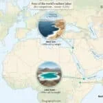
The Caspian Sea sits between the Caucasus and Central Asia and touches Russia, Kazakhstan, Turkmenistan, Iran, and Azerbaijan. It behaves like a lake, is called a sea, and keeps changing shape as water levels rise and fall, which is exactly why it matters physically, economically, and politically.
The Caspian Sea is the largest lake in the world by surface area. Even though it is called a sea, it is a landlocked, brackish basin with no natural outlet to the ocean, so in physical geography it is classified as a lake while the historic name remains in use.
How to use this article: Need the classification issue first? Go to why it is called a sea; want the fast numbers? Jump to why the size figure moves; checking hydrology? Use why the Volga matters; or skip straight to what the 2018 convention actually set.
What the Caspian Sea actually is
The Caspian is a vast inland water body, not an arm of the world ocean. It lies east of the Caucasus Mountains and west of the Central Asian steppe, and its defining physical trait is that it is endorheic: water flows in, but there is no natural outlet flowing back out to the sea. That alone places it in the lake category from a hydrological point of view.
Why it is called a sea if it is a lake
The word “sea” survives because the Caspian is huge, mildly salty, historically important for navigation, and treated in regional politics as something more complex than a normal inland lake. In other words, its name reflects history and scale, while its scientific classification reflects how water moves through the basin.
Size, depth, and salinity
A widely used reference figure gives the Caspian a surface area of about 149,200 square miles (386,400 square kilometers). It stretches nearly 750 miles (1,200 kilometers) from north to south, averages about 200 miles (320 kilometers) wide, and reaches a maximum depth of roughly 3,360 feet (1,025 meters) in the south. Average salinity is about 12.8 parts per thousand, well below typical ocean water.
Why the size figure moves
You will also see a lower area figure of about 143,200 square miles (371,000 square kilometers) in many references. That does not mean one source is automatically wrong. The safer reading is that the Caspian’s shoreline shifts with water level, and some references are describing different time frames or shoreline states rather than a permanently fixed outline.
| Metric | Value |
|---|---|
| Surface area | About 149,200 sq mi (386,400 km²), with lower figures also used when water levels differ |
| Length | Nearly 750 mi (1,200 km) |
| Average width | About 200 mi (320 km) |
| Maximum depth | About 3,360 ft (1,025 m) |
| Average salinity | About 12.8‰, with much fresher water near the Volga mouth and much saltier water in Kara-Bogaz-Gol |
| Natural outlet | None |
Figures are rounded to keep the comparison readable and to avoid fake precision where the shoreline itself is changing.
How the Caspian works: rivers, evaporation, and basins
The Caspian has no natural outlet, so its long-term balance depends on what flows in versus what evaporates away. Rivers do the feeding, evaporation does the draining, and that balance is what makes the water level rise or fall over time rather than staying fixed like a reservoir behind a controlled dam.
Why the Volga matters
The Volga is the dominant river in this system. ESA notes that it supplies about 80% of the Caspian’s freshwater inflow, which is why the northern Caspian is much fresher and shallower than the south. When the Volga changes, the whole basin feels it.
Why the north and south feel so different
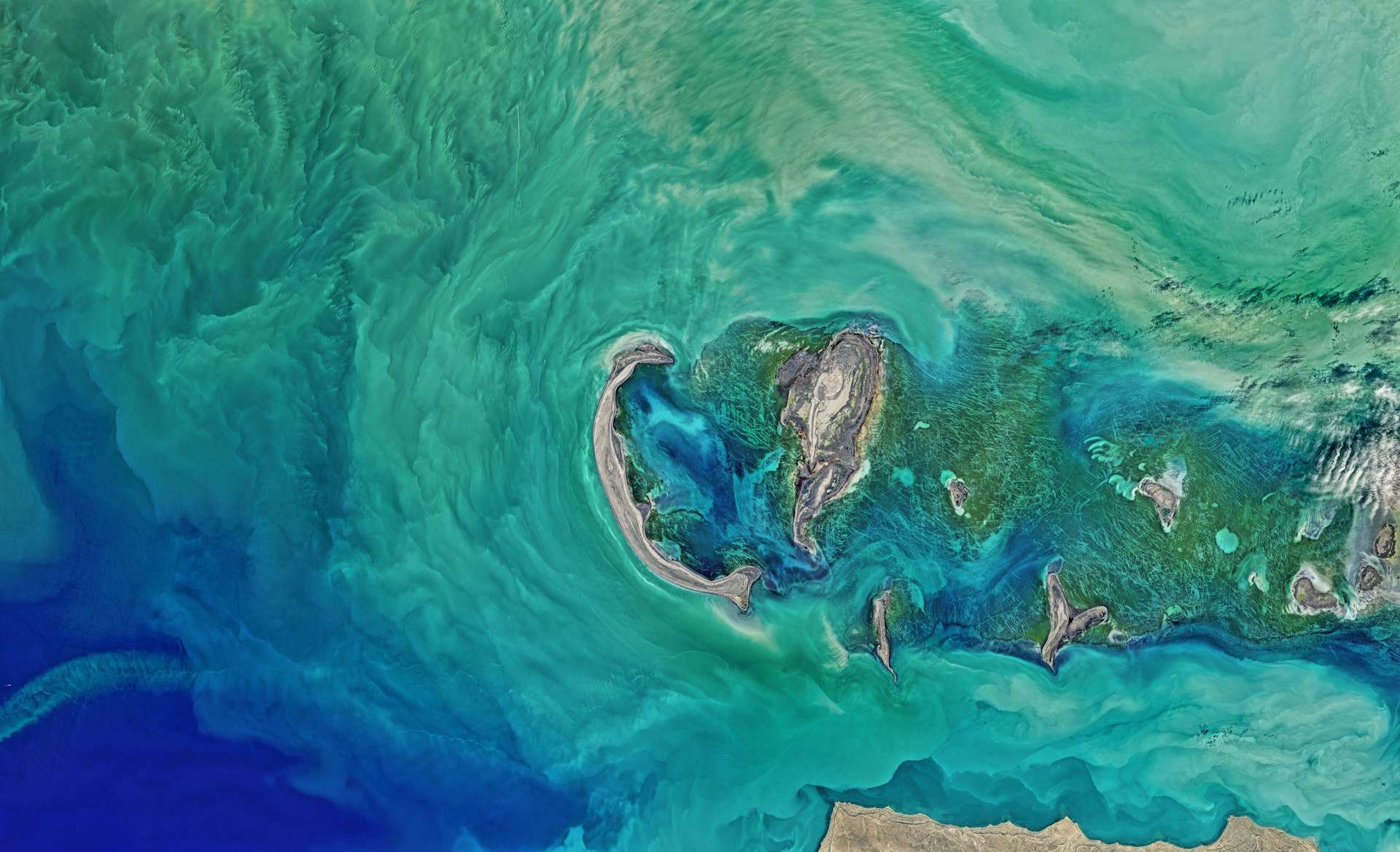
Geographers commonly divide the Caspian into North, Middle, and South basins. The north is extremely shallow and can freeze in winter; the south holds the greatest depth and volume. That uneven structure explains why one end of the basin behaves almost like a giant delta-lake while the other looks and functions much more like a deep inland sea.
Wildlife, fisheries, and conservation pressure
The Caspian seal is the basin’s only endemic marine mammal, and its conservation status is serious. IUCN reporting notes that the species has been listed as Endangered, with concerns tied to habitat stress, pollution, bycatch, and the broader environmental changes affecting the sea’s northern breeding areas.
Sturgeon are just as central to the Caspian story. They helped make the basin famous for caviar, but overfishing, illegal harvest, river disruption, and pollution drove major declines. That is why Caspian sturgeon management is not just a fisheries issue; it is a long-running conservation and governance problem shared across borders.
Ports, energy, and regional importance
The Caspian matters because it is not only a physical-geography topic. It is also an economic basin shaped by offshore oil and gas, fisheries, coastal industry, and shipping. That is one reason places such as Baku have long been tied to the sea’s commercial value and energy history.
Even though it is landlocked, the Caspian is not completely cut off from wider navigation. Through the Volga system, the Volga–Don Canal provides access toward the Sea of Azov and Black Sea, while the Volga–Baltic Waterway links the Volga to the Baltic network. So the Caspian sits inland, but it still connects into a much larger transport geography.
Law and borders: why it is treated differently
For years, one of the hardest Caspian questions was whether to treat it legally as a sea or a lake. The five littoral states moved toward a tailored answer in 2018, when they signed the Convention on the Legal Status of the Caspian Sea, a special regime built around the basin’s unusual geography rather than a simple copy-and-paste from normal ocean law.
What the 2018 convention actually set
The convention established territorial waters up to 15 nautical miles (17.3 miles or 28 kilometers) and an adjacent 10 nautical mile (11.5 mile or 19 kilometer) exclusive fishery zone for each state. It also confirmed that some questions, especially around delimitation and resource use, still depend on agreements between neighboring states rather than one single all-purpose boundary line.
Shrinking shorelines and climate risk
The Caspian is not only variable in the long historical sense; it is under modern pressure too. Britannica notes that after the late twentieth-century rebound, the sea stood relatively high in the mid-1990s, but the broader recent picture has again been one of decline. UNEP’s Tehran Convention material also shows that water-level fall has become a major regional policy concern.
The exact long-range drop is not settled to one single number, and it is better not to pretend otherwise. NASA explainers summarize published estimates ranging from about 9 to 18 meters (30 to 59 feet) by 2100 in one widely cited scenario, while other model-based ranges go higher. The safe conclusion is that substantial decline is plausible, with serious consequences for wetlands, ports, fisheries, and northern habitat.
FAQ
Is the Caspian Sea a sea or a lake?
Hydrologically, it is a lake because it is landlocked and has no natural outlet to the ocean. Legally and politically, it is governed by a special regime created by the 2018 convention, which is why simple labels do not tell the whole story.
Why is it called the largest lake if the water is salty?
Salinity does not turn a landlocked basin into an ocean. The Caspian is mildly salty on average, but because it has no natural outlet and functions as an inland basin, it is still classified as a lake in physical geography.
Which countries border the Caspian Sea?
Russia, Kazakhstan, Turkmenistan, Iran, and Azerbaijan. Those five states are the littoral countries that share the basin and its legal framework.
Does the Caspian stay the same size?
No. Its shoreline moves as the balance between river inflow and evaporation changes. That is why different references can show slightly different area figures without necessarily contradicting each other.
Can ships reach other seas from the Caspian?
Yes, through inland waterway links. The Volga–Don Canal connects toward the Sea of Azov and Black Sea system, and the Volga–Baltic Waterway links the Volga to the Baltic network.
Why is the recent water-level decline such a big issue?
Because even a moderate long-term fall can redraw coasts, complicate port access, damage wetlands, and squeeze habitats that already face ecological pressure. The main point is not one perfect forecast number; it is that the risk is large enough to matter now.
What Did We Learn Today?
The Caspian Sea is best understood as a huge landlocked lake whose scale, salinity, and political importance make the word sea feel natural even if the hydrology says otherwise. Its moving shoreline, Volga-driven water balance, special legal status, and mounting ecological stress all point to the same conclusion: this is not a static map feature but a changing inland system with real consequences for the five states around it.
Sources & Data Notes
For this upgrade, I leaned mainly on standard reference material such as Encyclopædia Britannica for baseline geography and dimensions, ESA and NASA explainers for hydrology and shoreline-change context, UNEP’s Tehran Convention material for current water-level concern, and the text of the 2018 convention for the legal framework. Figures are rounded where that is the safer editorial choice, and newer releases can shift some details, especially where water level and ecology are concerned. Some wording support and some GeographyPin visuals may be AI-assisted, but the final trimming, structure, and editorial judgment are still handled manually in my voice.