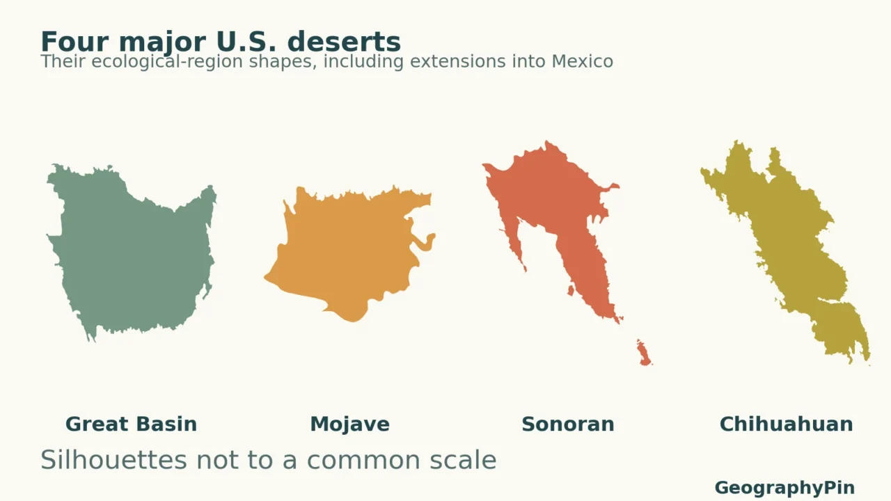
Four familiar desert names organize much of the dry American Southwest, but their landscapes and rainfall seasons are far from interchangeable. The clearest comparison follows the regions into Mexico, separates ecological boundaries from watersheds, and uses the same climate period rather than mixing unrelated weather averages.
The four major deserts conventionally identified in the southwestern United States are the Great Basin, Mojave, Sonoran and Chihuahuan. They differ in winter cold, elevation, rainfall season and vegetation. Sonoran and Chihuahuan landscapes continue into Mexico. Their mapped boundaries depend on the ecological or climatic definition used, not simply on state borders.
How to use this article: Check the map’s scope, compare same-period climate examples, or separate the desert from the drainage basin.
1. U.S. deserts map: what the four-region view includes
Read the regions across the international border
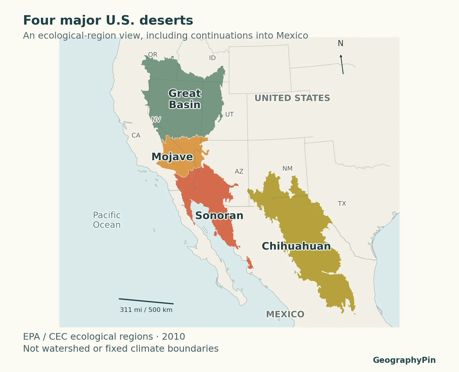
The conventional four major deserts of the southwestern United States are the Great Basin, Mojave, Sonoran and Chihuahuan. This is a useful regional framework, not an assertion that the country contains only four places with dry conditions. Smaller named deserts can be subdivisions, local landscapes or regions defined under a different classification.

The Great Basin occupies the northern part of this comparison, the Mojave lies southwest of it, the Sonoran extends farther south through Arizona and northwestern Mexico, and the Chihuahuan lies to the southeast through New Mexico, western Texas and Mexico. The international border crosses desert landscapes; it does not mark their southern edge.
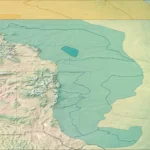
The colored outlines describe ecological regions, not a measured rainfall threshold. An ecological region combines several characteristics, such as climate, vegetation, terrain and soils. A line on a small-scale map simplifies a transition that can be gradual on the ground. Mountain habitats can also differ markedly from the surrounding desert valleys.
The physical map of the USA supplies the larger terrain context. Use that map to locate the western mountain systems, and this one to compare desert regions. Neither map should be read as a forecast, a hiking map or an inventory of every local habitat.
Why another desert map may look different
This map uses EPA/CEC’s 2010 Level III ecoregions. The Great Basin grouping combines Northern Basin and Range with Central Basin and Range, following the crosswalk in the U.S. Forest Service’s desert-region assessment. The other colors follow Mojave Basin and Range, Sonoran Desert and Chihuahuan Desert. This particular framework separates the Baja Californian Desert, so it remains uncolored even though broader Sonoran treatments may group parts of the peninsula differently.
A boundary based on characteristic plants need not match one drawn from monthly climate statistics. A generalized ecological map may also group mountain and basin landscapes into a larger regional unit. Before comparing areas or deciding that two maps contradict each other, check their classification, scale and treatment of neighboring drylands.
2. The four deserts at a glance
Location, rainfall season and landscape
| Desert | Where to look | Main contrast |
|---|---|---|
| Great Basin | Interior western U.S., centered on Nevada and western Utah, with adjoining northern and western drylands. | Cold winters, sagebrush and salt-tolerant shrubs; mountain ranges interrupt broad basins. |
| Mojave | Southeastern California and southern Nevada, with adjoining parts of Arizona and Utah. | Mostly cool-season precipitation; Joshua trees in suitable habitats, rocky ranges, dry lakes and some dunes. |
| Sonoran | Southern Arizona, southeastern California and northwestern Mexico. | Hot lowlands; winter rain and summer thunderstorms have differing importance across the region. |
| Chihuahuan | Southern New Mexico, western Texas, southeastern Arizona and a much larger continuation in Mexico. | Summer rainfall is important; elevated basins, grasslands, shrubs, yuccas and agaves. |
These are orientation descriptions, not complete state-by-state polygons. A desert does not occupy every part of a state in which it occurs. California includes coast, mountains and several desert settings; Arizona and New Mexico likewise contain substantial non-desert high country.
Great Basin: cold winters, not cold all year
The National Park Service describes the Great Basin Desert as a temperate desert with hot, dry summers and snowy winters. Sagebrush and salt-tolerant shrubs characterize many valleys, while higher mountain slopes support different communities. The rain shadow of the Sierra Nevada and Cascades helps explain the region’s dryness.
The word cold distinguishes its winter climate from warmer southern deserts. It does not mean that summer afternoons remain cool, that every precipitation event is snow, or that the same vegetation covers valley floors and summits.
Mojave: more than Death Valley
The Mojave lies between the Great Basin and Sonoran regions. Joshua trees are a recognizable part of suitable Mojave habitats, but they do not occupy every acre. Creosote bush, open rocky ground, salt flats and mountain vegetation contribute to its varied appearance.
At Mojave National Preserve, the NPS identifies November through April as the main rainfall season, with occasional summer thunderstorms and winter snow at higher elevations. Death Valley’s low basin is an exceptionally hot example, not a substitute for the climate of the entire Mojave. Higher terrain can be much cooler.
Sonoran: two rainfall seasons, unevenly distributed
The Sonoran Desert connects southern Arizona and southeastern California with northwestern Mexico. It contains low basins, mountain ranges and contrasting plant communities. Tall columnar cacti are strongly associated with parts of this region, but a cactus silhouette cannot identify all Sonoran landscapes.
The NPS Sonoran Desert Network emphasizes both cool-season rain and summer monsoon thunderstorms. Their relative importance varies by location, so the phrase two rainy seasons should not be interpreted as two equally wet seasons everywhere. A mountain slope and a nearby valley floor can receive different amounts of precipitation.
Chihuahuan: a cross-border plateau-and-basin desert
Most of the Chihuahuan Desert lies in Mexico. Its U.S. portion reaches southern New Mexico, the Trans-Pecos of Texas and southeastern Arizona. The Sierra Madre Occidental and Sierra Madre Oriental help frame its Mexican setting, rather than the region simply ending at the Rio Grande.
Summer monsoon rainfall is particularly important. Broad basins are separated by mountains and mesas, with desert grasslands, shrublands, yuccas and agaves among the characteristic landscapes. White Sands demonstrates that a dune field can occur within this wider region without making the entire desert a sea of sand.
3. Compare climate using the same 30-year period
Four station examples, not four desert-wide averages
A fair numerical comparison needs the same observation period and the same variables. The table uses NOAA’s 1991–2020 U.S. Climate Normals for four stations. They illustrate local settings associated with the four deserts; none is an average calculated over a whole colored region.
| Station / desert setting | January mean | July mean | Annual precipitation |
|---|---|---|---|
| Ely Yelland Field, Nevada Great Basin | 26.7°F (-2.9°C) | 69.3°F (20.7°C) | 9.41 in (239 mm) |
| Las Vegas airport, Nevada Mojave | 49.5°F (9.7°C) | 93.2°F (34.0°C) | 4.18 in (106 mm) |
| Tucson airport, Arizona Sonoran | 53.6°F (12.0°C) | 88.2°F (31.2°C) | 10.61 in (269 mm) |
| El Paso airport, Texas Chihuahuan | 46.5°F (8.1°C) | 84.4°F (29.1°C) | 8.78 in (223 mm) |
Station elevations: Ely 6,262 feet (1,909 meters); Las Vegas 2,131 feet (650 meters); Tucson 2,549 feet (777 meters); El Paso 3,918 feet (1,194 meters). These are observing-site elevations, not the highest or lowest points in each desert.
January and July values are monthly mean air temperatures, not average afternoon highs or record extremes. Precipitation is liquid-equivalent water, including melted snow. It is not snowfall depth. Station elevation matters, as do local terrain and exposure; the difference between Ely and Las Vegas cannot be attributed to the desert name alone.
Ely’s January mean is below freezing, while Las Vegas’s is above it. Tucson’s annual precipitation normal exceeds the familiar 10-inch desert guideline, illustrating why a named ecological region cannot be defined by applying one precipitation cutoff to every station. These are comparisons of particular places, not a ranking of entire deserts.
Annual totals also hide timing. The Mojave’s cool-season emphasis differs from the Chihuahuan’s strong summer contribution, while the Sonoran combines winter and summer rainfall influences. To interpret a full monthly curve rather than just two temperatures and an annual total, see how to read a climograph.
A normal is a reference-period average, not a promise for the next year. A dry region can have an unusually wet season, and a station with modest annual precipitation can still experience an intense storm. Do not use the table to infer current conditions or the distribution of rain within an individual month.
4. Why these deserts are dry, but not equally hot
Mountains change the supply of moisture
Air moving inland from the Pacific can rise over mountain slopes, cool and lose moisture as precipitation. Descending air on the leeward side becomes warmer and relatively drier. This rain-shadow pattern helps explain dryness east of major western ranges, including much of the Great Basin and parts of southeastern California.
It is not a rule that mountains block every storm. Wind direction, storm tracks and the source of moisture can change. The rain-shadow explanation shows the process; the desert map shows where broad regional landscapes occur. One is a mechanism and the other is a classification.
Seasonal circulation changes when rain arrives
Subtropical circulation favors dry conditions in parts of the Southwest, while seasonal shifts in atmospheric circulation allow different moisture sources and storm types to reach the region. Winter storms and summer monsoon thunderstorms therefore contribute in different proportions across the four deserts.
The monsoon is a seasonal circulation pattern, not the name of every individual thunderstorm. A summer storm can drop substantial rain in one place while nearby ground stays dry. Averaging that uneven precipitation over a month or a year conceals much of the local variability.
Dryness and temperature are separate questions
Elevation and latitude help explain temperature differences. A high interior basin can have cold winters despite low annual precipitation, while a low southern basin can be intensely hot. Mountain slopes within a broad desert ecoregion can support cooler, wetter environments than the adjacent lowlands.
Desert therefore does not mean permanently hot. Nor does one hot location establish which entire desert is hottest. That comparison would need a defined statistic, a consistent time period and area-wide data, rather than a record temperature from one station.
5. Three boundaries that should not be confused
Great Basin Desert versus the drainage basin
The Great Basin Desert is a biological and climatic regional concept. The hydrographic Great Basin is defined by internal drainage: water does not follow a surface river route to an ocean. Basin and Range describes a much wider geological and topographic pattern of alternating mountains and basins.
The NPS explicitly distinguishes these definitions. They overlap, but their outer limits are not identical. A desert map cannot answer exactly which watershed a stream belongs to, and a drainage-divide line does not identify the boundary of sagebrush vegetation.
Named desert versus a climate classification
Less than about 10 inches (250 millimeters) of annual precipitation is a familiar introductory desert guideline, not a universal polygon-building rule. Water availability also depends on temperature, evaporation and rainfall timing. Broad desert regions include local variation and transitions to other habitats.
A Köppen climate classification uses temperature and precipitation statistics and its stated thresholds. An ecological desert region is not automatically identical to a BWh or BWk climate zone. Applying the same desert name to both maps without checking their methods would hide that difference.
Smaller named deserts are not necessarily extra major deserts
The Colorado Desert in southeastern California is commonly treated as a western part of the Sonoran Desert. Joshua Tree National Park spans a transition between Colorado and Mojave desert environments. The name does not place the Colorado Desert in the state of Colorado.
Similarly, a local desert name, a valley name or a dune-field name need not add a fifth entry to the conventional four-desert comparison. Ask whether the label describes a subdivision, a landform or a genuinely separate classification before counting it alongside the four regional names.
6. What the landscape tells you beyond the map color
Dunes are only one desert landform. Rock slopes, alluvial fans, gravel surfaces, dry lake beds, salt flats, grasslands and shrub-covered basins can all occur within the regions discussed here. Their distribution reflects geology, water movement, wind and vegetation, not simply the absence of rain.
An alluvial fan forms where a stream emerging from steeper terrain deposits sediment across a gentler surface. Neighboring fans can join along a mountain front. A playa is a dry or intermittently wet basin floor; it should not be confused with a permanent lake simply because water occasionally spreads across it.
Higher mountains can form habitat islands within a dry lowland setting. This is why a regional desert polygon can contain woodland or forest at elevation without the map claiming that those trees grow in the same conditions as the valley shrubs. Read the classification at its intended regional scale.
For identifying an unfamiliar landscape, combine three observations: its location, its elevation and terrain, and its seasonal moisture pattern. A single saguaro, Joshua tree, snow patch or dune is a clue, not a complete classification. The map and station comparison work best together because each answers a different part of that question.
Frequently Asked Questions
Is Death Valley a fifth major desert?
No. Death Valley is a named valley within the broader Mojave setting, not a fifth category in this conventional regional list. Its very low, hot basin should not be used to describe every part of the Mojave.
Does every desert have cacti?
No. Cacti are not the definition of a desert, and different species have different geographic ranges. Sagebrush, salt-tolerant shrubs, grasses and other plants help distinguish many North American desert habitats. Even within one desert, vegetation changes with elevation and soils.
Why can a desert flood after a storm?
Low average precipitation does not prevent intense rainfall. A short downpour can produce rapid runoff and flooding in channels and low ground. Annual climate averages describe long-term water input, not the maximum intensity or danger of a particular storm.
What Did We Learn Today?
The four-desert framework organizes contrasting regions rather than four uniform climates. Cold winters, rainfall timing, elevation and vegetation explain their differences; the U.S.–Mexico border does not stop the southern deserts. Ecological boundaries, climate zones and drainage basins serve different purposes, while station normals describe individual places rather than every point inside a region.
Sources & Data Notes
The four named deserts follow the conventional regional comparison used by the National Park Service. Boundaries and area estimates differ among ecological and climatic frameworks; no universal desert-area ranking is inferred here. Station comparisons use the same 1991–2020 NOAA normal period and do not represent regional averages.
Original GeographyPin cartography uses EPA/CEC 2010 North American Level III ecological-region geometry and public-domain Natural Earth boundaries. The Great Basin crosswalk follows U.S. Forest Service, Chapter 12, Table 12.1. The map is a regional classification, not a rainfall contour, watershed map or local survey. Featured silhouettes are separately resized and must not be compared as areas.
Temperature values are monthly means; precipitation includes the liquid equivalent of snow. NOAA monthly and annual files use the same 1991–2020 reference period. Temperature conversions use (°F − 32) × 5/9; precipitation uses 25.4 millimeters per inch. Rounded displays retain one decimal for temperature and whole millimeters for precipitation. NOAA’s U.S. Climate Normals documentation explains the dataset and estimation methods; a normal does not imply thirty complete observed years at every station.
- National Park Service: The Great Basin, definitions and desert environments
- National Park Service: Great Basin deserts and rain shadow
- National Park Service: Joshua Tree desert environments and definitions
- National Park Service: Mojave National Preserve weather and seasonal precipitation
- National Park Service: Sonoran Desert Network ecosystems
- National Park Service: Chihuahuan Desert Ecoregion
- National Park Service: Joshua Tree, Colorado and Mojave desert environments