A Great Plains map should show the land, not simply color a row of states. The region crosses political boundaries, contains hills and plateaus, and continues into Canada, where the official landform terminology changes.
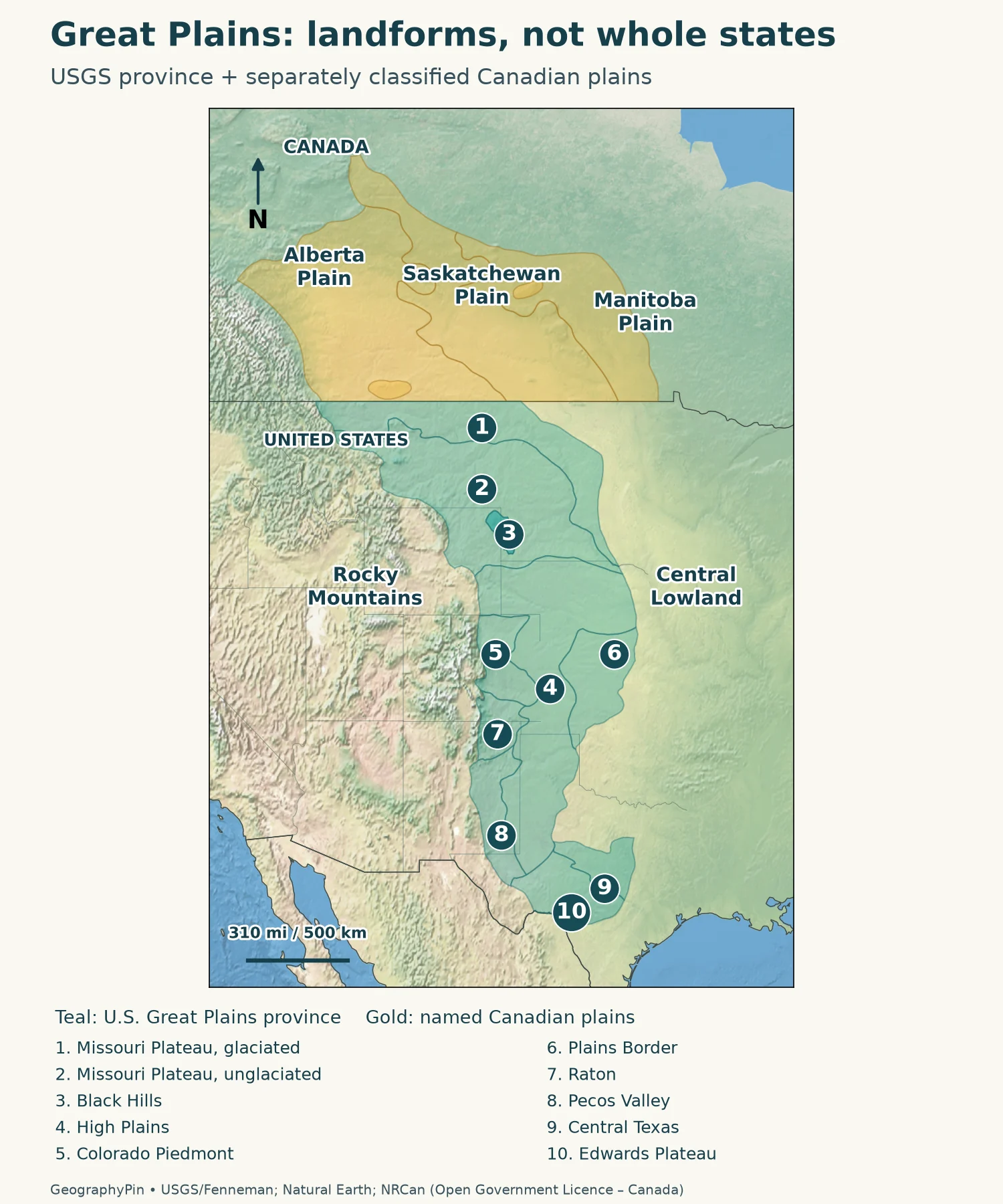
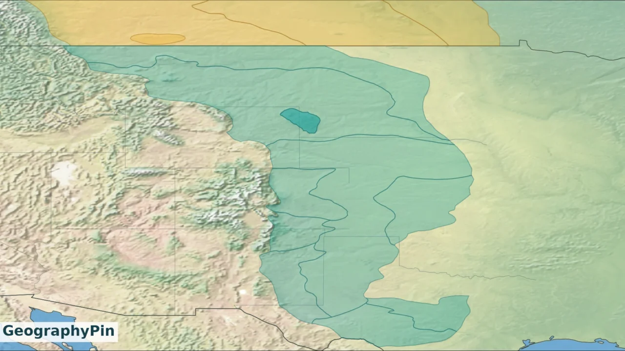
The Great Plains lie east of the Rocky Mountains and west of the Central Lowland, extending through the central United States toward the Canadian Prairies. This map uses the USGS physiographic province for the U.S. boundary. Canada’s adjoining plains are shown separately under its Interior Plains classification.
How to use this article: Start with the boundary convention, compare the Canadian continuation, or distinguish the High Plains from the larger region.
1. Great Plains Map and the Definition Behind It
Read the boundary convention
A physiographic region is an area grouped by its landforms and geological history. For the United States, the map follows the Great Plains province in the USGS digital version of the Fenneman–Johnson classification. Its regional-scale outlines are useful for orientation, not for deciding which side of a boundary an individual property occupies.

- Missouri Plateau, glaciated
- Missouri Plateau, unglaciated
- Black Hills
- High Plains
- Colorado Piedmont
- Plains Border
- Raton section
- Pecos Valley
- Central Texas Uplift
- Edwards Plateau
The mapped province is only one part of the broader Interior Plains. The Central Lowland lies to its east. Both belong to the continent’s interior, but they are not interchangeable names. The physical map of the USA places the Great Plains alongside the other major mountain and lowland systems.
Relief shading helps reveal texture: rugged mountain belts, smoother uplands and dissected valleys. It does not show today’s vegetation, rainfall or land use. A crop field, a grassland and an urban area can occupy the same physiographic unit.
2. Where the Region Begins and Ends
Mountains to the west, a less simple eastern edge
The western reference is the Rocky Mountain front. Much of the eastern edge is less visually dramatic: higher plains give way to lower terrain, sometimes across an escarpment, sometimes through a broader transition. A meridian is a convenient locator, but neither the 100th nor the 98th meridian is a universal landform boundary.
In the southern plains, the Caprock Escarpment marks the eastern edge of the High Plains. That is a boundary of a subdivision, so it should not be substituted mechanically for every edge of the entire Great Plains province. Farther south, the Edwards Plateau reaches the Balcones Escarpment beside the Coastal Plain. Different parts of the regional outline therefore follow different physical transitions.
The Canadian continuation uses another classification
North of the international border, the land does not suddenly stop being plains. Natural Resources Canada classifies the adjoining terrain within the Interior Plains. The Alberta Plain, Saskatchewan Plain and Manitoba Plain help explain the southern Canadian continuation, with steps between surfaces rather than one uniform level.
The Canadian Interior Plains also extend far north beyond the prairie grasslands. Conversely, the three Prairie provinces contain mountains, forest and Canadian Shield terrain as well as plains. Neither all of Alberta, Saskatchewan and Manitoba nor the whole Canadian Interior Plains should be colored as if it were the identical U.S. Great Plains province.
3. Which States Contain Part of the Great Plains?
Ten U.S. states contain portions of the mapped province. This is a list of intersecting states, not ten whole states forming an official political region. Use the regional outline inside each state rather than assuming the border follows a state line.
| State group | How to read the coverage |
|---|---|
| Montana and Wyoming | Plains occupy eastern areas; western mountain systems are not included simply because they share the state. |
| North Dakota and South Dakota | The Missouri Plateau and, in South Dakota, the Black Hills belong to the mapped province; the eastern lowlands require separate classification. |
| Nebraska and Kansas | Large plains areas lie in the west and interior; a whole-state fill would erase the transition toward the Central Lowland. |
| Colorado and New Mexico | Eastern plains are distinct from the Rocky Mountains and other western physiographic provinces. |
| Oklahoma and Texas | The province includes western plains and, in Texas, southern subdivisions such as the Edwards Plateau and Central Texas Uplift, rather than the entire states. |
The same caution applies to towns near a mapped edge. A regional polygon generalized from a small-scale source is a teaching reference, not a substitute for a detailed state geological map. It also does not assign cultural identities: residents may use “Plains,” “Midwest” or “West” in ways that differ from a geologist’s classification.
4. The Main Physiographic Subdivisions
The U.S. scheme separates the province into ten sections. Names such as “plateau,” “hills” and “valley” are a useful warning against imagining a perfectly flat grassland. The two Missouri Plateau entries reflect the contrasting effects of continental glaciation.
| Section | What distinguishes it |
|---|---|
| 1. Missouri Plateau, glaciated | Northern terrain modified by continental ice and glacial deposits. |
| 2. Missouri Plateau, unglaciated | Dissected plains, badlands and isolated uplands outside that glaciated subdivision. |
| 3. Black Hills | An uplifted, forested mountain mass within the surrounding plains. |
| 4. High Plains | A broad upland surface, including the southern Llano Estacado. |
| 5. Colorado Piedmont | Terrain eroded by the South Platte, Arkansas and their tributaries beside the mountain front. |
| 6. Plains Border | A transition of valleys and divides along the eastern side of the High Plains. |
| 7. Raton section | A distinctive area containing volcanic landforms in northeastern New Mexico and southeastern Colorado. |
| 8. Pecos Valley | The broad valley west of the southern High Plains. |
| 9. Central Texas Uplift | A distinct uplift exposing older rocks within the southern province. |
| 10. Edwards Plateau | A limestone plateau with extensive stream-cut terrain in Texas. |
These are regional classification names, not a complete inventory of individual landforms. The Nebraska Sand Hills, for example, are a recognizable dune landscape, but they are not an eleventh section in this table. The selected names on the map should be read together with the table rather than treated as a separate classification.
5. Why the Plains Are Not Uniformly Flat
Read the west-to-east terrain profile
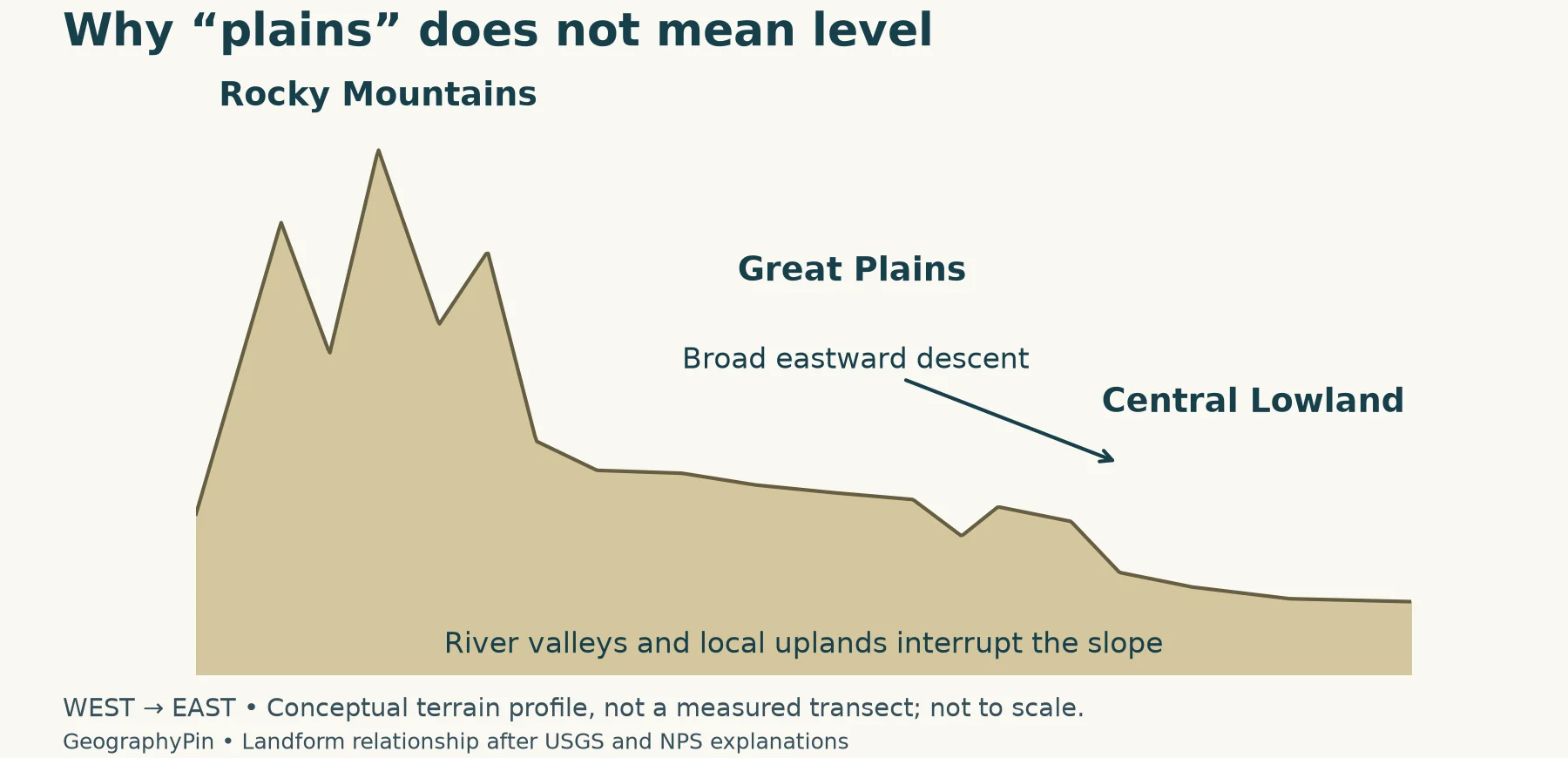
A plain describes broad surface form, not necessarily low elevation. Across much of the region the land stands higher toward the Rocky Mountains and descends eastward. River valleys interrupt that broad trend, and local uplands can rise above neighboring surfaces. A west-to-east profile makes the distinction easier to see than a state map.

The landscape is the product of more than one process. Sediment carried from the developing Rocky Mountains spread across parts of the plains; later rivers cut into those deposits and underlying rocks. Wind shaped dune areas and redistributed fine sediment. Continental ice modified the northern plains, while uplift and volcanism produced distinctive local terrain.
Three examples make the variety clear. The Black Hills rise above nearby plains. Badlands expose deeply eroded sedimentary terrain rather than an even surface. The Sand Hills of Nebraska contain dunes, many stabilized by vegetation. None is a reason to remove the surrounding region from the Great Plains; each explains why the broad regional name should not be mistaken for a description of every hillside.
Nor is a landform outline a storm-risk map. Weather crosses physiographic boundaries. The separate Hail Alley map uses reported hail observations and a stated analysis period, not membership in the Great Plains, to describe its pattern.
6. Great Plains, High Plains, Prairie and Midwest
High Plains: a part, not a synonym
In the classification used here, the High Plains are one section of the larger Great Plains province. The wider province also contains the Missouri Plateau, Black Hills and several southern units. A map labeled “High Plains” should therefore not quietly become the outline for all the Great Plains.
| Term | What it describes |
|---|---|
| Great Plains | A broad physical region; this map declares the U.S. physiographic convention. |
| High Plains | A subdivision of that province in the scheme used here. |
| Prairie | A grassland landscape or vegetation term, not the same landform boundary. |
| Midwest | A regional name; the Census version is a grouping of whole states. |
Prairie vegetation can extend beyond the Great Plains, and land inside the province need not be prairie. An ecological map can therefore be correct while drawing a different outline from this physiographic map. The legend needs to say what is being classified.
The Census Midwest includes the Dakotas, Nebraska and Kansas, but it also includes states farther east; Colorado, Montana and Wyoming belong to its West, while Oklahoma and Texas belong to its South. The U.S. Census regions map answers that statistical question. It does not replace a map of terrain.
Frequently Asked Questions
Can I use this map to draw a county-level Great Plains boundary?
Not reliably. The U.S. source was compiled for regional and national display at a scale of 1:7,000,000. County or property decisions require a more detailed source and an explicit local definition.
Why might a school atlas show a different eastern boundary?
It may use a simplified physical region, a grassland region or a climatic definition. Compare the legend and source before deciding that one line is wrong. This page uses the named physiographic province rather than a rainfall threshold.
Does the High Plains aquifer have the same outline as the High Plains section?
Do not assume so. An aquifer boundary describes the extent of a groundwater system, while a physiographic boundary classifies landforms. Use the USGS aquifer map for groundwater questions, not the outline shown here.
What Did We Learn Today?
The useful question is not simply which states are Plains states, but which definition a map uses. The Great Plains province crosses state lines and includes uplands, valleys and hills; the High Plains are only one of its sections. Canadian plains continue the physical landscape under a different classification, while prairie vegetation and Census regions describe other patterns.
Sources & Data Notes
The U.S. regional convention is the Fenneman–Johnson physiographic classification distributed by USGS, originally mapped at 1:7,000,000. Canadian terminology follows Natural Resources Canada. These landform classifications are not vegetation zones, weather-risk boundaries or groupings of complete states. The original GeographyPin maps overlay USGS section polygons and three NRCan division polygons on Natural Earth II shaded relief. The colors show separately defined regions, not elevation bands. The terrain profile is conceptual, not a measurement. These generalized maps are not suitable for local boundary decisions. Contains information licensed under the Open Government Licence – Canada; adapted by GeographyPin, with no government endorsement. Natural Earth data are public domain.
- USGS: Physiographic divisions of the conterminous U.S.
- Donald E. Trimble, USGS Bulletin 1493: The Geologic Story of the Great Plains
- National Park Service: Great Plains Province
- Natural Resources Canada: Physiographic Regions of Canada
- Alberta Geological Survey: Quaternary Geology of the Western Plains
- U.S. Census Bureau: regional definitions