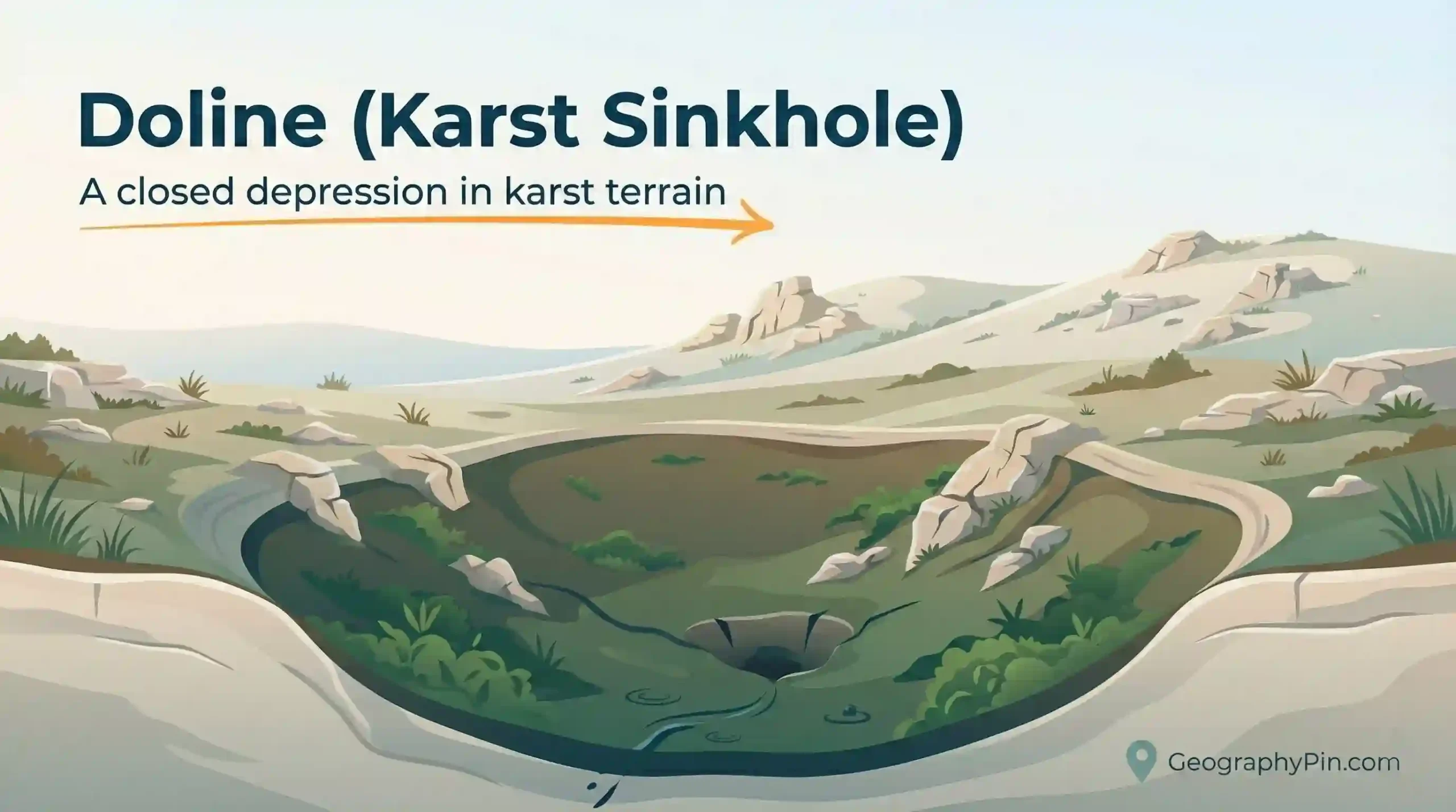
A doline (also seen as “dolina”) is one of the most recognizable features of karst terrain: a closed depression that pulls water inward and often sends it underground. In plain English, many people simply call it a sinkhole. The useful question is what kind of sinkhole it is and what it suggests about the rock and water pathways below.
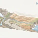
A doline is a natural, enclosed depression in a karst landscape, formed as soluble rock (often limestone) dissolves, settles, or collapses. Many sources use “sinkhole” for the same landform, especially in everyday English. Dolines concentrate runoff into the ground, sometimes through fractures, soil voids, or a single swallow point.
How to use this article: For quick identification, start with the fast check; for wording confusion, jump to doline vs sinkhole; for look-alikes, use the comparison table; for short answers, go to FAQ.
What is a doline?
A doline is the geomorphology term for a closed surface depression in karst. “Closed” matters: the land surface slopes inward, so water tends to collect and infiltrate rather than drain away through a normal surface stream network.
In the field, a doline can look like a gentle grassy bowl, a steeper rocky funnel, or a wooded hollow with a damp bottom. Some dolines drain quickly through openings in the ground; others pond seasonally if the drain is plugged by sediment or if the local water table rises close to the surface.
Doline, sinkhole, and “karst depression” are often overlapping words
“Sinkhole” is widely used as the general English term for a ground depression caused by removal of material underground. In many karst regions, “doline” is the more specific landform label used in mapping and scientific writing. You’ll also see “karst depression” as a wider category that can include dolines plus larger compound basins.
What a doline is not
A doline is not the same thing as a road pothole, a quarry pit, a bomb crater, or a construction settlement hollow. Those can resemble sinkholes, but the causes differ. A doline is also not a typical river valley: river valleys connect outward into drainage networks, while a doline is an inward-draining “collection point.”
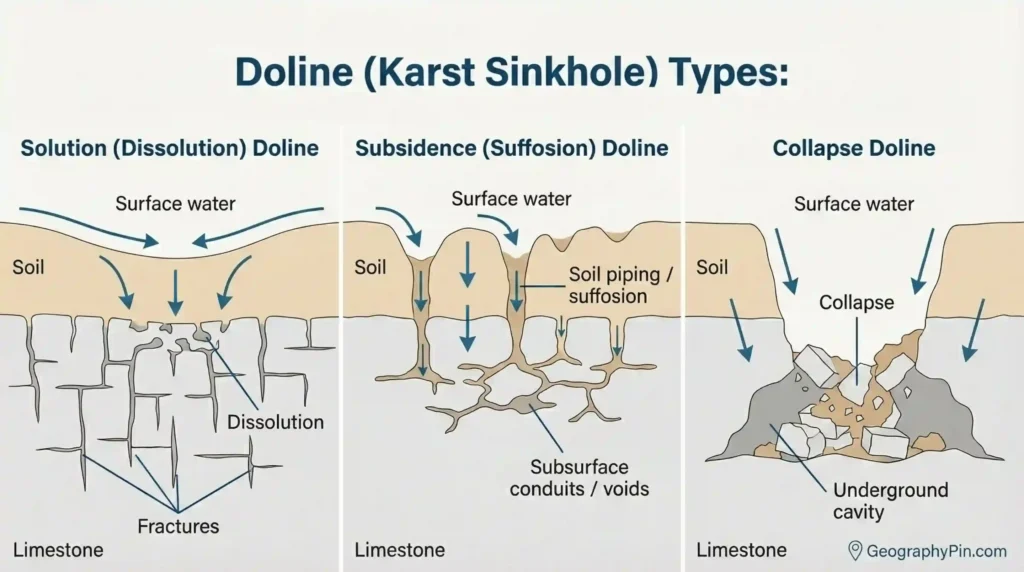
How do dolines form?
Dolines form where water creates or exploits void space underground. In karst, the core process is chemical dissolution: slightly acidic water enlarges fractures and bedding planes in soluble rock, gradually opening subsurface pathways. The surface can then sag into that hidden space—or, in some cases, fail suddenly.
Three common formation paths
- Solution (dissolution) doline: Rock dissolves from the surface and just below it, slowly lowering the ground into a bowl or funnel shape. These are often wider at the rim than they are deep, and soils can wash inward toward the center.
- Subsidence (suffosion) doline: Soil and sediment migrate downward into openings in the rock. The surface settles over time and may show subtle unevenness before a clear hollow appears.
- Collapse doline: A roof over a cavity (or a weakened zone) fails, producing a steeper-sided hole or a sudden deepening. This is the “sudden sinkhole” scenario people picture most easily.
Triggers that can speed up change
Even when a doline forms slowly, changes in water flow can accelerate settling or collapse. Intense rainfall, rapid infiltration from concentrated drainage (like a culvert outlet), leaking pipes, or shifts in groundwater conditions can all matter. The exact trigger varies by geology and site history, so it’s safer to treat rapid change as a sign of instability rather than assume one universal cause.
How to recognize a doline
You can often spot a doline by thinking like water: if rain falls here, does it flow away—or does it collect and go down? A doline is a place where the landscape encourages inward drainage. On the ground, that might be obvious (a clear hollow) or subtle (a shallow sag that still drains internally).
Fast check: five clues that point to a doline
- Closed shape: the rim is higher than the center in most directions, creating inward slopes.
- No normal outlet: there’s no surface stream leaving the depression as a defined channel.
- Water behavior: puddles linger in the center after rain, or water disappears at a single low point.
- Vegetation pattern: wetter plants or greener growth at the bottom; drier cover on the rim (not universal, but common).
- Karst context: nearby clues like springs, disappearing streams, caves, or exposed soluble bedrock strengthen the diagnosis.
Map and image clues (when you’re not on-site)
On contour maps, dolines often appear as closed contour loops with the lowest elevation in the middle. Some map styles add hachures (short tick marks) to indicate a depression, but not all cartography uses them consistently. On high-resolution hillshade or LiDAR, dolines can show up as clean circular or elliptical dimples—especially where fields or short vegetation make micro-topography easier to see.
Warning signs that deserve extra caution
Fresh ground cracks, a newly formed scarp, leaning fence posts, or a rapidly widening depression can indicate active subsidence or collapse. If the ground is changing quickly near buildings, roads, or buried utilities, treat it as a safety issue and seek local professional guidance.
Doline vs sinkhole and related karst depressions
Doline vs sinkhole: the practical difference
In everyday conversation, “sinkhole” is the broad word people reach for—sometimes even for non-karst problems like washed-out fill, broken storm drains, mine collapse, or failing utility trenches. “Doline” is more tightly tied to karst: a closed depression shaped by dissolution, subsidence, or collapse in soluble rock.
A useful rule for clear writing is: if you mean the karst landform, say “doline (karst sinkhole)” once near the top and then use “doline” afterward. That keeps the terminology accurate without losing readers who searched for “sinkhole.”
Not all sinkholes are karst sinkholes
Sinkhole-shaped depressions can form outside classic karst. One well-known example is collapse into lava-tube caves in basalt, where a void roof fails and creates a hole at the surface. The landform looks similar, but the geology and groundwater behavior can be very different from limestone karst.
Comparison table: dolines and common karst look-alikes
| Feature | What it usually means | Easy clue in the landscape |
|---|---|---|
| Doline | A closed karst depression formed by dissolution, subsidence, or collapse. | Inward slopes with no surface outlet; water collects or drains underground. |
| Cenote | A sinkhole that opens to groundwater, commonly associated with limestone platforms. | Visible water at the base, often with steep rock walls. |
| Swallow hole / ponor | A point where surface water sinks into the subsurface (a drainage inlet). | A stream disappears into a hole, crack, or rubble zone. |
| Uvala | A larger compound depression; the term is used inconsistently across regions and references. | An irregular basin with multiple inward-draining sub-hollows. |
| Polje | A broad closed karst basin with a flatter floor and complex internal drainage. | A wide basin-like “field” in karst, sometimes with temporary water and sinking points. |
A naming rule that keeps articles accurate
If the landform is a closed depression in soluble-rock karst, “doline” is appropriate. If you need the most common public-facing phrase, “karst sinkhole” is usually the safest bridge. If the cause is clearly non-karst (mining, infrastructure failure, washed-out fill), avoid calling it a doline.
Why dolines matter in real life
Dolines are not just “holes.” They are locations where surface water and the subsurface can connect directly. That matters for safety, land use, and water quality—especially in karst regions where groundwater can move quickly through enlarged fractures and conduits, sometimes with limited natural filtration.
Hazards: when a doline becomes a problem
The main risk is ground instability. A long-lived doline can be stable, but active subsidence or collapse can threaten roads, foundations, and buried utilities. The visible surface depression may be only one expression of a larger void-and-fracture network.
Water and pollution: dolines as recharge funnels
Many dolines function as recharge funnels that deliver runoff into karst aquifers. That can be beneficial for water supply, but it can also increase vulnerability if pollutants enter the recharge zone. In many karst settings, what happens on the surface can show up in groundwater faster than people expect.
Practical, low-regret behavior around dolines
- Keep drainage gentle: avoid concentrating runoff into one point near a depression.
- Don’t use dolines as dumps: anything poured or buried may travel into groundwater.
- Watch for change: new cracks, sudden settling, or widening depressions deserve attention.
- Get site-specific advice: for building or repairs near active movement, local geotechnical or geological expertise matters.
FAQ
Is a doline the same as a sinkhole?
Often, yes in practical usage. “Sinkhole” is the broad everyday term, while “doline” is a more specific karst landform term. If the depression forms in soluble rock through dissolution, subsidence, or collapse, calling it a doline (karst sinkhole) is usually accurate.
Do dolines only form in limestone?
They are most strongly associated with limestone and dolomite karst, but similar enclosed depressions can form in other soluble rocks such as gypsum or salt. The key idea is that rock can be removed or weakened by water-driven processes.
What’s the difference between a doline and a cenote?
A cenote is a sinkhole that exposes groundwater—often with a water-filled bottom and steep rock walls. A doline is the broader category of closed karst depression; it may be dry, soil-filled, seasonally wet, or water-filled depending on local drainage and water table conditions.
Do all dolines connect to caves?
No. Some dolines sit above cave passages, but many are controlled by fractures and sediment-filled voids with no walkable cave connection. The subsurface pathway can be narrow cracks rather than a large open cavern.
Are dolines always dangerous?
Not always. Many dolines are stable landforms that have existed for a long time. Concern rises when there are signs of active change—fresh cracking, rapid settling, or sudden deepening—especially near infrastructure.
How are dolines mapped?
They are mapped using field surveys, aerial imagery, and topographic data. High-resolution elevation models are especially useful because they reveal subtle closed depressions that can be hard to recognize from ground level alone.
What Did We Learn Today?
- A doline is a closed depression in karst that concentrates water inward and often drains underground.
- Many readers will recognize the same landform as a karst sinkhole, especially in everyday English.
- Dolines can form by dissolution, subsidence, or collapse, and the surface shape reflects that pathway.
- Identification is mostly about inward drainage plus context: other karst clues often sit nearby.
- Not every “sinkhole” is karst; similar-looking holes can form by other processes, including roof collapse over volcanic lava tubes.
Sources & Data Notes
Doline and karst-sinkhole definitions are typically drawn from geological surveys, groundwater/karst education materials, and university hydrogeology/geomorphology references. Terminology varies by region (especially terms like “uvala”), so the article focuses on field-safe concepts like closed drainage, formation pathways, and common look-alikes. I avoided precise size ranges and event statistics because they are highly site-specific; where you need local planning or hazard context, the most reliable sources are regional geological surveys and karst management guidance for your area.