A Europe map has two separate problems: fitting the small countries into a readable picture and explaining which countries its list includes. This atlas addresses both with four regional sheets and a declared 44-country reference. Use the numbered maps and keys to find each country.
This Europe map uses the 44-country reference derived from UN M49 Europe: 43 UN member states plus the Holy See, represented by Vatican City. Four regional sheets provide readable country locators. Russia is classified as one whole country, although its Asian territory extends beyond the European map frame. Other European counting conventions differ.
How to use this resource: Check the counting rule, read the boundary notes, or print a practice map.
1. Start With the Regional Overview
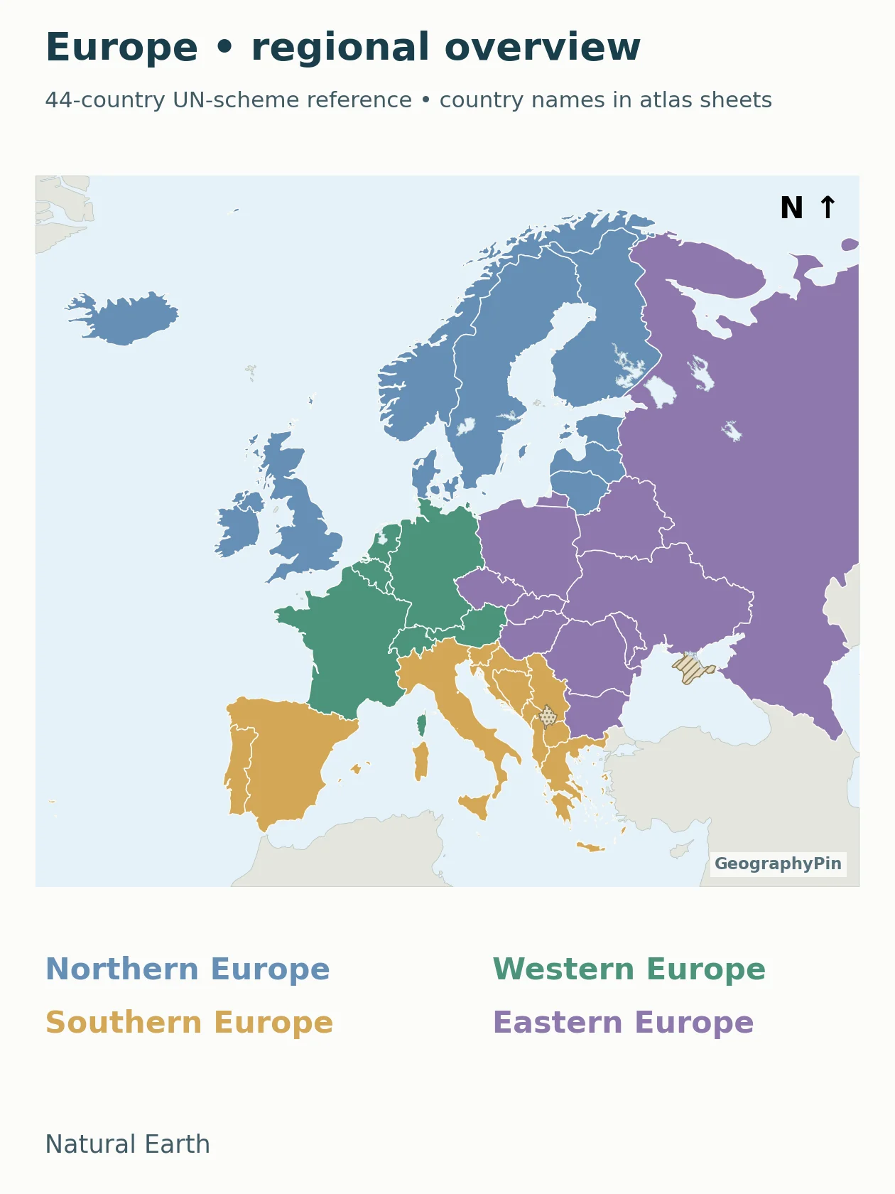
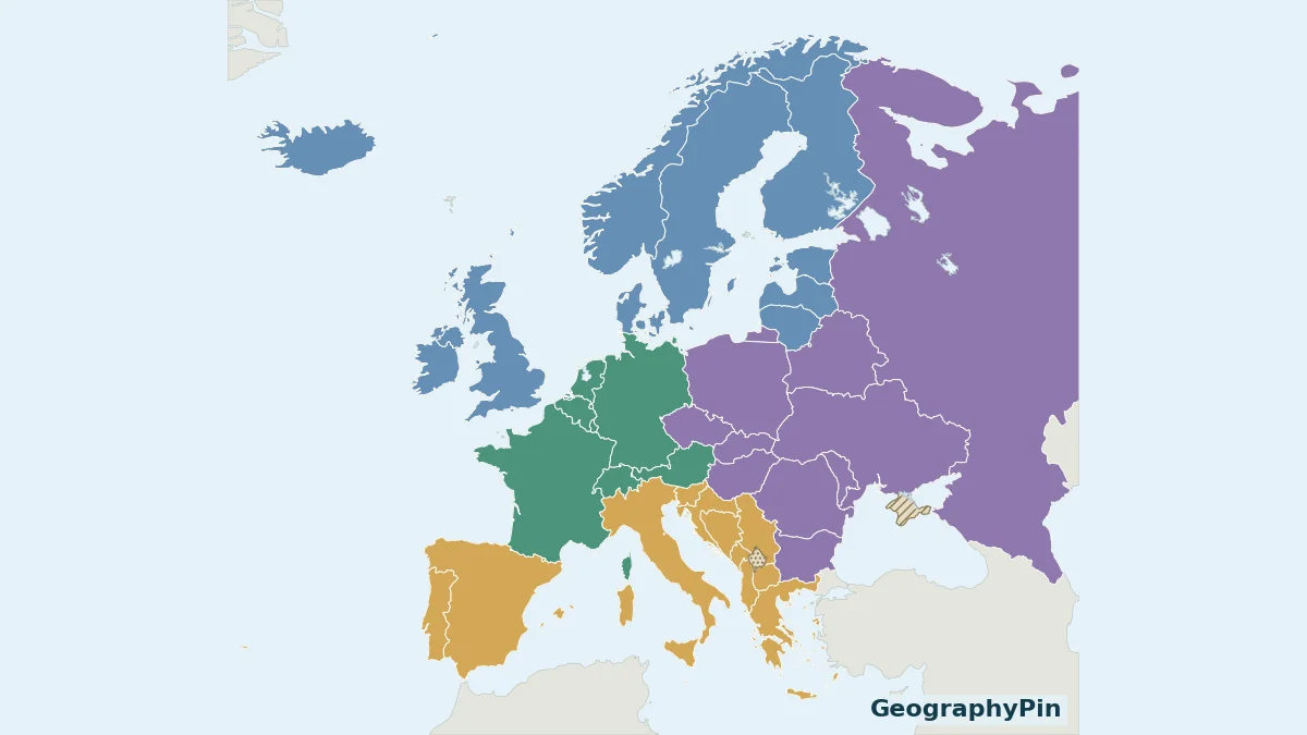
The overview colors tell you which regional sheet to open. They do not indicate population, elevation, wealth, language or alliance membership. Country names are deliberately moved to the larger regional sheets rather than made too small to read.
For capitals and the explicit broader 50-country convention, use the established Europe countries and capitals reference. Its different total is explained by a different scope, not by a missing country hidden in the map key.
2. Open the Readable Country Sheets
Open the regional sheet you need. Each sheet has its own numbered country key directly under the map; numbering restarts on each sheet. The numbers locate countries, not capitals, and are not rankings.
Northern Europe: 10 country locators
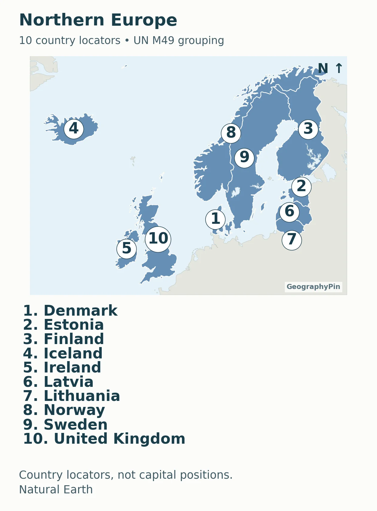
Download this regional sheet as PDF.
Accessible map key: 1. Denmark; 2. Estonia; 3. Finland; 4. Iceland; 5. Ireland; 6. Latvia; 7. Lithuania; 8. Norway; 9. Sweden; 10. United Kingdom.
Western Europe: 9 country locators
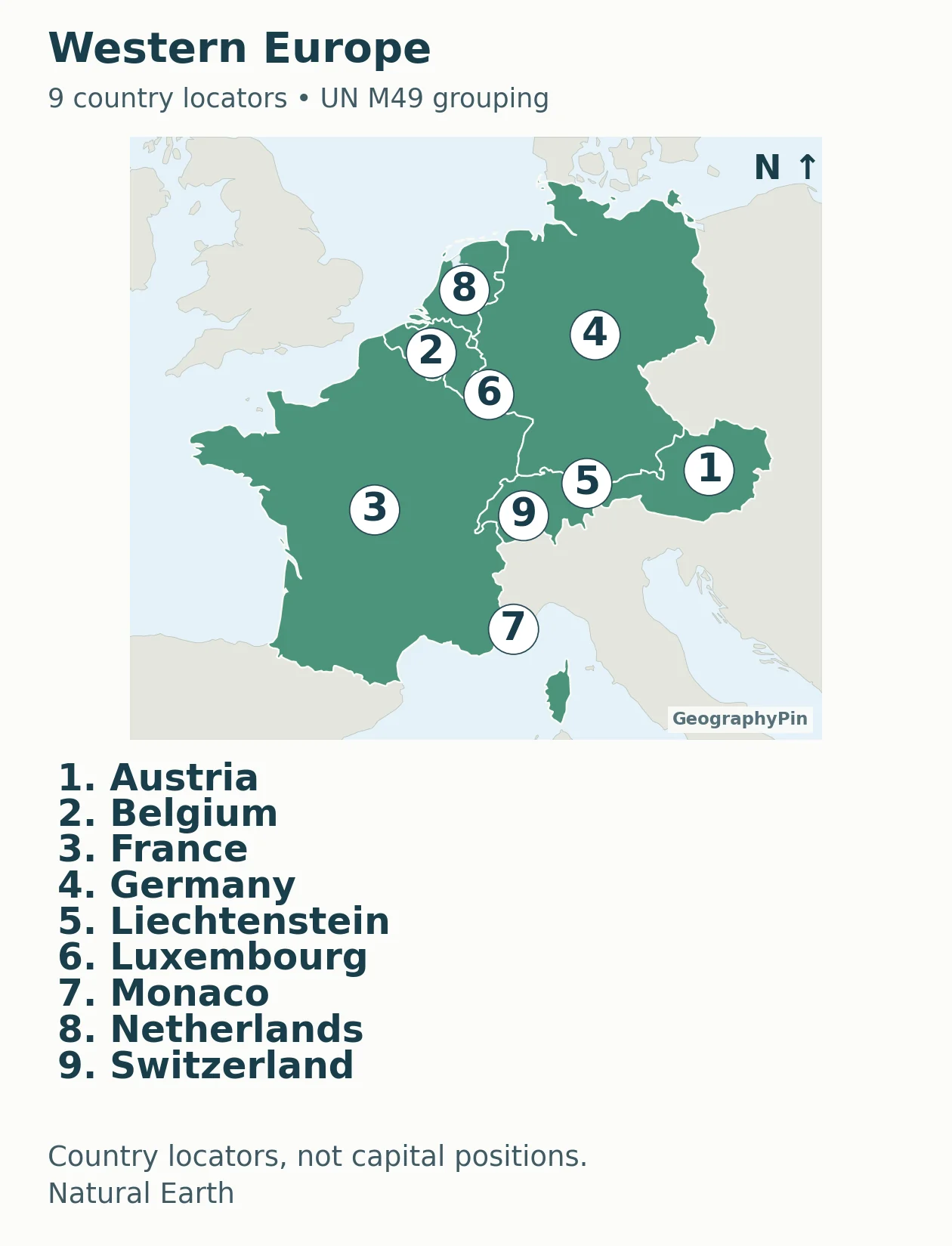
Download this regional sheet as PDF.
Accessible map key: 1. Austria; 2. Belgium; 3. France; 4. Germany; 5. Liechtenstein; 6. Luxembourg; 7. Monaco; 8. Netherlands; 9. Switzerland.
Southern Europe: 15 country locators
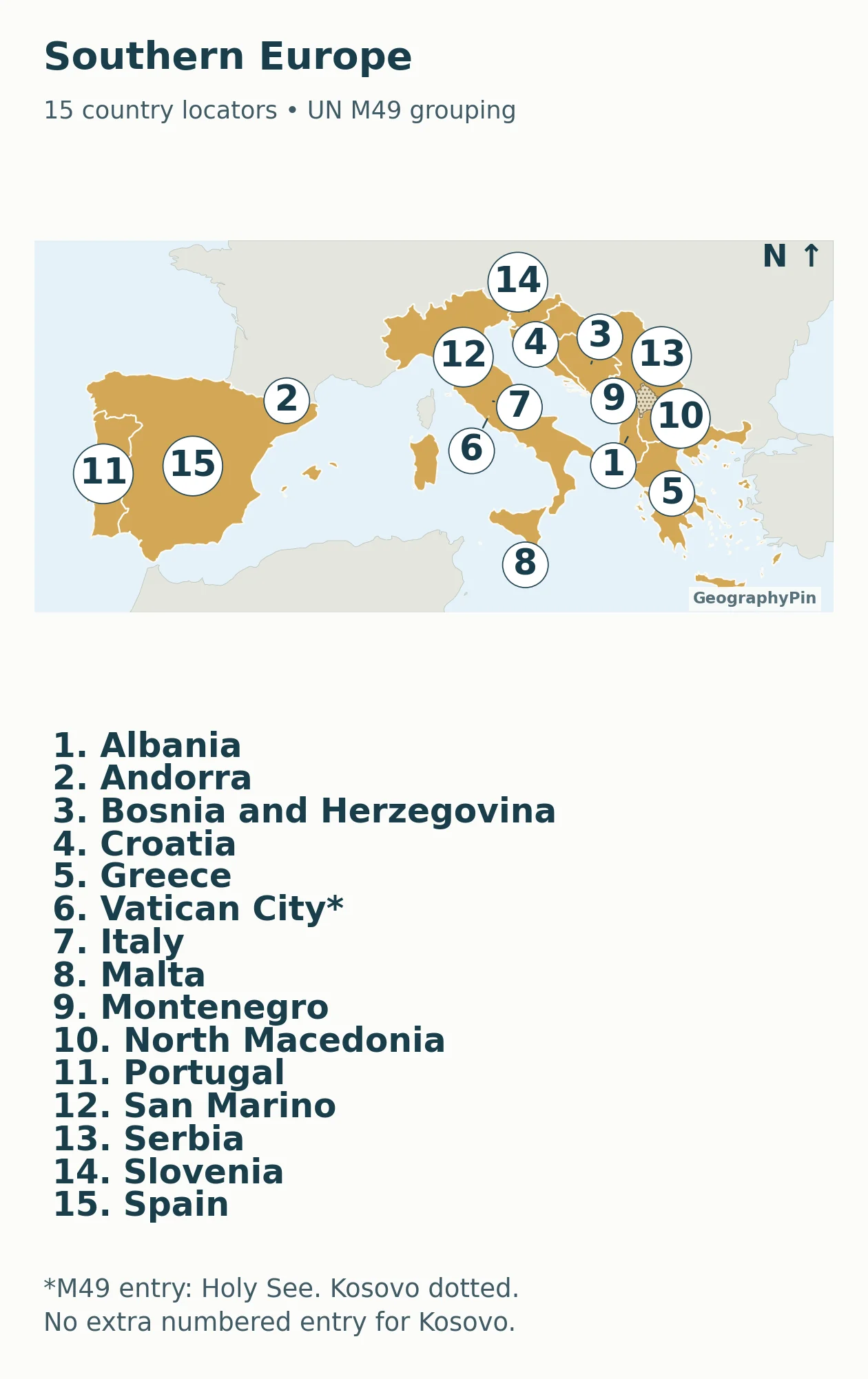
Download this regional sheet as PDF.
Accessible map key: 1. Albania; 2. Andorra; 3. Bosnia and Herzegovina; 4. Croatia; 5. Greece; 6. Vatican City / Holy See; 7. Italy; 8. Malta; 9. Montenegro; 10. North Macedonia; 11. Portugal; 12. San Marino; 13. Serbia; 14. Slovenia; 15. Spain.
Eastern Europe: 10 country locators
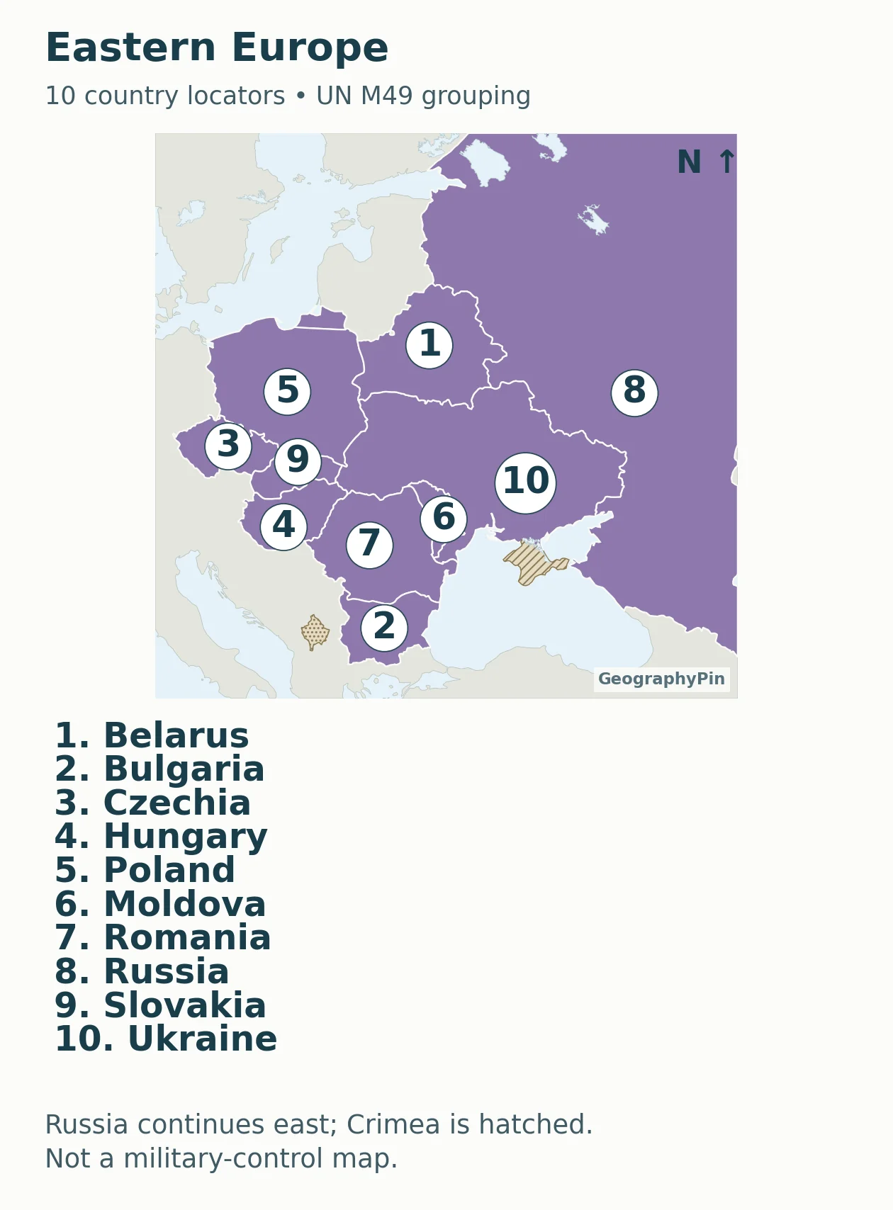
Download this regional sheet as PDF.
Accessible map key: 1. Belarus; 2. Bulgaria; 3. Czechia; 4. Hungary; 5. Poland; 6. Moldova; 7. Romania; 8. Russia; 9. Slovakia; 10. Ukraine.
A local number can refer to different countries on different sheets. Always keep the sheet name with the number when using the maps as an exercise. The accompanying downloadable key preserves that pairing, together with the country name, ISO code and M49 reference.
3. Understand the Counting and Boundary Rules
The 44-country reference is a convention
The count includes the sovereign-country entries in M49 Europe while excluding separately listed dependencies and areas. Its four groups contain ten countries in Eastern Europe, ten in Northern Europe, fifteen in Southern Europe and nine in Western Europe. The Holy See entry is represented cartographically by Vatican City and is counted once.
This is narrower than GeographyPin’s broader 50-country Europe list. M49 assigns Armenia, Azerbaijan, Cyprus, Georgia and Türkiye to Western Asia, and Kazakhstan to Central Asia. Those six are not extra numbered members of this atlas. Their omission identifies the classification being used; it does not settle cultural or physical definitions of Europe.
A country grouping is not the continent’s physical outline
M49 places Russia in Eastern Europe as one country, without dividing its statistics between Europe and Asia. The regional sheet shows only the western portion because a full Eurasian view would make the smaller European countries too small to identify. The frame is a viewing window, not a new border across Russia.
The same distinction matters for territories outside the European map frame. This resource is a regional country locator, not a claim to show every overseas component of every selected state. It does not color Greenland as an extra European country or count dependent territories as additional states.
Kosovo and Crimea are explicitly annotated
Under M49, Kosovo is considered within Serbia for that statistical classification. This atlas therefore has no separate numbered Kosovo entry; its area is dotted so it is not silently concealed inside an unqualified outline. Kosovo’s recognition remains disputed, and a map using a different counting convention may show it separately.
Crimea is hatched within Ukraine’s internationally recognized territorial scope. Its source-defined polygon was removed from Natural Earth’s default Russia geometry and joined to Ukraine. UN General Assembly resolution 68/262 affirms Ukraine’s territorial integrity and rejects a change of Crimea’s status based on the 2014 referendum. Neither annotation represents current military-control lines.
4. Print the Blank Map and Practice
Labeled atlas, blank map and map-key file
Download the complete labeled regional atlas (PDF) · Download the blank continent map (PDF) · Download the country key (PDF).
For a first exercise, use the blank overview to identify the broad regional position of a country. Then open its labeled sheet to check the answer. For very small countries or islands, use a leader line or numbered dot rather than trying to write the entire name inside a tiny outline. Explain that the symbol marks location and is not drawn to the country’s physical size.
The country locators are not capital-city coordinates. For capitals, use the linked country-and-capital reference. Placing a capital at a country-number marker would turn a useful map key into false geographic information.
Print with “fit to page” if needed. The vector PDF remains clear when enlarged, but enlarging it does not add geographic detail beyond the generalized source. These maps are for regional learning, not border surveying or long-distance measurement. The numbered sheets use a north-up regional display; a single uniform distance scale is not asserted for the whole atlas.
What Did We Learn Today?
The atlas separates a statistical country list from a cropped regional view. Its four sheets keep the 44-country reference readable, including small-state locators, while explaining Russia’s extent and the Kosovo and Crimea annotations. Choose the classification first; then use the same map and blank practice sheet consistently.
Sources & Data Notes
Country grouping follows the stated UN M49 convention. The map-key downloadable key records the selected entries, not a new sovereign-recognition list. Natural Earth version 5.1.1 provides generalized country and disputed-area geometry under public-domain terms. Explicit source-based geometry adjustments are documented in the accompanying methodology note. No live control, population or distance-measurement dataset is implied.