Lisbon is often pictured as a city of hills beside a vast expanse of water. Both impressions are useful, but neither tells the whole story. The water beside the central city is the Tagus estuary, while the wider metropolitan region crosses municipal boundaries and reaches well beyond the historic waterfront.
Lisbon is Portugal’s capital, on the western Iberian Peninsula beside the northern bank of the Tagus, or Tejo, estuary. Its central waterfront faces estuarine water connected to the Atlantic Ocean. Hills and valleys shape the city, while the Lisbon Metropolitan Area extends beyond Lisbon municipality to both sides of the estuary.
Start here: Distinguish riverfront from ocean coast, explore hills and valleys, or compare the different meanings of Lisbon.
1. Where is Lisbon?
A riverfront city with an Atlantic connection
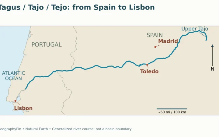
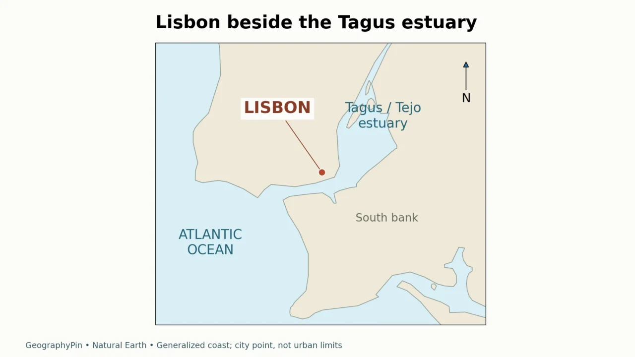
Lisbon is on the western side of the Iberian Peninsula, in mainland Portugal. Its familiar central waterfront faces the Tagus estuary. The Atlantic lies beyond the estuary’s outlet to the west and southwest. Calling Lisbon an Atlantic port is therefore compatible with describing its central shoreline as a river or estuary waterfront.
Tagus is the conventional English name; Tejo is Portuguese. A sign referring to the Tejo is not directing you to a different river. Near Lisbon, the river opens into a broad tidal water body rather than remaining a narrow channel with two closely spaced banks.
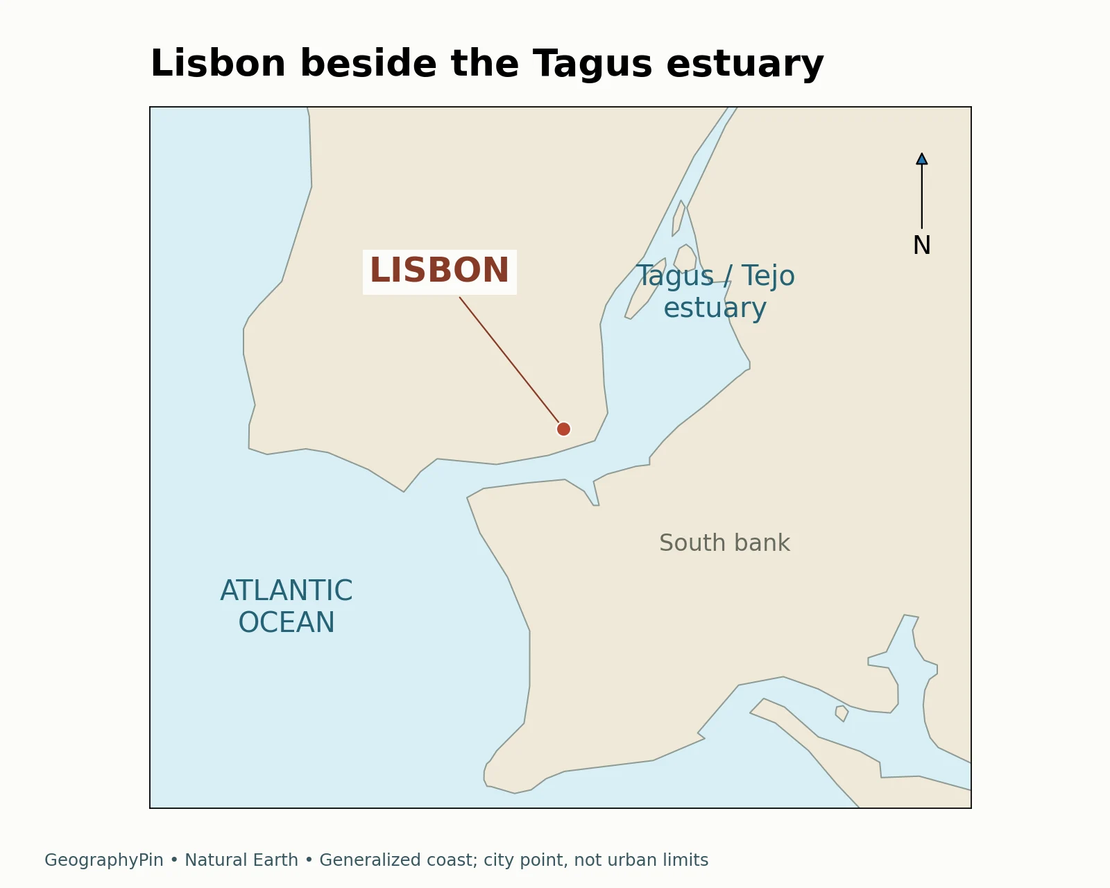
Read the map in three steps: locate the ocean, follow the opening inland, then find Lisbon on the northern side of the lower estuary. The larger water area farther inland is part of the estuarine setting, not a separate inland lake. For the wider vocabulary, see river channels, tributaries and drainage basins.
2. Hills and valleys shape the city
Why a flat map misses part of Lisbon
Lisbon’s municipal planning report describes an uneven landscape organized by hills and valleys. It identifies valleys including Alcântara, Chelas and Valverde, the latter associated with Avenida da Liberdade, and hills around Castelo, Graça and Senhora do Monte. The riverfront is only one part of that relief.
This matters when interpreting distance. Two places close together on a street map may be separated by a steep climb. A shoreline walk, a route up to a hilltop and a journey along a valley do not involve the same terrain even when their map distances look similar.
“City of seven hills” is a familiar cultural description, not a complete terrain model of the modern municipality. For actual orientation, named ridges, slopes, valleys and street connections are more useful than trying to fit every neighborhood into a fixed hill count. A city-wide elevation also cannot describe both low waterfront space and higher ground.
The map above is a locator, not a relief map. It shows where Lisbon sits beside the estuary; a detailed terrain or pedestrian map is needed to compare slopes and walking routes.
3. Lisbon, its municipality and the metropolitan area
Which area does the name describe?
A city name can describe a place people recognize, an administrative territory or a wider region linked by everyday movement. Lisbon is no exception. The Área Metropolitana de Lisboa, or AML, is a public territorial association of 18 municipalities. Lisbon is one member; it is not another name for all 18.
| Term | Useful meaning | Do not assume |
|---|---|---|
| Lisbon as an urban place | The city and its recognizable neighborhoods | That every informal description follows an administrative boundary |
| Lisbon municipality | A local-government territory | That its statistics include the entire metropolitan region |
| Lisbon Metropolitan Area / AML | The association of 18 municipalities | That all member municipalities lie on Lisbon’s side of the estuary |
| Tagus estuary | A physical water and shoreline system | That it shares the city or metro boundary |
AML includes places such as Cascais and Sintra on the northern side of the wider region and Almada, Seixal and Barreiro to the south of the Tagus. A regional trip can therefore leave Lisbon municipality while remaining within the metropolitan area.
The distinction is especially important for population. A municipality count, a built-up-area estimate and a metropolitan total answer different questions. Compare the same territory and reference year, and distinguish census results from later estimates. Our guide to geographical areas explains why administrative, physical and functional boundaries need not coincide.
4. What the waterfront tells you
Belém is a river-mouth gateway, not the entire city
The relationship between Lisbon and the estuary is visible at Belém. UNESCO’s World Heritage property comprises the Monastery of the Hieronymites and the Tower of Belém, associated with the shore of the Tagus and the entrance to Lisbon’s port. The tower’s location makes more sense when read as part of a maritime approach than as an isolated monument on a generic beach.
UNESCO also notes changes around the tower from land reclamation and river silting. That is a reminder that a historic waterfront image and a modern shoreline map need not match exactly. Neither a postcard nor a generalized coast layer establishes the position of an earlier riverbank.
The city’s municipal history describes the estuary as a sheltered maritime approach that helped shape transport, trade and urban development. Quays, docks and warehouses belonged to that relationship. Today, public spaces along the water and connections with south-bank municipalities continue to make the estuary part of everyday metropolitan geography.
Belém, the central waterfront and the wider metropolitan shore should not be collapsed into one landmark. A photograph of the tower identifies a specific setting; it does not show the whole city, every port facility or the entire UNESCO property.
5. Lisbon’s climate: a pronounced dry summer
What the 1991–2020 station normals show
Lisbon’s Atlantic setting does not mean rainfall is evenly spread through the year. IPMA’s climate normals for Lisboa / Instituto Geofísico, station 535, show a marked summer dry season and wetter autumn and winter months. These are averages for 1991–2020 at a named station, not a forecast or a uniform value for every neighborhood.
The average daily temperature was about 53.2°F (11.8°C) in January and 74.8°F (23.8°C) in August. These are monthly means of daily average temperature, not average afternoon highs. The distinction matters: describing August as “75 degrees” without naming the measure would hide the warmer daytime conditions.
| Month | Average monthly precipitation |
|---|---|
| January | 4.09 inches (103.8 mm) |
| July | 0.10 inch (2.6 mm) |
| August | 0.21 inch (5.4 mm) |
| November | 5.27 inches (133.9 mm) |
The contrast is substantial: July and August are much drier than November in this record. A dry monthly average does not mean rain is impossible, just as a wet-season average does not mean rain falls every day. For understanding the city’s physical setting, seasonality is more informative than a single annual rainfall total.
IPMA identifies this as a hybrid series combining observations and modeled data. The station record provides a consistent climate reference, but it should not be read as an identical temperature or rainfall amount for the entire metropolitan area.
Frequently Asked Questions
Is Lisbon on the ocean or a river?
The central waterfront is on the Tagus estuary, which connects to the Atlantic. Lisbon is an Atlantic port, but its familiar city-center waterfront is not simply an open-ocean beach.
Are Tagus and Tejo different rivers?
No. Tagus is the conventional English name and Tejo is the Portuguese name for the same river.
Is Lisbon Metropolitan Area the same as Lisbon city?
No. AML comprises 18 municipalities, including Lisbon. Its territory extends across both sides of the Tagus and includes other municipalities such as Almada, Cascais and Sintra.
Is Lisbon flat?
No. Hills, slopes and valleys are important parts of the city’s geography. A flat street map can hide substantial changes in elevation.
Does the Belém World Heritage site cover all Lisbon?
No. The property consists of the Monastery of the Hieronymites and Tower of Belém. It is not a designation for the whole modern city.
What Did We Learn Today?
Lisbon combines a hilly urban setting with an estuary waterfront and an Atlantic connection. The city, municipality, metropolitan area and Tagus estuary are different geographic objects. Reading the water, relief and boundaries separately prevents a harbor view, a population figure or a regional destination from being mistaken for the whole city.
Sources & Data Notes
Original GeographyPin maps use Natural Earth 1:10 million land geometry and a populated-place point. They show generalized coastlines, not municipal boundaries, water depth or navigation routes. AML is used here for the association of 18 municipalities; population comparisons require a matching boundary and reference year. Climate figures are IPMA’s 1991–2020 normals for Lisboa / Instituto Geofísico (station 535), version 1.0 (2024), a hybrid observed-and-modeled series; unit conversions are rounded.
- Lisbon municipality: Lisbon and the Tagus
- Lisbon municipal planning characterization: relief and valleys
- AML: its role and member municipalities
- AML: municipality geography
- UNESCO: Monastery of the Hieronymites and Tower of Belém
- Natural Earth: public-domain data
- IPMA: Lisboa / Instituto Geofísico climate normals, 1991–2020