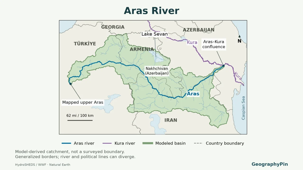
A blue line on a Caucasus map can be a river, an international boundary, or both. The Aras is especially easy to misread because it passes Azerbaijan’s separate Nakhchivan territory before reaching the main part of Azerbaijan, and does not remain a border river all the way to its mouth.
The Aras, also called Araks or Araxes, rises in eastern Turkey, follows several international border sections involving Armenia, Azerbaijan and Iran, then enters Azerbaijan to join the Kura near Sabirabad. Its drainage basin spans four countries. The combined river continues as the Kura to the Caspian Sea.
How to use this article: Trace the border sequence, distinguish two similarly named tributaries, or compare basin measurements.
1. Read the Aras River Map
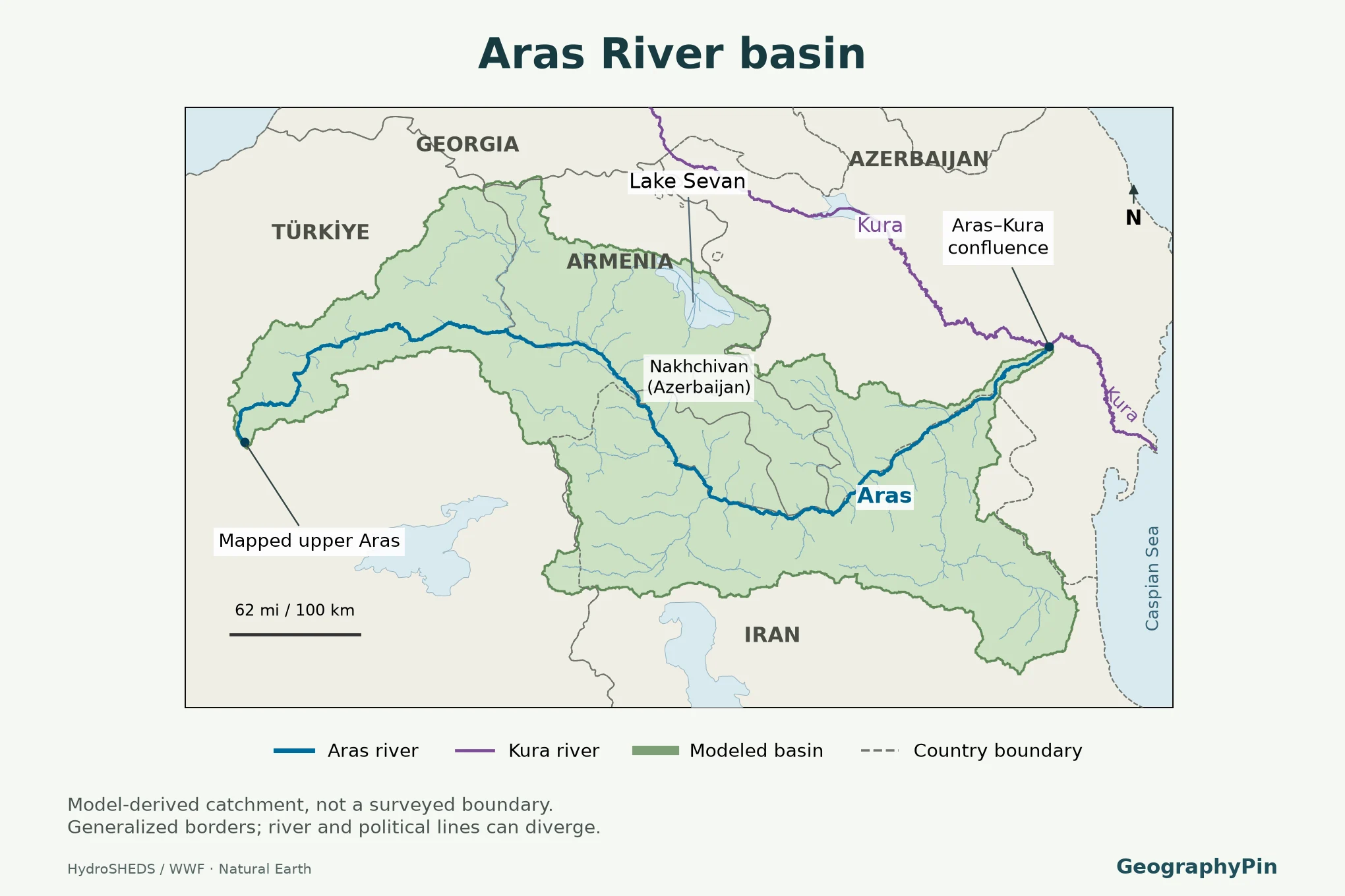
The headwaters lie in the Bingöl Dağ mountain region of eastern Turkey. From there, follow the river generally eastward toward the Armenian Highlands and the South Caucasus, then through the lowlands of Azerbaijan. Its bends matter: a river that trends east overall can run south or north along individual reaches.

Read the shaded basin as the land whose modeled surface drainage reaches the Aras before that confluence. Do not read it as the valley floor, an irrigated area, or territory administered by a single country. Some tributaries begin far from the main channel, so the catchment extends well beyond the riverbank.
Aras, Araks, Araz and Araxes
These names refer to the same main river. Aras is common in English-language maps; Araks appears frequently in Armenian and international water assessments; Araz is used in Azerbaijani sources; Araxes is a long-established historical and reference-work form. A label change at a frontier does not mark a new river.
The same multilingual pattern occurs downstream: Mtkvari and Kura name one river. But Aras and Kura are not alternative names for each other. They are separate rivers upstream of their meeting point.
2. Follow the River and Its Border Sections
The downstream border sequence
Follow the route from the Turkish headwaters toward the Kura, not by scanning the countries alphabetically. The table separates Nakhchivan from the main part of Azerbaijan for location only: both belong to the Republic of Azerbaijan. A short border section is still important even when it is hard to distinguish on a small regional map.
| Order and reach | Political geography | What to notice |
|---|---|---|
| 1. Upper course | Within Turkey | Mountain headwaters and upper valley precede the international river-border reaches. |
| 2. Turkey–Armenia | River forms part of the state boundary | The Ararat Plain lies beside this part of the river system. |
| 3. Turkey–Nakhchivan | Short Turkey–Azerbaijan boundary section | Nakhchivan is an Azerbaijani exclave, not a separate country. |
| 4. Nakhchivan–Iran | Azerbaijan–Iran boundary | This is the western Azerbaijani part of the border river. |
| 5. Armenia–Iran | Border along southern Armenia | The Meghri area separates the two Azerbaijani border stretches. |
| 6. Main Azerbaijan–Iran | Azerbaijan–Iran boundary again | The river continues beside the main part of Azerbaijan. |
| 7. Lower Aras | Within Azerbaijan | The river leaves the international boundary and reaches the Kura near Sabirabad. |
This sequence prevents two common mistakes. Iran does not face Azerbaijan continuously along the entire middle river: Armenia intervenes. Nor does the Aras form the whole Azerbaijan–Iran boundary. Farther east, the international boundary and river channel separate, while the river continues toward its confluence.
Country outlines here describe the broad international geography, not current border-crossing access, military positions or the precise legal ownership of islands and banks. A cartographic line at this scale cannot settle a boundary question. Likewise, seeing a road or bridge beside the river does not establish that a traveler may use it.
3. Tributaries: Which Rivers Feed the Aras?
The Aras receives tributaries from both sides. A left-bank tributary joins from the left when looking downstream, not necessarily from the left side of the printed map. Many mountain tributaries run toward the Aras from the Armenian Highlands and Lesser Caucasus; others approach from the Iranian side.
| River or system | Reading the name correctly |
|---|---|
| Akhuryan / Arpaçay | One tributary shared by Armenia and Turkey; do not confuse it with the Arpa farther east. |
| Arpa | A separate tributary shared by Armenia and Azerbaijan. |
| Hrazdan | The river draining Lake Sevan through the Yerevan area toward the Aras. |
| Vorotan / Bargushad | A transboundary tributary system listed under both names in UNECE assessments. |
| Voghji / Ohchu | Another transboundary system; spelling varies between national and international sources. |
| Kotur / Qotur and Sarisu / Sari Su | Names of additional transboundary tributaries in UNECE’s basin assessment. |
Why Akhuryan–Arpaçay is not the Arpa
Similar spellings can turn a correct-looking map into a wrong one. UNECE treats Akhuryan/Arpaçay and Arpa as separate sub-basins: the first is shared by Armenia and Turkey, the second by Armenia and Azerbaijan. Do not merge their routes because an older map abbreviates one name to “Arpa.”
For a wider view of the uplands supplying these rivers, see Armenia’s mountains, rivers and Lake Sevan. Lake Sevan’s water reaches the Aras through the Hrazdan; the Aras itself does not pass through the lake. A lake, its outlet river and the larger receiving river are three different features.
This is a selected-name guide, not a complete tributary inventory. A river’s length, drainage area and water contribution are different measures, and seasonal flow or withdrawals can change their relationship. The table is not a discharge ranking.
4. Where the Aras Meets the Kura
The Aras joins the Kura near Sabirabad in Azerbaijan. This is a confluence, where two rivers meet, rather than the Aras flowing directly into the Caspian Sea. Following the combined water downstream takes you along the Kura to the Caspian coast.
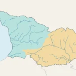
The distinction changes how a basin map should be interpreted. The Aras catchment is nested inside the larger Kura–Aras drainage system. An outline for the entire Kura system includes land draining to the Kura without first reaching the Aras, including areas in Georgia. Those areas must not be shaded as though they all feed the Aras.
A simple way to check a map is to start at Sabirabad and trace the two branches upstream. The Aras branch leads back toward the southern borderlands and eastern Turkey. The Kura branch leads farther into Azerbaijan and onward through Georgia. Tracing downstream instead takes you toward the Caspian. The three directions should not be confused.
The surrounding geography of Azerbaijan explains the transition from upland tributaries to the broad Kura–Aras lowland. “Kura–Aras lowland” names a physical region; “Kura–Aras basin” names a drainage system. They are not interchangeable outlines, and neither is another name for the Aras channel.
5. Basin Size, Reservoirs and Changing Channels
Why published basin areas differ
UNECE’s 2011 assessment gives the Aras a length of about 666 miles (1,072 kilometers). Its country-area table totals approximately 40,458 square miles (104,785 square kilometers). Other references, including Azerbaijan’s embassy geography information, give approximately 39,382 square miles (102,000 square kilometers) for the basin. These are reported reference figures, not measurements derived from the map above.
Keep the source and definition with the number. The 2011 table combines country submissions and earlier hydrographic information; a digital elevation-based catchment is a different product. Choosing an outlet, resolving flat terrain and representing artificial drainage can all affect a modeled outline. A disagreement does not by itself establish which particular method caused the difference. The modeled outline shown here covers approximately 37,103 square miles (96,097 square kilometers), smaller than either reported reference figure. It is a HydroBASINS-derived catchment, not a replacement survey of the published basin area.
Reservoirs are not a fixed water-volume statistic
The river system is regulated rather than an untouched channel. UNECE identifies the Aras storage dam and other storage and diversion works. Farther downstream, Azerbaijan’s presidency documented the Khudafarin commissioning and Giz Galasi inauguration on May 19, 2024, describing the Iran–Azerbaijan projects as serving irrigation and electricity generation.
A reservoir’s design capacity, the water actually stored on a particular date, and the amount released downstream are not the same quantity. An inauguration-day storage figure is not a permanent reservoir size. Stored volumes need an observation date, and a commissioning ceremony does not by itself establish subsequent generating output.
Riverbanks can also move. A 2021 study of a roughly 99-mile (160-kilometer) border reach examined changes from 1984 to 2019. That local study is evidence that parts of the channel are dynamic, not proof that every section changed equally. On a map, a slight difference between a generalized boundary and a river line may also reflect different datasets and scales; it cannot be interpreted automatically as a territorial change.
Frequently Asked Questions
Is the Aras the river that flows through central Yerevan?
No. The Hrazdan flows through Yerevan and joins the Aras farther downstream. Identifying the city’s river correctly helps distinguish a tributary from the basin’s main channel.
Does the Aras begin on Mount Ararat?
No. The headwaters are in eastern Turkey’s Bingöl Dağ region. The river later passes near the Ararat region; proximity farther downstream does not identify the source.
Is Aras UNESCO Global Geopark the whole river basin?
No. The geopark is an area in northwestern Iran beside part of the river. Its designation does not cover the entire four-country drainage basin.
What Did We Learn Today?
The Aras is one river with several names, a four-country catchment and a changing relationship to international borders. Nakhchivan and mainland Azerbaijan appear in separate stretches of its route; the lower river lies inside Azerbaijan before joining the Kura. Reading the channel, drainage basin, country boundary and reservoir as separate features makes the map more useful than treating every blue line or shaded area as the same thing.
Sources & Data Notes
This regional reference uses rounded U.S. customary conversions. UNECE’s 2011 country-area total and the separately reported 102,000-square-kilometer figure are retained with their sources, rather than averaged. Older FAO and Iranica material supports enduring physical geography only, not present political terminology, water quality or border access. The 2024 infrastructure event is dated; no live reservoir storage or electricity output is claimed. Generalized maps do not establish legal river boundaries or current conditions on the ground.
- UNECE — Second Assessment of Transboundary Rivers, Lakes and Groundwaters (2011), pp. 151–156
- Full UNECE assessment hosted by project partner Zoï Environment Network
- Embassy of Azerbaijan — geography and inland waters
- FAO Water Report 15 — Armenia: river basins and water resources
- Encyclopaedia Iranica — Araxes River: geography and historical naming
- Presidency of Azerbaijan — Khudafarin and Giz Galasi ceremony, May 19, 2024
- Geomorphological evolution along international riverine borders (2021)
- Armenian embassy in Iran — Aras Geopark location, June 21, 2023
- HydroBASINS — modeled catchments
- Armenian irrigation project environmental assessment, World Bank archive — Hrazdan hydrology
- Natural Earth — basemap terms of use
This product GeographyPin Aras River Map incorporates data from the HydroSHEDS version1 database which is © World Wildlife Fund, Inc. (2006–2022) and has been used herein under license. WWF has not evaluated the data as altered and incorporated within GeographyPin Aras River Map, and therefore gives no warranty regarding its accuracy, completeness, currency or suitability for any particular purpose. Portions of the HydroSHEDS v1 database incorporate data which are the intellectual property rights of © USGS (2006–2008), NASA (2000–2005), ESRI (1992–1998), CIAT (2004–2006), UNEP-WCMC (1993), WWF (2004), Commonwealth of Australia (2007), and Her Royal Majesty and the British Crown and are used under license. The HydroSHEDS v1 database and more information are available at HydroSHEDS.
HydroRIVERS and HydroBASINS: Lehner and Grill (2013), Global river hydrography and network routing. Original GeographyPin cartography; Natural Earth basemap is public domain. The level-8 catchment outline generalizes the small final outlet area at the Kura junction.