The Orinoco River rises in southern Venezuela, curves along part of the Colombian border, and crosses Venezuela toward an Atlantic delta. Its tributaries connect the Llanos with the Guiana Shield. An unusual upper-river branch, the Casiquiare, carries water into the Rio Negro and therefore into the Amazon system.
How to use this article: Trace the course, understand tributary connections, and explore the Amazon connection.
1. Where is the Orinoco River?
The Orinoco is a major river of northern South America. Its course is closely associated with Venezuela, but its drainage network also reaches far into Colombia. That distinction matters: a river’s main channel, an international boundary, and the area supplying water to the river are three different things. Our guide to river parts and drainage basins explains the underlying terms.
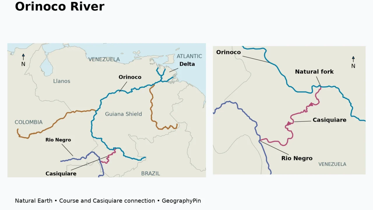
The headwaters lie at Cerro Delgado Chalbaud in the Parima Range of southern Venezuela, near Brazil. A 2018 study in Proceedings of the International Association of Hydrological Sciences gives the main channel a length of about 1,330 miles (2,140 kilometers). This is a rounded reference length, not a distance measured from the simplified line on this map.
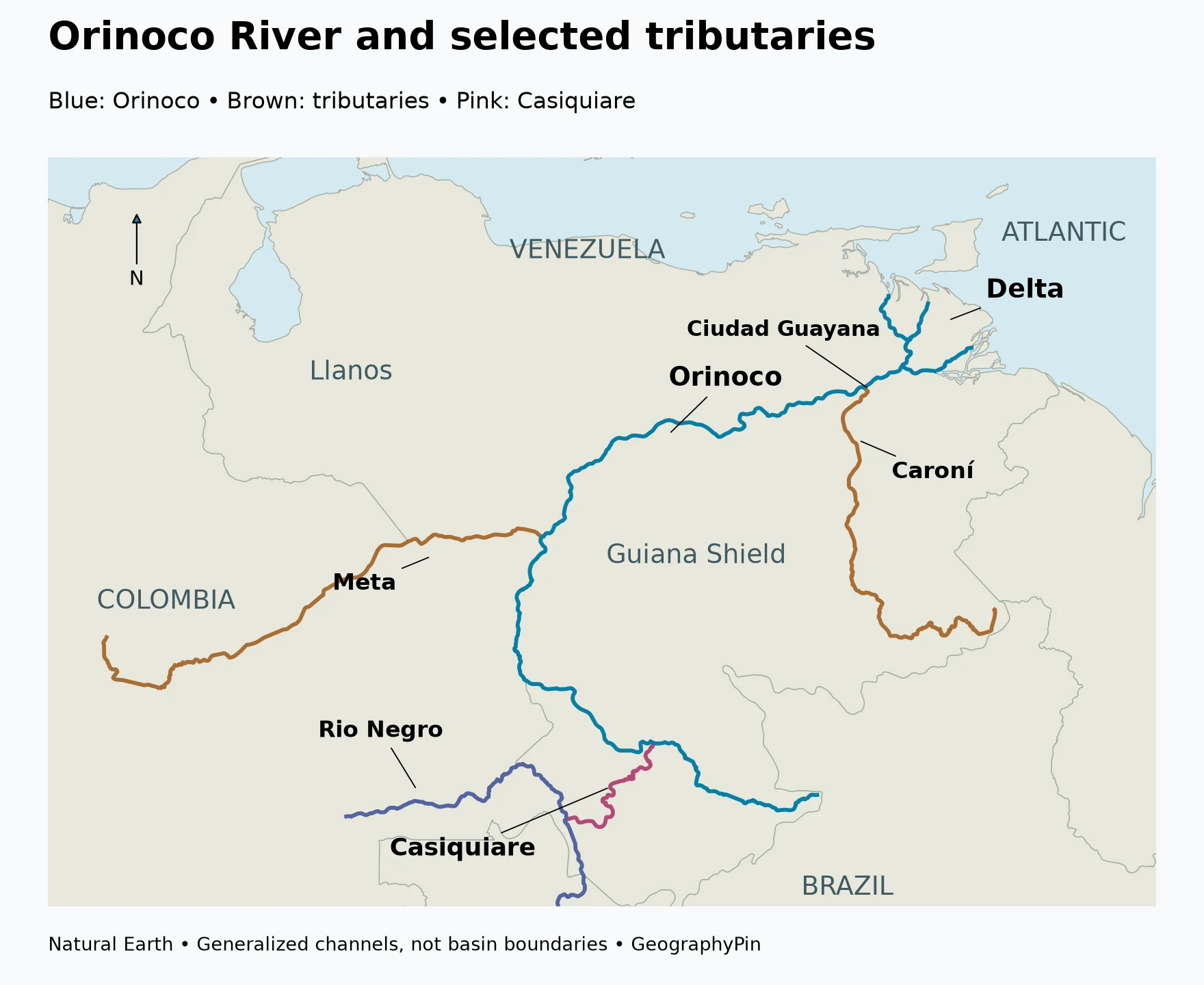
Follow the great arc toward the Atlantic
Rather than following a straight eastward route from its source to the sea, the river makes a broad arc. From the southern headwater region it runs generally westward, then turns north along the western side of the Guiana Shield. Farther downstream it swings east across Venezuela toward the Atlantic coast.
This curved course helps explain the arrangement of its tributaries. Rivers coming across the Llanos approach from the west and north, while tributaries draining the Guiana Shield approach from the south and southeast. Near the coast, the single named river becomes a branching delta network rather than one neat line ending at a single beach.
River countries and basin countries are not interchangeable
Part of the Orinoco forms the Venezuela–Colombia boundary; much of the mainstem lies within Venezuela. Colombia is also a major contributor through tributaries draining the eastern side of the Andes and the Llanos. Brazil’s proximity to the headwaters does not mean that the Orinoco mainstem flows across Brazil.
The Amazon connection is different again. Water diverted into the Casiquiare eventually reaches Brazil through the Rio Negro, but that route should not be described as the Orinoco main channel continuing through Brazil. The river has branched into another drainage system.
| Feature | Geographic relationship | Why it matters |
|---|---|---|
| Upper Orinoco | Southern Venezuela, near the Brazilian frontier | Headwater setting and Casiquiare branching region |
| Western arc | Includes a Colombia–Venezuela border reach | Explains why both countries belong in an Orinoco geography discussion |
| Llanos tributaries | Approach from western and northern parts of the basin | Connect distant plains and Andean drainage with the main river |
| Guiana Shield tributaries | Approach from southern uplands | Bring a contrasting landscape and water character into the system |
| Lower river and delta | Venezuela, opening toward the Atlantic | Transition from a large river corridor to tidal channels and wetlands |
2. How the Llanos and Guiana Shield shape the river
The Orinoco gathers water from landscapes that are strikingly different. To its west and north are extensive plains crossed by rivers coming from the Andes. To the south and southeast are older uplands, forested valleys and the table mountains associated with the Guiana Shield.
Tributaries crossing the Llanos
The Meta and Apure are important rivers in the western and northern tributary network. Their channels connect plains with the Orinoco, while their broader catchments include water and sediment arriving from higher ground. The Guaviare is another important Colombian tributary, although the overview map selects the Meta and Caroní rather than depicting every major tributary.
The Llanos are not simply a uniform grass-covered surface. Freshwater Ecoregions of the World describes a mosaic of seasonally flooded and non-flooded savannas, gallery forests along rivers, wetlands and floodplain lakes. As water levels change, the connections between river channels and surrounding lowlands also change.
This is why a dry-season photograph can look very different from a wet-season view of the same general region. Some areas become connected by floodwater, while other surfaces remain above it. A river centerline is useful for orientation, but the seasonal floodplain is a much wider and more variable environment.
The Caroní brings in a different landscape
The Caroní joins the Orinoco at Ciudad Guayana. Its drainage comes from the Guiana Shield, contrasting with the sediment-bearing rivers that cross the Llanos from the Andes. The shield includes old bedrock, uplands, forested valleys and steep local drops, rather than only a flat lowland plain.
A NASA astronaut-image account of Ciudad Guayana shows the contrast particularly clearly: the sediment-rich Orinoco appears brown, while the Caroní water is much less muddy. A visible mixing zone develops below their meeting point. The exact appearance depends on conditions, but the confluence illustrates how tributaries carry the signature of the landscapes they drain.
Water color should not be treated as a simple pollution test. Suspended mineral sediment, dissolved organic material, illumination and water depth can all affect what a river looks like. Here, the documented contrast is a geographic clue to different source landscapes, not a claim that one entire river is clean and another is contaminated.
3. The Casiquiare connection: one river branches into another system
The most unusual feature of Orinoco geography lies far upstream. The Casiquiare River branches away from the Orinoco and flows toward the Rio Negro, which is part of the Amazon drainage system. This is a natural connection, not a canal excavated to join two rivers.
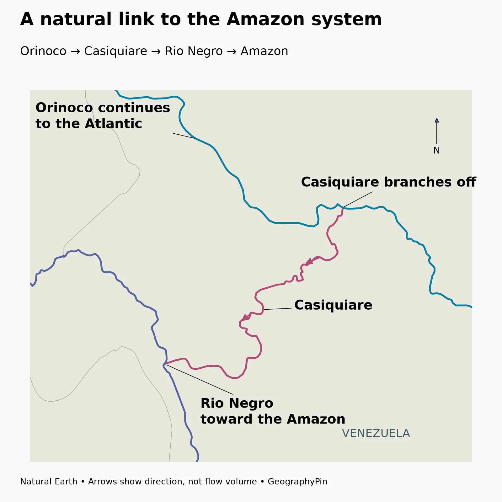
A distributary leaves; a tributary joins
A tributary brings water into a river. A distributary branches away from it. The Casiquiare is a distributary of the Orinoco, but it contributes water to the Amazon system through the Rio Negro. Both descriptions can therefore be correct, depending on which river system is being discussed.
The sequence is:
Orinoco → Casiquiare → Rio Negro → Amazon.
The rest of the Orinoco continues around its arc toward its own Atlantic delta. The connection does not mean that the whole Orinoco flows into the Amazon or that the two rivers share one final main channel.
Why the fork is easy to misread
On a map without arrows, the Casiquiare junction can look like an ordinary tributary joining the Orinoco. NASA’s 2025 explanation of the fork emphasizes that the apparent convergence is actually a divergence: water leaves the Orinoco through the smaller branch.
Most classroom drainage diagrams show tributaries steadily combining downstream inside clearly separated basins. The Casiquiare is a useful reminder that real drainage networks can be more complicated. A natural water connection can cross what would otherwise be drawn as a boundary between two major river systems.
The arrows in the detail map show the documented direction of the connection. Their width does not represent a measured flow rate or a fixed share of the Orinoco’s discharge. Seasonal hydrology matters, and the map is not a claim that the amount of diverted water stays constant throughout the year.
4. From the lower river to an Atlantic delta
Downstream, the Orinoco becomes a large river corridor with islands, bars and multiple channels around them. Ciudad Bolívar and Ciudad Guayana are important geographic reference points along this lower part of the system; Ciudad Guayana also marks the Caroní confluence.
A field study near Ciudad Bolívar examined how flow and sediment reshape a mid-channel island. Its observations show why a large river should not be imagined as a rigid trench: water can erode one part of a bank while depositing sand elsewhere. The study concerns a particular reach and survey period, not a uniform rate of change for the entire Orinoco.
The delta is a river and coastal environment
Near the Atlantic, branching channels, wetlands and coastal processes replace the simpler image of one river between two banks. UNESCO describes the Orinoco Delta Biosphere Reserve as an environment shaped by both river and marine processes, with mangroves, swamp forests, other forest habitats and shallow waters.
Tides influence the delta channels, so its geography cannot be explained by downstream river flow alone. Freshwater delivery, sediment movement and marine influence interact across the coastal landscape. The delta is also inhabited, including by Warao communities; it is not an empty backdrop at the end of a map.
The biosphere reserve is a designated area within this broader delta environment. Its administrative boundary should not be confused with the full extent of the Orinoco drainage basin, or with a single fixed line separating all freshwater from coastal water.
5. Read an Orinoco map without these common mix-ups
Do not place the source in the Andes. The river’s own headwaters are in the Parima Range. Andean tributaries supply water and sediment to the wider network, which is a different statement from saying that the Orinoco itself begins in the Andes.
Do not turn the Casiquiare into an engineered canal. Some labels call it a channel or “canal,” but the hydrologic link is natural. For this article, “Casiquiare River” avoids suggesting that people dug it.
Do not place the main outlet in the Caribbean. The Orinoco’s delta opens toward the Atlantic. Nearby coastal geography and the Gulf of Paria can complicate small-scale maps, but they do not change the river’s broad Atlantic destination.
Do not equate every Guiana Shield river with an Orinoco tributary. The shield extends beyond this basin. A landscape region and a drainage basin need not have the same outline; some neighboring rivers drain separately toward other outlets.
A good way to remember the system is to follow three connections: plains rivers feeding the Orinoco, shield rivers joining from the other side, and the Casiquiare branching toward the Amazon. Those relationships explain more than memorizing a length alone.
Frequently Asked Questions
Where does the Orinoco River start and end?
Its headwaters are at Cerro Delgado Chalbaud in the Parima Range of southern Venezuela. The main river ends in an Atlantic delta.
Does the Orinoco flow through Colombia?
Part of the main river forms the Colombia–Venezuela boundary, while much of the course is within Venezuela. Colombian tributaries also drain a large part of the wider basin.
Is the Orinoco connected to the Amazon?
Yes. The Casiquiare branches away from the Orinoco and joins the Rio Negro, which flows into the Amazon. The main Orinoco continues toward its own Atlantic delta.
Is the Casiquiare a man-made canal?
No. It is a natural river connection. The word canal sometimes used in its name should not be read as evidence of an excavated waterway.
Does Angel Falls fall directly into the Orinoco?
No. It lies in the Churún drainage within the wider Caroní tributary network. The Caroní eventually joins the Orinoco at Ciudad Guayana.
What Did We Learn Today?
The Orinoco curves from southern Venezuela toward an Atlantic delta, gathering water from the Llanos and Guiana Shield along the way. Its geography includes a border reach with Colombia, contrasting tributaries such as the Meta and Caroní, and the unusual Casiquiare branch that feeds the Amazon system through the Rio Negro. The main channel, drainage basin, natural connection and coastal delta each describe a different part of the same river story.
Sources & Data Notes
- Morphodynamic change analysis of bedforms in the Lower Orinoco River, Venezuela (2018): headwaters, 2,140-kilometer reference length, basin landscapes and local island sediment dynamics. Field observations are not presented as current basin-wide conditions.
- Freshwater Ecoregions of the World: Orinoco Llanos and Orinoco Guiana Shield: tributary landscapes, seasonal habitats and Churún/Caroní relationship.
- NASA Earth Observatory: When Rivers Take a Weird Turn (2025): Casiquiare branching direction and connection through the Rio Negro. No constant diverted-flow percentage is assumed.
- NASA Earth Observatory: Ciudad Guayana (2006): Caroní confluence and documented sediment-color contrast. Historical population and industrial figures are not used.
- UNESCO: Delta del Orinoco Biosphere Reserve: river–marine habitats and Warao communities. Reserve area is not equated with delta or basin area.
- Fundación Empresas Polar: Orinoco, río: broad course and named tributary context.
- Natural Earth public-domain data: original GeographyPin map geometry.
Cartographic method: Actual Natural Earth 1:10m country and selected river geometries are displayed with equal aspect in a Lambert azimuthal equal-area projection centered at 6°N, 67°W. The maps do not depict basin outlines, flood extent, political claims or a complete delta network. The dataset label “Casiquiare canal” is displayed as Casiquiare to avoid implying artificial construction. The Amazon-connected Rio Negro is selected geographically rather than by its name alone. Arrows follow ordered Casiquiare geometry from the Orinoco junction toward the Rio Negro. No missing channels have been drawn by guesswork.
Length: The cited 2,140-kilometer figure converts to approximately 1,330 miles. Published river lengths can differ with source and channel conventions; it is not calculated from the display geometry.