A river terrace is a step-like remnant of an older river valley floor, left above the active channel after the river cuts to a lower level. Its surface may preserve river-deposited sediment or a bench eroded into bedrock. Terraces help reconstruct landscape history, but their height alone does not reveal their age or cause.
How to use this article: Start with the valley cross-section, compare fill and strath terraces, or examine what terrace ages mean.
1. What a river terrace looks like
Find the tread and the riser
A river valley can contain more than today’s channel and floodplain. Look higher along its sides and you may notice relatively flat benches separated by steeper slopes. Some are river terraces, also called fluvial or stream terraces: remnants of surfaces associated with earlier stages of the river.
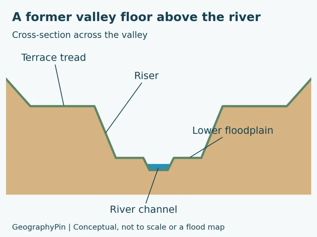
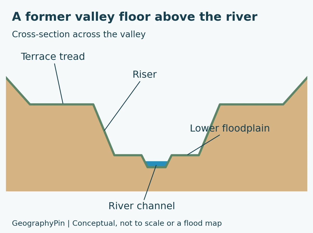
The flatter bench is the tread. The slope separating it from a lower surface is the riser. These terms describe the shape, not a particular rock type or age, as outlined in Rose and colleagues’ review of terrace formation. The National Park Service explains that stream terraces may consist of river deposits or surfaces cut into bedrock.
Terrace versus active floodplain
The active floodplain belongs to the river’s present system of channel movement and overbank flooding. A terrace records a former level that the river has largely abandoned as it cut down. For the broader channel-and-basin context, start with what a river is. Both can look flat, so “flat land beside water” is not enough to tell them apart.
In a simple cross-section, the terrace stands above the lower floodplain, separated by a slope. Real valleys may have incomplete benches, tributaries cutting through them, or younger sediment covering parts of the old surface. Do not expect every valley to match a symmetrical staircase.
A bench also needs geological context before it can confidently be called a river terrace. A road cutting, agricultural terrace or other human-made step is not automatically evidence of an ancient river. The important question is whether the surface and its underlying materials record earlier river activity.
2. How river terraces form
A former surface is left behind
The basic sequence has two parts. First, the river occupies or develops a valley-floor surface through erosion, deposition or both. Later, it cuts to a lower level, leaving remnants of the earlier surface above its new channel. This downward cutting is called incision.
If the river repeats the process and enough remnants survive, the valley can develop several terrace levels. That is a sequence of preserved surfaces, not a promise that every past stage remains visible. Later erosion can remove parts of the record.
The British Geological Survey’s account of the Thames Valley describes ancient floodplain deposits isolated as the river cut downward. It also explains how the river shifted sideways during its longer history. Terraces therefore record changes in a river’s position as well as its elevation.
More than one process can trigger incision
A terrace is not, by itself, proof that the land rose in an earthquake. River behavior depends on several connected controls: the amount of water, the sediment supplied to the channel, the material being eroded and conditions downstream.
Changes in land elevation or downstream base level can influence a river. Base level is the lower level toward which a river can erode; the sea is an important control for rivers that reach it, but local controls also matter. Climate can change runoff and sediment supply, altering the balance between deposition and erosion.
Research by Merritts, Vincent and Wohl on northern California rivers found different influences along the same river systems: sea-level changes were particularly important downstream, while uplift strongly influenced reaches farther inland. That is a specific regional example, not a universal formula for every terrace.
Incision is not necessarily steady
In a study of British rivers, Macklin, Lewin and Jones linked episodes of Holocene entrenchment to extreme floods and changing catchment conditions rather than interpreting them simply as a direct response to uplift. Their findings illustrate why the same landform can have different explanations in different settings.
The practical lesson is to distinguish the observation from the interpretation. “There is an abandoned surface above the river” is an observation. “It formed because the land rose” is an explanation that requires additional evidence.
3. Fill terraces and strath terraces
Fill terraces preserve accumulated sediment
A river can build up sediment in a valley, a process called aggradation. If it later cuts into that accumulated material, remnants can remain above the lower channel. These are commonly described as fill terraces.
The key is the sediment body beneath the surface. A fill terrace is not defined solely by its height or by the fact that the top is flat. The UC Davis Center for Watershed Sciences teaching example from the Chilcotin River explains how sediment accumulation and subsequent incision can produce terraces.
Strath terraces preserve an eroded rock bench
A strath is a bedrock surface eroded by a river. When the river cuts below that surface, a surviving bench can form a strath terrace, often with a relatively thin cover of river sediment.
The visible top may therefore be gravel even though the defining feature beneath it is an eroded rock surface. Simply spotting gravel on a terrace does not prove that it is a thick fill terrace. Exposures, geological mapping or subsurface information help distinguish the two.
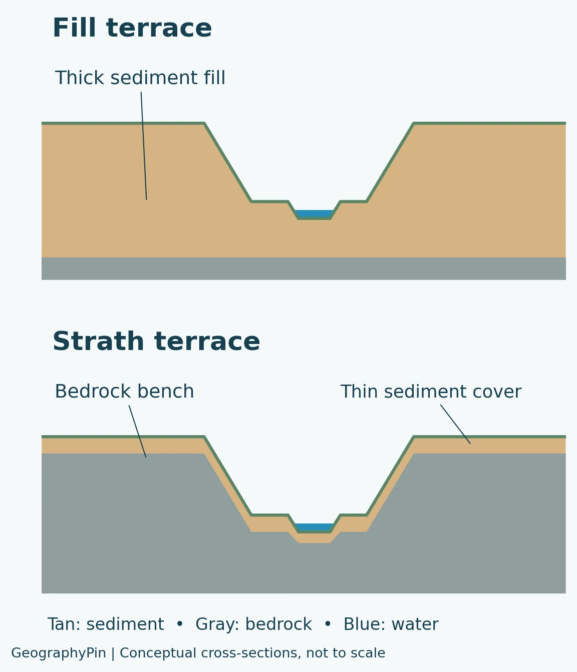
| Feature | Fill terrace | Strath terrace |
|---|---|---|
| Main material beneath the tread | A body of previously accumulated river sediment | An eroded bedrock bench, often with an alluvial cover |
| Important part of its history | Deposition followed by cutting into the fill | River erosion of bedrock followed by abandonment at a higher level |
| What the outline alone tells you | Not enough to establish sediment thickness | Not enough to locate the buried rock surface |
| Useful evidence | Sediment layers and the geometry of the valley fill | The bedrock surface and its relationship to the sediment cover |
These are useful basic categories, not an exhaustive classification. Geological studies may distinguish additional types, including terraces cut within older fills. Always check how a particular map or research paper defines its terms. A spreading deposit at a valley mouth is a different relationship: see alluvial fans for that landform.
4. What terraces tell us about the past
Higher is often older, but context comes first
Within a correctly correlated sequence formed as a river progressively incised, a higher abandoned level generally predates a lower one. That useful pattern should not be turned into a universal dating rule.
Comparing terrace heights in unrelated valleys does not establish which is older. Even within a valley, identifying equivalent surfaces requires evidence. Later erosion, changes in the river’s course and deformation can complicate the record. A height measurement is not a numerical age.
Matching benches are not the whole story
Terraces preserved at corresponding levels on opposite sides of a valley are described as paired. Some remnants are unpaired, with no matching bench preserved on the other side. A missing counterpart does not, on its own, establish a different formation date: rivers migrate laterally, and preservation is uneven. A study of the lower Trinity River discusses how unequal erosion can remove one half of an earlier pair.
This is why geologists examine the continuity of surfaces and the deposits beneath them, rather than drawing a single line between every bench that looks approximately level. A diagram can teach the relationship; field evidence establishes the history.
A terrace can have more than one relevant age
A rock bench may have been eroded before sediment accumulated on it, and the river may have abandoned it later still. “How old is the terrace?” therefore needs a more precise question: are we dating rock erosion, sediment deposition or abandonment?
A 2017 study of Lefthand Creek in Colorado used several dating methods to investigate gravel-capped strath terraces. The researchers found extended periods of river occupation separated by episodes of rapid incision. They explicitly distinguished the time a strath was cut from the later time it was abandoned.
5. Real examples and an important safety distinction
The Thames: remnants of former floodplains
In southern England, the Thames Valley preserves river-terrace deposits that help reconstruct older routes and levels of the river. The British Geological Survey describes gravel and sand on valley sides, including remnants that now lie away from the modern course.
The point is not that the present river simply became smaller. Its valley developed through a long history of deposition, erosion and lateral movement. The terraces provide pieces of that history, while their sediments help identify where material came from.
The upper Mississippi: a glacially influenced valley
The National Park Service’s geological history of the Mississippi corridor describes substantial sand-and-gravel terraces in the Twin Cities area. Glacial sediment, meltwater drainage and later river adjustment all contribute to the valley’s varied landforms.
This is a useful contrast to a diagram showing a river cutting through one uniform layer. Real valley floors inherit earlier deposits and rock surfaces. A terrace is best understood as part of that larger landscape, not an isolated shelf.
“Above the floodplain” is not a safety guarantee
A terrace’s geological classification does not replace a current flood-hazard assessment. The British Geological Survey includes some younger river terraces in its geological indicators of flooding because extreme events can inundate them. BGS also states that its geological dataset complements, rather than replaces, flood-risk maps.
Use current local flood information for decisions about buildings, property or access. Do not infer a safe elevation, recurrence interval or flood boundary from the conceptual illustrations here. Those require site-specific information that a general landform explanation cannot supply. BGS geological indicators of flooding
Frequently Asked Questions
Are river terraces made by people?
Natural river terraces are produced by river processes and landscape change. Agricultural terraces and constructed platforms are human-made features that may have a similar stepped appearance. Shape alone is not enough to identify the origin of a particular bench.
Does a terrace mean the river used to be deeper?
Not necessarily. It indicates a former river-associated surface at a different level, not the depth of water that once covered it. Reconstructing past channel depth requires additional evidence about the channel and its deposits.
Are river terraces the same as marine terraces?
No. River terraces record fluvial activity. Marine terraces relate to coastal processes and former shore levels. Both can form step-like landscapes, but the processes and evidence used to interpret them differ; a step near a coast is not automatically a river terrace.
What Did We Learn Today?
River terraces are surviving pieces of former valley floors, left above a river after incision. Their treads and risers describe the shape, while fill and strath distinguish important differences beneath the surface. Terraces can reveal changes in sediment supply, river position, climate and land elevation, but no single cause or age follows from height alone. They are valuable geological records, not substitutes for current flood-hazard maps.
Sources & Data Notes
Both illustrations are original conceptual cross-sections, not measured profiles or hazard maps. Terrace terminology and classifications can vary between studies. Research findings are used within their stated regional context; abstract-level sources are identified below. No numerical terrace age, incision rate or flood probability is inferred from the drawings.
- NPS: Stream terraces in arid and semiarid landforms
- Rose, Bridgland and Westaway (2021): Problems of terrace formation
- BGS: London and the Thames Valley, Pleistocene terrace discussion
- Merritts, Vincent and Wohl (1994): Interpreting fluvial terraces, abstract
- Macklin, Lewin and Jones (2013): UK Holocene river entrenchment, abstract
- UC Davis: Strath versus fill terraces on the Chilcotin River
- Hassenruck-Gudipati and colleagues (2022): Lower Trinity River terraces
- Foster and colleagues (2017): Lefthand Creek terrace dating, abstract
- NPS: Geology of the Mississippi corridor
- BGS: Geological indicators of flooding
- NPS: Coastal landforms and marine terraces