An alluvial fan is a spreading accumulation of sediment where a stream or sediment-rich flow leaves a confined valley and deposits material on more open ground. Its surface commonly widens away from a canyon mouth. Fans can develop through streamflow, debris flows, or a combination of processes, depending on the setting.
How to use this article: Start with the fan diagram, compare fans and deltas, or explore the satellite example.
1. How to recognize an alluvial fan
Start at the canyon mouth
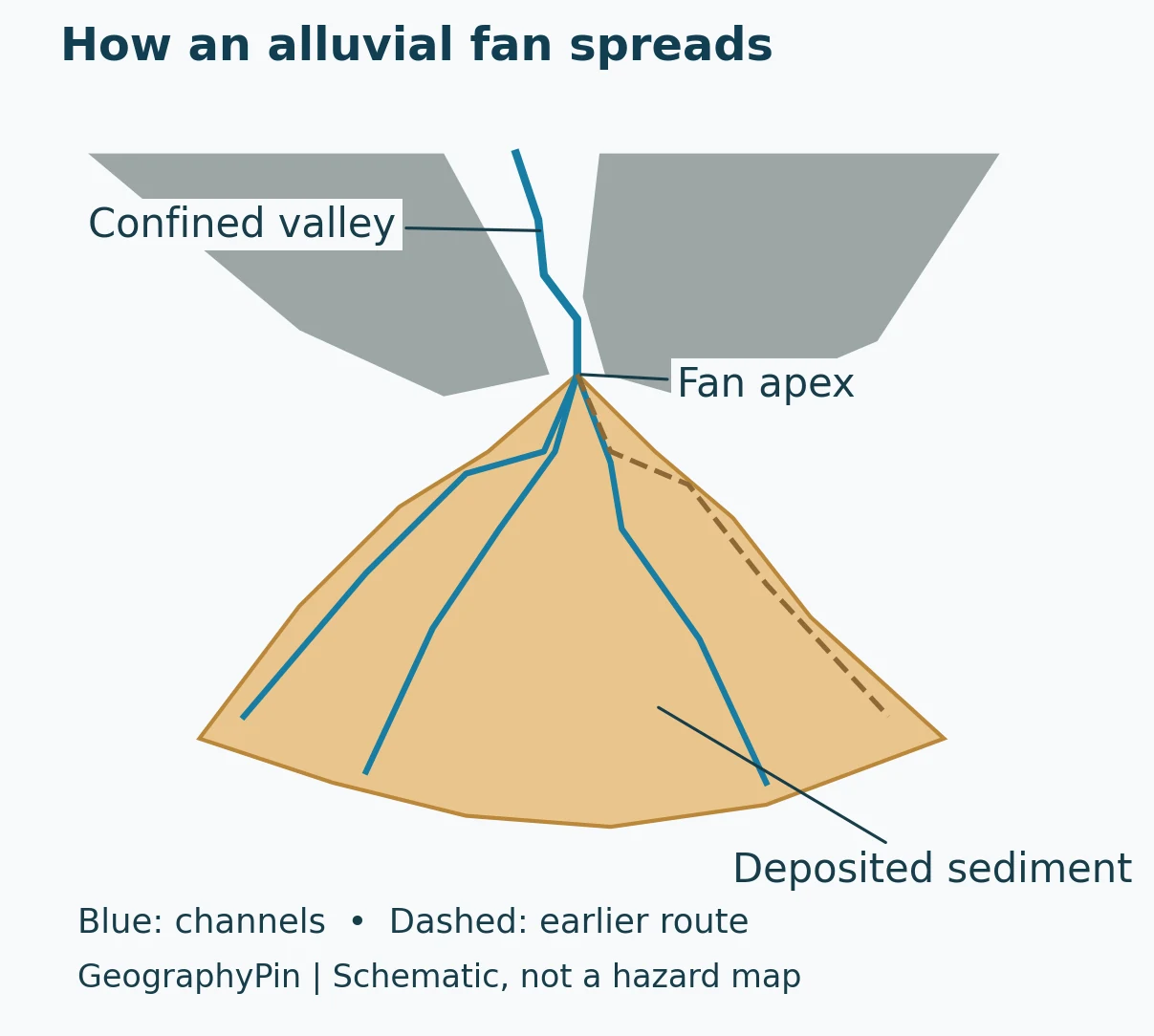
Imagine following a mountain stream downhill. Inside a narrow valley, the valley walls restrict where the flow can go. Beyond the valley mouth, the land opens out. Sediment deposited there may build a surface that spreads outward rather than remaining confined to one narrow corridor.
The narrow upper end is the apex; the broader, lower part extends toward the surrounding valley or basin. The familiar fan shape is easiest to recognize from above, but real fans are not perfect semicircles. Neighboring landforms, erosion and later deposits can interrupt their outlines. The USGS landslides glossary describes the typical fan as an outward-spreading accumulation with its apex at the valley mouth.
Read the surface, not just the outline
A useful first observation is the relationship between a confined upstream valley and a broader sediment-covered surface below it. Look for channels that spread away from the mountain front, rather than assuming every triangular patch of ground is a fan. The diagram illustrates that relationship; it is not a template for drawing a real boundary.
A fan is a landform made of deposits, not simply a stream that splits into several channels. Its visible channels are only part of its history. Deposits beneath the surface and channels no longer carrying flow can help explain how it developed. This distinction matters when interpreting satellite imagery: an aerial pattern is evidence to investigate, not a complete geological history.
2. How alluvial fans form
Sediment leaves a confined valley
Rock and soil eroded upstream can be transported through a mountain drainage. At its outlet, a flow gains room to spread. Under suitable conditions it deposits sediment, adding to the fan. Repeated deposition in different places helps construct the broader surface.
A simple explanation says that a stream slows down and drops its sediment. That is a useful starting point, but it is not a complete rule. A flow does not necessarily deposit every grain at the canyon mouth. Sediment supply, transport capacity and how water divides across the fan all matter. USGS research summarized by Stock emphasizes these interacting controls for water-laid fans.
Streamflow and debris flows are different
In streamflow, water transports sediment along a channel. A debris flow is a moving mixture of water, mud, rocks and other material, not merely an ordinary stream with slightly cloudy water. Both can contribute to fan-shaped deposits, but their movement and the resulting hazards should not be treated as identical.
The Utah Geological Survey describes debris flows traveling down mountain channels and spreading onto fans when they lose confinement. Its broader geological guidance recognizes fans containing both streamflow and debris-flow deposits. Some scientific treatments use “alluvial fan” more narrowly for predominantly water-laid deposits, so the terminology can depend on the classification being used.
The building channel can change
A fan need not grow evenly across its whole surface. Deposition may affect one part during an event and another part later. Channels can shift, allowing sediment to accumulate away from an earlier route. The National Park Service’s explanation of arid landforms highlights this movement across a developing fan.
The result is not a single photograph frozen into a permanent drainage plan. When reading an image, separate the fan’s overall form from the particular channels visible at the time. Neither the most obvious channel nor a neatly drawn fan edge tells you exactly where the next flow will travel.
3. Alluvial fan, delta, bajada or pediment?
These terms describe different relationships between sediment, water and the surrounding landscape. Shape alone is not enough to distinguish them.
| Landform | Main distinction | What not to assume |
|---|---|---|
| Alluvial fan | Sediment spreads beyond a confined valley or mountain drainage | Every fan is a perfect triangle or built only by ordinary streamflow |
| Delta | River-delivered sediment accumulates where the river enters a standing body of water | Every delta has a triangular outline |
| Fan delta | A fan extends from nearby high ground into a lake or sea | “Fan” and “delta” are always mutually exclusive |
| Bajada | Neighboring fans join into a broader apron along a mountain front | One isolated fan is a bajada |
| Pediment | A gently inclined erosional surface near a mountain front, commonly cut into bedrock | Every gently sloping surface below mountains is a sediment-built fan |
A fan can also meet a lake or sea
The usual classroom contrast is helpful: a fan spreads onto open ground, whereas a delta develops at a river’s entry into standing water. But it has an important exception. A fan delta connects the two environments. James Madison University’s sedimentary-geology teaching material describes a fan advancing from adjacent highland into a lake or sea.
That is why “alluvial fans never touch water” is too absolute. The better question is what the sediment is entering and how the deposits connect to one another. Our delta versus estuary guide explains another distinction at river mouths.
A bajada joins several fans
When fans from adjacent drainages merge, the combined apron is called a bajada. Their individual edges may become less obvious. A pediment is different again: its essential character is an eroded surface rather than a fan-shaped sediment accumulation. Both distinctions are covered in the National Park Service’s arid-landforms guide.
4. Real examples: Mongolia and the Rocky Mountains
Southern Mongolia: overlapping fans from space
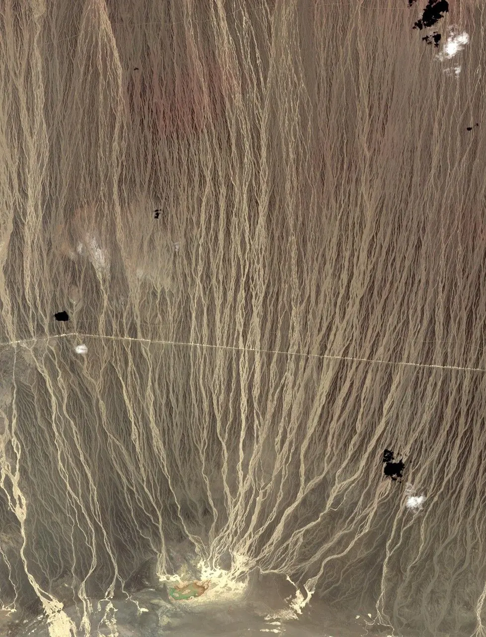
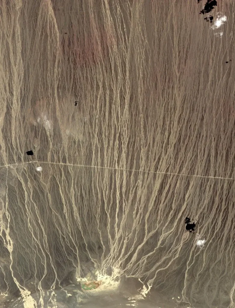
The image shows branching sediment pathways south of the Tost Mountains in southern Mongolia. NASA identifies the wider setting as a bajada, where several fans have joined. It is a useful example precisely because the landscape is more complicated than a single neat fan in a textbook drawing.
NASA explains that runoff from the mountains moves through confined drainages before spreading into channels across the lower terrain. The image was acquired by the ASTER instrument aboard Terra in 2014. It is not a live view and should not be read as a map of today’s flowing water. See NASA’s original image and explanation.
Rocky Mountain National Park: a documented rapid change
Alluvial fans are not restricted to deserts. In Colorado’s Rocky Mountain National Park, the place named Alluvial Fan includes a boulder-strewn area formed after the Lawn Lake dam failed in 1982. The National Park Service describes the flood carrying debris down the Roaring River drainage and creating the fan visitors see there.
This example demonstrates that a conspicuous deposit can be produced by a particular event. It does not mean all fans form through dam failures or appear fully formed in a single flood. The NPS description of Alluvial Fan documents this site’s specific history rather than a universal mechanism.
Why desert examples are so familiar
Fans are prominent in many arid and semiarid landscapes, where they are often easy to identify along mountain fronts. Yet “common in deserts” and “exclusive to deserts” are different claims. Compare the Mongolian imagery with the Colorado example before using climate alone to classify a landform. Our U.S. deserts map provides broader geographical context for American desert landscapes, not an inventory of individual fans.
5. Why a fan outline is not a flood-hazard map
Gentle ground can have a dangerous history
A relatively gentle surface below steep mountains can look like convenient land for roads and buildings. That appearance does not establish that it is safe. The same drainage that supplied the sediment may deliver future floods or debris flows.
A USGS account of the December 1999 northern Venezuela disaster describes debris flows and flash floods affecting developed coastal fans. The lesson is not that every fan has the same level of danger. It is that recognizing the landform is only the beginning of assessing a site. The USGS publication summary stresses the need to understand these hazards where development occupies fans.
What a proper assessment needs
A photograph cannot establish flow frequency, expected depth, runout or a safe building location. Utah Geological Survey guidance describes investigations of both the upstream drainage and the deposits on the fan. Past deposits, sediment available in channels and evidence below the surface all contribute information that a simple outline lacks.
Long quiet intervals can also be misleading. The absence of a recent event in someone’s experience is not the same as a geological finding that the hazard has disappeared. Consult current local hazard mapping and qualified site-specific advice when decisions involve property or safety. This article and its diagram are educational, not a substitute for such work. UGS hazard-evaluation guidance
Frequently Asked Questions
Does an alluvial fan have to be dry?
No. The term describes a sediment-built landform, not a requirement that its surface always be dry. Desert examples are familiar, but fans also occur in mountain environments outside deserts. Whether a particular channel is carrying water is a separate observation from whether the surrounding deposit is an alluvial fan.
Can one flood create an alluvial fan?
An event can build a substantial fan deposit, as the National Park Service documents at Rocky Mountain National Park after the 1982 Lawn Lake dam failure. Other fans record repeated episodes and changing channels. There is no single formation time that applies to every fan.
Is a fan-shaped river mouth always an alluvial fan?
No. A similar outline does not establish the same origin. At a river mouth, examine whether sediment is entering a lake or sea, whether a nearby mountain drainage feeds it directly and how the deposits are arranged. A fan delta can combine fan and delta characteristics; appearance alone is not decisive.
What Did We Learn Today?
An alluvial fan records sediment spreading beyond a confined drainage, often at a mountain front. Its apex, channels and deposits help explain that history, but the outline is rarely a perfect geometric fan. Streamflow and debris flows can build different kinds of deposits; joined fans form bajadas, while fans entering standing water can form fan deltas. Real examples range from southern Mongolia to Colorado, and none should be treated as a ready-made map of future flood safety.
Sources & Data Notes
The diagram is an original conceptual illustration, not a surveyed map. Fan terminology varies between water-laid classifications and broader landscape descriptions that include debris-flow deposits. The NASA image dates from 2014 and is not evidence of current conditions. USGS publication summaries are distinguished from full research papers. No flood recurrence intervals or safe development zones are inferred here.
- USGS: Landslides glossary
- USGS: Stock, Waters divided (2022), publication abstract
- National Park Service: Arid landforms
- Utah Geological Survey: Debris flow hazards
- Utah Geological Survey: Debris-flow hazard evaluation
- James Madison University: Fan deltas
- NASA Earth Observatory: Alluvial fans in southern Mongolia
- National Park Service: Alluvial Fan, Rocky Mountain National Park
- USGS: Natural hazards on alluvial fans, Venezuela (publication summary)