The Elbe connects Czech mountain headwaters with a German tidal estuary, but its geography is easy to misread. Prague belongs to its wider river system without standing on the Elbe itself. Hamburg lies on the river without being the point where it meets the open sea. A map makes both distinctions much clearer.
The Elbe, called Labe in Czech, rises in the Giant Mountains of Czechia and flows through Czechia and Germany to the North Sea near Cuxhaven. Its course is about 680 miles (1,094 kilometers) long. Dresden, Magdeburg and Hamburg are on the Elbe; Prague is on its tributary, the Vltava.
Find your bearings: Follow the source-to-sea map, distinguish the Elbe from the Vltava, and explore the tidal lower river.
1. Where is the Elbe River?
Follow the blue line from the mountains toward the sea
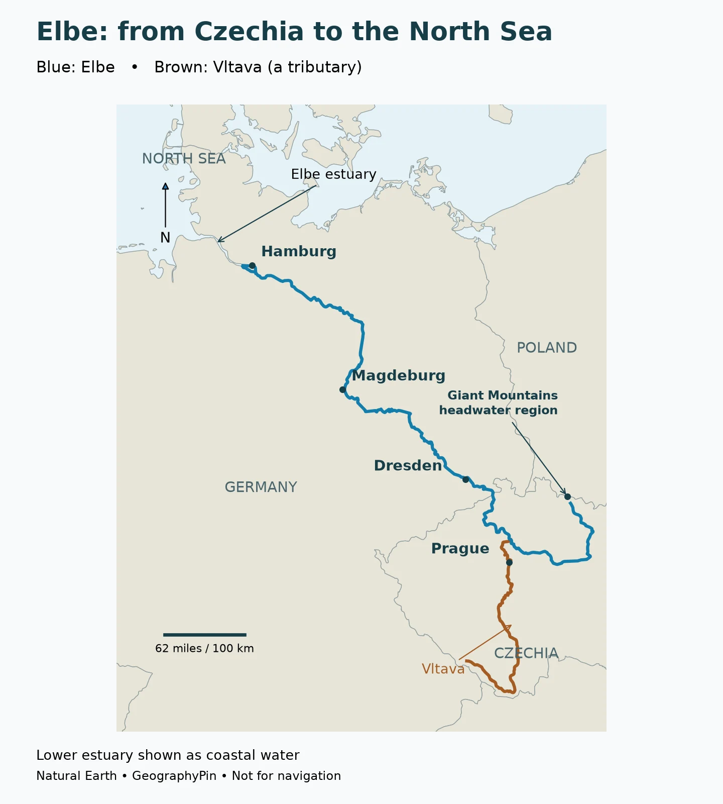
The Elbe is a major river of Central Europe. Starting in Czechia, its course bends through the northern part of the country before crossing into Germany. It passes Dresden and Magdeburg, then continues toward Hamburg and the North Sea. The overall direction is northwest, but the upper river makes a broad bend rather than following a straight line from its source to the border.
Elbe and Labe are names for the same main river, not two rivers that join at the national boundary. English and German maps normally use Elbe; Czech maps use Labe. Recognizing both names helps when comparing maps, signs and official river information from the two countries.
The International Commission for the Protection of the Elbe River, known as ICPER or IKSE, gives a rounded total length of about 680 miles (1,094 kilometers). That is the full source-to-sea course, not just the German section. It should not be confused with a navigation kilometer marker, which belongs to a particular chainage system rather than measuring distance from the natural source in the same way.
| Geographic question | Answer |
|---|---|
| Main river names | Elbe; Labe in Czech |
| Source region | Giant Mountains, or Krkonoše, in Czechia |
| Countries of the main course | Czechia and Germany |
| Receiving sea | North Sea, near Cuxhaven |
| Approximate total length | 680 miles (1,094 kilometers) |
| Selected cities on the main river | Dresden, Magdeburg and Hamburg |
| Prague’s river | Vltava, a tributary of the Elbe |
The map shows a generalized centerline where the river is narrow. Downstream around Hamburg, the waterway becomes part of the broad estuarine water visible in the coastal basemap. The end of the blue centerline is therefore not the end of the river: follow the water northwest toward the North Sea. It is not a shipping channel, bank survey or flood-hazard boundary.
2. From the Giant Mountains to the German lowlands
One course, several different landscapes
The source region is in the Giant Mountains, known in Czech as the Krkonoše. This mountain setting is different from the wide, low-lying estuarine landscape at the other end of the river. Between them, the Elbe links upland valleys, cities, agricultural lowlands and a maritime port region.
In Czechia, the upper course turns through a broad arc before heading toward the German border. The Vltava joins the Elbe near Mělník. After the border crossing, Dresden provides a useful first major German city anchor on this map. Farther downstream, Magdeburg helps locate the transition toward the extensive northern lowlands.
Upper, Middle and Lower Elbe are defined reaches
ICPER’s geographic overview divides the river into three main sections. Its Upper Elbe runs from the source to Schloss Hirschstein, downstream of Meissen. The Middle Elbe continues from there to the Geesthacht weir, upstream of Hamburg. The Lower Elbe extends from that weir to the sea boundary near Cuxhaven-Kugelbake.
These are river-section definitions, not national divisions. “Upper Elbe” does not simply mean the Czech part, and “Lower Elbe” does not mean every stretch in northern Germany. The Geesthacht boundary is especially useful because the river below it is influenced by the North Sea’s tides.
3. Why Prague is part of the Elbe system but not on the Elbe
The Vltava joins the main river north of Prague
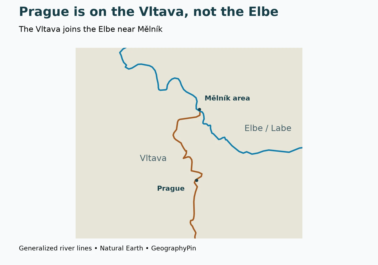
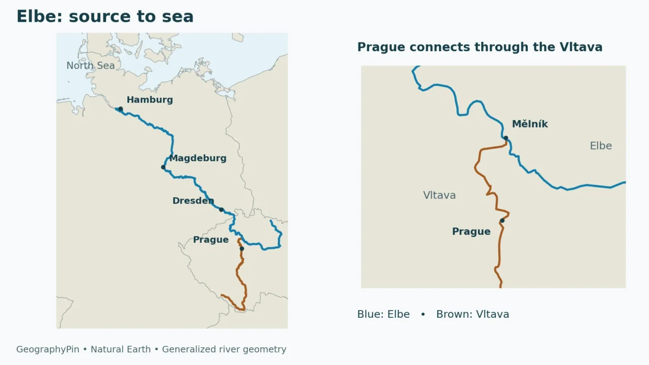
Prague stands on the Vltava, also known by its German name Moldau. The Vltava flows north to meet the Elbe near Mělník. VisitCzechia, the country’s official tourism organization, identifies this confluence in its descriptions of Mělník and the Vltava route.
That relationship explains a common map-reading mistake. A map titled “Elbe river basin” may include Prague prominently, but this does not put the city on the Elbe’s main channel. Water leaving Prague travels along the Vltava before joining the Elbe. The two names describe connected but distinct river courses.
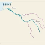
On the map, blue identifies the Elbe and brown identifies the Vltava, showing how Prague connects to the main river through its tributary.
A basin is larger than its main channel
The Elbe’s main course passes through two countries, but the drainage basin includes parts of four: Germany, Czechia, Austria and Poland. The commission reports that more than 99% of that basin lies in Germany and Czechia, with small portions in the other two countries. This does not mean the Elbe main channel flows through Austria or Poland.
Other important tributaries include the Ohře, Saale, Havel, Mulde and Schwarze Elster. Each brings water from its own catchment into the larger system. The map highlights the Vltava to answer the Prague question; it is not intended as an inventory of every tributary.
For a general explanation of the difference, see what a river is, including its channel and drainage basin. A political map and a basin map use different boundaries: one divides jurisdictions, while the other divides where water drains.
4. Hamburg, the tidal Elbe and the North Sea mouth
Hamburg is on the tidal river, not the open coast
Hamburg’s port is connected to the North Sea by the lower Elbe. The city is inland along that waterway, rather than sitting at the river’s outer mouth. Moving downstream from Hamburg takes you through the widening estuary toward the Cuxhaven area and the sea.
The Hamburg Port Authority describes the tidal section as extending from the Geesthacht weir to the North Sea estuary. High and low tides are experienced in Hamburg itself. A river can therefore carry freshwater downstream while also responding to the rise and fall of the sea; those are not contradictory descriptions.
An estuary is a transition between a river and the sea. The Elbe’s mouth has a broad, funnel-like form shaped by tidal processes. It should not be pictured as a single narrow blue line meeting a fixed coastline in the same way as every other river mouth.
Tidal influence is not the same as a fixed saltwater boundary
The upstream reach of a tide and the upstream reach of salty water are different questions. Tide refers to changing water level and movement; salinity refers to the amount of dissolved salt. A map showing the tidal river is not automatically a map of where water is salty at a particular moment.
The reach of saline water changes with river discharge, marine conditions and channel geometry; it is not a permanent line on the map.
The port authority explains that sediment reaches Hamburg both from upstream and from the sea. Maintaining shipping access therefore involves sediment management from both directions.
5. Reading water levels and environmental information correctly
A city gauge is not a measurement of the whole river
A reported water level belongs to a particular station and reference system. It is not the depth of the Elbe everywhere, nor does the same numerical reading necessarily mean the same thing at two different gauges. River stage, discharge and navigable depth are different measurements.
The tidal lower river adds another distinction. A high water level there can involve marine influences as well as conditions arriving from the upstream catchment. The commission’s flood-information page directs readers to different responsible services for inland stretches and the tidal Elbe, reflecting that difference.
For present conditions, begin with ICPER’s current water-level and discharge links, then use the relevant national or regional authority. GeographyPin’s guide to reading a river gauge explains why a station datum matters. Neither this article nor its maps establish whether a property is safe from flooding or a route is safe to navigate.
The river connects upstream and downstream decisions
Water and sediment do not stop at a national boundary. A change in one tributary or an upstream reach can matter farther downstream, although the size and timing of any effect require actual measurements. The river’s cross-border geography helps explain why a joint Czech–German commission exists to coordinate its protection.
That is also why a city-only view is incomplete. Dresden, Magdeburg and Hamburg occupy different reaches, and Prague is on a tributary, but all belong to a connected drainage system. Understanding that network is more useful than treating each waterfront as an isolated feature.
Frequently Asked Questions
Are Elbe and Labe the same river?
Yes. Labe is the Czech name for the river known in English and German as the Elbe. The name change does not mark a confluence or a different river.
Does the Elbe flow through Prague?
No. Prague is on the Vltava, which joins the Elbe near Mělník. Prague is therefore within the Elbe drainage system but not on its main channel.
Does the Elbe reach the Baltic Sea?
No. Its estuary opens into the North Sea near Cuxhaven. This distinguishes it from rivers such as the Vistula, whose receiving sea is the Baltic.
Is Hamburg at the mouth of the Elbe?
Hamburg is on the tidal lower river, upstream of the outer estuary. Ships continue along the Elbe between Hamburg and the North Sea.
Does the Elbe itself flow through four countries?
No. Its main course passes through Czechia and Germany. The wider drainage basin also includes small parts of Austria and Poland.
What Did We Learn Today?
The Elbe, or Labe, connects Czech mountain headwaters with Germany and the North Sea. Its main channel and its drainage basin are different geographic objects: Prague belongs to the system through the Vltava, while the main river passes Dresden, Magdeburg and Hamburg. Below Geesthacht, tides become part of the river’s behavior, and the broad estuary continues beyond Hamburg toward the sea.
Sources & Data Notes
- ICPER: The Elbe: source-to-sea context, basin-country distinction and tributary system.
- ICPER: The Elbe and its basin, 2020 geographic overview: conventional rounded length, named river sections and tidal reach.
- VisitCzechia: Mělník and the Vltava in Prague: the city–tributary–confluence relationship.
- Hamburg Port Authority: waterside access: tidal estuary and sediment context.
- ICPER: flood forecasting responsibilities: inland versus tidal river information.
- Natural Earth: public-domain data: river centerlines, country/coastal outlines and representative city locations.
Map method: Original GeographyPin maps use Natural Earth 1:10m river and country data in UTM zone 32N. The Elbe line is blue; the Vltava is brown. Downstream of Hamburg, the estuary is represented by coastal water rather than a newly drawn centerline. The headwater marker and Mělník label identify approximate regions; city points are representative locations, not municipal boundaries. These are orientation maps, not navigation, basin-boundary or flood-risk maps.
Measurement note: The approximately 680-mile (1,094-kilometer) length is a rounded published reference, not a calculation from the simplified map. No present-day discharge, water level, navigable depth or saltwater limit is estimated here.