The Rhône links three very different landscapes: an Alpine valley, a large lake and a Mediterranean delta. Following the water through all three prevents a common map-reading mistake: treating the lake as the river’s end, or confusing the branches at its mouth with tributaries flowing into it.
The Rhône rises at the Rhône Glacier in Switzerland, flows through Valais and Lake Geneva, then continues into France through Lyon, Valence, Avignon and Arles. It reaches the Mediterranean through the Grand Rhône and Petit Rhône branches of the Camargue delta. Its total course is about 505 miles (812 km).
1. The Rhône route: Alps to Arles
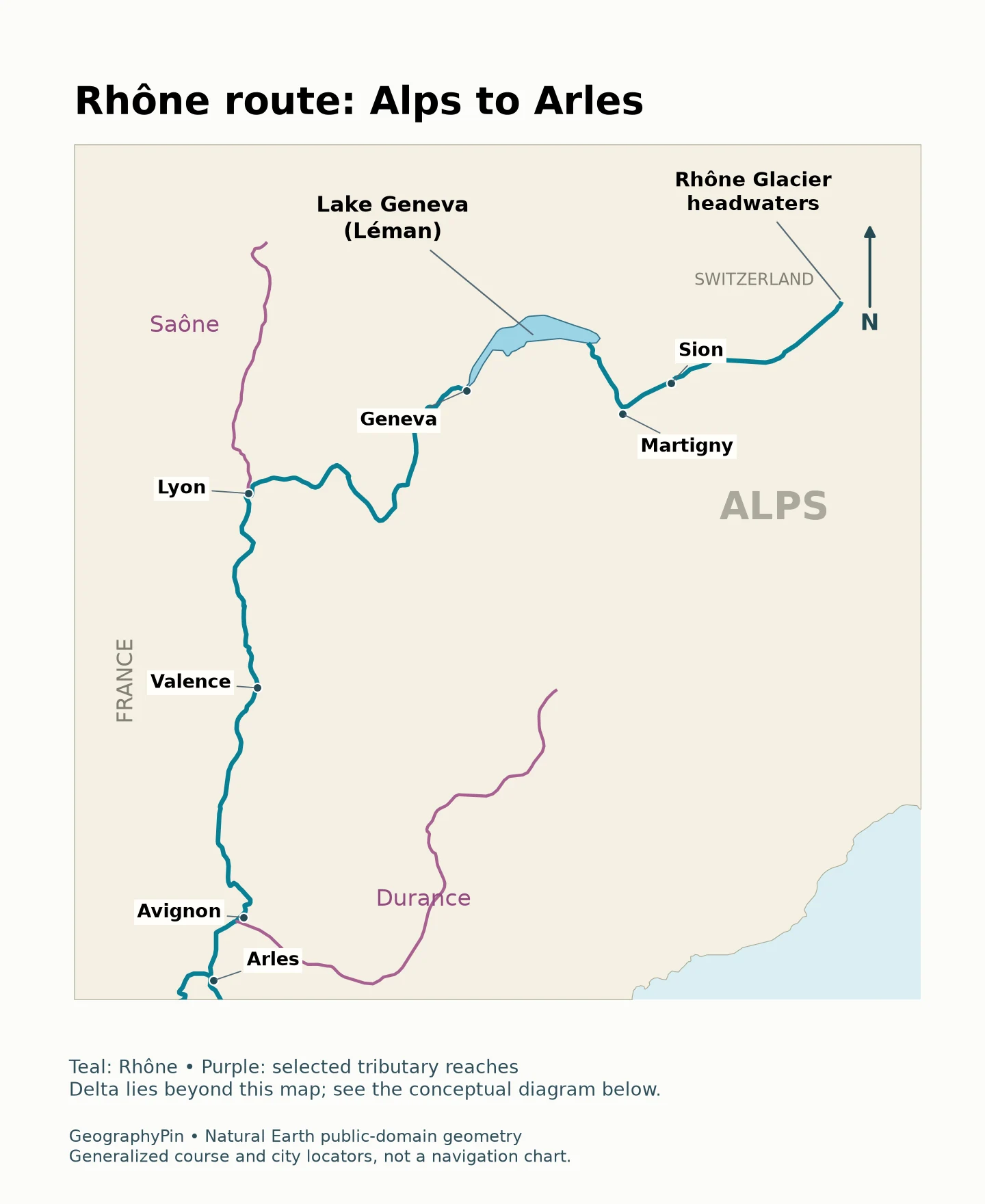
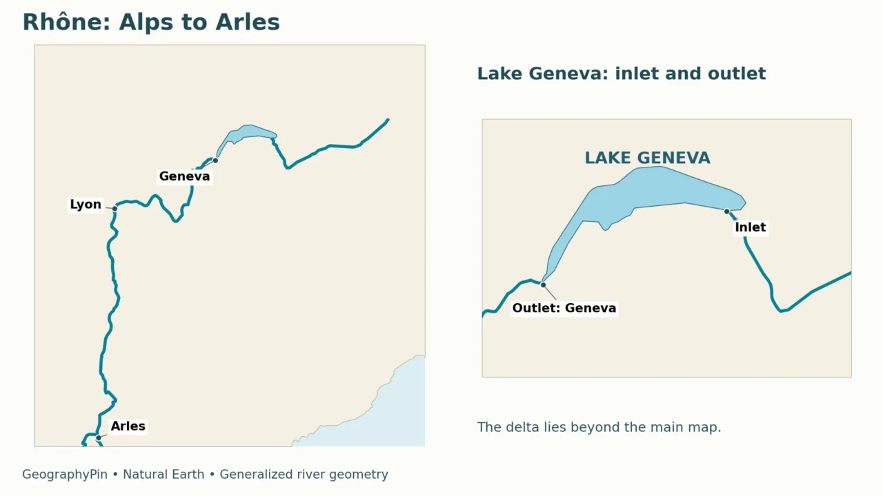
The named headwaters are at the Rhône Glacier in the Swiss Alps. The upper river follows the Valais valley, passing the Sion and Martigny area before turning toward Lake Geneva. “Léman” and “Lake Geneva” refer to the same lake, not two successive lakes along the route.
At Geneva the Rhône leaves the lake and continues toward France. It then follows a winding course toward Lyon, where the Saône joins it. From there the major valley corridor turns south toward Valence, Avignon and Arles. The river finally reaches the Mediterranean through its delta, rather than entering the Atlantic or the North Sea.
| Stage | Geographic reference | What changes here? |
|---|---|---|
| Alpine headwaters | Rhône Glacier and Valais, Switzerland | Mountain river and tributary inputs |
| Lake connection | Lake Geneva / Léman | The river enters a lake and leaves it at Geneva |
| Major confluence | Lyon, France | The Saône joins the Rhône |
| Lower valley | Valence and Avignon | A southward river corridor with further tributaries |
| Delta | Arles and the Camargue | The river divides into branches flowing toward the sea |
Published regional references give a total length of about 505 miles (812 km).
2. How Lake Geneva fits into the river
A lake along the route, not the final destination
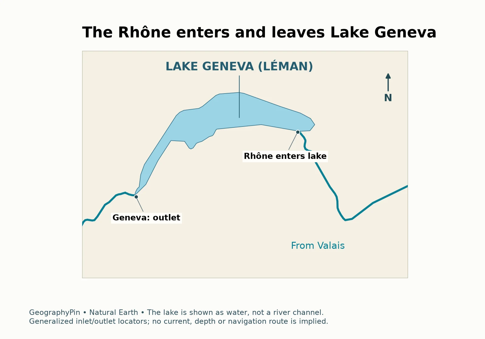
The Rhône enters Lake Geneva at its eastern end and leaves at Geneva toward the southwest. This is a useful example of a river system containing a lake. A continuous drainage connection does not require one narrow visible channel across the intervening water body.
Water stored in a lake does not behave exactly like water in a steep channel. The lake receives inflows, stores water and releases it through the outlet. Its level responds to the balance of inputs and outputs; that level is not the same measurement as the flow rate leaving the lake.
The Canton of Geneva explains that the Seujet structure regulates Lake Geneva’s levels, giving this lake–river connection an operational as well as a natural dimension.
Switzerland and France signed two water-cooperation agreements in September 2025 addressing the Rhône and Lake Geneva. The Swiss federal announcement describes coordination over shared waters and lake regulation, including droughts and floods. This is a practical illustration of why a river crossing a national boundary requires more than two separate local maps.
3. Lyon and the tributary network
The Saône meets the Rhône at Lyon. A confluence adds another river’s water to the downstream flow; it does not split the main river into two sea-bound branches. Keeping this distinction in mind helps when comparing Lyon with the delta near Arles.
The network also includes Alpine tributaries such as the Arve, Isère and Durance, as well as rivers entering from the western side of the lower corridor, including the Ardèche. Their catchments contribute water and sediment from different landscapes. The main-stem name does not mean that all of the water downstream came directly from the Rhône Glacier.
The Arve joins the Rhône at Geneva’s La Jonction, downstream of the lake outlet. That placement matters: an input joining below a lake does not first pass through the lake simply because it belongs to the same larger river system. The same upstream–downstream logic applies to the Saône at Lyon and other confluences farther south.
Our route map shows selected tributary reaches rather than every tributary. For general terminology, see rivers, tributaries and drainage basins.
4. The Camargue delta and its branches
Grand Rhône and Petit Rhône
Near Arles, the river divides into the Grand Rhône on the eastern side and the Petit Rhône on the western side of the delta. Both carry water toward the Mediterranean. These are distributary branches: water separates from a common upstream river rather than joining it from separate catchments.
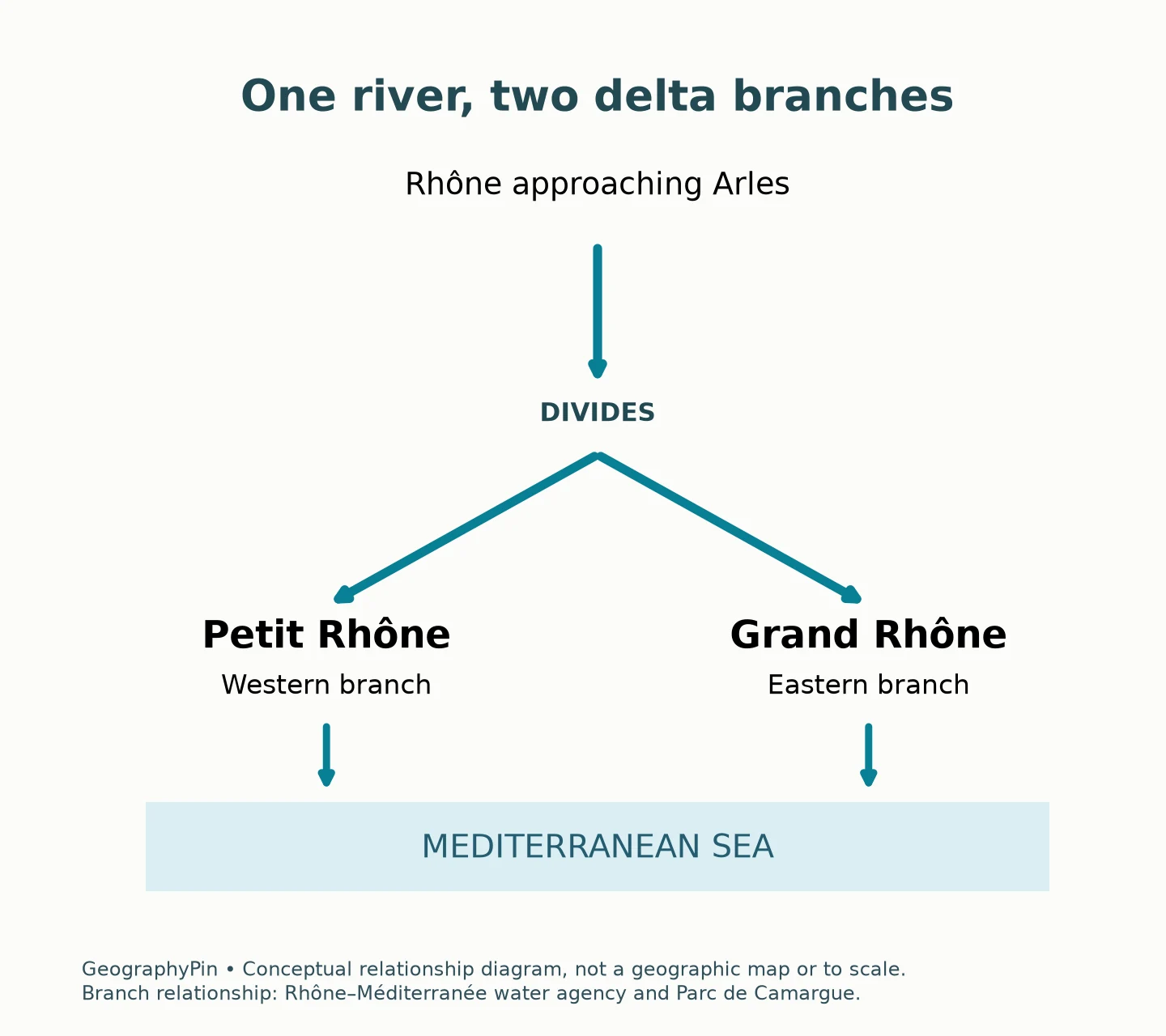
The Parc naturel régional de Camargue describes the delta as a landscape with two active Rhône branches. The land between them is often called the Grande Camargue or Île de Camargue. However, the park, the wider delta and the land between the two channels should not automatically be treated as identical mapped areas.
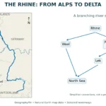
A delta is formed and reshaped by the interaction of river sediment, flowing water and coastal processes. The Rhône’s lower landscape also includes extensive water management and embankments. It is therefore neither a static triangle nor a wholly untouched wilderness. The conceptual diagram explains the branching relationship without claiming to map every lagoon, levee or wetland.
The Petit Rhône’s name does not make it an insignificant channel. The park identifies its role for migratory fish and describes extensive embankments along the river corridor. This is one reason to distinguish the watercourse from the full delta landscape surrounding it.
5. A natural river with managed channels
What does “Vieux Rhône” mean?
In developed reaches, some water can be diverted through a canal serving a hydroelectric plant and then returned downstream. The older or bypassed river channel is commonly called the Vieux Rhône, meaning “Old Rhône.” It remains part of the river system; the name does not mean an abandoned dry bed that is automatically safe to enter.
CNR’s explanation of its installations describes the relationship between diversion canals, power stations and the older channel. Its safety guidance warns that water levels and current speeds below dams can rise rapidly. Operational releases can occur independently of pleasant weather at the place where someone is standing.
This matters geographically because a modern map may show parallel channels along one valley. They are not necessarily separate rivers or permanent natural delta branches. A diversion-and-return arrangement is different from the Grand Rhône–Petit Rhône split near the sea.
A route map is also not a current warning system. Follow local signs and official instructions near dams, islands and gravel bars; do not infer safety from a low-looking channel or an old photograph. For interpreting measured water levels rather than channel appearance, see how river gauges work.
6. Reading Rhône maps correctly
The main map ends at Arles; the delta is explained separately with a conceptual diagram. The Lake Geneva panel uses mapped lake geometry, while the delta arrows show only how the branches connect.
The Rhône and Rhine are different rivers. Their names can look similar in English and French, and both are associated with the Alps, but the Rhône heads toward the Mediterranean. Do not transfer a fact about the Rhine’s North Sea route to the Rhône merely because the names resemble one another.
For orientation at a larger scale, our physical map of Europe places major river corridors alongside mountains and plains. For the Rhône itself, the key sequence is simple: Alpine valley, Lake Geneva, Lyon confluence, lower valley, then the Camargue delta.
Frequently Asked Questions
Does the Rhône flow through Switzerland and France?
Yes. Its Alpine headwaters and upper route are in Switzerland, and it continues into France after leaving Lake Geneva at Geneva.
Does the Rhône end in Lake Geneva?
No. It enters the lake from the east and leaves at Geneva, continuing toward France and ultimately the Mediterranean.
Which river joins the Rhône at Lyon?
The Saône joins it at Lyon. This is a confluence, unlike the division into distributary branches near Arles.
Where does the Rhône reach the sea?
It reaches the Mediterranean through the Grand Rhône and Petit Rhône branches in the Camargue delta.
Are the Rhône and Rhine the same river?
No. They are separate river systems. The Rhône reaches the Mediterranean, while the Rhine system drains toward the North Sea.
What Did We Learn Today?
The Rhône connects Swiss Alpine headwaters with Lake Geneva, Lyon and the Mediterranean. Tributaries such as the Saône add water along the route, while the Grand Rhône and Petit Rhône divide it near the delta. A lake outlet, a confluence, a managed bypass and a distributary split are different features, even though all belong to the same connected river system.
Sources & Data Notes
- Rhône hydrosedimentary synthesis, Mission 2, December 2020: source, route, tributaries, length and eastern/western delta branches. Hosted by the Rhône–Méditerranée water-information portal; geographic context on page 17.
- Canton of Geneva: managing lake levels: Lake Geneva outlet and Seujet regulation.
- Canton of Geneva: Arve floods: the Arve’s confluence with the Rhône at La Jonction.
- Swiss Federal Office for the Environment, September 2025 agreement announcement: cross-border Rhône and Lake Geneva cooperation.
- Parc de Camargue: geographic setting and Petit Rhône site description: delta branches and ecological context.
- CNR: safety near the Rhône: diversion canals, older channels and changing water levels.
- Natural Earth physical vectors and public-domain terms: generalized river, lake and land geometry, styled by GeographyPin.
Cartographic method: select actual Rhône river features, excluding the lake-centerline feature so that no channel is implied across Lake Geneva. Show selected Saône and Durance reaches, with the main frame ending at Arles. City and headwater locators are approximate. No detailed delta linework, water-depth data, drainage boundary or current navigation route is invented. The separately labeled delta diagram is conceptual, not mapped geometry.